| GISdevelopment.net ---> AARS ---> ACRS 1996 ---> Education / Communication |
Ground Truth Database with
Portable GPS for Education
Shiro Ochi* and Masataka
Takagi**
*Dept. of Forestry, Utsunomiya University 350 Mine,
Utsunomiya Tochigi Japan, 321
Tel: +81-286-49-5537 Fax:+81-286-86-5545
Email : ochi@cc.utsunomiya-u-ac.jp
*Institute of Industrial Science,
Univ. of Tokyo7-22 Roppongi, Minato-ku, Tokyo Japan, 106
Tel:81-3-3402-6231 (ext2563) Fax:+81-3-3479-2762
Email : mural1@shunji.iis.u-tokyo.ac.jp
Abstract *Dept. of Forestry, Utsunomiya University 350 Mine,
Utsunomiya Tochigi Japan, 321
Tel: +81-286-49-5537 Fax:+81-286-86-5545
Email : ochi@cc.utsunomiya-u-ac.jp
*Institute of Industrial Science,
Univ. of Tokyo7-22 Roppongi, Minato-ku, Tokyo Japan, 106
Tel:81-3-3402-6231 (ext2563) Fax:+81-3-3479-2762
Email : mural1@shunji.iis.u-tokyo.ac.jp
Field survey and investigation for remote sensing image interpretation and processing is quite important at the introduction of remote sensing technique for beginners. By the development of portable equipment such as note PC, handy GPS, Digital Camera, etc., on-site education and training can be possible. In this study, integrated database system with GPS and digital camera are introduced. The system is providing three function: (a)Geometric Correction, (b)Classification, and (c) Database management and Utilization. For the geometric correction, positioning method using handy type GPS is discussed. For classification, a hierarchy clustering method which can be combined with filed investigation is introduced. For database management and utilization, data standardization and data management system is discussed. The developed system is expected to make ground investigation effective in quality.
1. Introduction
It is not seldom to process the remote sensing data without enough information about the study area, at the start of new projects. Moreover, when the site is in the abroad, the ground survey and investigatin can be done only one time, in many cases. On the other hand, interpretative image or imge land cover of from the false/natural colored composite image sometimes guide beginners on remote sensing to have preconceived idea for the remote sensing image processing.
In this study, an integrated system for ground truth gathering system with a handy GPS is development, and an education software for remote sensing beginners is provided using image database which is constructed using the developed ground truth gathering system.
2. Flow of Processing
Fig. 1 shows the out line of the remote sensing data processing. Following procedures are considered in this study,;

Figure 1 Handy GPS Positioning Accuracy (Sequential Average)
- Geometric Correction
- Classification using training dataset
- Database management and utilization
At the classification procedure, an image interpretation by an expert who knows the site well is expected. Otherwise, training data should be picked up by a non-expert by means of field investigation.
Both in geometric correction and land cover classification, the procedures are very much depends on the experience and technique of the operator. And the working logs are not recorded or ignored in many cases, and end users use the outcome without the any questions.
The system in this study provides the remote sensing technician and beginner to keep the information acquired from the field survey and utilize the database both for the ongoing processing and education purpose.
1. System Configuration
The hardware configuration of this system is followed:
- Note Type PC :Intel 486Dx450Mhz, 8M RAM, Windows 3.1
- Handy Type GPSl GARMIN GPS38J
- Digital Camera : CASIO QV 100
- CD-ROM Drive : SONY PRD650
4. Functions
4.1 Geometric Correction By the recent innovation of GPS technology, many types of GPS are available. In this study a handy type GPS named "GERMIN GPS38J" are selected because of (a) valid accuracy of 20-30 which is effective for LANDSAT-TM image identification requiring at least 30m positioning accuracy, and (b) portability. FIG-2 shows a time series average accuracy changes for 1,000 seconds. From this figure, GPS positioning requires about 10 minutes for each point in order to get 30nm accuracy in horizontal plane.
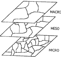
Figure 2 Handy GPS Positioning Accuracy (Sequential Average)
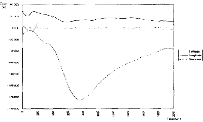
Figure 3 Classification Hiearchy
GCP should be distributed equally into the whole image of study area. Incase enough GCP can not acquired from the field survey, existing topomap will be used foradditional GCPs. In this system, affine,2nd order and 3rd order transformation formula for geometric correction are supported. Moreover, navigation function is included in this system.
4.2 Ground Truth and Classification
Handy GPS and Digital Camera are for gathering Ground Truth (GT) classification is instructed as follows:
Firstly three different types of clustering process are carried out. Macro clustering make rough classification with 6 to 8 categories, and meso clustering has about 100 categories. A hierarchy of relationship between categories in the different class resolution image will be established, then field investigation will be made for the categories in the micro scale classification. Pictures of the GT are recorded with the position information.
It is difficult to take GT for all micro categories, some typical micro categories are selected from meso categories, and checked. Ana a typical reflectance characteristics is selected from 9 pixels around the target GT including itself because the positioning accuracy to expected around 30m. The final classification will be done using existing meso classification, or supervised classification using the GT databaset. Even it is the same category-such as paddy field -in the different image, season, or region, the radiometric characteristics are different and it can be recognized from the GT database.
In case no information are given onto the image to be processed, some adequate land cover categories are suggested using a key of reflection characteristics from the GT database. By the standarization of the GT database, data acquired form independent field investigation can be accumulated and utilized for the training and education purpose.
2. Discussion
The developed system has 3 functions : (a) geometric correction, (b) classification, and (c) database management. These are all fundamental procedure for remote sensing image interpretation and processing, so that instruction these subject to beginners is also quite points of user interface are (1) Visible, 9s) more mouse operation, less key input, (3) fw instruction and more help and (4) popular and inexpensive equipment. The system is still under the trial version and improvement should be made according to the users requests.
References
- TOMITAMK and MATSUYAMA, H(1996) Development and investing of Semi-Differenctial GPS, Theory and Applications of GIS, Vol 14, No. 2, pp. 15-27.
- TSUCIYA, J. and TSUJI, H. (1995) GPS Sikuro-no kiso, survey Association of Japan (Nihon Sokuyo-kyokai)
- Japan Associations on Remote Sensing (1993) Remote Sensing Note.