| GISdevelopment.net ---> AARS ---> ACRS 1996 ---> Education / Communication |
High School Level Education
of Geoinformation Science Using 3D Computer Graphic
Hideharu
yanagi1, Hiroaki Kakiuchi2, Naoki
Akimori2, Kunihiko Ono2
1Department of Civil Engineering, Tokyo Denki University
Hatoyama, Saitama, 350-03, Japan
TEL : +81-492-96-2911 FAX: +292-96-6501
2Chuo-Chizu Co, Ltd.
3-15-22 Funato,Itabashi-ku, Tokyo 174-Japan
Tel : + 81-3-3967-1781 Fax : +81-3-3967-1503
E-mail : chuo-map@sag.bekkoame.or.jp, Chuo-map@po.iijnet.or.jp
Abstract 1Department of Civil Engineering, Tokyo Denki University
Hatoyama, Saitama, 350-03, Japan
TEL : +81-492-96-2911 FAX: +292-96-6501
2Chuo-Chizu Co, Ltd.
3-15-22 Funato,Itabashi-ku, Tokyo 174-Japan
Tel : + 81-3-3967-1781 Fax : +81-3-3967-1503
E-mail : chuo-map@sag.bekkoame.or.jp, Chuo-map@po.iijnet.or.jp
The geography is one of the subject in Japanese elementary, Junior and high school, and the Ministry of Education provides a guiding object of geography. But, it is very difficult for teachers to give instruction these because there are too much data in spite of less school hours.
By the way, many personal computers are installed in schools for supporting education in Japan. Computer instruction doesn't go in all school because there is only few teachers to be able to use computer for education.
With the motive, trial software for education were made in this paper.
1. Introduction
The geography which is called 'CHIRI' in Japan is one of the subject in Japanese elementary, junior and high school. As a guiding object of geography, the Ministry of Education and the provides that the geographical way of viewpoints or thinking should be educated and the nature as a Japanese living in international society should be cultivated by make students realize a regional characteristics on life and culture of world-people and its trend, and consider the difference between the Japan and the World in all its aspect.
This guiding object is divided into following four items; The present day and community, The human beings and environment, the life and industry, the World and Japan. Furthermore, each four item is divided into three or five subitems.
This investigation paid attention to "The present day and community" in four items because it seems that other items be able to understand by means of understanding this item. "This present day and community", however has extremely wide applications. Therefore, this paper discuss two followings. These two subitems are" The World and Map on the globe surface "and" The geographic information and Map". By the way, low-priced and high-functional personal computer has been spreading very energetically in Japan. With this motive, many personal computers are installed schools for supporting education. At the present stage, however, many schools don't have enough teacher who can have a class using personal computer and the software for education.
The main focus theme of this paper is consideration and trial manufacture of software for the education of geography by understanding the present status of education of geography, especially education for "The World and Map on global surface "and" The geographic information and Map".
2. The status of education of geography
As a guiding object of education for "The World and Map on globe surface "and" the geographic information and Map". The Ministry of Education provides as following:
-The world and Map on globe surface-
The teacher make students understand the direction, position, distance on globe surface, time difference and using World map by guiding the much difference of the direction and position between globe surface and field of daily lire.
-The geographic information and Map-
The teacher have to instruction in way to understand characteristic of community through exercise of choosing the community information, handing a data and drawing a map. The teacher also have to instruct that map and image which are able to use in daily life were made under the certain aim.
How to well use map and image is common point between these two guide way. By complaining and connecting globe and world map, the teacher instruct in the relationship between the direction and position on surface of the earth. Furthermore, by using road map. Sightseeing map, satellite image and scene picture, the teacher instruct in way to understand characteristic of community.
But, it is very difficult to give instruction these because there are too much data in spite of less school hours. Too much data cause confusion not only teacher and student. To the country, the teacher can't give correct instruction in the case of less data.
The authors concentrated on efficient arrangement for increasingly data and providing to student in brief.
3. Computer Education
Many personal computer are installed in schools for supporting education as mentioned above. But teachers who are able to use computer are only fifty percent in teachers of High School, and teaches who are able to instruct in computer are only forty-two percent in teachers who are able to use computer. At the moment, computer instruction doesn't go in all school. But the Ministry of Education is carrying forward the promotion of the computer instruction.
As many personal computers are installed in schools, demand for software goes on increasing. Even if the teacher can master the computer, it there are not software the teacher can't instruct. Furthermore, the students takes a leading part in the computer education. Therefore, developing a software which is very easy to use become important subject.
4. Development Software for Education
With motive, the authors have been concentrated developing software. The information for a certain point can be easily obtained by pointing the direction and position on globe surface. This is the conception for this software and the detailed information for this trial manufacture software are as follows:
Fig. 1 shows world map and globe and illustration of city by the software of city by the software.
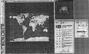
Figure 1 World map, globe and illustration of city
The illustration of world map can be change in response to uses by using land-use data, land-shadow data and satellite image which were prepared.
Globe surface change in response to change the illustration of world map because globe is connected with world map. By using this connected function, image information can be also obtained excepting character.
The software have another function. For example, more detailed by using a function of expansion and reduction. The distance between two points can be also obtained by opining two points with mouse.
Globe showed in Fig.2 can be turned to all direction by using mouse. This function be a help to understand the position relationship between the plane the surface of the globe.
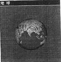
Figure 2 Globe
This software also have a function which able to display the bird's view map show in Fig.3.
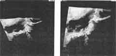
Figure 3 Bird's-eye view
Similarly, this function be a helpful to user because the user can obtain three dimensional information.
Fig. 4 shows an example for the NAGANO Prefecture in Japan. It's possible for these small area to show much data than word and possible to overlap the additional data such as
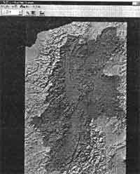
Figure 4 NAGANO Prefecture
Shown in Fig. 5 The various community feature can be obtained as a visually by devising the combination of data.
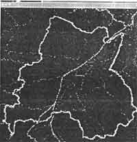
Figure 5 Overlap the additional data
In order to obtain more detailed information of community, geographic information menu such as shown in Fig. 6 were prepared in this software. For example, when it is needed to obtain more detailed information for one the mountain in this area, explanation and images such as shown in Fig. 7 can be obtained with easy by using menu.
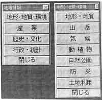
Figure 6 Geographic information menu
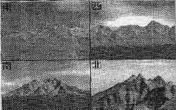
Figure 7 Picture of mountain
The above discussions show only some of example for this software, it is concluded that this software, it is concluded that this software is a useful tool for computer education.
5. Conclusion
In this paper, trial software for computer education were discussed. The performance of this software did exactly what was expected. There are, however, some issues which is need to resolved before this software may become operation. These problems include, addition data, additional functions and efficient renewal of data by utilizing inter net system.
However, it is concluded that these software are become useful tool for geographic education in elementary, junior and high school.