| GISdevelopment.net ---> AARS ---> ACRS 1996 ---> Education / Communication |
The Integration of Dragon
Image Processing System into the Remote Sensing Curriculum - The
Interdisciplinary Approach
M. Zeman
School of Geoinformatics, Building and Planning,
Faculty of Engineering and the Environment,
University of South Australia.
The Levels, south australia 5095
TEL : +61 88302 3026 FAX: +61 88302 3375
E-Mail : mike.zeman@unisa.edu.au
Abstract
School of Geoinformatics, Building and Planning,
Faculty of Engineering and the Environment,
University of South Australia.
The Levels, south australia 5095
TEL : +61 88302 3026 FAX: +61 88302 3375
E-Mail : mike.zeman@unisa.edu.au
Academic institutions worldwide, in trying to respond to extremely raid technological changes through curricula adjustments, are presented with some significant challenges. While there exists a commitment to ensure that the latest developments in spatial information technologies are available for student use, the cost in terms of hardware and software needed to support them are enormous. This at a time when the academic institutions are under severe financial pressures. This paper highlights the need for interdisciplinary collaboration in securing a relatively inexpensive PC-based software package for teaching remote sensing components of spatial information technologies.
Introduction - The School of Geoinformatics, Planning and Building, University of South Austrialia
The School, formerly known as the School of Surveying at the then South Australian Institute of Technology (SAIT). can trace its beginnings to 1969 when its first courses in surveying and cartography were introduced. One of two institutions offering post-secondary education in these specialized fields in South Australia, the School has been the only on that offers a four year degree course that has been accepted by the Institution of Surveyors (South Australian Division) as the education qualification for cadastral license or general registration as a surveyor under the Survey Act. Additionally, the School of Surveying offered courses at a para-professional level namely the Associate Diploma in either Surveying or Cartography, undertaken over two years full-time or four years part-time. Both associate diploma programs offered by the School were reaccredited with the first year in each course commencing in 1995, an explanation of the philosophy behind the revised curriculum design given by Tan and Larden (1995).
Amalgamation with other educational institutions resulted in SAIT attaining university status, the School of Surveying located within the Faculty of Applied Science and Technology. Further restructuring of faculties have since taken place, the School of Surveying since grouped with other schools into the School of Geoinformatics, Planning Building
Faculty of Engineering and the Environment. This paper is not intended to discuss the influence of the Federal Government on the structure and management of universities inclusive of forced amalgamations, levels of funding, budget cuts, etc. An interest reader is referred to a paper by Trinder (1994) who provides a comprehensive overview on this subject.
Technological Change
The School, like many others in Australia and indeed worldwide, has experienced profound changes in technology, these especially in the area of spatial information. In order to meet these new and up to now unprecedented challenges, the School had to revise its extant courses to keep abreast of change and equally equip its students with the knowledge and skills necessary for a career in the rapidly evolving disciplines it is responsible for. The School responded to the changes by not only revising the extant courses but also developing an entirely new course namely in Earth Information System. The Course has been designed to prepare undergraduates who not only understand the developments of but more importantly can apply spatial information systems to earth processes.
The development of this course has been timed to match the growth in spatial information systems industry, particularly in South Australia, where this industry has been targeted by the State Government as a significant component of this State's information technology enterprise.
The School thus currently offers three courses namely the Diploma of Applied Science (Spatial Information Systems), the Bachelor of Geoinformatics and Surveying, and the Bachelor of Earth Information system.
The overall aims and objectives of the three courses are similar although there are underlying philosophical differences between a degree and diploma. Without discussing the current three distinctive course structures and contents in detail, it is worth describing their characteristics (Figure 1).
It is expected that the Bachelor of Earth Information Systems course, concentrating on the analysis and integration of data with a view to board ranging applications within the human and the physical environment will undoubtedly attract greater interest. It is equally expected that its graduates will find employment in a broad range of areas encompassing environmental studies, natural resource management, land and asset management, planning and population studies where information, analysis and graphic displays are the common link.
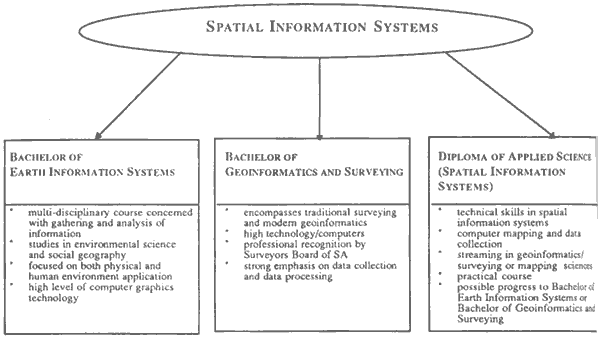
Figure 1 : SIS courses at the University of south Australia
Teching Remote Sensing Component of Sis
The remote sensing component within the extant courses curricula has always been strong this underpinned by a number of research projects undertaken by staff. UNIX operating system software has been purchased, namely the ESRI ARC/INFO, ERDAS/IMAGINE (DEC workstations). Whilst such small laboratory may have been adequate for teaching a small number of student, typically 12-15 per class, it posed severe limitations on classes that suddenly increased to over 80 per class, this owing to joint teaching with other schools, namely Human and Environmental Sciences and Applies Geology. Disregarding each of the above School's unique circumstances, the philosophy behind their respective curricula and numerous other issues concerning the integration of modern technologies into their newly, developed courses, the common link involving the three schools lay in the diffusion of spatial information technologies, namely that the remote sensing within their respective disciplines.
Discussions concerning the teaching and instrumentation delivery of digital image processing within subjects that deal with remote sensing were held, involving the subject coordinators from the three schools. In addition to discussing the current status of education in the remote sensing field in general, and digital image processing in particular, numerous other issues of concern were of pragmatic nature. These involved the large size of the classes, the diverse profiles of undergraduates from several different disciplines and, last but not least, a chronic lack of funds. The following conclusions were reached :
- Expedient teaching/instructional delivery of digital image processing cannot be met with a minimal computer configuration. A multiple station laboratory is necessary.
- While three may exist a need to teach undergraduates the intricacies of digital image analysis via one of several highly integrated systems which have since emerged as marked leaders, such systems are not applicable or appropriate to teaching the concepts of this technology in the three schools remote sensing curricula owing primarily to their UNIS-based environment.
- Inasmuch advantageous and suited to research they may be, the initial high cost, necessary upgrades preclude them from use the teaching and instructional delivery to undergraduates.
DRAGON, a PC-based digital image processing system from Goldin-RUDAL systems, Inc, one of a few commercially available relatively inexpensive software packages had been identified as ideally fulfilling the above needs. Consequently, DRAGON multiple-seat license had been jointly purchased by the three schools.
Dragon Image Processing System
DRAGON, even in its basis from (Academic Edition), provides a robust suite of analysis and display features inclusive of images display, enhancement, classification, geometric corrections and utility operations. Depending on the particular graphic card and monitor used, DRAGON'S software is capable of displaying as few as four colour to as many as 16 million, resolutions ranging from 320 x 200 to 1024 x 700.
Aside from a variety of digital data display options DRAGON offers the whole gamut of image processing and analysis procedures inclusive of the two-band summing and differencing, band rationing, normalized vegetation index, binary masking and spatial filtering with several options. DRAGON external import/export utilities include the capability to read many popular file formats considered standard. Additional external utilities are included in Professional Edition.
The School of Surveying acquired a single-seat (Dragon Release 3.05) at the end of 1992. The system has served the School well in teaching undergraduates even though it had to be done on a roster basis. Additionally, DRAGON has been by a number of students for their final year projects.
The author, though study leave undertaken in the first half of 1994, was offered an opportunity to further investigate the applications of DRAGON's software in education, research and consultancies through discussions with a number of systems users in Great Britain.
Following a joint purchase of DRAGON's multiple-seat license by the three schools in the later half of 1995 the software has been since installed on one of the extant computer pools provided by the University for teaching purposes. The pool has 220 networked PC compatible microcomputers, all of which have the DRAGON software security key installed. The workstations are 486's with 16 Mb RAM and 540 Mb hard disk drive. The network adaptor card installed are Etherlink III'S the networking software used to connect the workstations to a server in the Compuer Centre (physically located in another (physically located in another building from the pool) is Microsoft LAN manager. The server is a 486 microcomputer with 32 Mb RAM and 1 Gb hard disk drive running the Microsoft window NT Advanced Server software. This server also has 7 CD drives installed but the installation and running of DRAGON has no requirement for this facility at present.
Installation of the software, initially a single seat followed up by a multiple-seat license on a network, was performed by way of a setup program, which configures DRAGON for the appropriate display device. Setup was simple and error free.
DRAGON multiple-set installation has been made available to students since the first semester of 1996. The first class to utilise this facility was a subject entitled "Dnvironmental Remote Sensing", taught jointly by the School of Surveying and Human and Environment Sciences, Faculty of Applied Science and Technology. The format of the class was two lectures and one two-hour tutorial/practical session per week. As there were 42 students in class it was necessary to hold two tutorial/practical sessions.
In addition, students in the final year of the Bachelor of Surveying degree course have used DRAGON for their major projects. The students are required to undertake an individual project in which they research, investigate and report work in an approved topic. The purpose of the project is to give the student experience in the design and implementation of major work in the fields of surveying, spatial information systems, satellite geodesy, remote sensing and photogrammetry. Assessment is done via interim review, report quality as well
As seminar presentation at which representatives of industry are present. Topics chosen reflect the wide range of research interests held by academic staff of the School. It is pleasing to see that ever since the introduction of Dragon more students have elected to investigate topics of remote sensing using this software package. Example of projects carried out include:
- lineament analysis of the Musgrave Ranges, South Australia
- evaluatin and comparison of the various supervised/unsupervised methods of classification
- investigation of the various coordinate techniques for georeferencing remotely sensed imagery
- land cover mapping.
An increased emphasis on modern technologies requires a commensurate acquisition of computing components needed to support it. This at a time when academic institutions are under severe financial pressures. The paper highlights the need for interdisciplinary collaboration which resulted in a procurement and implementation of DRAGON as a suitable education vehicle for teaching the intricacies of digital image analysis. The system now forms an integral part of remote sensing curriculum.
References
- Tan, C.K.F. and D.R. Larden (1995). Undergraduate surveying courses at the University of South Australia. The Australian Surveyor, Education Supplement, June.
- Trinder, J.C. (1994). Impact of education policies in Australia on surveying and research. The Australian Surveyor, Education Supplement, March.
- Zeman, M. (1994). Professional experience program report. University of South Australia October.