| GISdevelopment.net ---> AARS ---> ACRS 1996 ---> Disasters |
Pitfall in Subrogating Slope
Maps for Landslide Hazard Maps
Dr. R.K.
Bhandari1, and Kumar M.
Weerasinghe2
1Dr. R.K. Bhandari, Head, International Science & Technology Affaris Directorate,
Council of Scientific & Industrial Research,
Rafi Marg, New Delhi, 110001 (India).
2Kumari M. Weearsinghe, Scientist, National Building Research Organization,
99/1 Jawatta Road,
Colombo 05, Sir Lanka.
Abstract: 1Dr. R.K. Bhandari, Head, International Science & Technology Affaris Directorate,
Council of Scientific & Industrial Research,
Rafi Marg, New Delhi, 110001 (India).
2Kumari M. Weearsinghe, Scientist, National Building Research Organization,
99/1 Jawatta Road,
Colombo 05, Sir Lanka.
Slope Gradient, Geology, Hydrology, Soil Overburden, Land-use, and Landform are the major causative factors of slope instability. For landslide hazard mapping in Sir Lanka, the nexus between the observed landslides and the various factor maps was mainly focussed on in deciding the relative contribution of major factors as well as the relative weightings of the sub_faxtors within a factor. This paper limits its scope to the relative importance of various slope classes in a slope map, and their impact on overall assessment of landslide hazard potential. The analysis indicates that the relative weightings assigned to different slope classes based on theoretically estimated sin suave provides a better convergence between the observed and inferred slope failure based only on field observations do.
Introduction :
Planners, Architects and Engineers continue to read the instability potential of hilly terrenes in terms of their slope gradients, following arbitrary and varied slope gradients, following arbitrary and varied slope classifications. Examples of practical use of landslide hazard maps for planning and development are rare because either such maps, do not exist or they are not readily available to the user and because they are expensive and time consuming to generate. Nearly 1200 sq km. Of the central highlands of Sir Lanka, mapped at a scale of 1:10,000 from every, conceivable angel, has provided a firm basis to discourage the orthodox approach of relying too heavily on instability potential read from slope angles along, without cognizance of the history of landsliding of the area, and without consideration of geology, soil cover, hydrology, landform, land-use and management.
The Landslide Hazard Maps of the Districts of Nuwara Eliya and Badulla in Sri Lanka were calibrated against the landslide inventory map, and field checked for their reliability after going through the process of integration of factor maps of slope, geology, overburden soil, hydrology, landform, land-use and management. It follows therefore that the landslide inventory map and the slope map are both subservient to a landslide hazard map, and can be subrogated for it by the users, only with if they wish to make a heavy compromise.
For landslide hazard mapping, one needs to know the relative contribution of major causative factors as well as the relative weightings of the sub-factors within a factors. The rationale of arriving at objective weightings in the Sri Lankan Project was rooted in the nexus between the observed landslides (read from the landslide inventory map, called the mother map) and the varies factor maps (Called the daugther maps). The paper restricts its scope to the sensitivity of the relative weightings, assigned to various slope classes in a slope map, and their eventual impact on the assessment of the overall landslide hazard potential.
The slope maps prepared, display five classes (Class 1-5) in the decreasing order of slope angle range. Of these, Slope Class 3 (17o-31o) was found to be associated with the largest number of events of landslides based on the study nearly 863 sites in Nuwara Eliya, and 213 sites in Badulla.
This led the investigators to believe that slope Class 3 was most vulnerable to landslides and should therefore attract the highest billing (weighting) vis-à-vis other slope classes, while assessing the landslide hazard potential. As set of hazard maps were prepared accordingly, only of find a poor match between the landslide hazard maps so produced and the corresponding Landslide inventory Map which reflected ground realities. Further studies revealed that although the incidence of landslide in slope Class 3 are the highest, it was also a fact that area covered under it was the largest. The question of assigning weightings to the different slope classes was therefore re-examined in recondite minutia, using six different criteria discussed in the paper. The results, which show remarkably similar trends, essentially point out two things. The first that the weightings assigned to different slope classes should not be based on the simple observations and observed relationships between slope classes and landslides (usually based on low population of data), and the second that a large population of statistical data is essential to iron-out the differences between the weightings assigned on the basis of field observation and the theoretically assigned weightings.
It is concluded that weightings to the sub-factor within a slope map is best decided in terms of the theoretical estimates rather than by analyses of observed landslide slope class observed landslide slope class relationship for a limited area. By doing so, a better match is found to occur between the observed and inferred instability potentials, when cognizance is taken of all the factors including the slope angle.
Relative Weightings Between the Different Slope Classes:
In order to arrive at the relative weightings appropriate for different slope classes, relationship between slope class and landsliding were studied.
The field observation on 863 landslides in Nuwara Eliya district (Fig 1), and the 213 landslides in the Badulla district were plotted. These observations prompted the investigators to bill the highest weighting to slope class 3 in which preponderance of landslides were observed. The relative weightings assigned to each slope category on this basis is shown in Table 1. When landslide hazard maps were prepared using these weightings, a very poor match was found between landslide inventory map and the map of inferred instability. It therefore became imperative to look into this aspect more closely.
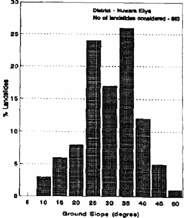
Figure 1 Variation of landslide frequency with ground slopes
| Slope Range | Assigned Slope Class | Relative weighting based on | ||
| Degree | % | Field observations | Theoretical curve | |
| > 40° | > 84° | 1 | 5 | 25 |
| 31°-40° | 60°-84° | 2 | 15 | 16 |
| 17°-31° | 30°-60° | 3 | 25 | 13 |
| 11°-17° | 20°-30° | 4 | 20 | 7 |
| 0°-11° | 0°-20° | 5 | 10 | 5 |
Criteria for Relative Ranking:
The following six criteria were used to study the nexus between observed landslides and slope classes.
1. Criterion 1 (C1)
| C1 = | Number of Landslides in al
Map Unit (Nu)
---------------------------------------------------- Area of that Map Unit (Au) |
2. Criterion 2 (C2)
| C2 = | Area of Landslides in a
Unit (Au)
--------------------------------------------- Area of that Map Unit (Au) |
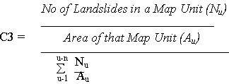
3. Criterion 3 (C3)
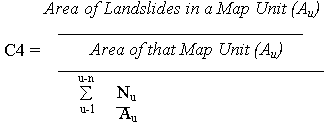
4. Criterion 4 (C4)
5. Criterion 5 (C5)
| C5 = | No of Landslides in a Map
Unit
(Nu) ----------------------------------------- Total No. of Landslides (Nu) ------------------------------------------ Area of Landslides in a Map Unit (Au) ------------------------------------------ Total No. of Landslides (au) |
This could be easily done, because the available maps were on a digitized form, and ARCINFO software was eminently suitable.
Hazard Potential Index :
The hazard potential indices H1, H2, H3, H4, H5 and H6 for different slope classes were computed as defined below. Same data when analyzed using all the six criteria would yield hazard potential as shown in Fig. 2.
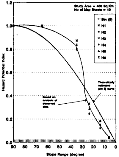
Figure 2 Index of hazard potential based on analysis of observed data and theoretically estimated (sin 0) curve
| H1 = | Value of Criterion 1 (C1) for the slope
class ------------------------------------------- Value of Criterion 1 (C1) for the slope class1 |
| H2 = | Value of Criterion 2 (C2) for the slope
class ------------------------------------------- Value of Criterion 2 (C2) for the slope class1 |
| H3 = | Value of Criterion 3 (C3) for the slope
class ------------------------------------------- Value of Criterion 3 (C3) for the slope class1 |
| H4 = | Value of Criterion 4 (C4) for the slope
class ------------------------------------------- Value of Criterion 4 (C4) for the slope class1 |
| H5 = | Value of Criterion 5 (C5) for the slope
class ------------------------------------------- Value of Criterion 5 (C5) for the slope class1 |
| H6 = | Value of Criterion 6 (C6) for the slope
class ------------------------------------------- Value of Criterion 6 (C6) for the slope class1 |
The results clearly show that the overly of landslide inventory map on a slope map yield higher hazard potential for slope range between 30o -90o when compared to the theoretical values, and the reverse is the case for slope value below 30o.
Discussion
The question therefore arose if the observed trend and its variance with the theoretically estimated values were because of the limited population of data. The studies were continued to cover larger areas. The results are summarized in Fig. 3.
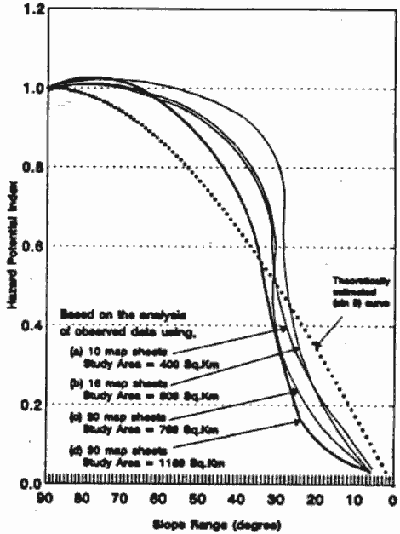
Figure 3 Index of hazard potential based on analysis of observed data and theoretically estimated (sin 0) curve
It is abundantly clear from the figure that increasing population of data provides better correspondence between the observed hazard potential index and the theoretical values, when slope angle is greater than 40o. Below slope angle or 40o the variance was found to be higher
It is quite possible that when the mapping continues on the cover the entire 12,000 sq. km of the hilly region emerge. In the mean time, it was considered prudent to go by the theoretically estimated values because it became absolutely clear that the observed landslides did reflect the combined effect of all the various causative factors, and not of just the slope angle along. Therefore, it would not be appropriate to rely too heavily on the observed behavior, without providing satisfactory explanation for the trend.
Impact on the Overall Hazard Potential:
The next step was to rework the landslide hazard maps using relative weightings based on the theoretically assigned weightings, (Table 1). A much better co-relation was found between the landslide inventory map and the map of inferred instability map obtained by integration of factor maps.
Conclusion:
The paper leads to the following concluding remarks.
- landslide hazard mapping based on integration of the factor maps demand that relative weightless are five to major causative factors as well s to sub-factors. These are usually done based on super position of factors maps on landslide inventory map. In the case of landslide hazard maps for Sri Lanka, it has been observed that relative weightings assigned to different slope classes based on field observations provide poorer convergence between the observed and inferred slope failure potential. On the other hand, if the relative weightings are based on theoretically estimated values, a better convergence is obtain.
- With increasing population of data, it appears that the co-relation between the observed and theoretical weightings improves. Whereas the improvement is marked above slope angle of 40o, it is unremarkable below this value of slope. The explanation to this behavior may perhaps lie in the analysis of greater population of data, when such data become available.
- It is recommended that the relative weightings of the different slope classes be decided on theoretical basis till such time results of large population of field data from landslide sites become available. The Sri Lankan mapping programme covering 1200 sq km of area supports this view.
The authors would like to thank Mr. M.P.K. Perera, Head of the Computer Division at the NBRO, for providing necessary software facilities, and MR. D.M.L. Bandara of the same Division for his support in preparation of this paper.