| GISdevelopment.net ---> AARS ---> ACRS 1996 ---> Agriculture / Soil |
The use of Remote Sensing
Data for Identifying Development of Sugarcane in Buttala Area
P.A.P. Guruge
Centre for Remote Sensing
Survey Department of Sri Lanka
Abstract Centre for Remote Sensing
Survey Department of Sri Lanka
Sugarcane has developed in to a major Land use in Sri Lanka during the last two decades. Survey Department of Sri Lanka previously identified this land use category using aerial photographs. The minor nature of distribution of sugarcane, leads to misidentification with other similar land use categories, as evidence in the 1:50,000 topographic sheets and 1:100,000 land use maps.
Cultivation of sugarcane is rapidly increasing in the Buttala area in the South-East region of Sri Lanka. Satelite Remote Sensing produce an easy and effective techniques to monitor the sugar area changes and to predict the harvest.
This paper presents the development of sugarcane in the Buttala area from 1983 to 1994 and discuss the use of IRS imagery for the monitoring.
1.0 Introduction
Use of Remote Sensing Techniques have been developed in all over the world during the recent past in estimation of expansion and prediction of potential crop yield for specific crops distributed in large areas. This method is very effective over traditional method as far as cost of operation and the timeliness is concerned.
Sugarcane is mostly grown as an irrigated annual crop in the study area. It is rapidly developing crop in Sri Lanka specially during the last two decades. Therefore monitoring the development of sugarcane production and prediction of harvest is rather important.
This exercise consists of two stages. Monitoring the development and distribution of sugarcane in Buttala area in the initial stage. This also comprises of a preparation of a digital map indicating the increase in extent of cultivation within last decade. The next stage is the collection of actual crop yield in selected farm plots to be used in the final calculation of estimation of harvest.
2.0 Study Area
The study area is selected from Buttala area and its extent is about 500 km2. This area is situated between 6o46'-6o33' Northern latitudes and 81o8' -81o18' Eastern longitudes in Monaragala District. (figure 1.0). The area falls in to the agroecological zone of DL1 (Dry Zone Low Country) with an annual rainfall 1000-2000 mm and mean temperature about 25o-27oC. Reddish Brown Earth is the prominent great soil group in uplands and low Humic Gley Soils cover the lowlands of the study area.
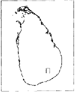
Figure 1.0
3.0 Methodology
3.1 Materials
For the identification of sugarcane cultivation areas aerial photographs were used for the period of 1983, 1988 and 1994. In 1992 IRS image was used for this purpose.
3.2 Area Estimation
The identified sugarcane areas from aerial photograph and IRS were used as base material to prepare a digital map of 1:50,000 scale. Sugarcane areas were computed using digital images for four years 1983, 1988, 1992 and 1994 respectively. In each stage increase in sugarcane areas were determined.
3.3 Yield Estimation
In estimation of sugarcane harvest, few farm plots were selected within study area and actual yield data were collected for few consecutive years. The harvest was calculated using crop coverage and the average yield collected over past few years.
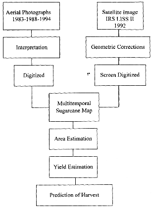
Figure 2.0 Framework for methodology
4.0 Results
4.1 Area Estimation
The extent of sugarcane cultivation in different periods considered are shown in the table 1.0 given below.
| Years | Source | Area (ha) | Increase |
| 1983 | Air photos | Very small | - |
| 1988/89 | - do - | 5215 | 5000 (approx.) |
| 1991/92 | IRS | 8925 | 3710 |
| 1994/95 | Air photos | 9770 | 845 |
The distribution and expansion of sugarcane during these dour years is shown in a map of scale 1:275000 (figure. 3.0)
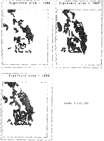
Figure 3.0
4.2 Yield Estimation
Yield estimation was done according to the following table
| Years | Cultivation area (ha) | Estimated Yield(ton/ha) | Estimated Production(m.ton) |
| 1988/89 | 5215 | 60 | 312,900 |
| 1991/92 | 8925 | 67 | 597,975 |
| 1994/95 | 9770 | 70 | 683,900 |
5. Discussion
The areas estimated in different years using aerial photographs and IRS data could not be compared with the available data from Pelwatte Sugar Industries Ltd., as the total extent of cultivation was not availabe.
The main aim of this study was to monitor the changes of sugarcane cultivated areas. It is quite evident that the sugarcane areas have increased very rapidly during last decade. For this reason it is separated from other crops as in earlier classification and considered as a separate category for present Land Use Mapping.
This exercise can also be utilized to predict harvest under normal irrigated conditions. In doing so one has to separate the vegetative stages of sugarcane from the mature stages. Combining this information with few field investigation it is possible to predict harvest within agreeable limits.
References
- The National Atlas of Sri Lanka
- Agrometerological crop monitoring and forecasing by M.Frere and G.F.Popov, Food and Agriculture Organization of the United Nations, Rome.