| GISdevelopment.net ---> AARS ---> ACRS 1995 ---> Spatial Information Processing |
Plan of the Construction of
GIS for Northeast Thailand
Yasuharu Yamada*, Mitsuo
Suzuki*, Wapakom Amorndham**, Somsak Sukjarn***
Japan Intemational Research Center for Agricultural Sciences(JIRCAS)*
1-2 Ohwashi, Tsukuba, Ibaraki, 305 Japan
Agricultural Development Research Center in Northeast Thailand(ADRC) **
Mae Din Daeng, Khan Kaen 40000, Thailand
Soil Survey and Land Classification Division, Land Development Department(LDD) ***
Mae Din Daeng, Khan Kaen 40000, Thailand
Abstract Japan Intemational Research Center for Agricultural Sciences(JIRCAS)*
1-2 Ohwashi, Tsukuba, Ibaraki, 305 Japan
Agricultural Development Research Center in Northeast Thailand(ADRC) **
Mae Din Daeng, Khan Kaen 40000, Thailand
Soil Survey and Land Classification Division, Land Development Department(LDD) ***
Mae Din Daeng, Khan Kaen 40000, Thailand
JIRCAS has a started comprehensive study on sustainable agricultural systems with Thai agricultural organizations in the northeast Thailand from this year. Agriculture of the region is faced with diverse problems associated with environmental degradation. It will be very important to evaluate the potential agricultural productivity to design suitable agricultural landuse system in this region. We reviewed 3 papers to construct a GIS to create maps by using GIS and a remote sensing technique.
1 Introduction
Two years ago, JIRCAS (formally Tropical Agricultural Research Center) has established to extend intematinally collaborating research activities. The activities includes;
- Evaluation and improvement of agriculture-forestry-animal husbandry-fisheries combined farming systems in the Mekong Delta(Vietnam)
- Comprehensive study on sustainable agricultural system in Northeast Thailand
- Productivity and Sustainable Utilization of Brackish Water Mangrove Ecosystems(Malaysia) .(China)
- (Planning: Brazil)
Northeast Thailand is one of the major target areas of the agricultural development. The development of a sound sustainable agricultural systems is urgently needed for Northeast Thailand. Such studies will contribute to the agricultural development of other developing countries which have common environmental and agricultural problems. This project is expected to pave a way for an establishment of intemational collaborative research on sustainable agricultural development in environmentally vulnerable areas in the tropics.
Objective: This project aims to develop sustainable farming systems in environmentally vulnerable areas in Thailand by identifying agricultural technologies of crop and livestock production which are readily transferable to local farmers.
More specific objectives of this project are: 1) to evaluate environmental and biological resources in the area and to develop more effective uses of those resources, 2) to develop sustainable cropping systems in lowland and upland areas With emphasis placed on soil and water conservation and to develop postharvest technologies for local agricultural products, and 3) to improve livestock production technologies with locally available feed resources to promote mixed farming systems.
Project Implementation: (tentative outline)
- Inventory and evaluation of agro-environmental and agro-biological
resources
- Agro-environmental resources: climatic factors, water and soil resources
- Agro-biological resources: crops, livestock, and microorganisms
- Possibilities of more effective uses of existing resources
- Systematization of regional information (GIS)
- Development of sustainable agricultural systems
- Intensive paddy cropping systems with tank irrigation
- Sustainable upland farming systems with crop rotation
- Improvement of livestock production with locally available feed
resources
- Forage crop management
- Livestock production with local feed resources
- Sustainable mixed farming systems
- Development of postharvest technologies for local agricultural
products
- Postharvest technologies to minimize postharvest losses
- Quality improvement and food processing
- Economic evaluation of mixed, multiple-cropping agricultural systems
- Management evaluation of farming systems with tank irrigation
- Evaluation of various types of mixed farming
- Economic evaluation of regional agriculture
Thailand: Department of Agriculture (DOA), Department of Livestock Development (DLD), Agricultural Development Research Center in Northeast (ADRC), Khon Kaen University (KKU), Department of Land Development (LDD), [Asian Institute of Technology (AIT), Kasetsart University(KU)].
Japan: National Agriculture Research Center (NARC), National Institute of Agrobiological Resources (NIAR), National Institute of Animal Industry (NIAI), National Grassland Research Institute (NGRI), National Research Institute of Agricultural Engineering (NRIAE), National Research Institute of Agricultural Economics (NRIAE), National Food Research Institute (NFRI).
Duration: 7 years from April 1995 to March 2001
3 Previous studies using GIS and Remote sensing in Thailand
Following 3 papers are the previous studies related to our plan. The authors found out some helpful points for a future plan.
"Utilization of the Geographical Information System in North-East Thailand"
GIS is a useful method for evaluating land suitability and yield prediction based on information concerning land resources such as soil, topography, climate, land use and so on. The objectives of this investigation are to develop a geographical database for Northeast Thailand using PAMAP (GIS installed at ADRC) to evaluate the suitability of paddy rice production of the Kohn Kaen Province.
Basemaps were prepared to digitize it at a scale of 1/250,000, namely maps showing soil classification, soil salinity, landuse, boundaries, rivers and roads.
By selecting the factors related to cultivation and rating, an equation indicating for suitability for paddy rice was developed. Selected factors were consolidated layer, soil texture, permeability, nutrient status, salinity, slope topography and rockiness. Based on the limitation of cultivation for paddy rice, these factors were classified into five ranks (Table.1; rank of limitation is P-1 < P-5) and overlaid to generate polygons with suitability .
| Limition | P-1 | P-II | P-III | P-IV | P-V | Data Source |
| Consolidated Layer : C | none | none | between 25-50 crr | between 15-25 cm. | deeper than 15 cm. | Soil Map |
| Texture : T | C, SC, SIC, CL, SICL | L, SCL, SiL | SL | S LS Sl | Soil Map | |
| Organic Layer : O | none | none | none | found in surface, thick 20-40 c | found in surface, thick > 40 c | none in NE. |
| Gravels : G | none | none | gravel | gravel | gravel | Soil Map |
| Permeabllity : P | medium | repid | Soil Map | |||
| Nutrient status :
N |
low | low | low | low | Soil Map | |
| Jarosite : J | none | none | In 40-100cm. depth | In<cm. depth or pH<4 | none in NE. | |
| Salinity | class 6 | class 6 | class 4 | class 3 | class 1.2 | Salin Soil Map |
| Risk of Water shortage : W | slightly risk | moderatly risk | very risk | too risk, plant con't survive in cropping season | Rain Fall Data | |
| Topography of Slape : T | flat | flat | flat-undulating | undulating-undulating-rolling | undulating-hilly, rolling, rolling-hilly, hilly, hilly-steep, steep | Soil Map |
| Rockiness or Stones : R | RL | Soil Map | ||||
| Flood Hazard : F | occur 1-3 times in 10 years | occur 4-6 times in | occur 7-9 times in 10 years | occur every year | none in NE. |
A suitability map of paddy rice (Fig.5; rank of suitability is 8-1 > 8-5) was made as a result of their evaluation. Suitable land (8-1 and 8-2) was found to be limited in Kohn Kaen Province. The major problems of unsuitable areas (&4 and 8-5) were slope topography, permeability and salinity. In these areas, it is necessary to shift to other crop production and to adopt some techniques for improvement. These way were in evaluating the sustainable rice production; Approach 1 consists of generating polygons by overlaying some related layers. This approach was utilized in this study. Approach 2 and Approach 3 are ways to evaluate based on the ranking of estimated yields. In Approach 2, yield estimation models are made based on cultivation experiments. Models with Approach 3, statistical methods are used to survey data which yield criterion variables and environmental features are analyzed as predictor variables. Therefore, many sampling points are needed for this Approach.
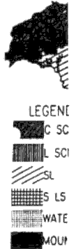
Figure 1 Texture Boundaries Khonkaen Province
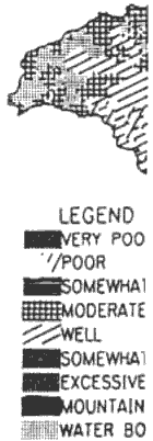
Figure 2 Permeability Boundaries Khonkaen Province
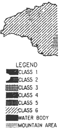
Figure 3 Soil Salinity Khonkaen Province
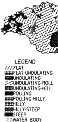
Figure 4 Topography Boundaries Khonkaen Province
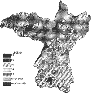
Figure 5 Suitability Map Khonkaen Province
"Agricultural landuse classification using remote sensing and Geographic Information in the Central Plain of Thailand"
Geographic Information System (GIS) has many advantages such as overlay between map data and remote sensing data, buffering, network analysis, etc. As agricultural landuse spread out on a plane, the management of various information about agriculture is easy and efficient in case of dealing with plane. y AMAOA submitted a sample analysis using minute topography information in the Central Plain of Thailand. The obtained results were combined with the results from remote sensing analysis using LANDSAT data.
His final result of analysis shows (1) The drainage of farm land on the natural levee after rainy 1\ season is very good and vegetation exists even in dry season; the landuse maybe is orchard. (2) At the f area, where the inundation has relatively short stay, in the Central Plain of the production area of floating I rice, the harvest is earlier than the other places: To reap rice is over at the beginning of the dry season. The gradation of the height of topographical features just agrees with the amount of biomass estimated by the vegetation index (VI) calculated from LANOSA T TM and MSS data when to reap rice. (3) At the western part of the Central Plain, the region is not flooded except for extraordinary inundation. Sugarcane is widely cultivated in the area.
"Land Evaluation for Agricultural Productivity in North-East Thailand Using Landsat TM Data and Geographic Information"
In the north-east Thailand, there are many paddy fields and other annual crop fields. The size of farmland is not so large as that of the Central Plain. There is a big problem of soil salification which . caused by the unbalance of precipitation and evapo-transpiration. It is one of primary target to detect the : salt damaged areas using satellite data.
An agricultural landuse classification for using Landsat TM data in this region collected in a dry season and a wet season is proposed by Dr. SAITO et al. He proposed a map of potential agricultural productivity .
(1) Landuse map
Landuse map is made from the changes in Landsat images of rainy season and dry season. After that, the extraction of salinization area, paddy field and upland field is held from the map.
(2) Normalized vegetation index (NVI) map
NVI is calculated by the following expression.
Average and difference NVI maps were computed with dry season and wet season data. VCR, KVI are proposed and similar average/deference maps are made.
(3) Digital soil fertility map and digital topography map
Those maps are digitized from soil map and topography map.
After preparation (1) to (3), each map is weighted and overlaid by evaluation of paddy field and upland field suitability on GIS. The map of potential agricultural productivity is created. In this report, to weight the maps is experiencely done by researcher Findings
In Northeast Thailand, both precipitation and soil salinity are considered major restriction factor for agriculture. t
GIS is useful as a mapping system and a database management system, but the development or t construction of these digital information system has several problems such as accuracy, format, data entry, data management and data transference to other GIS software at other organization.
Remote sensing is a useful method to obtain real time information about land cover change; The data exchange between remotely sensed data and GIS data will play important role.
4 Future plan and conclusions
(1) Construction of geographical database of land resource information in Northeast Thailand is at the preliminatry stage. For example, soil maps, salinity distribution maps, soil erosion maps, some kinds of landuse maps, etc are demanded.
(2) We plan to create a potential agricultural productivity map and a suitable agricultural landuse evaluation map from the existing information.
GIS system is very powerful and useful tool for recognizing agricultural landuse. It will be convenient that geographic data such as topography, soil map, etc. and ground truth data are managed by GIS. Furthermore, there is a good possibility that satellite remote sensing data can update to geographic information data. Because satellite data can obtain periodically.
There are several problems of how to weight maps theoretically and quantitatively, how to verify the potential productivity map.
It will require stable organization to conduct data entry, management for land resource information and to upgrade GIS data.
Acknowledgments:
The report of "Utilization of the Geographical Information System" was the work of Dr. Kenji Matsumori (National Institute for Agro-Environmental Sciences in Japan), Dr. Wapakorn Amorndham (ADRC) and Dr. Somsak Sukjarn (Land Development Department in Thailand), operated by Japan International Cooperation Agency (JICA) cooperative research project with ADRC.
The report of "Land Evaluation of Agricultural Productivity in Thailand using Remote sensing Techniques" is one of the results of the joint research project on the enhancement and application of the remote sensing technique between ASEAN countries and Japan supported by Science and Technology Agency (STA) of Japan. Dr. Genya Saito, Dr. Tsuyoshi Akiyama, Mr. Yasuharu Yamada, Mr. Yoshiki Yamagata and Mr. Nobuyuki Mino are joint researchers for Japanese side; Mr. Pongpit Piyaponse and Ms. Ekkanit Hansakdi are Thailand side researchers.
References:
- Genya Saito, Yasuharu Yamada, Yoshiki Yamagata, Tsuyoshi Akiyama, Michio Shibayama, Shinsuke Mirinaga, "Evaluation of Agricultural Productivity in Thailand using Remote sensing techniques", Technical Report of Joint Research on the Enhancement and Application of the Remote Sensing Technology with Asian Countries and Japan, 119-141, 1991
- Genya Saito, Tsuyoshi Akiyama, Yasuharu Yamada, Nobuyuki Mino, "Evaluation of potential agricultural productivity using LANDSA T TM and GIS in Northeast Thailand", Journal of the Japanese Agricultural Systems Society, 10, 1, 1-10, 1994. (in Japanese)
- Kenji Matsumori, Wapakorn Amorndham, Sornsak Sukjam, "Utilization of the Geographical Information System", Report of Short Term Expert of Japan Intemational Cooperative Agency (JICA), 1995
- Yasuharu Yamada, "Agriculturallanduse classification using remote sensing and Geographic Information in the Central Plain of Thailand ", Proceedings of the annual meeting of Japanese Society of Irrigation Drainage and Reclamation Engineering, 18-19, 1991 (in Japanese)