| GISdevelopment.net ---> AARS ---> ACRS 1995 ---> Water/Marine Resources |
Weather Forecast and Plankton
Bloom Detection using Oceanographic Buoy in the Gulf of Thailand
Dr. Pitan
Singhasaneh
Seawatch Thailand Programme
Remote Sensing Division
National Research Council of Thailand
196 Paholyothin Road, Jatujak, Bangkok 10900, Thailand
Abstract
Seawatch Thailand Programme
Remote Sensing Division
National Research Council of Thailand
196 Paholyothin Road, Jatujak, Bangkok 10900, Thailand
Seawatch Thailand is a complete marine environmental monitoring and forecasting system which integrates data collection, data analysis, environmental modeling and forecasting with an advanced computerized system for distribution of marine information and forecasts to interested operators and/or authorities. The data measured from the programme can be effectively used in the forecasting of weather and the detection of plankton bloom. The combination of buoy data with satellite data and air survey yields an increase of effectiveness in the weather forecast and plankton bloom detection.
1.0 Introduction
Seawatch Thailand is a complete marine environmental monitoring and forecasting system which integrates data collection, data analysis, environmental modeling and forecasting with an advanced computerized system for distribution of marine information and forecasts to interested operators and/jor authorities. The project is being implemented under close co-operation between the National Research Council of Thailand (NRCT) OCEANOR, the oceanographic company of Norway, and other involving parties, including the Harbour Department, the Meteorol9ogical Department, Port Authority of Thailand Naval Hydrographic Department, Department of Fisheries, the Petroleum Authority of Thailand, Marine Police Division, Chulalongkorn University, Kasetsart University, Prince of Songkla University, Burapha University, etc.
2.0 Programme Objectives
2.1 To set a marine database using technological integration of remote sensing, buoy network, and meteorology.
2.2 To archive and distribute marine data and information to involving agencies both in governmental and private sectors to be used in national resources development and management.
2.3 To coordinate and work with other organizations in the studies and researches in the field of oceanography and marine resources.
2.4 To coordinate and work with involving agencies in the utilization of marine data and information in nation resources planning, development, preservation.
3.0 Programme Activities
3.1 Data Acquisition A real time data covering is provided by a network of moored data buoys (called TOBIS buoys), which includes meteorological parameters (wind speed & direction, air temperature & pressure) and oceanographic parameters (oxygen/nutrient contents, light attenuation, waves, currents, temperature/salinity profile, radioactivity). The buoys have also their own data logging equipment, on-board processing (for data analysis & quality control), and a transmission system. The collected data are then transmitted to a shore station through the ARGOS satellite communication system on NOAA.
3.2 Data Storage, Analysis and Presentation The data is processed and stored in the database in time series format. The data can be re-presented in the form of tables of graphics.
3.3 Environmental Modeling and Forecasting A number of numerical modeling and forecasting software have been developed under the programme, including HYBOS, NOMAD, OILSPILL, OILSTAT.
3.4 Data/Forecasts/Users-Relevant Information Distribution An information system or "Thainet" allows users to have easy access to the various data collected and other derived information including the forecasts on a near real-time basis via PC terminals.
4.0 Weather Forecast
Buoy data has been used by the Meteorological Department for the weather forecast. The buoy network provides valuable meteorological data (wind speed, wind direction, air pressure, air temperature) and oceanographical data (wave height & period, current water temperature) on the near-real-time basis. The in-situ measurements from the buoy network and the data from meteorological satellite are the indispensable tools for the weather forecast in the Gulf of Thailand.
October 1994 plots of Plathong buoy are shown here to demonstrate the buoy ability to detect changes in weather and sea-state. The meteorological weather chart of the Weather \Forecast Division Meteorological Department is also included for the data comparison.
5.0 Plankton Bloom Detection
Rate of occurrences of plankton bloom has been increasing in recent years in the Gulf of Thailand. Two species of blue-green algae; Trichodesmium erythraeum (Her. Ex Gomont) and Trichodesmium thiebautii (Gomont ex Gomont) Geitler, and Noctiluca miliaris; are found to be the cause of sea water discoloration. Blooms are also frequently seen in the vicinity of estuarine area showing the colors of red, green, yellow, and brown.
Some of the sensors on the buoy can indicate the development of the algal bloom by the detection of changes of sea water light attenuation and dissolved oxygen. The light attenuation and dissolved oxygen values are shown in this paper together with the flight report from the Planning Division, Department of Industrial Work. Easily seen from the plots, the level of light attenuation increase and the dissolved oxygen values show greater fluctuations during the bloom development.
6.0 Conclusion
The Seawatch Thailand programme is established through networking of data collection buoys. The measured parameters can be effectively used in the forecasting of weather and the detection of algal bloom. The combination of buoy data and air survey (and possibly satellite data) yields the increase of effectiveness in both areas.
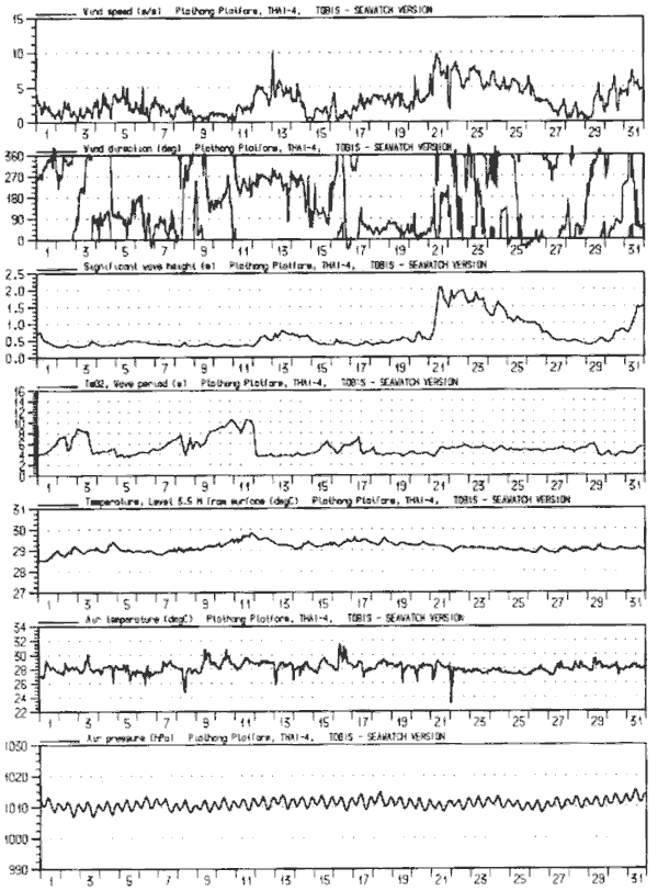
Figure 1: Plots from plathong Buoy in the middle of the Gulf of Thailand) in October 1994. Consisting of Air Temperature, Air Pressure, Wind Speed, Wind Direction, Water Temperature Wave Height, and Wave Period.
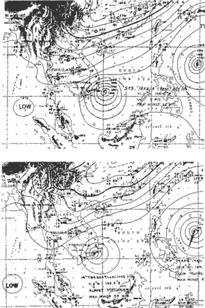
Figure 2: Weather Chart, obtained from Meteorological Department, Ministry of Transport and Communications Thailand. The first chart is dated Tuesday 25 October 1994 at 0700 local time The second Chart was dated Wednesday 26 October 1995 at 0700 local time.
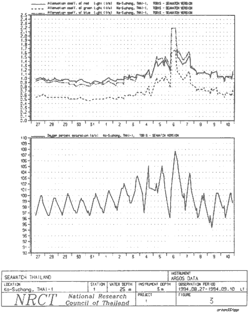
Figure 3:Plot of Sichang Buoy (near Sichang Island) showing Blue, Green, and Red Attenuation and Dissolved Oxygen Content. The plot was taken from the period of 27 August 1994 to 10 September 1994.
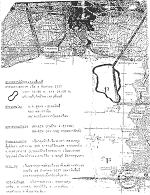
Figure 4 Air survey map of 4 September 1994 at 1050 and 1410 from planning Division, department of industrial work, showing the area, which was effected by algae bloom. The survey was performed by the aircraft. The bloom was green / black in color, covering approximately 300square Kilometer from the mouth of chophaya river to north of sichang island