| GISdevelopment.net ---> AARS ---> ACRS 1995 ---> Education & Trainning |
Cartographic Information
Analysis: a Case Study as an aid to teaching
R. Sudarshana, S.
Sebastian*, and S. K. Bhan
Indian Institute of Remote Sensing, 4, Kalidas Road,
Dehradun - 248 001, India
*Society of Management Science and Applied Cybernetics.
C/o International Management Institute
B10/30-31, Qutab Institutional Area, New Delhi -110016, INDIA.
AbstractIndian Institute of Remote Sensing, 4, Kalidas Road,
Dehradun - 248 001, India
*Society of Management Science and Applied Cybernetics.
C/o International Management Institute
B10/30-31, Qutab Institutional Area, New Delhi -110016, INDIA.
A digital Evevation Model (DEM) was created for a small geographic area on the personal computer subsequent to digitising the elevation from a map of 1:1000 image scale. The DEM was transformed into a rester of single band image. and several overlays of utilities and features were created as boundary files to be covered on the DEM. Several combination of the overlay considerations have been analysed and presented. In addition, case was taken to manage the data files in a way that suits the needs of imparting training in Geographic Information System (GIS). Several tutorial schedules that could be adopted for teaching are suggested and it is hoped that the emulation of this example would came a long way in the transfer of a technology which is fast emerging and is calling for attention.
Introduction
Development of spatial resources require an in-depth analysis of the existing units within a definitive geographic boundary in terms of location, quality and quantity. Further, the interrelationships of these units in providing useful solutions to the problems of space and resource use are of immense importance in explains the optimal behavior of geographic features. In the conventional scientific education, this situation is simulated by studying various academic disciplines initially and considering a multidisciplinary condition at the decision making level. But in the recent time technology has enabled us to consider the features as segregated layers of information which may be computed in various ways to indicate natural processes. The later ability is termed popularly as geographic information systems (GIS) suggesting an arrangement of systems analysis of various information, processing compatible geography.
Hence, the term geographic information analysis' broadly includes the capability of compiling, formatting, storing, manipulating and retrieving information of defined geographic enclosures for the benefit t of optional development of spatial resources. In the present context too, it has been envisaged to collect and collate diverse information in the ambit of their geography.
Moreover, realising the need of evolving case studies as an aid in teaching, the example has been organised into a set of modules of information and suggestions on how to develop curricular schedules around them are provide .The case study has already been adopted as a teaching aid and is found to be of interest amongst scientific workers.
Data Synthesis and Analysis Features of Study Area :
The study was conducted for the campus of Indian Institute of Remote Sensing (IIRS), Dehradun which covers an area of about 20.9 acres. This small parcel of land is a segregated geographic entity in the sense that most of it forms a plateau which is surrounded by sharp slopes and deep valleys on three sides. Out of the 20.9 acres, nearly half lies on slope and valleys for the purpose of study, same portions of surrounding area were also included and the total range of altitude in the area was from 665.5 m to 699.5 m above chart Datum.
Compilation of Basic Data and Generation of Digital Elevation Model (DEM)
Basic source of data was the recently prepared map of campus region in the scale of 1:1000. A close grid was overlaid on the map and 982 points were sampled from grid intersections for elevation data. This intense sampling at very close interval provided a very real representation of the terrain of the region. The X, Y (map co-ordinates) and Z (elevation) data from all the 982 points were arranged in a LOTUS-spread sheet format and further subjected to interpolation on a personal computer using the following model.
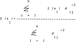
where,
Z = elevation in meters
X = points at which surface is to be interpolate j
d= distance from the reference point to the point to be interpolated.
The above model follows the logic of weighted moving average or inverse squared distance weighting (Burrough, 1990) based on the argument that observations located close together tend to be more alike than observations spaced further apart. For the interpolation, a size of 250 (x) and 210 (y) was considered with a search radius of 20.6155281 and 10 nearest plaints. The inherent cell size was 0.177 meters in both x and y directions. The resultant grid raster was of the size of 52,500 elements and it seemed as the DEM for IIRS campus region. A contour plot of this DEM is shown as Fig. 1 and a perspective surface plot is given as Fig. 2.
Image Generation from DEM
The grid raster of interpolated DEM was reorganised and formated into a raster image of 210 lines and 250 columns. The image became akin to a single band satellite image and was provided with a header information on cell size, latitude centre, projection etc. enabling it to accept polygon overlays later. This DEM image was monitored on Image Display Analysis (IDA), (FEWS, 1989) on a personal computer. The image header details are provided in Table 1, while the image of DEM is shown in Fig. 3.
| Title: Image of The DTM of Indian Institute of Remote Sensing | ||
| Image type code | 0 | Generic |
| Projection | 3 | Platee Carre |
| Height | 210 | |
| Width | 250 | |
| Lat-center | 19.50000 | |
| Long-center | 26.00000 | |
| X-center | 125.00000 | |
| V-center | 105.00000 | |
| DX | 0.1760000000 | |
| DY | 0.1761904762 | |
Generation of Overlays and perspective viewing
The formation of the image of DEM of IIRS campus with a header providing definitive geographic position of each pixel opened up the possibility of overlaying feature boundaries within the image frame. Making use of this, a number of boundary files were created on the grid with the help of sources like engineering drawings and field work. The overlay files had a very simple structure of co-ordinate listing. The overlays were lines and polygons, depending on the feature and one line header for each vector was maintained. This header consisted of two values, the first being the vector attribute and the second being vector size in terms of number of points. The overlays could be called one after the other and superimposed on image of DEM on IDA. The simple structure of image and its overlays provided possibility of considering the features in various combinations. The layouts of various overlays in combination are given in Figs. 4 to 9. Further, the vectors of landuse were also generated containing information on lawns, groves, gardens etc. and a choropleth formation 0£ each feature vector provided a comprehensive layout as shown in Fig. 10. Once the choropleth images were developed, several choropleths were pooled in one file and the whole was overlaid on the DEM in perspective using IDRISI on personal computer. This perspective is given as Fig. 10. The percent occupation of each vector in the campus is also shown in Table 2.
| Feature Polygon | no. Of Pixels | area | proportion | |||
| in sq.ft | in sq.ft | in acres | % of Plateau | % of Total | ||
| Offices | 1401 | 36823.37 | 3420.99 | 0.8453 | 8.21 | 4.04 |
| Residences | 599 | 15743.90 | 1462.65 | 0.3614 | 3.51 | 1.73 |
| Hostels | 396 | 10408.32 | 966.96 | 0.2389 | 2.32 | 1.14 |
| Lawns | 811 | 21316.03 | 1980.32 | 0.4893 | 4.75 | 2.34 |
| Groves | 617 | 16217.00 | 1506.60 | 0.3722 | 3.62 | 1.78 |
| Plantations | 415 | 10907.71 | 1013.35 | 0.2504 | 2.43 | 1.20 |
| Kitchen Gardens | 671 | 17636.32 | 1638.46 | 0.4048 | 3.93 | 1.94 |
| Gardens | 537 | 14114.31 | 1311.26 | 0.3240 | 3.15 | 1.55 |
| Roads | 530 | 13930.33 | 1294.16 | 0.3197 | 3.10 | 1.53 |
| Total Landuse | 5977 | 157097.29 | 14594.75 | 3.61 | 35.02 | 17.25 |
| Total campus on Plateau | 17070 | 448668.00 | 41682.54 | 10.3 | - | 49.28 |
| on Ravines | 17567 | 461736.00 | 42896.60 | 10.6 | - | 50.72 |
| Grand Tot. | 34637 | 910404.00 | 84579.14 | 20.9 | - | 100.00 |
Database as a Training Aid
The database of the IIRS campus has been created with a very simple structure as stated earlier in view of its proposed use as an effective tool in training activities. , While learning GIS at conceptual and technical levels, this example is hoped to serve a multi-disciplinary clientele. Before appraising of the tutorial pattern that may be followed with the help of database, it would be appropriate to list the overlays that were created, as follows :
| Overlays | Basic Image |
| I. Buildings | 1. Digital Elevation Model |
| 2. Roads | |
| 3. Fence | |
| 4. Water supply | |
| 5. Power supply overhead | |
| 6. Power supply underground | |
| 7. Vegetation | |
| 8. Land morphology | |
| 9. Telephone line | |
| 10. Sewer lines |
Several tutorials could be developed around this database in order to derive various thematic objectives. While the combinations could be many, a few important suggestion as schedule are given in Table 3.
| Theme Concept | Overlays And Output | ||
| Objective | Solution | Graphic Overlays | Numeric Output |
| Layout map | Combination of pemlanent features | Fence, buildings, roads vegetation | Polygon areas |
| Utility map | Indication of supply network with destination | Fence,buildings,water supply, power supply, telephone sewer | length of cables, length of water, pipelines, length of sewer lines |
| Underground utilities | Projection of earth work | Fence, buildings, water supply network, sewer lines, power cables | Length of trenches Redundancy analysis |
| Probable Water Pollution | Indication of sewer proximity to water supply line | Fence, buildings, water supply sewer lines | Number of crossings, distances at grid positions, Length of proximal areas |
| Vegetation Map | Combination of all vegetation classes | Fence, Vegetation | Areas of polygons |
| Development of green areas | Indication of possible areas for lawn , grove etc. development | Fence, buildings, roads vegetation, water supply | Available areas proximal to water supply |
| Space for new buildings | Exploration of DEM for suitable areas | Fence, buildings, roads vegetation, DEM | Position and areas of available flat zones, proximity analysis with power water,sewer lines |
| Soil conservation | Observation of landslide and erosion prone areas | Fence, DEM | Slope positions, Euclidean distance to gradient ratio Total erosion prone area |
| Local Area Network (LAN) of computers | Exploration of optimal path for cable laying | DEM, buildings, power supply, telephone | Positions to avoid power supply crossing Positions to avoid slopes shortest cable distance costing of earth work. |
Conclusion
In all, system analyses such as this have a definite advantage over the conventional means of data synthesis in view of resource development and optimal planning. In the contemporary context, use of these case studies for imparting training in, an organised way is also of utmost importance. The basic inherent advantage of databases like this is that the format is simple and may be created, maintained and augmented at case on a variety of hardware platforms. Being raster in format and changing over to vector only for overlaying, is a definite advantage in view of personal computers that are largely available. Moreover, the database when used as a training aid fulfills the needs of technology transfer and every step of database augmentation would result in updation of tutorial schedules in a way similar to curricular updation. Hence, the scope of experiments such as this is wide and diverse.
References
- Burrough, P.A., 1990. Principles of geographical information systems for land resources assessment. Oxford science pub., Oxford, U.K. pp. 194.
- FEWS, 1989. Image Display and Analysis. Price, Williams and Associates inc., U.S.A. pp. 42.