| GISdevelopment.net ---> AARS ---> ACRS 1995 ---> Poster Session 3 |
Variation of surface Currents
Offshore from Rayong Rivermouth from NRCT Buoy Data in 1994
Absornuda Stripping,
Supichai Tangjaitrong, Sirichai Dharmvanij, Chaiyong Yuangthong and Pakorn
Purimatikant
Marine Science Department, Faculty of Science
Chulalongkom University, Bangkok 10330, Thailand.
Presented at the 16th Asian Conference on Remote Sensing,
20-24 Nov. 1995, at Suranaree University of Technology Nakhon
Ratchasima, Thailand.
Abstract Marine Science Department, Faculty of Science
Chulalongkom University, Bangkok 10330, Thailand.
Presented at the 16th Asian Conference on Remote Sensing,
20-24 Nov. 1995, at Suranaree University of Technology Nakhon
Ratchasima, Thailand.
The monthly current rose data at 3 metre depth, Lat. 120 29' 42" N, Long. 1010 14 '16'' E. in 1994 from the TOBIS buoy, under the SEAWATCH program of the National Research Council of Thailand, at the offshore of the Rayong Rivermouth were analysed with the mean wind data to study the pattern of wind-driven currents. In North monsoon, from October to January, the sea currents mainly flow to 300° from North with the mean speed of 10.65 cm/sec. In South monsoon season, from February to May, the currents principally flow to 120° from North, with the mean speed of 11.775 cm/sec. During the Southwest monsoon season, from June to September, the principal currents flow to 90° (to East), with the mean speed of 12.10 cm/sec.
Introduction
The continuous current date in the sea are important especially for the study on transport of energy and matter, among others. The data from the ship are only discrete and not continuos for a long term study. The National Research Council of Thailand moored 7 Buoys in the Gulf of Thailand under the SEAWATCH program.
Data and Method of Study.
One of the TOBIS buoy of NRCT by the OCEANOR was moored offshore of the Rayong Rivemouth at the Lat. 12 0 29' 42" N, Long. 1010 14' 16 E. The current data at 3 metre depth under the sea surface in 1994 were plotted per month by the software ORKAN to show the current rose method. The data were missing in January, June, July and December 1994. From the climatological data for 1981 to 1994 by the Meteorological Department, at Rayong, Lat. 120 38 N, Long. 1010 21'E were used to study the wind direction and velocity. The sea current data are related to the wind regime to study the variation of surface wind-driven currents here.
Results
Table 1 is the wind speed and direction at each month average from 1981 to 1994 at Rayong s station. The Northerly winds blow during October to January the Southerly winds blow during February to May, and the Southwesterly winds blow during June to September.
| Wind (Knots) | Jan | Feb | Mar | Apr | May | Jun | Jul | Aug | Sep | Oct | Nov | Dec |
| Mean speed | 3.10 | 4.60 | 5.10 | 4.50 | 5.60 | 8.60 | 8.00 | 8.70 | 4.60 | 2.90 | 2.90 | 3.20 |
| Prevailing | N | S | S | S | S | SW | SW | SW | SW | N | N | N |
| Max. speed | 24 | 33 | 30 | 35 | 40 | 45 | 40 | 50 | 35 | 35 | 24 | 24 |
February 1994 (Southerly wind), Fig. 1, the principal surface current flow to 300° form North, and second maxima to 120° with the mean speed of 12.5 cm/s. This month is the transition period from Northerly wind to Southerly wind.
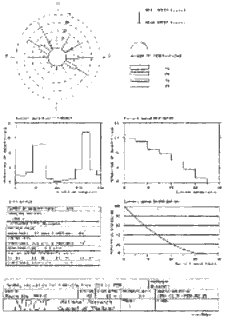
Figure 1
March 1994 (Southerly wind), Fig. 2, the principal surface currents flow to 300° and the second maxima to 120°, with the mean speed of 12.0 cm/s.
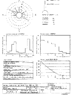
Figure 2
April 1994 ((Southerly wind), Fig. 3, the principal surface currents flow to 300° and the second maxima to 120°, with the mean speed of 11.5 cm/s.
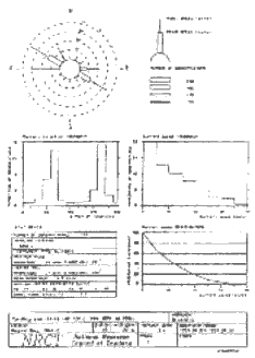
Figure 3
May 1994 (Southerly wind), Fig. 4, the principal surface currents flow to 300° and the second maxima to 120°, with the mean speed of 11.1 cm/s.
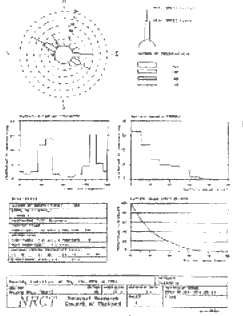
Figure 4
August 1994 (Southerly wind), Fig. 5, the principal surface currents flow to 90° (to North) and the Slower current flow to 330°, with the mean speed of 12.3 cm/s.
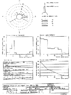
Figure 5
September 1994 ((Southerly wind), Fig. 6, the principal surface currents flow to 90° and the second maxima to 300°, with the mean speed of 11.9 cm/s.
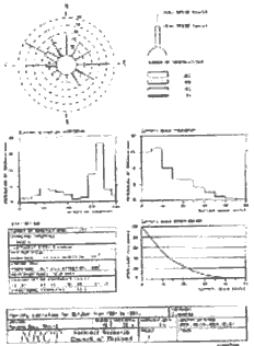
Figure 6
October 1994 (Northerly wind), Fig. 7, the principal surface currents flow to 300° and the second maxima to 90°, with the mean speed of 12.9 cm/s. This month is the transition period from Southwest monsoon to North monsoon season.
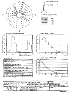
Figure 7
November 1994 (Northerly wind), Fig. 8, the principal surface currents flow to 300° and the second maxima to 120°, with the mean speed of 8.4 cm/s.
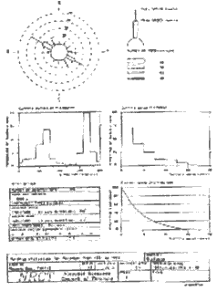
Figure 8
Summary
From the mean wind data (1981-1994) at Rayong,Lat.120 38' N,Long.1010 21'E, the Northerly winds blow from October to January, the Southerly winds blow from February to May, and the southwesterly winds blow from June to September. During North monsoon season (Nov.1994), the principal sea surface currents flow to 300° (from N) and second maxima to 120° with the mean speed of 8.4 cm/s. During the South monsoon season (March to May) the principal sea surface currents flow to 300° and second maxima to 120°, with the mean speed of 11.53 cm/s. During the Southwest monsoon season (August to September), the principal sea surface currents flow to 90° (to N), and the second maxima to 330° (August) and 300° (September), with the mean speed of 12.10 cm/s. In the transition period from N to S monsoon (February), the principal currents flow to 300°, and the second maxima to 120°, with the mean speed of 12.5 cm/s. In the transition period from S to SW monsoon, actually in June, but there is no data in June and July. In the transition period from SW to N monsoon (October), the principal currents flow to 300° and smaller second maxima to 90° (N), with the mean speed of 12.9 cm/s.
Acknowledgements
The authors would like to appreciate the kind assistance of Dr. Darasi Daorueng. Dr. Pithan Singsanae and Ms. Chinoros Booncherm (SEAWATCHTHAILAND,NRCT) for sending the current data from the buoys and Mr. Vattana Kanbua (Meteorological Department) for sending the meteorological data at Rayong.