| GISdevelopment.net ---> AARS ---> ACRS 1995 ---> Poster Session 3 |
An Assessment of Sedimentary
Envionment using IRS-IA Data : A Case Study in ithe Lower Hooghly Estuary,
East Coast of India
Syriac Seeastian And
Amitava Ghosal
Society of Management Science and Applied Cybernetics
C/o International Management Institute
B10/30-31, Qutab Institutional Area
New Delhi - 110 016
India
Abstract Society of Management Science and Applied Cybernetics
C/o International Management Institute
B10/30-31, Qutab Institutional Area
New Delhi - 110 016
India
The present study has been carried out to classify bottom sediment characteristics of Lower Hoogly estury using IRS-IA (LISS-II) digital data in combination with field measurements in concurrence with the IRS-IA overpass. The effect of water depth and bottom sediment on reflectance were also studied by analysis of variance. From the study, it is found that bottom sediment has got significant effect on reflectance. Sandy bottom had the highest mean radiometric reflectance that sandy silt and muddy sand. Mean reflectance for sandy silt and muddy sand did not differ significantly, although both of these bottom types were significantly lower in mean percent reflectance than sandy bottom. Hence, for the accurate estimation of suspended load in the water column, the effect of these factors should be considered.
Introduction
Knowledge of bathymetry and bottom sediment type n the costal sedimentary environment is necessary, because different bottom types commonly exhibit great difference in reflectance. these differences can result incorrect determination of suspended load, and it is necessary to separate or stratify radiometric data into bottom type classes. The strength of the relation between reflectance and concentration of suspended sediment concentration depend on sediment type (Novo Emon et al, 1989). Hence, as accurate estimation of suspended load in the coastal sediment on reflectance. It is important for coastal planners and scientists to know the areal extent of various bottom sediment types for managing and assessing ecosystem that are changing due t o human impacts. Lyzenga et al (1979) carried out mapping for the evaluation of bottom features under variable depth of water. Discrimination of bottom sediment types for coastal region of the northern Dominican Republic were conducted by Luczkovich et al (1993).
In an estuary, the nature and type of bottom sediment vary form place to place. So, and assessment of estuarine sedimentary environment using remote sensing will provide a better knowledge on the bathymetry and bottom features, which in turn expected to be helpful for an accurate estimation of suspended load in the coastal sedimentary environment. The objective of the present study is to understand the effect of bathymetry and bottom sediment type on the reflectance and to classify the bottom type in the lower Hooghly estuary, east coast of India.
Study Area
The Hooghly estuary located in the east coast of India drains the major river complex Bhagirathy-Hooghly. Geographically, the estuary is confined by latitude 210 50' and 220 15' and longitude 870 45' and 880 15' derives most of its upland supply of sediments form the Ganga during the south-west monsoon season. As far as the Hooghly estuary is concerned, the sediment distribution pattern is a typical one, as it is located at the mouth of the major river systems of the world, the Ganges. The sediment discharge along with the river run off into the head of the bay of Bengal follows a seasonal pattern under the tropical climate. The region also experience s high tidal range and strong waves and alongshore flow under the influence of monsoon wind. The offshore region of the estuary extends to distance of 50 miles south of Sagar. The calcutta Bengal, on the Hooghly river. The Hooghly estuary is highly dynamic in terms of suspended load, erosion and deposition resulting problems of safe and assured navigation throughout the year.
Methodology
The sea truth collection was taken in accordance with the IRS-IA overpass in the zones corresponds to 138/45 path and row and 18/53 path and row respectively. The sampling stations are indicated in the figure-1. Total 15 stations extending over an area around Nayachara Island were selected for sea Truth collection. The Syledis System (SR-3) is use4d for fixing the sampling stations in the present study.
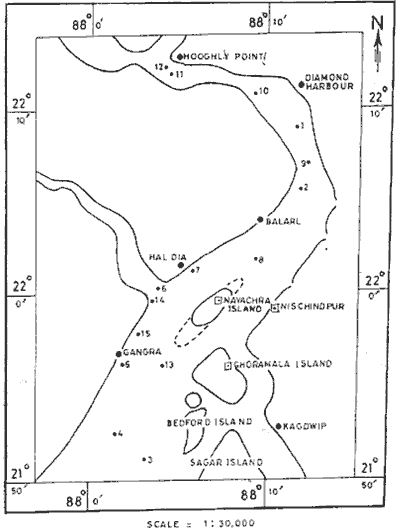
Figure 1 Study Area & Sample Location
Radiometric measurements were made using Exotech Radiometer (041-Optomech Engineers). Reference readings for radiometer were taken with reference to barium Sulphate plate. The radiometer readings were corrected by plotting time versus radiance graph.
Results and Discussion
The textural characteristics of the sediments and given in the table-1. The prodominant type of sediment in the estuary is sand followed by sandy si9lt and muddy sand. It is seen that river inflow and tidal transport mechanism are is seen that river inflow and tidal transport mechanism are effective in carrying the coarse grained sediments to the estuarine area(George et al, 1993). The abundance of sand near river inlet and towards north may be due to input of river distributary, the main source of Hooghly.
The radiometric reflectance and digital numbers (IRS-LISS-IT) for different bottom types under variable depth is given in the table-2.
Bottom Type Classification
Sediments were collected form different parts of the estuary in order to now the bottom sediment type and its effects on reflectance with respect to water depth. Fifteen sediment samples were collected from different depth level varying from 0 to 11.2 meters. From the sediment texture analysis, the samples fall under the category sand, sandy silt and muddy sand. In order to study the effect of water depth and bottom type on reflectance, radiances were measured for certain exposed portion of the land (islands) which are exposed at low tide and submerged in high tide condition. Readings were taken for different bottom types under variable depth. from the study it is found that as the depth increases, the reflectance decreases. For the sandy bottom sediment, Bank-4 , Band-3 and Band-1 shows an inverse relation with depth (r = -0.50, -0.50 and -0.59 respectively). For the sandy silt bottom sediment, Band-4 and Band-1,2, and 3 varies inversly with water depth. However, for precise quantitative assessment of the percentage cover, sufficient number of sediment samples form the study area is essential over varying tidal situations.
| S. N. | Station | Sand (%) | Silt (%) | Clay (%) | Nomenclature |
| 1. | S1 | 95.00 | 5.00 | 0.00 | Sand |
| 2. | S2 | 97.00 | 2.80 | 0.00 | Sand |
| 3. | S3 | 95.20 | 1.40 | 3.40 | Sand |
| 4. | S4 | 94.00 | 5.40 | 0.60 | Sand |
| 5. | S5 | 96.00 | 4.00 | 0.00 | Sand |
| 6. | S6 | 48.00 | 42.00 | 10.00 | Sandy Silt |
| 7. | S7 | 45.20 | 47.40 | 7.40 | Sandy Silt |
| 8. | S8 | 46.00 | 47.00 | 7.00 | Sandy Silt |
| 9. | S9 | 86.00 | 14.00 | 0.00 | Sandy Silt |
| 10 | . S10 | 36.00 | 47.00 | 17.00 | Sandy Silt |
| 11. | S11 | 72.00 | 14.00 | 14.00 | Muddy Sand |
| 12. | S12 | 36.00 | 27.00 | 37.00 | Muddy Sand |
| 13. | S13 | 6.00 | 77.00 | 17.00 | Muddy Sand |
| 14. | S14 | 38.00 | 29.00 | 37.00 | Muddy Sand |
| 15. | S15 | 42.00 | 32.00 | 24.00 | Muddy Sand |
Effect of Depth
The sample site occured in water depth ranging from 0 to 11.2 meters. The difference among the mean depth of the bottom types is given in table-2. Although less than 22% of the total radiation was explained by water depth (Luczkovich et al, 1993), radiance was declined with increasing depth in all bands, except Band-1, 2 and 3 for muddy sand bottom type. Linear regression analysis carried out for each band with radiometric reflectance. variation in radiance seemed to decline with increasing depth for all bands, which may reflect turbulent nature of shallow water, where wave action could influence radiance value greatly (Luczkovich et al, 1993).
Effect of Bottom Type
Sand bottom had the highest mean radiometric reflectance than sandy silt and muddy sand (table-3). However, bottom type explained less than 30% of total variance in the reflectance for all bands (Luczkovich et al, 1993). Mean reflectance for sandy silt and muddy sand did not differ significantly lower in mean percent reflectance than sandy bottom type. Analysis of variance is carried out for three bottom type and reflectance for the Band-1,2,3 and 4. Significant difference is noticed among bottom type and mean percent reflectance (F36= 10.66). From the study it is found that bottom sediment type have the influance on reflectance.
| Sta. No. | Bottom Type | Depth | Radiometric Reflectance | DN Values (IRS-LISS-II) | ||||||
| Band-1 | Band-2 | Band-3 | Band-4 | Band-1 | Band-2 | Band-3 | Band-4 | |||
| S1 | Sand | 0.00 | 26.90 | 30.23 | 31.03 | 39.23 | 42 | 28 | 29 | 18 |
| S2 | Sand | 0.14 | 13.51 | 15.78 | 16.12 | 9.90 | 39 | 25 | 26 | 21 |
| S3 | Sand | 1.15 | 13.19 | 14.30 | 14.03 | 10.00 | 38 | 24 | 25 | 30 |
| S4 | Sand | 6.60 | 10.35 | 14.38 | 12.42 | 7.48 | 41 | 27 | 30 | 23 |
| S6 | Sandy silt | 0.00 | 13.78 | 18.19 | 19.70 | 24.91 | 37 | 24 | 25 | 23 |
| S7 | Sandy silt | 1.00 | 11.84 | 15.24 | 13.88 | 8.64 | 39 | 27 | 28 | 22 |
| S9 | Sandy silt | 7.60 | 11.86 | 16.87 | 16.43 | 7.42 | 39 | 26 | 27 | 24 |
| S10 | Sandy silt | 8.60 | 11.40 | 15.99 | 15.47 | 9.48 | 40 | 25 | 27 | 25 |
| S11 | Muddy Sand | 0.00 | 10.35 | 13.67 | 13.68 | 10.00 | 37 | 24 | 24 | 32 |
| S12 | Muddy Sand | 1.80 | 9.18 | 12.05 | 11.86 | 15.88 | 37 | 28 | 29 | 19 |
| S13 | Muddy Sand | 8.60 | 10.04 | 14.17 | 15.47 | 9.58 | 37 | 24 | 23 | 32 |
| S14 | Muddy Sand | 8.90 | 10.65 | 15.69 | 14.75 | 10.85 | 38 | 23 | 24 | 26 |
| S15 | Muddy Sand | 9.90 | 9.94 | 13.83 | 14.42 | 7.69 | 40 | 27 | 29 | 18 |
| Bottom Type | Depth | Radiometric Reflectance | DN Values (IRS-LISS-II) | ||||||
| Band-1 | Band-2 | Band-3 | Band-4 | Band-1 | Band-2 | Band-3 | Band-4 | ||
| Sand | 1.93 | 15.31 | 17.58 | 16.92 | 15.21 | 39 | 26 | 27 | 26 |
| Sandy Silt | 4.83 | 12.08 | 16.33 | 16.24 | 12.51 | 39 | 26 | 27 | 23 |
| Muddy Sand | 5.84 | 10.09 | 13.88 | 14.03 | 10.80 | 38 | 25 | 26 | 29 |
Conclusion
It is found that bottom sediment type and water depth has a significant role on reflectance. From the present study, it is concluded that satellite remote sensing can be used for bottom sediment discrimination, by considering the effect of bottom type and water depth on reflectance.
Acknowledgment
This study forms the part of the training programmed in the CPMR Division of the Indian Institute of Remote Sensing. The author is thankful to Head, IIRS for the facilities provided.
References
- George Roy, Syriac Sebastian and Damodarn K.T. (1993). Granulometric Studies on the modern sediments of Ettikulam Lagoon, West Coast of India. Ind. J. Merine Science. Vol.22, pp. 28-32.
- Luczkvich J. J, Thomas W.W, Jeffery L.M. and Richard W.S. (1993) Discrimination of Coral Reefs, Seagrass Meadows and Sand Bottom types from Space: A Dominican Republic case study. Photogrametric Engineering and Remote Sensing, Vo1.59, No. 3, pp. 2151-2159.
- Lyzenga D.R, Shuchman R. A. And Aruone R. A. (1979). Evaluation of an algorithm for mapping bottom features under variable depth of water. Proceedings of the thirteenth International Syposium on Remote Sensing of Environment. Ann Arbor, Michigan, 23-27 April, 1979, pp. 1767-1780.
- Novo E. M. M., Hanson J. D. and Curran P. J. (1989). The effect of sediment type on the relationship between reflectance and suspended sediment concentration. Int. J. Remote Sensing, Vol. 10, pp., 1283-1289.