| GISdevelopment.net ---> AARS ---> ACRS 1995 ---> Poster Session 3 |
A Study of Ecosystem
Development Along Coramantal Coast of Tamil Nadu Using Remote Sensing
Techniques
M.Manivel, B.Manikiam,*
D.Kumaran Raju, J.Moses Edwin
A Study of Ecosystem Development Along Coramantal
Coast of Tamil Nadu Using Remote Sensing Techniques
School of Earth Sciences, Bharathidasan University
* NNRMS, ISRO Headquarters, Bangalore
Abstract
A Study of Ecosystem Development Along Coramantal
Coast of Tamil Nadu Using Remote Sensing Techniques
School of Earth Sciences, Bharathidasan University
* NNRMS, ISRO Headquarters, Bangalore
The extensive Coastal Zone of Tamil Nadu remained unexplored until the advent of aerial photography and satellite remote sensing. Recently acquired date from IRS-I and NOAA satellites have helped in better understanding of the ecosystems of the coastal zone. The seasonal effects and the movement of currents along the east coast could be detected and monitored using multidate satellite imageries. The ,growth of spi ts along such bck waters and creeks of Tamil Nadu coast could be associated with the sediment dispersal pattern near the estuarine mouths. Remote sensing plays a vital role in mapping of these features seasonally and in identifying sites for construction of jetties at appropriate places to avoid excessive sedimentation. Also, the sea surface temperature derived from the NOAA data is being operationally used to derive information on potential fishing zones for the benefit of the fisherman.
1.0 Introduction
India has an extensive coastline of nearly 7,527 kms. and vast exclusive economic zone (EEZ). It contributes about 46% of total exploitable living resources of Indian Ocean. The State of TamilNadu is blessed with 950 kms. long. coastline with Pulicat Lake in the north and Kanyakumari in the south. The advent of modern technology of remote sensing has attracted the geo-scientists for detailed studies of the coastline and associated features. It has opened up new vistas in the exploration of oceanic resources also. A perspective plan for all round development of coastal areas through intensive agriculture, fishing activities and industrial development needs detailed information on coastal zone. The multi date satellite data has been found to be of immense help in studying the growth along the coast and its effects on the Biotic Environment. With the availability of sea surface temperature from NOAA data fishery potential zones along the coast could be delineated during monsoon and non-monsoon periods thus aiding the fisherman. The remote sensing technology has also been successfully used in India and particularly in TamilNadu to map the probable areas for brackish water farming in Pulicat and Ennore regions (Durariraj, 1988). The backwaters and creeks along these areas from potential areas for developing fishing grounds along Tamil Nadu Coast. The heavy sedimentation due to the seasonal effects and oceanic currents could also be mapped using remote. sensing techniques.
2.0 Coastal Zone Geomorphology
The coastal zone geomorphology is a major parameter controlling coastal zone environment. The landforms are generally fluvial landforms like deltas, palaeochannels and the marine landforms like backwaters, creeks, beach ridges, etc. The analysis of multidate satellite data shows changes in the coastal geomorphic features due to implact of monsoon rains and tidal (Fig.l). The movement of littoral currents alonn the coast are found to modify the coast at some places especially near the mouth of backwaters and creeks and cause lagoonal environment which affects the brackish water formations all through the cycle of a year (Ramasamy 1991)

Figure 1 Erosion along Tamilnadu coast
3.0 Backwater Environment
The backwaters along the east coast of Tamil Nadu are very dynamic during the seasonal cycle. Analysis of Landsat Thematic Mapper data of April 1983 has shown that the Pulicat backwaters remain closed due to the constantly forming spit and its south eastern cornder motion (Fig-2a) during nine months in.a year and hence it is almost under lagoonal ' environment during that period. The study - of littoral currents along . east-coast shows that they move in clockwise direction during these months and such littoral currents move all along the east coast. During the three months of north-east monsoon period, it moves in anticlockwise direction (Sambasiva Rao, 1987).

Figure 2(a) Spit destruction and estuary formation
The movement of littoral currents are responsible for deposition and erosion along east coast and also for the growth of such spits near the mouth of backwaters such as Pulicat lake. Such spits growing near the mouth are developed due to the northerly moving littoral currents which keep on dumping the sediments during its nine month of northerly movement from January to September (Fig.l). But during the NE monsoon period (October, November, December), the littoral currents move' southerly and change such growth of the spits resulting in free of sea water inside Pulicat lake as observed during- the monsoon period. The cycle of rebuilding of spits once again starts after the NE monsoon is over. Similar phenomenon is observed in the Kalveli chains of backwaters (Fig.2b).
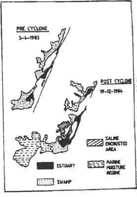
Figure 2(b) Estuary reactivation (Kalveli area)
4.0 Creek Environment
The creeks are comparatively less along Tamil Nadu coast and the analysis of Landsat and Thematic Mapper data of April 1983 and December 1983 shows that the 'creeks are dynamically changing due to the seasonal variations (Fig.3). The study of Ennore and Kovalam creeks are also dynamically changing during the southwest monsoon and suffer excessive sedimentation during this period.
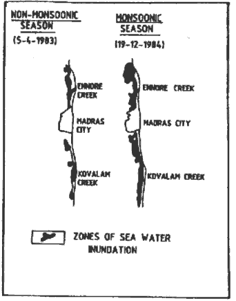
Figure 3 Creek dynamics in Tamilnadu
5.0 Conclusions
It has been found that multidate satellite data analysis could provide detailed information on the coastal zone/aquatic environment. The remote sensing provides an ideal tool for monitoring of backwaters and creeks and for siting of Jetties at appropriate places. The already exiting Jetties near Kalpakkam and Madras harbour causes excessive sedimentation near the Kovalam creeks and Ennore creeks so, the two proposed Jetties one near Mahabalipuram and another near Kasikovilpuppm will deflect the littoral current and will cause erosion near the mouth of creeks and promote regular inflow and outflow of sea water. In the Pulicat backwater, the mouth is silted much and construction of Jetties below the month or breaking the sand bunds by construction of break waters to destroy the deposited sand during the non monsoon period will ensure regular flow of sea water as backwaters.
The Indian marine fish catch in the past ten years has fluctuated between 1.444 to 1.779 million tonnes and as much as 90% of this catch is realised from the continental shelf area. The fish catch can be improved through efforts in the deeper oceanic areas and through aquaculture development in coastal areas. Remote sensing can play a vital role in both these areas. The SST charts being generated form NOAA-AVHRR data analysis provides information on potential zones for fishing. The coastal landuse maps generated form satellite data are found to assist in site selection for aquaculture development.
Reference
- Durariraj. S., (1988). Application of remote data for costal zone mapping - A case study of the part of east coast of Tamil Nadu, M.Tech. Thesis, Anna University, Madras, p.138.
- Parulekar, A.H., S.N. Harkantra and Z.A. Ansari, 1982. Indian J.Mar.Sci., 11,pp.107-114.
- Ramasamy, S.M., D. Kumaran Raju, T.Balasubramanian, S. Prabhu, (1991). Remote sensing and costal environment of Tamil Nadu, presented in ISRS Symp. on Remote Sensing and Environment at Anna University, Madras (In Press).
- Sambasiva Rao, M., (1987). Influence of coastal process along with the modern delta front of Godavari in Andhara Pradesh, Jour. Geol. society of India, Vo.29, pp. 339-404.