| GISdevelopment.net ---> AARS ---> ACRS 1995 ---> Poster Session 3 |
Use of Satellite Imagery for
Updating Terrain Information in Topographic Databases
K. D. Parakum
Shantha
Institute of Surveying & Mapping
Diyatalawa
Sri Lanka
Tel: 94-57-3016..Fax: 94-57-2004
Abstract
Institute of Surveying & Mapping
Diyatalawa
Sri Lanka
Tel: 94-57-3016..Fax: 94-57-2004
Current terrain-information capturing procedures are mostly based on conventional photogrammetric methods. These procedures are slow and data acquisition is expensive. Developing countries cannot afford the time and cost required to capture terrain-information for updating topographic databases. However, with the increasing development of the remote sensing technology, the satellite data, has wide application potential in terrain-information production.
The main objective of this experiment was to investigation the use of SPOT imagery for updating terrain information in topographic databases. The study covers: Identifying the inherent characteristics of optical satellite images, Investigating a method for extraction of linear features (eg.,roads) in SPOT multispectral images using model based .image analysis technique. The results shows that the feasibility of updating road network at 1 : 50000 scale.
Introduction
The demand for timely and accurate geo-information has been increased for the management of the earth related disciplines. In response to this demand, geo -information are being producing in map form as well as in digital form. In most of the developing countries are now in a position to update the ' existing geo-information for the use of their. development activities. Hence, the updating of this information should be less cost effective and less time consuming. The use of optical satellite imagery has this facility since its multi temporal and high resolution characteristics. With the use of ' SPOT multi spectral data, this study emphasis to update road network in topographic database. In this context, the study enable an opportunity to develop image understanding techniques to support the automated feature extraction of optical imagery that goes beyond the traditional extraction
Automated Feature Extraction
Automated feature extraction is performed by segmentation techniques. Segmentation is a process of generating image segments in which image elements having the same properties are merge together. According to the basic principle, the segmentation method can be divided into different categories, such as edge based segmentation, region based segmentation and segmentation in measurement space (spectral clustering).
In the edge based segmentation the goal is to find discontinuities in the image while region based segmentation is interested in the inner pixel of homogenous area, not the boundaries. Spectral clustering is based on the spectral values of the image pixel and it implies a grouping of pixel in a multispectral space. These three segmentation method can be considered as conventional procedures for image segmentation.
The new approach of image segmentation is segmentation with model based image analysis. Model based image analysis is based on the analysis of the image model that considers the recognition of objects by assuming a model for how real world features are represented in the image.
The Model for Image Segmentation
The major point of interest is to detect linear features from SPOT MSS imagery. Linear features detection can be identified as a process for detection of the region heterogeneity in the image. Image heterogeneity can be measured considering local image coefficient variation. Therefore, the distribution of the reflectance values of homogeneous area has to be modeled and deviation from this model can be considered as heterogeneities.
The point source on the ground is seen on an image as a diffused circular region, due to the properties of the optical involved in imaging. A cross-section of the recorded or imaged intensity distribution of a single point source is shown in figure 1.0 and it can be seen to having a Gaussian-type distribution (Paul, 1987). The actual shape will depend upon the properties of the optical components of the system and the relative brightness of the point source. The distribution function shown in figure 1.0 is called the Point Spread Function (PSF) (Moik, 1980).
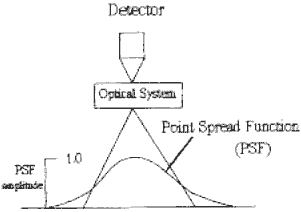
Figure 1.0: Point Spread Function
With this criteria the model assumed that the variation of reflectance values of homogeneous areas can be described by a Gaussian function.
When a linear feature or point feature is inside the homogeneous area, the mean of the reflectance valuees of homogeneous area can be described by a gaussia function . when a liner feature or point feature isinside the homogeneous area the mean of the reflection value within a window will be changed. Associated variance will be changed considerably with respect to the change of the mean value.
According to that, heterogeneity can be detected by considering the variation of the coefficient variation within a small window. It should be noted that for small window the statistics is not as valid as it is for large window. But large window do disappear small features.
Procedures for Testing the Model
Two procedures are adopted to test the model.
Procedure (i) :
In this procedure, the variation of the reflectance value in a neighborhood around the center pixel of sub image is used to determine the homogeneity of an area. For that, the center pixel value is replaced by the variance of sub image. The existence of a heterogeneity is indicated by the higher value of the center pixel in the output image associated with the higher variance of the sub image.
The selected window size for sub image be small in order to find the significant variation of the variance due to thin lines or points.
The algorithm is :
Begin
For every (i,j) position on the original image Do
Take the 3x3 surrounding sub image;
Compute the variance of sub image;
var-image (i,j)=variance of sub image;
End.
By slicing the variance-image at a certain threshold, only the heterogeneous areas (points, lines, edges) are detected. The algorithm for the thresholding is :
Begin
For every (i,j) position on the var-image Do
If var-image (i,j) >= threshold;
Then binary (i,j) = I; (points, lines, edges)
Else binary (i,j) = 0;
End.
Procedure (ii) :
It considers the rank order of a sub image (3x3). The presence of homogenous areas assume the rank 2 and rank 8 falling within the probability range of 5% and 95% in the Guassian distribution. Therefore, the range between rank 2 and rank 5 is equal to the that of rank 5 and rank 8. In the presence of heterogeneity, two ranges are not equal.
The algorithm is :
Begin
For every (i,j) position on the original image Do
Take the 3x3 surrounding sub image;
Sort its 9 values into the array Rank;
r2_image = Rank(2);
r5_image = Rank(5);
r8_image = Rank(8);
r2_5_image = Rank(5) -Rank(2);
r5_8_image = Rank(8) -Rank(5);
Hetro_image = r2_5_image- r5_8_image;
End.
Conclusion
This study compared extracted features with the information content of the map at 1 : 50000 scale. This comparison shows that main roads and secondary roads can be detected successfully with SPOT multispectral images. However, resolution is important since it was not possible to identify tracks and unpaved roads with low resolution.
The experimental results shows positive indications for updating main roads and secondary roads in road network at 1 : 50000 scale.
References
- Moik. J (1980). "Digital Processing of Remotely-Sensed Images", NASA special publication 431, Washinton DC.
- Paul M. Mather (1987). "Computer Processing of Remotely-Sensed Images", John Wiley & sons, ISBN 047190648 4,Chapter 2.
- Parakum Shantha K. D. (1992). "Use of Radar Imagery for Updating Terrain Information in Topographic Databases", Dissertation, ITC, The Netherlands.