| GISdevelopment.net ---> AARS ---> ACRS 1995 ---> Poster Session 2 |
Identification of Landuse in
Songkhla Lake from the Globesar Data
Dr.Suvit
Vibulsresth1, Dr.Darasri Dowreang1, Miss Supapis
Polngam1, Mr. Weerapant Musigasan1, Mr.Marc
D'Lorio1
1National Research Council of Thailand, 196 Phaholyothin Road
Chatuchak, Bangkok, 10900, Thailand
Tel. 662-579-0345, Fax. 662-561-3035
2Prince of Songkhla University, Box 2, Kohong, Hat Yai,
Songkhla, 90112, Thailand, Tel. 662- 74-212895 :
3Canada Centre for Remote Sensing, 588 Booth Street,
Ottawa, Ontario, KIA OY7, Canada,
Tel. 613-947-, 1350, Fax. 613-947-1385
E-mail : diorio@ccrs.emr.ca
Abstract 1National Research Council of Thailand, 196 Phaholyothin Road
Chatuchak, Bangkok, 10900, Thailand
Tel. 662-579-0345, Fax. 662-561-3035
2Prince of Songkhla University, Box 2, Kohong, Hat Yai,
Songkhla, 90112, Thailand, Tel. 662- 74-212895 :
3Canada Centre for Remote Sensing, 588 Booth Street,
Ottawa, Ontario, KIA OY7, Canada,
Tel. 613-947-, 1350, Fax. 613-947-1385
E-mail : diorio@ccrs.emr.ca
As part of the GlobeSAR program, the simulated Radarsat data with fine resolution and standard modeproducts were generated from the SAR data which were acquired by the Canada Centre for Remote Sensing convair 580 aircraft with C-band and HH-VV polarizations. The data were taken in November 1993 covering Songkla lake and Thalae Luang area. During the data acquisition an extensive ground truth - information was collected to support data analysis and interpretation. The results showed that serveral land use classes could be identified and differentiated. These classes include shrimp farm and other aquaculture activities, rubber plantation, paddy field and urban area. Espectially the shrimp farm was clearly displayed on the single image. So there seems to be a potential for this data to be ~ used as a tool for monitoring the expansion of shrimp farms. However, it was found difficult to separate mixed ~ orchard from swamp forest area because of volume scattering from various sizes of canopy which made them : appear very bright with coarse texture on the image for both cases. Future study will include the use of color composite of the radar data and Visible -Infrared data as well as another SAR data as could be more ,61 favorable for land use study than a single image.
Introduction
The Canada Center for Remote Sensing (CCRS) and the National Research Council of Thailand.(NRCT) have coorperated under The GLOBESAR project since 1993. The purpose of this cooperation is to promote the application of radarsat data by inviting researchers from involved organizations who wish to conduct research using the radarsat data.
Under this project; 8 test sites were defined by researchers, each test site addresses the potentials of .", using radarsat image. TH4 is one of those test sites covering Songkhla lake and Thalae Luang area, Southern r Thailand. On November 5, 1993, airborne radarsat image was acquired by The Canadian SAR Sensor System, r1 on boarded convair .580 aircraft,. which operated in C-band with HH and VV polarization's. During such time, the area was. occupIed by growing stage of paddy and on terrace, there were :artless of feature that ranged From bare soil prepared for rubber, young rubber, and productive rubber plantations.
2. Project Objectives
To study how radarsat data can be used as inputs for development planning and monitoring of the project area
3. Study Area
The study area covers most of Songkhla lake -Thalae Luang area. It lies approximately between latitude 6° 57' -8° 12'N and longitude 100° 12' -100 35'E. The area is 22 kilometers wide and 135 kilometers long. The physiography of the area can be described as follow: The eastern part is characterized as." a coastal plain which consists of long stretches of sandy beach, broken only by major rivers, and followd by a series of parallel beach ridges. Between the beach barriers and the oldest series of beach ridges are the Lagoons. They are extremely shallow (2 meters in most places) and clearly undergoing rapid sedimentation, the western part is swamp. Sediments, are from the numerous short rivers that no longer have direct access to "' the sea .The area is planted with coconuts, sugar palm, fruit trees and rubber plantation is contrast with paddy cultivation of the back swamp., The climate is defined as northeast monsoon and southwest monsoon (see figure 1 : The study area)
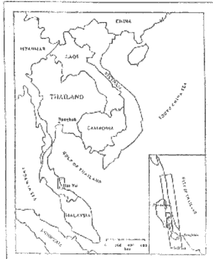
Figure 1 : Location of the studyarea, TH4
4. Data Acquisition
4.1 Satellite data
Data Holdings
- The Airborne radarsat image, C-band, with was deployed by the CCRS convair 580 aircraft at an altitude of 6 kilometers. The observation date was November 5, 1993, HH and VV polarizations, right look direction.
- Landsat-5 TM of path 128 row 55, acquired on September 10, 1992 and February 20, 1994.
- ERS-l SAR C-band, VV polarization, acquired on October 11, 1993
- Spot 2 HRV of K 265, J 336, and K 265, J 335 (2 scenes) acquired on January 01, 1994 and September 03, 1993 respectively
- JERS-l OPS and SAR data acquired in November 1993.
Ground information collection was carried out during radar pass on November 5, 1993. The data collected from field observation include various ground objects and also personal interview with local farmers.
4.3 Topographic maps
Topographic maps at a scale I :250,000 and I :50,000 which were reproduced by the Royal Thai Survey Department
4.4 Thematic maps
Soil suitability map and existing land use map will be used for supporting image analysis
4.5 Other related research reports
5. Methodology
Image analysis will be done on a Meridian package software available at the Thailand Remote Sensing Center .
5.1 ImagePre-Processing .
Geometric correction was done on the original data, the simulated radarsat image, by registering to a Universal Transverse Mercator (UTM) projection and resampling using a Nearest Neighbour technique to 6, 12. 5 and 18 meter square pixel sizes and then use this image as a reference image to which all data were registered.
Corresponding to the available satellite data, data analysis was conducted with two approaches. The first, the potential of airborne radarsat image was identified in term of object characteristics. Second, analysis of land use and land cover will be based on multisensor data of Visible-Infrared data and SAR data (see figure 2 : The processing flow chart)
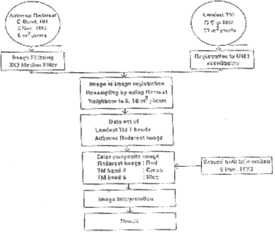
Figure 2 : Processing chart of muitlsenser study
In order to remove the speckle noise which mask the fine data. A standard filtering, 5 by 5 median filter was applied by using the Meridian system.
Results
The geocoded radar image is used here to illustrate the capability for detecting an object characteristics due to imaging system characteristic, and the differences in viewing geometry that appeared on the image in black and white tone. Black or dark tone signifies little or no return signal to the sensor while bright or white features indicate the higher return signal. The TH 4 image was categorized with regard to identification of tone, texture, pattern and association. Based on the project objective, 8 categories were delineated (see Figure 3). Table I illustrates a correlation between the object charateristics and their tone. But, the result indicate some confusion among a standing tree features such as swampy forest, mangrove forest, and mixed orchard. Because of a coarse surface roughness from vegetation canopies which are provide high return signals. Color !' composite of the radars at and Visible -Infrared data as well as another SAR data were applied with , expectation of landuse and land cover than use a single image. Figure 4 shows an example of the combination of SAR data and Landsat TM data. A satisfactory results were obtained with regard to the identification of color and another component. Swampy forest was clearly distinguished from mangrove forest (Figure 4;4a,4b).
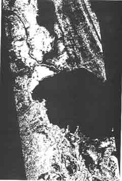
Figure 3 The airborne SAR C- Band, HH polarization data
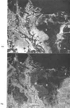
Figure 4 4a : Color composite of landsat TM data with band 4, 5 and 3 displayed in red, green and blue
4b : Color composite of SAR data, TM band 4 and TM band5 which were given in red, green and blue, sub area of Songkhla Jake.
Feature key:
1 = Mangrove Forest
2 = Swampy Forest
Conclusion
This progress report describes how the airborne radarsat image could be used for identifying the object characteristics in Songkhla lake- Thalae Luang area. The first result from the identification of airborne radarsat image has provided an excellent demonstration of sensitivity of radar backscatter to the surface. The results are surface scattering from high vegetation canopies or coarse surface roughness is uniformly high backscatter such as sugar plam trees in rice field, bamboo poles for aquaculture and rubber trees while a surface scattering from low vegetation canopies or a smooth surface has no return signal or small scatters energy back to the sensor like rice field in early stage, aquatic plants on swamp area. Besides, surface roughness effect, moisture condition also show high backscatter in floating grass. However, a precision data registration and SAR data filtering should be carefully processed in order to retain the identification accuracy of data.
| No | Description | Tone | Texture/Pattern | Remark |
| 1 | Paddy with SugarR Palm | Bright | Regular pattern with coarse texture | Sugar palm trees are dominant feature, to act as corner reflector |
| 2 | Raindfed Paddy | Dark | Rectangular pattern , fine texture | In november , paddy is in early stage Mostly cover with water |
| 3 | Off-Seson Paddy | Bright | Regular pattern , fine texture | In November, off-season paddy is in fully growth stage |
| 4 | Field Prepration For Rubber Plantation | Dark | Regular pattern quite coarse texture | no return signal |
| 5 | Rubber Plantation | White | Rectangular pattern quite coarse texture | |
| 6 | Floating Grass | White | Rectangular pattern quite coarse | |
| 7 | Shimp farm | dark and Surrounding white line | Rectangular patern | caused by reflectance from pond ridge, appearing white around the pond |
| 8 | Aquaculture | White Spots | Spot | high return singnal |
8. Reference
- David S. Simonett, Manual of Remote Sensing, Second edition, Volume I, P 114 -1158.
- Le Toan, T., H. Laur, E. Mougin, and A. Lopes. 1989, Multitemporal and Dual-Polorization Observations of Agricultural Vegetation Covers by X-band SAR Image, "IEEE Trans- actions on Geoscience and Remote Sensing, Volume. 27 (6), PP. 709- 718.
- Musigasarn, W, S. Polngam, and C.Jee-Rajunya. 1994, GlobeSAR Input for Development Planning of songkhla Lake Basin (TH4), Proceedings, GlobeSAR Southeast Asian Regional Workshop, " "ki!tr.~ Bangkok, Thailand.
- Rob Schumann, SAR data for Cartographic Application, paper submit to training cource on ERS-l & SPOT: A Complementary tool for Natural Resources Management, August 19-26, Bangkok