| GISdevelopment.net ---> AARS ---> ACRS 1995 ---> Poster Session 2 |
Field Prediction and
Potential Monitoring of Cassava Production in Nakhon Ratchasima
A. Eiumnoh1, R.
P. Shrestha1, S. Baimoung2, P.
Kesawapitak3 and A.
Noomhorm1
1SERD, Asian Institute of Technology, G.P.O. Box 2754, Bangkok 10501
2 Department of Meteorology, Bangkok 10260
3Department of Agriculture, Bangkok 10900
Fax:9821:650377
Abstract
1SERD, Asian Institute of Technology, G.P.O. Box 2754, Bangkok 10501
2 Department of Meteorology, Bangkok 10260
3Department of Agriculture, Bangkok 10900
Fax:9821:650377
The potential monitoring of cassava production in Nakhon Ratchasima province, Thailand was conducted using Remote Sensing (RS) and Geographic Information Systems (GIS) in integration. The soil units, topography and general landforms were digitized and grouped according to their surface texture, slope and elevation and types of land form respectively. The cassava productivity factors including soil moisture, drainage condition, effective soil depth, texture, organic matter content, base saturation, cation exchange capacity, .mineral reserve and fertility level were evaluated for land suitability classification. The soil, topography, landform and cassava productivity were analyzed for potential land productivity grouping. Landsat TM of 1995 was used to classify cassava area and to compare misclassified land uses with land use map of 1993. Land suitability evaluation for cassava was carried out to compare with existing cassava area. The NOAA-A VHRR data in 1993 and 1995 were used for monitoring purposes. It was found out that, however, remote sensing data are still having many limitations and .constraints in monitoring of cassava production, integration of GIS and remote sensing can be exploited to have its fullest , usefulness.
1.0 Introduction
There have been about 24 folds increase in the area of cassava cultivation in Thailand in the last three decades (Figure 1 ) to be Thailand as the major cassava producer in the region. This tremendous growth can be attributed to the unique capability r-. of cassava for producing high biological and economic yield under marginal and low-input conditions and its flexible : agronomic requirements. North-eastern region which is comparatively depressed than other regions of the country contributes .about 60 percent of the total cassava production.
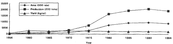
Figure I. Cassava cultivation area, production and yield. (Source: O.A.E. Agricultural Statistics, 1954/55 to 1993/94).
The popularity of cassava cultivation is attained due to both marginal land quality of North-east region and also high price fetching of cassava products in the. past. Majority of cassava produced in the country .is exported. to EEC corntries and less than 10 percent of It IS used for domestIc consumption. In the read Just ment of EEC's polIcy to restrict cassava Imports, as per 1980's agreement between Thailand and EEC, Thailand would limit the export to 5 million tons of pellets equivalent to 12 million tons of fresh roots (Titapiwatanakun, 1984). On the contrary, with the development of new high yielding varieties and expansion of cultivated area, the production trend remained increasing and is estimated to reach 17.57 million tons in the year 1996 ( TTDI, 1995).
As the production is export oriented such limitations of the trade treaty would mean that excess of production has to be consumed within the country for which it has to be seriously reconsidered either opening domestic market consumption or limit the cassava production. In the lack of this, the country and its farmers will have to face face the challenge of a great economics loss .
Monitoring of cassava production in Thailand have been traditionally relied on field information gathering . application of advance remote sensing and GIS has not gained popularity yet in this field. Moreover, cassava can be harvested for a'longer period of time, its monitoring for production predictions becomes difficult. To cope these situations a study of three years ~ " duration has been started by Asian Institute of Technology to predict the cassava cultivation and production and suggest the suitable land for cassava cultivation. This paper, as part of the study, discusses the piece of work predicting the cassavaproduction and suggest the land suitability for cassava in Nakhon Ratchasima.
2.0 The Study Area
Nakhon Ratchasima province is situated on Korat plateau of the North-east region of Thailand covering 12,811,162 rai (O.A.E., 1992). The climate is tropical Savannah with minimum and maximum temperature ranging from 14.1 to 39.5° C. The area receives an annual rainfall of 1,062.4 mm in an average annual rainy days of 104. Paddy is the principal crop on lowland and cassava on the upland followed by sugarcane and corn. This province is the largest among the cassava producer provinces in the country
3.0 Methodology
The research methodology is presented in Figure 2 which employs the tools, such as, Remote Sensing, Geographic Information Systems (GIS) and field surveys. The basic source materials used were:
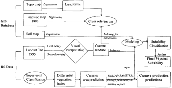
Figure 2. Conceptual framework of research methodology.
- Topo map (1:250,000), Royal Thai Survey Department, 1984 I
- Land use map (1:250,000) O.A.E., 1993
- Landsat TM hardcopy (1:250,000), February 1995.
- Soil Map (I :500,000), Soil Survey Division, 1982.
- Climate data -Published and unpublished reports, documents, etc.
4.0 Results and Discussion
4.1 land use
The land uses of Nakhon Ratchasima province interpreted from Landsat TM (1995) are presented in Table 1. ID the province, Rice is the dominant land use types (42.31 percent of the total province area), which has been increased from what : has been interpreted from the Topo map for paddy land (34.61 percent). The forest area of 17.72 % has been decreased to 15.48% in 1995. Cassava is the second to rice in areal extent followed by other upland crops.
| Interpreted from Landsat TM, 1995 | Interpreted from Topo Map | ||
| Land Use | % of total area | Land forms | % of total area |
| Rice | 42.31 | Water body | 0.42 |
| Cassava | 16.20 | Low land (paddy) | 34.61 |
| Upland | 14.61 | Upland | 47.25 |
| Corn | 0.72 | Forest | 17.72 |
| Sugarcane | 5.89 | ||
| Tree crops | 0.02 | ||
| Rubber | 0.01 | ||
| Other | 0.15 | ||
| Orchard | 1.99 | ||
| Shrub land | 0.47 | ||
| Forest | 15.48 | ||
| Grassland | 0.30 | ||
| Urban | 1.51 | ||
| Water | 0.10 | ||
| Total area of the province -12,811,162 rai ( equivalent 2,049, 786 ha) | |||
Existing cultivation of cassava are found on almost all types of soils. 37.3% of the total area under cassava are found to be cultivated on clayey upland soils followed by 33.9% on loamy upland, 10.3% on skeletal upland, 7.9% on sandy upland, 7.1% on associated soils, 2.1% on slope complex and 1.4% on cracking upland soils (Figure 3). It implies that cassava do not need specific physical requirement so far the land qualities is concerned. It is rather that the cultivation is largely governed by "" soil drainage condition and social and economic factors as well.
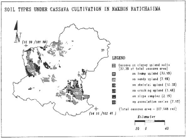
Figure 3 Soils types under cassava cultivation in Nakhon Ratchasima
4.2 Land Suitability Classification for Cassava
In Nakhon Ratchasima province, as much as, 14.8 percent of land of the total provincial area was found to be most ..suitable for cassava cultivation (Figure 4). The area classified under moderately and marginally suitable were 16.73 and 4.09 r percent, respectively. Nearly 2/3rd of the province (64.42 %) are found not suitable for cassava cultivation. Since the proportion o most suitable area is still less than.the area being cultivated (16.2%), it articulates that not all the cassava area in the province yield good economic return. Most suitable area are presently under cassava and limited, at majority, to loamy upland and little to " clayey upland soil types. Moderately suitable area falls under the sugarcane and other land under upland crops at present.
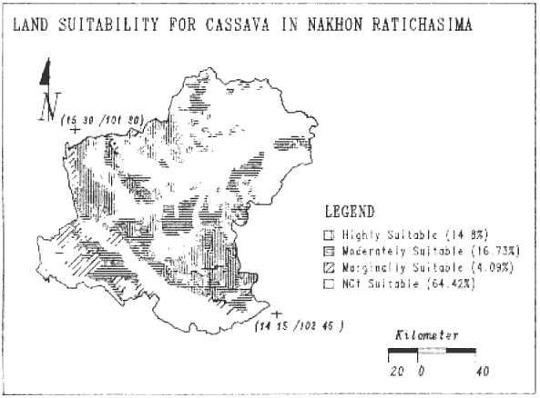
Figure 4 Land suitability for cassava in Nakhon Ratchasima
4.3 Monitoring Cassava Cultivation and Field Prediction
4.3.1 Database Inconsistency
There are varied statistics reported for the area under cultivation of cassava and so are the productions (Table 2). Obviously, in the lack of reliable information, it is difficult to formulate sound policy planning whether it is the case of cassava production and trade or other aspects of planning. This differences might be basically due to the differences in methods used for monitoring purpose. In most cases, the monitoring does not employ the advanced tools like remote sensing for monitoring purpose but based on field surveys especially interview with the key informants or the farmers. In other case, land use maps are, however, prepared from interpretation of satellite data, selection of data and expertise largely dictates the level of accuracy and current information. Due to inadequate linkages in sharing the database and calibrating the database standards, database reported from various sources vary to a greater extent. In simple case to cross reference, the area derived from the digitized land use map is much higher than from other sources as shown in the table below.
| Crop | Area (rai) | % of province area | Yield (ton/rai) | Production ('000 tons) | Sources |
| Cassava | 1,600,000 | 12.5 | 2.35 | 3,760 | Thai Tapioca Dev. Institute |
| 1,905,306 | 14.9 | 2.20 | 4,191 | O.A.E. Statistical reports | |
| 3,228,939 | 25.2 | - | - | Derived from Land use map, O.A.E., 1993 | |
| 2,075,408 | 16.2 | 2.20 | 4,565 | Interpreted from Satellite data (LS_TM '95) |
4.3.2 Remote Sensing Data Types
As the project area includes all the cassava growing provinces of Thailand, the study initially planned to use NOAA- A VHRR data (coarse resolution of 1.1 km) for monitoring purpose because of its temporal benefits and larger area coverage in relatively lower cost compared to that of Landsat- TM (high resolution of 30 m). To work with minimum data sets, besides costs matter it requires incomparably considerable data volumes and time while working with Landsat- TM for digital analysis. On the other hand, it was observed during the repeated field surveys that the size of the cassava fields are not only smaller than the required mapping units for the employed data (NOAA-A VHRR) in some part of the area but also it makes difficult to establish signatures for the training area in the satellite data because of their varied signatures representing different crop stages in the field. It is primarily due to the fact that cassava is such a crop that the harvesting season of this crop is not limited to particular period but rather prolonged depending upon the market situation. This means at a particular point of time, there could be various types of spectral signatures for cassava depending upon the crop' s growth stages. Because of these reasons of crops versatility of the growth and to accommodate smaller field sizes, the area was cross referenced using currently acquired Landsat- TM.
5.0 Summary
The study is along tenn project which aims to predict the cassava production in Thailand at the national scale for the coming few consecutive years. However, with these arguments in this paper, it can be resolved that there is the need of establishing reliable database which can be achieved through the proper selection of the methods and data sets to be used. It also calls for the inter-agency linkages and coordination for the calibration of database. To cope the situation of ever increasing cultivation of cassava vis-a-vis export limitation it is important to monitor the cassava production in tenns of areal extent and yield parameters. Land evaluation will not only suggest to get the better economic yield but also help abate the pace of land quality deterioration.
Remote Sensing data are the best means to monitor the cassava cultivation, however, there are limitations associated with the data types. Coarse resolution satellite data (NOAA-A VHRR) can successfully be utilized for monitoring at regional level, cross-referencing with high resolution data like Landsat_TM will give the reliable results. Similarly, GIS integration with remote sensing will help to a great deal for planning purpose.
References
- Cock, J. H. 1985. Cassava: New Potentia/ for a Neg/ected Crop, Westview ,
- F .A.O. 1983. Guide/ines: Land Eva/uationfor Rainfed Agricu/ture. F AO Soil Bulletin No.52, Rome.
- L.D.D. 1992. Quantitative Land Eva/uation Manua/ for Economic Crops, No.2., Land Development Deparbnent, Bangkok.
- O.A.E. 1992. Agricultural Resources Map Interpreted from Satellite Data, Volume I, Office of Agricultural Economics, Bangkok (in Thai).
- O.A.E. 1955 to 1994. Agricultural Statistics of Thailand, Crop year 1954/55 to 1993/94, Office of Agricultural Economics, Bangkok.
- Titapiwatanakun, B. 1984. "Cassava in the Agricultural Economy of Thailand", In: Cassava in Asia, its Potential and Research Development Needs, CIA T/ESCAP-CGPRT Center.
- T. T .D.I. 1995. Annua/ Meeting Reports, Thai Tapioca Development Institute, Bangkok.