| GISdevelopment.net ---> AARS ---> ACRS 1995 ---> Poster Session 2 |
Simulating firest degradation
: Apling the Area Product1on Model 1n the Ka11 Konto area 1n East Java,
Indonesia1
Alfred de Gier and Yousif
Ali Hussin
International Institute for Aerospace Survey and Earth Sciences
(ITC)Enschede The Netherlands
Fax: +31 53 874399
E-mail: degier@itc.nl
Abstract International Institute for Aerospace Survey and Earth Sciences
(ITC)Enschede The Netherlands
Fax: +31 53 874399
E-mail: degier@itc.nl
Forests cover large areas of the global land surface. For many developed and developing countries, they represent an important source for their economies. Due to the growing need for more agricultural land, more and more forests are under the risk of degradation and disappearance. To safeguard forests from extinction, alternative food production strategies need to be developed, while at the same time proper management of the forest resources is required. All this requires information on land use and its changes, and on the people who engage in these processes. This information is important to those who are responsible for forest and land use policy development, and to those engaged in land use planning and management.
The Area Production Model (APM) permits the simulation of future land use changes in response to population growth, changes in gross domestic product, and in agricultural productivity. The model was developed for the Food and Agriculture Organization (FAO) of the United Nations by Nilsson in 1984. The model is used for long-term scenario development and analysis. In its original form, the APM is numerical (and graphical) in data requirements and output. This paper shows that the Area Production Model can be used for the simulation of forest degradation in an area in East Java, Indonesia, using a combination of multitemporal aerial photograph, satellite and field data.
Introduction
Tropical deforestation is one of the major concerns today. Current deforestation rates are estimated to be about 15.4 million ha per year (FAO, 1994) .However, forest degradation, as a result of unsustainable human activities, affects an even larger area of forest annually.
The importance of forests is well recognized by governments worldwide, as reflected in the "Forest principles" that were adopted by the UNCED conference in 1992. Foresters and all other land users and land use planners should therefore find ways to control, stop, and even reverse this process. Politicians are supposed to decide on and implement the required institutional measures. Given the speed of the process, two issues are clear: actions are needed without undue delay, and a sustainable effect of such actions can be expected only if the causes of the problem are tackled. The problem thus needs to be examined from a cause-effect point of view.
The major cause of forest destruction is the need for more agricultural land, which itself is largely a consequence of rapid population growth and rising economic expectations. This means that the major function of forest land is that of donor for agricultural land. In addition, the need for timber, fuelwood and cash also influence forest destruction. These causes should therefore be approached from a perspective of land and its .products, and the increasing demands for it. Since, in principle, demand for more agricultural land (at least in part) could be met from non forest land, not only forest land but also the agricultural lands in the area should be included. However, the need for more agricultural products not only can be met by bringing more land under cultivation, but also by .increasing the productivity of existing agricultural land, i.e., by ' intensifying agricultural land use.
The development of the Area Production Model (APM) (FAO, 1986a) has been an important step in simulating land use changes, by varying the input .variables. The APM is intended for simulation of long-term land use changes and the prediction of primary and secondary yields from agricultural and forest lands. One of the major features of the APM is its capability to simulate the future need for agricultural land. The p model's demand and supply scenarios for agricultural products and land r are generated primarily by the growth rates of population and GDP, and by changes in land productivity. The model is comprehensive, but does not have excessive data requirements.
The model uses three different agricultural classes:
- Land for sussistence crop (used mainly for home consumption )
- land for market crops (produced mainly for the local markets)
- land for cash crops (destined primarily for markets outside the area) .
The model has been tested in East Java, Indonesia and in Rachabury Province, Thailand (FAO, 1986a and 1986b) and in two parts of Peru .(APODESA, 1989) .In the three cases, tropical forest areas were included. The conclusions were that the model was adequate and sufficiently adaptable for extension as well as modification. The original FORTRAN version was later converted to LOTUS 123 (Williams 1987) .
The APM requires numerical data input. Its output is in tabular and graphic form. Spatial data are neither required nor produced. The APM is r therefore insensitive to the location where the need for more land exists, and to the location of the donor land use class from which land : is to be transferred. This is considered a major limitation, because it -is not possible to predict where the land for the specific classes will be needed, and where the land of the relevant donor class is located. Furthermore, a spatial model would allow to grade accessibility to , potential donor land, by using friction coefficients. It could also simulate the locational effects of decisions that influence the need for .land transfer.
De Gier and Hussin (1993) described how the spatial component was developed and succesfully linked to the model for the Kali Konto area in , east Java, Indonesia. All spatial data used were in digital form. The results of this spatial implementation show the suitability of GIS for combining the spatial component and the numerical output from the APM.
Further enhancement of the spatial version was desired, to accomodate multi-temporal spatial data of transfer processes as they occur in reality. The outcome of this would then be used to calibrate the model, .and would allow the determination of key operators. The test site was the, Kall Konto area (Flgure 1), a sub-watershed of the Kali Brantas watershed : in East Java, Indonesia, for which multi-temporal data were available. The Kali Konto sub-watershed covers some 23,500 ha, of which about 15,685 ,. ha are classified as forest land, owned by the state. The elevation : varies between 620 m and 2650 m a.s.l. The existing forest consists of natural stands and plantations which are mostly for protection and preservation. 1991, the population of ,more than 100, 000 people lived in villages outside the forest land .About 75 percent of them were small farmers and. laborers. They crave land since they are unskilled for work otherthan in agriculture. About half of. the labour force is unemployed or under-employed.
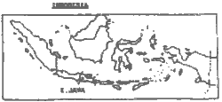
Figure 1 The location of the Kali Konto area
Wood is an important commodity in the rural areas. It is used as fuel in households and small industries, and as poles for housing. An unknown number of (mostly landless) people gain their income by illegal cutting and selling fuelwood from the nearby forests. This process has led to severe degradation of the natural forests in many parts. According to Project Kali Konto (PKK, 1984) , forest is defined as land that has a tree crown cover of more than 20 percent; scrub has a tree. ' crown cover of 20 percent or less. The latter can include failed or abandoned plantations. In 1979, the proportion of scrub land was 18 percent.,;
Unlike forest lands outside Java, conversion of state forest lands to non-forestry purposes is not allowed by law. In the field, the state ' forest land boundary is separated from privately owned village land by clearly visible concrete boundary-posts. Land transfer from forest to agricultural land (as predicted by the APM) will in reality not occur forest land remains forest land even if the forest cover changes.
There is very limited non-forest land available for transfer to agriculture land. The easiest way for the landless and the poor people in this area to satisfy their basic needs is to go to the forest, cut the trees, and sell them for timber or fuelwood. The income is used to buy food and other goods. This compensates their need for agricultural land, but at the same time causes degradation of the forests, and ultimately leads to scrub land. It follows that population growth in the Kali Konto area does not lead to new agricultural land, but to scrub land.
The main aim of this paper was to determine whether there is a relationship between the amount of new agricultural land as calculated by the APM over a given period of time and the actual increase in area of scrub land in the same period. If this relationship exists, the APM can help forest "' policy makers to anticipate future forest degradation, and to suggest timely action
Materials and Methods
To enhance the spatial component of the APM, the numerical results of theoAPM were used to define the spatial expansion of agricultural land over forest land on a year-by-year ,basis. Next these. expansion, areas were grouped 1n 10-year classes. finally, the expans1on was l1m1ted to a per1od of 50 years, the normal t1me hor1zon for APM.
The following data were available for the Kali Konto area: panchromatic ,! aerial photographs, scale 1:20 000 of 1979; landuse map of village land and forest lands, based on the 1979 aerial photo interpretation; a Landsat MSS image of 1982; panchromatic aerial photographs, scale 1:20 000 of 1984; and field data of 1993. A TM image of 1989 was rejected because of cloud cover.
The boundaries of the cover types on the two land use maps mentioned above were digitized, resulting in digital land cover maps of 197 9. Next, the types were grouped into the classes as required by the APM. The 1982 Landsat image was classified on the basis of bands 4,5 and 7, and a supervised classification algorithm, using a maximum likelihood classifier. The result of the classification was filtered twice by applying a 3x3 median filter. The aerial photographs of August 1984 were interpreted and classified using the same classes of forest cover as in the 1979 data. The class boundaries were subsequently digitized. The forest cover map of 1993 was made using sketch mapping techniques. The .same forest cover classes were identified and delineated during afield .check with the help of an orthophoto mosaic and a forest plantation map .of 1979. The class boundaries were then digitized.
From the local administrative and agricultural offices, data were .collected on population and population growth, GDP and GDP growth, and .agricultural production and production growth for the various crops : concerned. Overlay techniques, using the ILWIS GIS, then permitted a .multi-temporal analysis of land cover changes. The year 1979 was the base ~ year from which all changes were monitored...
Results and Discussion
Table 1 shows the presence of the following land categories in 1979 (groups of three classes each)
| APM category | Land use/land cover | ha |
| Agricultural | land | 5756 |
| Forest land | farm | 1577 |
| Forest land | industrial | 2781 |
| Forest land | environmental | 12898 |
| Other | land | 1266 |
After comparing the cover of the privately owned agricultural land and farm forest land (so-called village land) of 1979 and 1993, it was noted that hardly any change had occurred. It was also noted that it is very difficult to separate land use/land cover classes on village land, using the 1982 Landsat data. It was therefore assumed that within the village land no transfers took place (i.e., for the purpose of using the APM, all new agricultural land is supposed to come from forest land) .Table 2 shows the changes in areal extent of the various land cover classes, and also the amount of agricultural land requirements as calculated by the APM (Hargyono, 1993) .
| Class | Area (in ha) in year | |||
| 1979 | 1982 | 1984 | 1993 | |
| Lake | 319 | -*) | 319 | 319 |
| village land | 6669 | -*) | 6669 | 6669 |
| Built-up | 906 | -*) | -906 | 906 |
| Plantations | 2939 | 1808 | 2883 | 2717 |
| Natural forest | 7171 | 7708 | 6382 | 6138 |
| Scrub | 5625 | 6162 | 6413 | 6823 |
| Agricultural land required, according to APM *not mapped | 5757 | 6062 | 6275 | 6991 |
Figure 2 shows the relativnship between the required area, as calculated by the APM, and the actually observed area of scrub. The corresponding trend is approximated by the curve shown in Figure 3.This relationship indicates that the scrub area increases, as the need for agricultural land increases, but at a decreasing rate. More research is needed to explain the relationship, but it may be explained partly by the fact that an increasing part of the population finds employment in the towns just outside the study area. They would not require land for subsistence food.
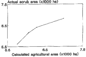
Figure 2 Relation actual scrub area and APM-calculated agricultural area
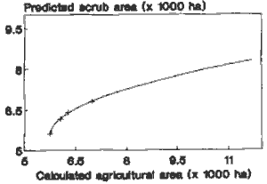
Figure 3 Predicted scrub area according to APM-calculated agricultural area
The results as shown in Table 2 are numerical. The scrub areas, as they developed between 1979 and 1984, and between 1984 and 1993, are shown in Figures 4 and 5. These figures show two important aspects: (1) scrub areas develop mainly on the fringes of the forest, and (2) scrub areas do not develop uniformly along all these fringes. Comparing the two figures, a number of differences are clear: for the eastern village area the scrub edge at the northern boundary expanded almost uniformly between 1979 and 1984. Between 1984 and 1993, however, scrub expansion was confined mainly to the eastern part of the boundary. On the southern forest border of the same village area ,scrub increase was more prominent in the eastern part of the border between 1979 and 1984, and in the western part between 1984 and 1993.It is also interesting that scrub increase was minimal along the borders of the western village area. In some places, scrub advanced into plantation forest areas between 1984 and 1993.
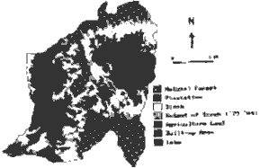
Figure 4 Scrub land increase 1979-1984
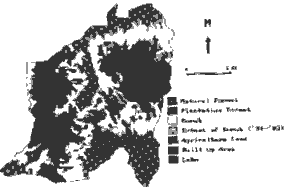
Figure 5 Scrub land increase 1984-1993
Figure 6 shows the results of the selective spatial expansion of the agricultural land into the forest land, as calculated by the APM.

Figure 6 Agricultural expansion, according to APM 1980-2030
The calculated agricultural expansion is evenly distributed, according to the priorities set, and located just adjacent to the existing ,agricultural areas. In respect of expanse of agricultural area, the numerical and the spatial APM agree Comparing Figure. 6 with Figures 4 and 5, differences are apparent .The APM considers .existing scrub land as forest. land. These observations underscore the importance of spatial differentiation. One of the next steps in improving the APM will be to simulate new scrub development outside the current scrub..areas. Secondly, key factors that lead to the specific spatial patterns will be identified.
Conclusions
- The combination of multi-temporal data from aerial photographs, Landsat MSS and field. observationt . permitted the monitoring of the.advancement of scrub land ie forest degradation in the Kali Konto area between 1979 and 1993
- Over the same period, the Area Production Model was used to calculate the additional area of agricultural land, required satisfy the growing needs.
- A good relat1onsh1p could be established between the observed scrub land increase, and the calculated agricultural area requirements.
- Spatial analysis of the locations were scrub expansion took place indicates the need for further enhancement of the spatial APM. This will permit the determination of key operators, that influence extent and location of future forest degradation.
- The presence of persistent cloud cover in the area points to radar imagery as a possibly better source of multi-date information.
- APODESA (1989) El modelo de areas de producci6n (APM) y su aplicaction en la selva Peruana. Proyecto Apoyo ala Politica de Desarrollo Regional. Apodesa, Lima, Peru
- De Gier, A. and Y.A. Hussin (1993) Spatially resolved Area Production Model in Kali Konto, Indonesia. GIS/LIS '93 Proceedings, 2-4 November, Minneapolis. MN, USA. ASPRS, Bethseda, Maryland. pp. 157-169
- FAO (1986a) Manual for using the Area Production Model (APM), Case Studies, Asia-Pacific Region. GCP/RAS/106/JPN. Field Document 12:2. 99 pp.
- FAO (1986b) Users guide to Area Production Model, Asia-Pacific Region. I GCP/RAS/106/JPN. Field Document 12:1. 65 pp. FAO (1994) The State of Food and Agriculture 1994. FAO, Rome, Italy
- Hargyono (1993) Occurrence and prediction of forest degradation. MSc. thesis. International Institute for Aerospace Survey and Earth Sciences (ITC) , Enschede, The Netherlands
- PKK (1984) Evaluation of forest land. Kali Konto Upper Watershed, East Java, Vol III. Natural Forest. Project Kali Konto, Malang, East Java, Indonesia.
- Williams, D. H. (1987) LOTUS APM, version 1: a spreadsheet version of the Area Production Model 1. Asian seminar on forest planning, Kuantaun, Malaysia. 12 pp.