| GISdevelopment.net ---> AARS ---> ACRS 1995 ---> Poster Session 2 |
Simulating Agricultural Land
Use Changes in Thailand
K.S.Rajan, Ryosuke
Shffiasaki & Masataka Takagi
Murai-Shibasaki Lab, Institute of Industrial Science,
University of Tokyo, Tokyo, Japan
Abstract Murai-Shibasaki Lab, Institute of Industrial Science,
University of Tokyo, Tokyo, Japan
Land under agricultural land use/cover is a major component of the terrestrial ecosystem, which is always under the influence of hum an activities. The dramatic rise in population in the last century has led to an " expansion of the land under agricultural uses. This expansion has been at the expense of other land covers, especially forest. In this paper, we describe the model and its development to estimate the changes in the agricultural 1 and . use/cover, by simulating the agricultural productivity for the entire Kingdom of Thailand, on a grid basis.
Introduction
Land use/cover is continuously changing, both under the influence of humans and nature resulting in various kinds of impacts on the ecosystem. To understand the impacts on the ecosystem, we need to understand the mechanisms of the processes involved. The linkages between the human land management. schemes and biophysical classes or drivers to land use/cover are not sufficiently understood. This arises because of the complexity of dealing with the considerable variations in the drivers, and their consequences at the local, national, and regional levels.
The transformations in the land cover, occurring on the large scale will lead to large scale changes in the "global environment". These changes are complex and require different scales of analysis. The changes from forest to agricultural land uses have had tremendous impact from local to global scale, such as soil erosion, deterioration of water quality and carbon emissions. To understand this process of change, it is required to estimate the potential to r support agriculture and the economic yield of each land unit, as these are the key factors in modeling the behaviour of land owners and developers. This paper focuses on the estimation of yields based on the climatic and ground conditions, the productivities for different crops, and estimates the changes in the land use. The SPANS and ARC/INFO GIS packages were used for the data processing and analysis.
Data:
Different types of data, ranging from maps to statistical data were collected from a large number of sources, including the national organizations and government departments in Thailand. The spatial data were digitized and worksheets of non-spatial data was prepared. The data was then pre- processed as per our requirements for subsequent analysis using GIS.
Model Development:
The model simulates the distribution of agricultural land uses of the major crops based on the corresponding productivities and income. The overall model framework is shown in fig I. The model consists of two sub models the agricultural productivity sub-model and the income estimation sub-model, and a decision making module and the model structure is sequential. The model calculations were carried out on a land unit basis (grid-based) .
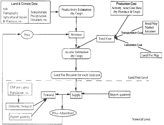
Fig. 1 Overall model framework
The agricultural productivity sub-,model calculates the potential productivity of the land unit for the given conditions of soil, topography, water availability and climatic parameters. The distribution is initially calculated for the rain fed conditions and are then suitably modified for the availability of irrigation. The main assumption of this sub-model is that there is a strong linkage between the climate and crop distributions. (Leemans). The crop yield estimation is derived from the method developed by the FAO in its project on the agro-ecological zones (Anonymous 1978). The central concept " of this approach is the growing period and the photosynthetic efficiency of the crops. The net biomass (Bn) is first calculated based on the aforesaid ,. methodology. The final yield (By) is then calculated as follows:
where, Hi is the harvest index, defined as the fraction of the net biomass of the crop that is economically useful (e.g. grain in cereals, sugar in . sugarcane, etc.)
The computations result in the climate based potential productivity distribution of the crops, assigning the values to each land unit. But to estimate actual potential production, soil characteristics are also of importance. Thus, the actual yield obtained in the above equation is modified based on the grid-specific soil conditions . "
The income estimation sub-model estimates the income per land unit from the yield related revenue and its cost of production. The model also accounts for the initial cost incurred in land conversion from other uses to agricultural lands.
The final step in the simulation is the land use decision module, which uses the estimated income & the existing landuse in the land unit under consideration as its input to predict the land use. We use the 'Profit Maximization Principle' as the guiding principle in deciding the land use for a ~ given land unit. As fluctuations in income over a short time-frame is quite t natural, we prescribe a range of income, instead of a certain fixed value, to determine the shift. The land use decision is revised based on the price r adjustment between the demand and supply for the various crops.
Results and Discussion:
In the estimation of the agricultural productivity, the value of the harvest index determines the economic yields of the respective crops. The harvest index depends on a number of factors like the genetic potential of the , crop -whether high yielding or low yielding and water regime -rainfed or irrigated. These are inherent to the crop variety in use and can be referred to as the unconstrained harvest yield index. But then, the level of agricultural inputs along with the soil conditions and topography also contribute to the harvest index at a given location, these can be referred to as the constraint factors. Then the harvest index (Hi) can be said to be a combination of the unconstrained yield index and the constraint factors. The harvest index ranges are given in the Table 1.
* Fresh Tuber at 35 percent dry weight
| Crop | Product | Harvest Index | Average Index |
| Phaseolus Bean(inc. Mung Bean) | Grain | 0.25-0.35 | 0.079 |
| Soybean | Grain | 0.30-0.40 | 0.151 |
| Rice | Grain | 0.25-0.35 | 0.259 |
| Cassava | Tuber | 0.50-0.60 | 0.766 |
| Maize | Grain | 0.30-0.40 | 0.198 |
| Sorghum | Grain | 0.20-0.35 | 0.108 |
In the model simulation of the agricultural productivity, the harvest index has been first estimated and then calibrated. The village based point data for Rice and Cassava were obtained for the crop year 1990-91 and these values have been used to calibrate the harvest index of these crops. The yield values were calibrated for other major crops from the provincial values of the yield. The average harvest indexes for all crops and rice are also shown in Table 1.
Based on the calibrated harvest indexes obtained, we calculated the distribution of the yields for all the. major crops and rice. Fig 2 shows the productivity distribution for rice. From these distributions of the productivities, were obtained the income distributions for three different cropping patterns, which was then compared with the land use patterns to determine the crop distribution. Fig 3. shows the distribution of the cropping patterns for the year of 1990.
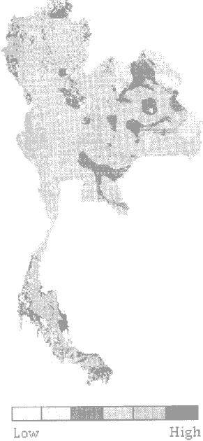
Fig 2. Productivity distribution of Rice
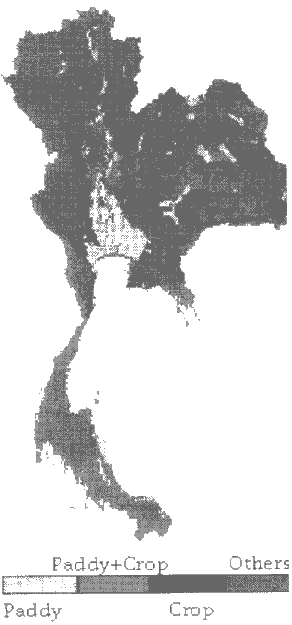
Fig 3. Cropping Pattern in 1990
Conclusion
The climatic-based crop productivity estimation relations were formulated. The results show that the determination of the harvest index plays a significant role in such relations. As such, efforts must be made to suitably modify this factor to take into account the additional agricultural inputs such as fertiliser ,etc to increase the yield. The quality of the datasets is of importance in these studies and so it is required to update the datasets to get a better understanding of the cropping patterns .
Reference
- Anonymous (1978), Report on the Agro-Ecological Zones Project. Food and Agricultural Organization of the United Nations, World Soil Resources Report 48, Rome.
- Rik Leemans and A.M. Solomon: Modeling the Potential Change in Yield and Distribution of the Earth's Crops under a warmed Climate: Climate Research Vol.3, 1993
- R. Leemans and G.J. van den Born: Determining the Potential Distribution of Vegetation, Crops and Agricultural Productivity: Water, Air and Soil Pollution Vo176, 1994
- Office of Agricultural Economics, Bangkok, Thailand. Agricultural Statistics of Thailand.