|
Change
Detection in Coastal Zone by Remote Sensing Technique
Mrs.
Valairat Wanpiyarat, Ms.Promchit Trakuldist, Mr. Boonrak
Pattanakanok
Land
Development Department,
Ministry of Agriculture and Cooperatives,
Thailand.
http://www.gisdevelopment.net/aars/acrs/1995/ps1/ps1012pf.htm
Abstract
Because
land use information was limited, therefore, the Landsat TM color
composites, band 432 (ROB) acquired on May 29,1989, and band 453 (ROB)
acquired on September 24,1991, and September 10, 1992, were visually
interpreted for land use changes detection in to the coastal area of 340
km 2 at Amphoe Pak Panang, Nakhon Sri Thammarat province. The results of
interpretation and field verification revealed that the increasing of
shrimp fans , during 2 the past three years, was up to 25.78 km due to the
encroachment of mangrove forest and land use change from paddy land to
shrimp fanning. Dispersed salt water, generated from shrimp fans, created
soil salinity and water contamination to the nearby paddy fields, resulted
in paddy abandonment. The total abandoned paddy field was found to be
17.80 kIn The coconut and banana area increased about 9.84 kIn2.
Approximately 13.63 kIn2 of the mangrove forest was destroyed and the
highest depletion area, 9.72 kIn 2 ,was found between the year 1991 and
1992.
In addition, the Landsat TM images also showed that the
coastal shore lines had been changed from year to year indicating the
usefulness of satellite image for update mapping.
I.
Introduction
The history of development of the Pak Phanang River
Basin has long been more than 10 years. The first real developmeilt
concept was created in 1980, with consideration of the Large-
Scale Project Section, the Project Planning Division, Royal
Irrigation Development. Up to now the serious problems in the Pak Phanang
River Basin can be described as
- Shortage
of fresh water for irrigation development and for domestic uses,
- Salt
water intrusion into the Pak Phanang River and tributaries which lasts
about 9 months each "year, causing shortages of fresh water into the
lower Pak Phanang basin,
- Conflicts
of interest between rice farmers and marine shrimp farmers due to
discharges of salt water from shrimp ponds into paddy fields, causing
damages of rice fields along the coastline of the Gulf of Thailand,
along the Pak Phanang River, and along the Khlong Cha Uad,
- Annual
flooding problems which usually occur in the period from November and
December reach year causing damages of houses, infrastructure, and
agricultural areas of more than 1 ,248 km
These
serious problems have to be mitigated, and this is the reason why it is
necessary to develop Pak Phanang River Basin.. His Majesty the King,
during his visits to Southern Thailand m 1992, gave the Royal Irrigation
Deportment his concept of building salt water barrage tat Ban Bung Pi,
Tambon Hulong, Amphoe Pak Phanang, Nakhon Sri Thammarat province as well
as a series of drainage canals in order to solve the above -mentioned
problems
In order to mitigate the conflicts between the rice
farmers and the shrimp farmers in the area, land use zoning delineation
between fresh water and saline water zone is very necessary Therefore, the
Department of Land Development. has carried out land use surveying,
emphasizing on land use changes in the paddy area and the mangrove forest.
Those existing land uses including the distribution of shrimp farms are
basically required for creation of reasonable dividing line.
2.
Study Area and Objective
The study area is located between 8 ° 15
to 8 30 N latitudes and 100 05 to 100 17' E longitudes covering about 340
km2 in the Pak Phanang River Basin , eastern side of Nakhon Sri Thammarat
province of the southern peninsula Thailand. Its physiography composes of
bays,Li sandy beaches, river mouth, dunes, and tidal flat. The north side
of the study area in the river mouth of the Pak Phanang River, is covered
with mangrove forest while the rest mostly contains agricultural land (
Figure 1 ).
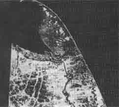
a.
May 29, 1989. Band 432
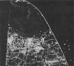
b.
September 24, 1991. Band 453
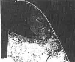
c.
September 10, 1992. Band 453
Figure 1. Landsat images of the study
area, acquiring on May 29, 1989, September 24, 1991, and September 10,
1992 respectively.
Remote
Sensing technology provides multiple, repetitive, and update physical
information. For this research, the authors aim to apply remote sensing
technology to monitor land cover and land use changes especially from
mangrove forest and or paddy to shrimp farm, and also estimate shrimp
fanning area in the study area.
3. Methodology
The
methodology includes an analysis of temporal Landsat TM images, field
verification, polygon overlay, and monitoring of land use changes.
An amount of three Landsat TM images, acquired on MultiMate
between the year 1989 and 1992 and produced at scale 1 : 50,000 was
visually interpreted for land cover / land use investigation. The
qualitative comparison of land use changes work during d1e period of d1ese
data.
To observe the circumstances, field verification was carried
out in May 1992 and September 1993. In the field, land cover land use,
forest condition, soil and water condition were described and recorded.
To study land cover land use changes, the multiple layers of
previous interpretation maps were overlaid to create new polygons showing
those changing areas. A number of changed polygons were examined and
calculated for reporting.
4. Result and Discussion
Analysis of Land Cover /Land Use
Land use
categories are distinguished on the color composite of Landsat TM band 234
and 354 ( BGR ), based on differences in color and texture. Those
categories are recognized as : paddy, mixed fruit tree, shrimp farm, built
up land, mangrove forest, marshland, and others. Paddy and mixed fruit
tree are the major agricultural crops in the area. Both irrigated and
non-irrigated paddy fields cover about 49 % of the total study area , 340
kIn 2. Mixed fruit trees area, is; coconut, banana, and orange, were found
to be approximately 7% in the year 1989. To identify the type of fruit
trees from Landsat TM images without field checking is impossible. Active
shrimp farming areas, along the coast lines, along the Pak Phanang River,
and in mangrove forest, are seen clearly from both combinations of Landsat
TM. Dense mangrove forest can be recognized as bright red color with fine
texture from the 234 combination and as peach color from the 354
combination. Amphoe Pak phanang is shown in bright blue color along both
sides of the Pak Phanang River which flows downward from the river mouth
to the south. The other land uses are i ~ marshland and abandoned paddy
which can be identified by utilizing temporal data.
Land Use
Change Analysis
An analysis of mechanisms of land use changes
plays an important role in forecasting environmental changes. As the
population increases, infrastructures develop, and economy blooms in the
study area and its vicinity , these cause changes in the coastal
environment and directly effect on the benefits of the farmers. Hence, we
consider the factors of land use changes in the study area from the view
point of human impact.
During the three years observed period, the
major land use changes are as follow:
- Changes
from paddy to shrimp farming,
- Changes
from mangrove forest to shrimp farming,
- Changes
from paddy to abandoned paddy.
Figure
1 shows all of those changes from the year 1989 to 1992. Results from
visual interpretation and field observation revealed that, during the year
1989 to 1991, paddy field had changed to be shrimp farm at the changing
rate of 9.1 % and this change had slightly decreased to be 7.1 % during
the year 1991 -1992. Shrimp farming expanded dramatically, at the
increasing rate of 116 % .in the year 1991, from mangrove forest
particularly in the north side of Amphoe Pak Phanang, to nearby paddy and
to paddy along the coastal zone. The shrimp farming area was found to be
40.43 kIn2 in the 1992 image while it was only 14.6 kIn2 in 1989. Salt
water, generated from shrimp farms, discharged into paddy fields causing
soil salinity and water contamination. These problems had affected
seriously to rice farmers by lowering rice yield to a very minimum,
therefore some of paddy fields were left abandon. The abandoned paddy area
increased from 6.1 kIn in the year 1989 to 17.89 kIn in the year 1992. In
the paddy fields and along stripped villages where were not affected by
salt water, farmers planted fruit trees, coconut and banana, and this area
rapidly increased approximately 9.84 km 2 within three years.
In
spite of forest plantation at Laem Pak Phanang, mangrove deforestation
still took place at due alarming rate due to shrimp farming. The destroyed
mangrove forest area was found approximately 13.63 km2 The highest
depletion occurred between due year 1991 and 1992 with the rate of 8.62 %
resulted in 9.72 km 2 loss.
In addition to due coastal land use
changes, due extent of shore lines changes could be observed from due
multi-temporal Landsat TM images. From due comparison among these images
and information obtained from topographic maps, the findings could be
summarized as follows :
- The
shore lines at the Pak Phanang River Mouth and along the Pak Phanang Bay
advanced toward the sea due to forest plantation.
- The
north spit at Laem Talumphuk extended in a north -west direction to some
extent ( Figure 1 ).
5.
Conclusion
Coastal
land use changes can be monitored using overlay monitored of
multi-temporal Landsat images. During the observed period of 1989,1991,
and 1992, the major changes have been observed as changes from paddy and
mangrove forest to shrimp farming as well as abandoned land. Rates of
these changes are determined and total shrimp farming area is calculated.
Shorelines movement is also detected from the study.
6.
Reference
- F.A.O.
1982. Management and Utilization of Mangrove in Asia and Pacific Region.
Environment Paper #3. Rome. F.A.O. ;
- F.A.O.
1984. Mangrove forests in Asia Pacific Region: A Summary of Available
Information. Bangkok. F .A.O.
- Pheng,
K.S. and Foo L.K. 1989. Detection of Land Use Changes Using Remote
Sensing and Proceedings of the Tenth Asian Conference on Remote Sensing.
November 23-
29,1989. Kuala Lumpur, Malaysia.
|