| GISdevelopment.net ---> AARS ---> ACRS 1995 ---> Poster Session 1 |
Monitoring Deforestation in
Luzon Island, The Philippines using Satellite Data
Akira Hirano, Genya Saito
and Nobuyuki Mino
National Institute of Agro-Environmental Sciences (NIAES)
3-1-1 Kannondai, Tsukuba, Ibaraki 305, Japan
Tel: +81-298-38-8225, Fax: +81-298-38-8199
Abstract
National Institute of Agro-Environmental Sciences (NIAES)
3-1-1 Kannondai, Tsukuba, Ibaraki 305, Japan
Tel: +81-298-38-8225, Fax: +81-298-38-8199
A comparison was made between a land use map derived from remote sensing data and an existing land use map. A GIS (Geographic Information System) was implemented to evaluate the land use change of Carmiling district, Luzon .island, the Philippines. Deforestation in the study area was evaluated. Soil Vegetation matrix method was used to create land use map from MOS-l/MESSR data. Two satellite data taken during the dry season and the rainy season, respectively, in the study area were used to make the classification more accurate.
Following procedures were taken for both satellite images taken during the dry season and during the rainy season in 1990. Pixels of the image were classified according to their VCR (Vegetation Coverage Ratio) and SDI (Soil Dryness Index) using a matrix. Classified images derived from two different seasons were then logically related to each other to , generate the satellite-derived land use map. Land use information was extracted from an existing topographic map in, published in 1977. The information was then input to a GIS (Geographic Information System). Land use maps of two different times were logically overlaid onto each other to evaluated the land use change : happened during the period. Clear decrease in forest area, namely deforestation was monitored. Forest area in the Camiling district was about 457 km2 in 1977, whereas it was about 246 km2 in 1990. It had shrunk by about 48 percent. Spatial analysis showed that 45 percent of the ex-forest area turned into paddy field.
1ntroduction
Recent deforestation in Asia has come to be one of the most pressing environmental problems. The major causes of deforestation in Asia are commercial logging, shifting cultivation, transmigration, acquiring of fuel woods, forest fire, agricultural development, resort development, mining and urbanization. Deforestation leads such deterioration of natural conditions as follows (Murai, 1991):
- Run off ratio increases resulting in flash flood.
- Water level and volume of ground water decline.
- Wild animals and species become extinct.
- Soil eroded or degraded.
- The climate may change to dry weather condition; characterized by less rainfall, higher f temperature and more evaporation.
However, current digital classification technique has not sufficient accuracy for operational utilization. Using two independent parameters derived from the information on vegetation coverage and soil dryness provides us with higher accuracy in classifying land use patterns. Cross-examination of two data sets from different seasons can raise the classification accuracy.
2. Study Area
Camiling district was selected as the study area to evaluate a typical deforestation in the Philippines. The study are is located at western-central part of Luzon island, It is about 150 km northwest of Manila City, The area covers about 25 km east to west, 27 km north to south and encompasses approximately 675 km2o The area is located at the eastern foot of Zambales mountains, land use is mainly paddy field and tropical forest, Terrain consists of relatively flat alluvial plain and steep mountain slope with elevations ranging from 20 to 1180 meters (Figure 1)

Fig.1 The Study area (Camiling district, Lluzon island, the Philippines).
3. Data
3.1 Satellite data
Two MOS-l/MESSR data (Path-Row : 29-98W) that cover the western central part of Luzon island taken during the dry season (February 1, 1990) and the rainy season (October 31, 1990) were utilized to create the land use map, These satellite images include the study area.
In order to minimize the effects of sun elevation when comparing the data obtained in different seasons, radiometric correction was applied to these multi-temporal images, Each CCT value in the image was divided by sin ?, where ? is the sun elevation at the date when the satellite data were acquired. The images were then geo-coded to UTM coordinate system. Geo-coding was performed using 1:50,000 scale topographic maps published by NAMRIA (National Mapping & Resource Information Authority.
3.2 Existing map
As for the existing map, topographic map at a scale of 1 :50,000 compiled and published by NAMRIA in 1977 was utilized.
4. Analysis and Discussion
4.1 Land use classification procedures using soil /vegetation matrix method
Using soil/vegetation matrix method, pixels in the satellite image were classified according to their vegetation coverage and to their soil dryness. The procedures are described as follows.
4.1.1 Vegetation Index
To evaluate the vegetation coverage information, K-Vegetation Index (KVI) was utilized. KVI is a vegetation index based on reflectance of vegetation in near IR wavelength as shown schematically in Figure 2 (Yoshida et al. 1993). KVI is given by
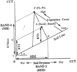
Figure 2 Conceptual figure of KVI, VCR, and SDI
where a and b are constants. Here a is obtained from the slope, and b is the y-segment of the least square line fit through the data points that constitute the description of bare soil on the scatter plot of ...band 2 versus band 4. This regression line is conventionally called the Soil Line. Band2 and Band3 are the CCT (computer compatible tape) values of the pixel concerned at MOS-l/MESSR band 2 (Red: 610-690 nm) and band 3 (IR: 800-1100 nm), respectively. Using KVI, Vegetation Cover Ratio (VCR) was then calculated for each pixel to estimate the proportion of vegetation coverage to the area of the pixel concerned. VCR is given by
where KVI max is the maximum value of KVI recorded in the image of the study area. VCR of any pixel on the Soil Line is equal to 0 for there is no vegetation on these pixels. Pixels in the image were classified into 5 levels according to their VCR values from high to low.
4.1.2 Vegetation Cover Ratio
To evaluate the soil dryness information, Soil Dryness Index (SDI) was utilized. SDI, referred to as Soil Index (SI) by Fukuhara et al.(1979), is sensitive to the soil brightness, which depends on soil moisture and soil organic matter conditions. SDI is given by
| SDI=arctan | P4-Band4 ------------------ Band2-P2 |
(3) |
where P2 and P4 are the x-coordinate (Red) and the y-coordinate (NIR) of the pixel that has the maximum vegetation coverage, respectively. The higher the SDI value of a pixel, the drier the soil of the pixel is. Pixels were classified into 5 levels according to their SDI values from high to low.
4.1.3 Soil/vegetation matrix method
Each pixel was distributed over 5x 5 matrix of VCR and Sill, and they were classified into 8 classes according to their land cover conditions (Figure 3).

Figure 3. Soil/vegetation matrix according to VCR and SDI
4.1.4 Re- classification
Soil/vegetation matrix method was carried out to both images taken during the dry season and the rainy season that resulted in two sets of land use/land cover classified images. Using GIS overlay function, these two images were cross-examined to generate a re-classified land use map to make the land use classification more accurate. Classification classes were determined in order to keep the consistency with the classes derived from the existing map. Those are (1) Water, (2) Fish pond, (3Bare soil, (4) Upland farming field, (5) Paddy, and (6) Forest.
Land use information was extracted from an existing topographic map compiled and published NAMRIA in 1977. In order to maintain the consistency with the satellite-derived land use map, land use information was digitized with the aid of GIS software so that overlay analysis can be carried out. ..At the same time, major roads and rivers in this area were also digitized to make the geographical registration easier
4.3 Land use change analysis
Satellite-derived land use map and the land use map derived from the existing map were input into a GIS to perform an overlay analysis in order to detect the land use change happened between 1977 and p 1990. With the help of GIS, spatial distribution of land use change was also detected. Distinct deforestation as monitored during the period. Considerable amount of forest area deceased by. nearly half (Figure 4). Of4.6 x 102 km2 of forest area ill 1977,2.1 x 102 km2turned into paddy ill 1990. This explains 93.9 percent of the total loss of forest area (Figure 5).

Figure 4. Land use change for settlement, bare soil, paddy, upland field, and forest: 1977 to 1990.
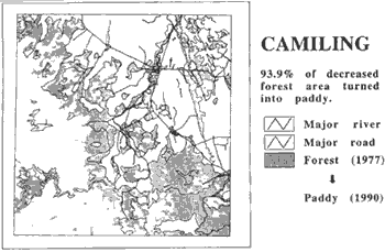
Figure 5. Spatial distribution of land use change ( Forest (1977) Paddy (1990))
5. Conclusion
Deforestation in Luzon island, the Philippines was monitored and evaluated both numerically and spatially with the help of soil/vegetation matrix method and GIS technique. From 1977 to 1990, a considerable amount of forest area turned into paddy in the study area. Soil/vegetation matrix method, a land use classification method using the information on vegetation coverage and on soil dryness is effective to generate a land use map from satellite data. Using two sets of satellite data acquired during the dry season and the rainy season, respectively, makes the classification accuracy higher
Acknowledgments
Part of this study was made as the cooperative work with National Space Development Agency (NASDA) of Japan. The authors are grateful to NASDA for providing the MOS-1/MESSR data
References
- Fukuhara, M., Hayashi, H., Yasuda, Y., Asanuma, I., Emori, Y., and Iisaka, I., "Extraction of soil information from vegetated area., Machine Processing of Remotely Sensed Data Symposium, pp.242-252., 1979.
- Murai, S., "Application of remote sensing in Asia and Oceania. -Environmental change monitoring (Asian Association on Remote Sensing: Murai, S.), 1991.
- Yoshida, M., Rondal, D.I., Evangelista, M.A.M., and Saito, G., "Land-use/Land-cover analysis by the matrix method using remote sensing", Asian-Pac. Remote Sensing J., Vol.5, pp.79-84, 1993.