| GISdevelopment.net ---> AARS ---> ACRS 1995 ---> Poster Session 1 |
Satellite Remote Sensing for
Artificial Grassland in Japan
Nobuyuki Mino, Genya Saito,
and Akira Hirano
National Institute of Agro-Environmental Sciences
3-1-1, Kannondai, Tsukuba, Ibaraki, 305, Japan
TEL: (81)-298-38-8225
FAX: (81)-298-38-8199
E-mail : minonobu@niaes.affrc.go.jp
Abstract National Institute of Agro-Environmental Sciences
3-1-1, Kannondai, Tsukuba, Ibaraki, 305, Japan
TEL: (81)-298-38-8225
FAX: (81)-298-38-8199
E-mail : minonobu@niaes.affrc.go.jp
Spatilal information on grassland status is required for various grassland managements. Field survey costs much labor and time, but, satellite remote sensing can provide wide areal information of grassland efficiently. In this study, we attempt to monitor annual change of grassland and grass-renovation status using multi-temporal satellite data. As results of annual change analysis, for satellite data acquired in May, an increase trend in visible, near-infrared, middle-infrared reflectance with aging after grass-renovation was observed. We considered that the change in reflectance is due to the accumulation of dead plants on ground surface. On the other hand, for satellite data acquired in June, a sudden decrease in near-infrared, middle-infrared reflectance was observed approximately in 4 years period after grass-renovation. We considered that the change in reflectance is due to the change of grass- species composition. Then, we compile 'Grass-renovation years map (1985-1994) by extracting 1-year grassland and renovated grassland from each satellite data. Renovation-years from satellite data agreed with that from ground survey with high accuracy. Those results show that great ability of satellite remote sensing to monitor grassland status.
1. Introduction
In Japan, grassland is managed intensively for mowing or grazing. Grassland just after seeding has high productivity, but, to maintain it for many years is very difficult. To maintain high productivity of grassland, proper management should be conducted according to various conditions of grassland. Especially, annual change of grassland affect grass-yield seriously, so that it is a key item to be monitored for grassland management.
Once grassland productivity decreases, grass-renovation which is accompanied with plowing and seeding needs to be conducted to improve its productivity. Passed years after grass-renovation is one of indices which indicate grassland productivity. So, grass-renovation year is very important for grassland management.
Since, grassland covers wide area, field survey costs much labor and time to collect spatial information of grassland status. Satellite remote sensing can collect a wide range of spatially distributed information efficiently. If satellite remote sensing can be used for grassland monitoring, it will be an effective tool for various managements. In this study, we attempt to monitor annual change of grassland and grass- renovation status using multi-temporal satellite data.
2 Method
(1) Study site
Study site is Konsen area which is a major dairy farming region in northern part of Japan (Fig. 1). Due to the low temperature and insufficient sunlight in summer, agricultural lands in this area is not suitable for crop except for grass. In study site, more than 97% of agricultural lands is grassland. Usually, grasslands in study site are mowed in June and August, or are grazed from May to September.
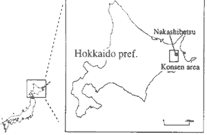
Figure 1 Study site (Konsen area in Hokkaido pref.)
(2) Satellite data
As for satellite data, we collected LANDSATRRM, MOS-1/MESSR, JERS-1/SAR acquired during 1985-1994. (Table 1. ) Geometric correction was applied to the original images and a pixel size of 25m by 25m was used.
| Path-Row Sensor Date | Path-Row Sensor Date |
| 106-30 TM 85.05.24 106-30 TM 85.07.27 106-30 TM 85.06.28 106-30 TM 86.07.30 105-30 TM 87.05.07 19-59E MESSR 88.06.06 105-30 TM 89.05.19 105-30 TM 89.06.13 19-59E MESSR 89.08.22 106-30 TM 90.04.20 106-30 TM 90.06.07 106-30 TM 90.07.02 106-30 TM 90.08.03 |
106-30 TM 91.04.23 106-30 TM 91.06.26 106-30 TM 91.08.29 105-30 TM 92.04.09 106-30 TM 92.06.28 106-30 TM 92.08.24 105-30 TM 93.04.21 105-30 TM 92.06.28 105-30 TM 94.05.17 59-227 JERS-1/SAR 92.4.15 59-228 JERS-1/SAR 92.4.15 |
(3) Extraction of grassland
Since study site contains forest, cropped area, urban area except for grassland, we produced a file to mask those using some kinds of satellite data. For masking cropped area and urban area, we used multitemporal LANDSATRRM data. For masking forest, we used JERS1/SAR data. In this study, we analyzed annual change of grassland and grass-renovation status on the portion except for masked area.
(4) Annual change of grassland
For the study of reflectance annual change, there is a method to compare multi-temporal satellite data directly. However, both observation dates and annual difference of grass growth may affect grassland reflectance. Therefore, direct comparison among multi-temporal satellite data can not supply the information about annual change of grassland reflectance. In this work, using the characteristics of grassland just after renovation, we study annual change of grassland reflectance.
Once grassland productivity decrease, grass-renovation which is accompanied with plowing and seeding needs to be conducted to improve its productivity. Since bare soil is appeared on grassland just after renovation in growing season, such grassland can be distinguished easily from the other grassland coverage using satellite data. (Fig. 2) Using multi-temporal satellite data, we can compile a map which contains spatial distribution of grass-renovation status. Here, we extracted grassland just after renovation according to thresholds of each data, overlaied those and call it "grass-age standard map". By overlaying this map and individual satellite image, we can compare the different age grassland with each other on one satellite image (Fig. 3).
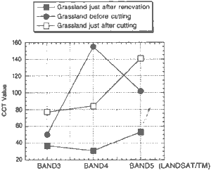
Figure 2 Reflectance characteristics of grassland just after renovation
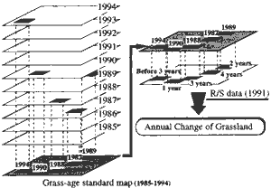
Figure 3 Conceptual figure of annual change analysis
Suppose we have satellite data acquired from 1985 to 1994 and we are analyzing the satellite data of 1991. For grassland coverage which renovated in 1990, we can extract 1-year old grassland reflectance. the same way, for grassland coverage which renovated in 1989, we can extract 2-years old grassland reflectance. Further, using 1988, 1987, 1986, 1985 satellite data, we can extract reflectance of 1-year to 6-years old grassland. Such comparison is seemed to be annual change of grassland reflectance. Using this method, we study annual change of grassland reflectance in LANDSATRRM data acquired in May and June respectively. The grass-age of annual change which was made clear in this study are listed in Table 2.
| Satellite data | 1993.6.8 | 1992.6.28 | 1991.6.26 | 1990.6.7 | 1989.6.13 | 1994.5.17 | 1989.5.19 |
| Grassland age | 1 year 2 year 3 year 4 year 5 year 6 year 7 year 8 year 1 year before renovation |
1 year 2 year 3 year 4 year 5 year 6 year 7 year 1 year before renovation 2 year before renovation |
1 year 2 year 3 year 4 year 5 year 6 year 1 year before renovation 2 year before renovation 3 year before renovation |
1 year 2 year 3 year 4 year 5 year 1 year before renovation 2 year before renovation 3 year before renovation |
1 year 2 year 3 year 4 year 1 year before renovation |
1 year 2 year 3 year 4 year 5 year 6 year 7 year 8 year 9 year |
1 year 2 year 3 year 4 year 1 year before renovation 2 year before renovation 3 year before renovation |
(5) Grass-renovation status (1985-1994)
"Grass-age standard map" above mentioned has spatial information of grass-renovation. But, this map does not detect grass-renovation after satellite observation in the year. And, it does not detect grass renovation 1-2 months before satellite observation in the year. So, extracting 1-year grassland from satellite data in addition to grassland just after renovation, we catch grass-renovation status of each year .Be-sides, we produce "grass-renovation years map (1985-1994)" by overlaing grass-renovation map of each " year.
3. Results and discussions
(I) Annual grassland change in May data
For satellite data acquired in May, an increase in visible, near-infrared, middle-infrared reflectance with aging was observed. (Fig. 4.)
Figure 4 Annual change of grassland feflectance in Landsat TM data acquired in May
In May, grass-field is covered with only a little vegetation. For satellite data acquired in May, reflectance of grassland is dependent on that of its background. On the ground, that is the background of grass- land, an increase of dead leaves accumulation with aging was observed. Accumulation of dead leaves on the ground is a very little on the grassland just after renovation, or young grassland. Whereas, old grassland accumulation of dead leaves on the ground has a lot of amount. Dead leaves present bright color. Therefore, ground surface on which the accumulation of dead leaves exists appear to be brighter than ordinary bare soil. We considered that an increase in visible, near-infrared, middle-infrared reflectance with aging is due to the accumulation of dead leaves on ground surface. (Fig. 5)
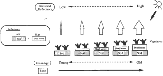
Figure 5 Conceptual figure about annual change of grassland reflectance in data acquired in May
(2) Annual grassland change in June data
For satellite data acquired in June, a sudden decrease in near-infrared, middle-infrared reflectance was : observed approximately in 4 years period after grass-renovation, while, visible reflectance maintain its : constant value. (Fig. 6.) .
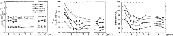
Figure 6 Annual change of grassland reflectance in Landsat TM data acquired in June
June is just before harvest season. Grass-field is covered with much vegetation. In June, grassland reflectance is considered to be dependent on its vegetation. In some previous field survey studies about P, annual change of grassland vegetation in Konsen area, the change of grass-species composition with aging had been reported. As a major change, it is reported that clover crown cover suddenly decreases and ordinary grass occupied mainly in approximately 4 years period after grass-renovation.
The decrease trend of near-infrared and middle-infrared reflectance and the decreasing trend of clover crown cover are similar .There is a structural difference between clover and grass, clover has a horizontal leaf angle distribution whereas grass has vertical. This means that for a given area and biomass clover may have higher reflectance than grass. Therefore, it is considered that young-age grassland with much clover crown cover has higher reflectance than old-age grassland with ordinary grass. From those, we considered that the major factor of the sudden decrease of reflectance is due to the change of grass-species composition with aging. (Fig. 7.)
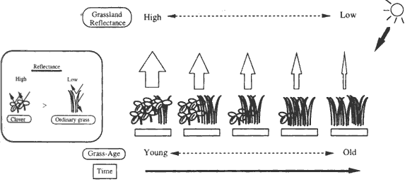
Figure 7 Conceptual figure about annual change of grassland reflectance in data acquired in June
(3) Grass-renovation status (1985-1994)
The results show that grass-renovation was conducted every year for about 7% of grassland in study site, However, on 1987, 1994, due to limitation of satellite data acquisition, we can not detect grass-renovation enough, Ground survey reported that grass-renovation percentage of total grassland in study site is 7 - 8%. And, grass-renovation year of the map from the satellite data agree with that of ground survey on about 80% grassland. (In some cases, plowing year and seeding year do not agree. In this accuracy assessment, we regard it as agreement that renovation year from satellite data was 1-year prior to the year from ground , survey, ) Those results show satellite remote sensing is very useful for survey of grass-renovation status
| year | grass-rrenovation percentage of total grassland (%) |
| 1985 1986 1987 1988 1989 1990 1991 1992 1993 1994 |
7.1 7.5 5.5 7.1 8.6 6.7 7.0 7.5 7.0 4.9 |
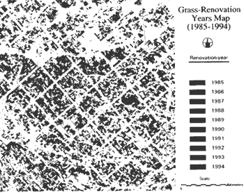
Figure 8 Grass-renovation years map (1985-1994)
In this work, we study annual change of grassland reflectance and grass-renovation status using multi-temporal satellite data, Those results show satellite remote sensing can distinguish different-age grassland, and also is so useful for grass-renovation survey. We concluded that satellite remote sensing will be an effective tool for grassland management.