| GISdevelopment.net ---> AARS ---> ACRS 1995 ---> Poster Session 1 |
Classification Of Forest In
Malaysia Using Jers-1 Sar And Landsat Tm Data
Hideki Saito1,
Khali Aziz Hamzah2 and Haruo Sawada
1Forestry and Forest Products Research Institute
P.O. Box 16 Tsukuba Norin Danchi, Tsukuba Ibaraki 305, Japan
Tel: 0298-73-3211 ext. 636 FAX: 0298-73-3799
E-mail :rslsaito@ffpri.affrc.go.jp
2Forest Research Institute of Malaysia
Kepong, Kuala Lumpur 52109, Malaysia
Tel: 03-6342633 FAX: 603-6367753
E-mail :khali@frim.gov.my
Abstract 1Forestry and Forest Products Research Institute
P.O. Box 16 Tsukuba Norin Danchi, Tsukuba Ibaraki 305, Japan
Tel: 0298-73-3211 ext. 636 FAX: 0298-73-3799
E-mail :rslsaito@ffpri.affrc.go.jp
2Forest Research Institute of Malaysia
Kepong, Kuala Lumpur 52109, Malaysia
Tel: 03-6342633 FAX: 603-6367753
E-mail :khali@frim.gov.my
We can get SAR images in both wet and dry seasons, as they are available in all-weather. In addition, SAR observes objects with the same energy, thus we can compare any SAR images that are acquired at different time directly. These characteristics are effective for monitoring a forest in Malaysia that is often covered by cloud and has different condition due to seasons. The purpose of this study is to improve the classification accuracy of forest area in east coast Malaysia using JERS-1 SAR data and Landsat TM data. However SAR data alone is not enough for obtaining good result on forest classification. Therefore we attempted to combine SAR and TM data for the classification. Their results are as follows; (1) The classification accuracy of peat swamp forest, hill forest and grass land are improved, (2) It is effective to use average filtered image of SAR, (3) It is also effective to use two SAR data that are acquired in different seasons. Combining TM and SAR data is quite useful for the classification of forest in Malaysia. These results indicate that SAR is closely related to the forest volume and structure of forest in Malaysia. This point must be the subject of future research.
1. Introduction
Lately, decreasing and degrading of tropical forest have become important problem at not only local or regional level but also global level. Remote sensing technology has been available for monitoring tropical forest. Spatial and spectral resolutions of Landsat TM are so high that it is suitable sensor for monitoring of tropical forest. But it is restricted to acquire the observation data, because optical sensor, such as Landsat TM and SPOT HRV, were obstructed by cloud. Compared with these sensor, SAR has some advantages in observing the forest. (1) SAR data is possible to be acquired in both dry and wet seasons, as it is available in all-weather. (2) SAR observes objects with the same energy, thus we can directly compare SAR images that are acquired at different time. Thus these characteristics allow us to monitor tropical forest periodically. (3) L-band SAR digital number and forest volume have deep relationship, since it can penetrate the canopy layer and is reflect by forest floor and tree stem or branch (L. L. Hess, 1990). There is a study about classification using Landsat TM together with ERS-1 SAR. It says that the combination of Landsat TM and ERS-1 SAR data can ~ potentially lead to improved land cover mapping (R.P.H.M. Schoemakers et al., 1993). It is considered to be admitted that the combination of Landsat TM and JERS-1 SAR can improve the classification accuracy.
2. Study Area and Data
A test site was selected in forest area in the south part of Pekan village (102 30'E, 3 30'N), Pahang in the east coast of Peninsular Malaysia. Peat swamp forests are major occupation in this area and ii oil palms are planted around peat swamp forest. The topology is flat, especially in the peat swamp forest. The weather is seasonal tropical climate, and temperature keeps high and it has small seasonal changes. Both wet and dry seasons are found in this area. Monthly temperatures and monthly mean precipitation at Kuantan, Pahang, MALA YSIA are represented in Figure 1 and 2 (NOAA, 1987-1994). Kuantan is northern part of Pekan and distance between both towns is about 50 km. The data that were used in this study are represented in Table 1.
| Satellite | Sensor | Path -Row | Acquisition | Season |
| Landsat | TM | 126-58 | 24 June, 1992 | Dry Season |
| JERS-1 | SAR | 118-29 | 17 July, 1993 | Dry Season |
| ERS-1 | SAR | 118-29 | 13 October, 1993 | Beginning of Wet Season |
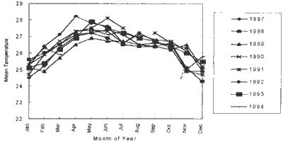
Figure 1 Monthly Mean Temperature of Kuantan, Malaysia
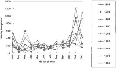
Figure 2 Monthly Precipitation of Kuantan, Malaysia
3. Methodology
3.1 Reducing Speckle Noise
To minimize effects of speckle noise, a median filter is applied to SAR image. The median filter can remove very high or low values in its windows, so it is expected to reduce the effect of speckle noise. The window size of that filter was 5 by 5.
3.2 Overlay
Both of SAR data were overlaid to TM data and the pixel spacing of both was set to 30 m, the pixel size of TM data, using nearest neighbor interpolation as a resampling method.
3.3 Texture Analysis of SAR
The statistical values such as average and standard deviation of the gray level histogram of n by n windows can be used as a textual information (J. A. of RS, 1993). Average and Standard deviation filter of 5 by 5 windows were applied to median filtered SAR image to get textural information of SAR in this study.
3.4 Normalized Difference Vegetation Index (NDVI) of TM
NDVI are calculated by following expression;
NDVI shows as a high value for denser vegetation, while NDVI very low in desert, or non-vegetation region (J.A. of RS, 1993).
3.5 Maximum Likelihood Classification
First, Training areas were selected referencing field survey and interpretation of Landsat TM image. Then Training data sets that contain 13 classes were extracted. Second, We generate 9 sets of combination of TM, NDVI and SAR for comparing the classification accuracy. These combinations are shown on the first line of Table 2. Band 1 of TM is strongly affected by path radiance and band 6 1 is the thermal band. Therefore these bands were not used in this study.. third, the Maximum likelihood classification was executed for each set using above-mentioned training data sets. Finally, we evaluated the accuracy of each classification by the Mapping accuracy that was calculated from con-fusion matrix.
| TM2 3 4 5 7 | TM2 3 4 5 7 + NDVI | TM2 3 4 5 7 + SAR07 | TM2 3 4 5 7 + SAR07ave | TM2 3 4 5 7 + SAR10ave | TM2 3 4 5 7 + SAR07ave + SAR10ave | |
| Swamp Forest | 0.00 | -1.23 | 1.72 | 12.18 | 7.56 | 15.15 |
| Disturbed Swamp Forest | 0.00 | -0.87 | 1.16 | 2.72 | 3.88 | 5.72 |
| Swamp Forest (Bright) | 0.00 | -0.43 | 1.24 | 6.47 | 5.90 | 8.59 |
| Swamp Forest (Dark) | 0.00 | -0.47 | 0.87 | 5.02 | 3.66 | 6.62 |
| Oil Palm | 0.00 | -0.31 | 0.49 | 1.99 | 4.97 | 5.79 |
| Oil Palm (Young) | 0.00 | -1.63 | 3.28 | 10.13 | 5.60 | 11.07 |
| Oil Palm (New) | 0.00 | -1.01 | 1.19 | 2.74 | 1.19 | 3.99 |
| Bush | 0.00 | -1.46 | 0.60 | 4.77 | 1.97 | 6.22 |
| Hill Forest | 0.00 | -0.90 | 2.29 | 5.46 | 3.40 | 10.59 |
| Disturbed Hill Forest | 0.00 | -2.80 | 1.37 | 5.74 | 3.45 | 6.34 |
| Bare Soil (White) | 0.00 | 0.39 | 0.20 | 0.54 | 0.17 | 1.23 |
| Bare Soil (Red) | 0.00 | -0.37 | 0.11 | 0.08 | 0.04 | 0.25 |
| Grass Land | 0.00 | 0.00 | 0.98 | 4.00 | 4.57 | 8.16 |
| Average accuracy | 0.00 | -0.85 | 1.19 | 4.76 | 3.57 | 6.90 |
| "Bright", "Dark, "White" and "Red" represent colors on Landsat TM image (R:G:B = 543). | ||||||
| "SARO7" means median filtered SAR data acquired at 17 July, 1993. | ||||||
| "SAR 07ave" means average filtered data on median filtered SAR data acquired at 17 July 1993. | ||||||
4. Results and Discussion
The results of classification of each class, which were evaluated by Mapping accuracy, are represented in Figure 3 and their improving rates are shown on Table 2. It is clear that classification of TM "data alone, their improving rates are in order of the number of bands that were used in classification. In the case of the combination of TM and NDVI, classification accuracy was slightly decreased in al- 8 most classes. An improvement of classification accuracy could not find in the case of the combination of TM and median filtered SAR. These results carried out that we cannot improve the classification accuracy combining TM and original SAR or median filtered SAR images. Original SAR data are not suitable for classification, because there are many speckle noises in this image. Median filtered SAR image also cannot be used for classification, because it still has many speckle noises. Classification accuracys are improved in the case of the combination of TM and the textural data of SAR. We got textural data from applying the average and the standard deviation filter on median filtered SAR image. Average filtered image was more effective for improving of classification accuracy than standard deviation filtered image. Average filter on median filtered image has very strong effect to reduce the speckle noise, however this process has some problem such as destroying edge and c line feature. Classification accuracys were improved in almost classes, especially classes of peat swamp forest and grass land are improved more than any other classes. For class of bare soil significant Improvement, could not be found, because those classes have high accuracy without SAR data. It seems that these results reflected the characteristics of SAR on the information concerned with forest volume and structure.
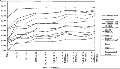
Figure 3 Relations between Mapping Accuracy and Band Combination
Combining TM and two SAR that were acquired in different seasons, classification accuracys were improved more. One SAR image was acquired in July (Dry season) and another one was acquired in October (Wet season). The changes of SAR digital numbers of each class are shown in Figure 4. This figure indicates that SAR digital number of swamp forest classes is decreased and the other classes have no change or increase. It is considered that these differences are caused by the difference of the hydrological condition between both seasons. Especially, peat swamp forest is strongly affected by flooding in wet season. L. L. Hess et al. mentioned about detection of flooding on forested floodplain by SAR remote sensing. They summarized as followed; Synthetic aperture radar remote sensing is a promising tool for detection of flooding on forested floodplain. The bright appearance of flooded forest on radar images results from double-bounce reflection between smooth water surfaces and tree trunks or branches. Enhanced backscattering at L-band has been shown to occur in a wide variety of forest types. Lack of enhancement is a function of both stand density and branching structure (Laura l. Hess et al., 990). We can find a suggestion here that L-band can detect the flooding in the forest as a bright appearance. However it is not useful in dense forest, because L-band cannot penetrate dense canopy. In this study the relationship between differences of SAR digital number and seasonal changes of backscattering properties of peat swamp forest have not been clear. But his result indicates that SAR may observe seasonal change of pat swamp forest.
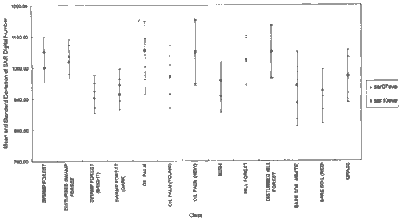
Figure 4 Mean and Standard Deviation of SAR Digital Number in Each Classes
Tropical peat swamp forest accumulates a large quantity of carbons in not only terrestrial part but also subterranean part as a peat that contains a litter and methane, even though that area is not so large (Furukawa, 1985). Therefore the mapping and monitoring of peat swamp forest are important for not only local environment but also global environment. However Field survey is difficult in peat swamp forest, because flooding and thick tangles of stems and roots prevent us from going into forest. Results of this study allow us more accurate mapping of forested area such as peat swamp forest using Landsat TM and JERS-1 SAR data and continuous monitoring al the year round using JERS-1SAR.
References
- Furukawa Hisao and Supiandi Sabiham, Agricultural Landscape in the Lower Batang Hari, Sumatra Part 1, Southeast Asian Studies Vol. 23, No 1, pp 3-37, 1985
- NOAA, Monthly Climatic Data for the World, NOAA, Vol. 40-47, 1987-19943
- Laura L. Hess, John M. Melack and David S. Simonett, Radar detection of flooding beneath the forest canopy: a review, INT J REMOTE SENSING, Vol. 11, No 7 pp. 1313-1325, 1990
- Japan Association on Remote Sensing, Remote Sensing Note, Japan Association on Remote Sensing, 284 pp., 1993
- R.P.H.M. Schoenmakers, G. G. Wikinson and Th. E. Schouten, Use of Landsat TM Image Segmentation for Smoothing ERS-1 SAR Imagery in Combined Multi-sensor Landscape Classification, International Geoscience and Remote Sensing Symposium (IGRSS'93), pp. 1228-1230,1993.