| GISdevelopment.net ---> AARS ---> ACRS 1995 ---> Mapping from Space |
An Archaeolgical Application
of synthetic Radar (SAR) in Thailand
Tsuneaki
Shimoji
Assistant professor Dr. Punnee Wara-aswapati chair of remote sensing,
Suranaree university of technology nakhon ratchasima 30000,Thailand
Tel ./Fax :66-44-216101
E-mail: punnee@sural.sut.ac.Th
Abstract Assistant professor Dr. Punnee Wara-aswapati chair of remote sensing,
Suranaree university of technology nakhon ratchasima 30000,Thailand
Tel ./Fax :66-44-216101
E-mail: punnee@sural.sut.ac.Th
An archaeological site has been identified in northeastern Thailand using airborne Synthetic Aperture Radar (SAR) . The site consist of a pair of concentric ancient moats or canals which one surrounded an ancient town called "Muang Ham Hork " Near Ban Rai, Tambol Ban Khwao,Aamphoe Ban Khwao, Changwat Chaiyaphum. The siteenclosed by the moat is approximately 1.6Kmin diameter.It is estimated that the site dates from the Dvaravati period (1,200-1,600 BP). Today, the site is covered by cultivated land , and now only a few earth wall and moats remain in the eastern part of the town. A part of a high wall or gates appears in the south ,where a red sandstone Buddhist altara with the size of 2 m . 0.60m .*0.30m .was found on the top of the remaining wall , and broken pottery was also found at the area of the site .
The SAR data was collected by the Canada Center for Remote Sensing Convair 580,as part of the joint Canada-Thailand Globe SAR Program .globe SAR is designed to develop SAR expertise in a number of countries around the world, prior to the launch of Canada's Radarsat in 1995. Due to the characteristics of radar, in particularity capability to distinguish between adjacent areas with slightly different levels of soil moisture, it is a most effective in identifying sites such as this one, in tropical or sub-tropicalenviornments. While archaeology was not the prime objective of the GlobeSAR program in this region , the unexpected results will add considerably to Thailand's archaeological inventory. It is planned to review the SAR data from all eight sites in Thailand to determine whether or not other sites or features can be identified.
1.Introduction
Changwat Chaiyaphum, has been a land of civilization since prehistoric times, and more recently since about the 12th Buddhist century, as seen from various Dvaravati type evidences. Most of these traces consist of the "sema" leaves found usually in groups, such as the sema group at Bn Kut Tum, Amphoe Muang, Changwat Chaiyaphum. Later times saw the spread of khmer civilization, as khmer type architecture such as prang ku, Amphoe Muang, Chaiyaphum, attest [1].
Among the ancient towns of Chaiyaphum, there is one obvious circular shape of an archaeological site, about 20 km. Southwest of Changwat Chaiyaphum , in Amphoe Ban Khwao, Tambol Bn Khwao near Ban Khwao near Ban Rai, where the ancient town situates, it was named Muang Ham Hork.
2. objective
The objective of this research are:
2.1 To study the ability of synthetic aperture radar (SAR) to detect an archaeological site and it's present land use for the purpose of management and planning.
2.2 To develop and transfer the technology acquired from joint research at the national institutions and CCRS, involving the use of airborne and space borne C- Band SAR data to those engaged in land use management.
2.3 To develop training materials in cooperation with national and regional institution s to promote "SAR Literacy" among professionals and technical staff, both those participating in Globe SAR and others in the region.
3. study Area
The study ea is the test site TH-1 Chaiyaphum. Changwat Chaiyaphum is a land of ancient cities and towns in Korat plateau, Northeastern Thailand. It situates in 150 48 ' 17.5" latitude North and 1020 02' 17.5" Longitude East, with the area of 11,778.287 km2 and 342 km from Bangkok is shown in figure 1.
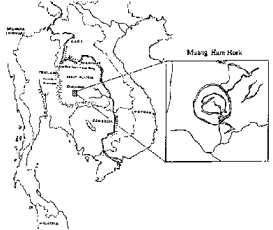
Figure 1: The study area: Test site TH-1: Chaiyaphum
4. Materials and Data
4.1Materials and Data
The following materials and data were used in this research : Topographic maps scale 1:250,000 and 1:50,000 (1-RTSD). CCT of airborne SAR (C-Band, HH) in nadir mode with resolution of 6m.x6m. of 4 November 1993 (CCRS.). aerial photographs (black and white) scale 1:50,000 of 1w November 1992 (RTSD). CCT of Landsat-5 TM of 4 March 1994 (NRCT.) Intergraph system (UNIX.) Micro station MGE AND ISI/2 are hardware and software were used to create GIS and to process digital image and analysis. Hewlett Packard scan jet 3c. (resolution 2,400 dpi is used to scan aerial photograph and field pictures.
4.2 The methods of the study
4.2.1 Image Processing
Digitize topographic map scale 1:50,000 of the study area to create geographic information system useful for geometric and geocoding for all kinds of data used . Aerial photographs were scanned in purpose of transforming hard copy data to digital from (raster file )
Landsat -5 TM's CCT was processed geometric correction , enhancement and color composite were made for comparing with SAR image . SAR,s CCT was processed ,speckle remaved technique was applied to get a good results of SAR Images.
SAR,s CCT was processed , speckle remaved technique was applied to get a good result of SAR imager of a single band data [2].
4.2.2 Extract Data
extract data from SAR,TM and scanned aerial photography of the same area to process digital image , as well as , to process color composite from various combination of those extracted data . in order to achieve the digital image for analysis and interpretation
4.2.3 Analysis and Interpretation
analysis and Interpretation were made on a single band of airborne AR (black and white )base on microwave properties of the surface , roughness, dielectric properties and local slope [2,3,4]. Comparing with aerial photograph (black and white panchromatic )and four different color composite imageries , of tm .
4.2.4 field check
field check was done on 17-18 June 1995 in order to verify the first analysis an interpretation . photographs were taken , where the important evidence were found in the area of the site.
5 Result
Archaeological site can be easily identify by man made shape of circular from which is one of the ancient town or city pattern in northeaster Thailand [1}.remaining earth wall in the east , facing to the radar beam , appear in white tone and the back side is shadow . some part of the moat where , water still remain , apparel in very dark tone. The ancient town covers by cultivated land , rice is the major crop , the second is jute and the rest are vagetable mango , coconut and banana. Early dry season of November , is beginning of the harvesting season. Some rice field were harvested, but some were not , it shows different tone in the cultived land , depends on the stage of growing , mature rice standing as the same height and smooth texture appear in gray tone, where white tone shows the area with some moisture ,and dark linear. appear in gray tone, where white tone shows the area with some moisture, and dark linear irregular shape is stream channel and ox-bow lake. A Buddhist altar was found on the remaining ancient wall in the South, where there was the trace of hard construction material (broken laterite) was found. The red sandstone alter is 2 m. long, 0.60 m. wide and 0.30 m. high. Doubt, it used to be an ancient gate. Broken potteries were also found in the ancient town. The result identification can be summarized as table below.
| Feature | SAR C-B and HH | Color Composit Airphoto+SAR+SAR | Color CompositeTM+SAR+SAR |
| Archaeological Site (circular shape) | Very clear shape | Very clear shape | Clear shape |
| Water body | Very dark | Dark, red, blue | Red |
| Cultivated area | White to gray | White, light blue-blue | White, red, light blue-blue |
An archaeological site, detected by SAR imagery, consists of a pair of concentric ancient moats which one surrounded an ancient town called "Muang Ham Hork". Geographical Location, diameter and area of the ancient town were determined by MGE software, the result is presented as below.
| Location (center of the town): | 154317"Latitute North and 101o 56' 57" Longitude East |
| Diameter: | 1,625 meters |
| Radius: | 814.5 meters |
| Area (r2): | 2,085,003.64 sq.meters |
| Area approximately: | 20.85003 hectare or 1,303.1 rai (Thai area unit) |
6. Conclusion and Discussion
The result of the study shows the ability of synthetic aperture radar (SAR) to detect an archaeological site and it's present landuse. Even the ancient town of "Muang Ham Hork" has been registered to the Department of Fine Arts since 1936 [5]. The town is still using for agriculture . It seem to be the villagers ignore this valuable archaeological site of the ancient town. There are important evidence were found in the present land use of the site are showed in figure 2.
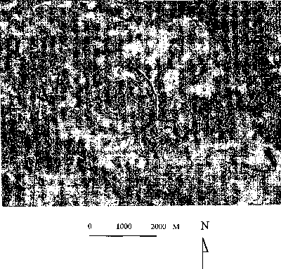
Figure 2:
- Buddhist altar
- Broken pottery
- Track along the inner side of the ancient earth wall
- Present land use (Agriculture Land)
- Ancient moat
7.Reference
- Praphattong. K., Histroocal Archaelogy. Department of Fine Arts. Bangkok, Thailand p.p. 87-94, 1986.
- Remote Sensing Center Resarch and Technology Development, Radar Imagery: Theory and Lecture Note, RSC Series No. 67. Food and and Agriculture Organization of the United Nation Rome, p.p. 19-25, 1993
- Natural Resources Canada, Radar Basics: Introduction to Synthetic Aperture Radar Remote Sensing. Technology Transfer, Training & Development Section, 76 pages, 1994.
- Radar SAT International, Introduction to Radar SAT and It's use in project planning and execution. Globe SAR Regional Workshop Bangkok, Thailand, November 28-December 2, 1994.
- Suppajanya, T., Study of ancient cities from aerial photograph. Chularong khorn University 1 sheet, 19…