| GISdevelopment.net ---> AARS ---> ACRS 1995 ---> Mapping from Space |
Dem Generation by Satellite
Imagery and its Accuracy
Tsuneaki
Shimoji
Geographical Survey Institute
Tsukuba- shi, Ibaraki-ken, Japan
Abstract Geographical Survey Institute
Tsukuba- shi, Ibaraki-ken, Japan
DEMS were generated through stereo-matching technology by using stereo satellite imagery of JERS-1 OPS and SPOT HRVdata. These data were evaluated by comparing them with existing DEMs derived from topographic maps. The accuracy was compared in the following two cases; (1) basically relying on satellite position and attitude data, (2) with many GCPs. The effect of pre-processing to original images was found effective for removing large errors caused by mismatching around mountains tops.
1. Introduction
Three dimensional measurement of satellite images can be done by stereo pair images of SPOT and JERS-1 through comparing them with existing DEMs several cases are compared in view of target area's topography and existence of image pre-processing and so on.
2. Test Sites
2.1Test data
We selected test data where there are few clouds in the area so that matching accuracy is not influenced, and where are equally distributed mountains, valleys and hills. Test data used for both satellite are listed in Table1 and 2.
| Left image | Right image | |
| Sensor | HRV-P | |
| wavelength | 0.51 µ m~0.73 µ m | |
| Path -row | 328-279 (Minobu) | |
| Date | 1992.11.12 | 1992.11.16 |
| Pointing Direction | R 17.2 Degrees | L 20.9 degrees |
| NadirLooking image | ForwardLooking image | |
| Sensor | OPS | |
| Scene name | Tokyo | Nikko |
| Path-Row | 65-241 | 65-239 |
| Date | 1993.3.9 | |
| Process level | L1 | |
2.2 Test Sites
The following test sites were selected: A and C areas are gentle slope with plain and hills, B and D areas are severely mixed with valleys and ridges where condition of accuracy test is comparatively hard. E area was added for evaluation in JERS-1 The sizes of test areas are about 15km. In length, and figures of test areas are rectangle DEM points for accuracy verification were 90000 points for each test site.
Contour lines of test site B and D are shown in Figure 1 and 2. Respectively the data used for each test site are shown in table 3. Average and Standard deviation of table 3 were calculated from DEM of Digital Cartographic Data derived from 1:25,000 topographic map.
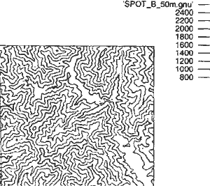
Figure 1: Contour Lines of test site B
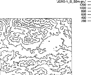
Figure 2: Contour Lines of test site D
| Satellite and Test Site | North West Corner | South East Corner | |||||
| Latitude | Longitude | Latitude | Longitude | Average | S.D | ||
| SPOT | A | N35° 34´05" | E138° 24´35" | N35° 22´50" | E138° 32´05" | 503.17 | 238.75 |
| B | N35° 21` 08" | E138° 04´41" | N35° 13´38" | E138° 15´ 56" | 1448.39 | 402.86 | |
| JERS-1 | C | N35° 40´00" | E139° 07´ 30" | N35° 32´30" | E139° 18´ 45" | 320.00 | 142.50 |
| D | N35° 40´45" | E138° 56´30" | N35° 33´30" | E139° 07´45" | 537.41 | 205.69 | |
| E | N35° 32´30" | E139° 03´45" | N35° 25´00" | E139° 15´00" | 804.49 | 301.00 | |
3. Test Method
3.1 Data for evaluation
DEM of Digital Cartographic Data is used for accuracy verification of the satellite DEM. The Digital Cartographic Data DEMs are derived from 1:25,000 scale Topographic Maps published by the Geographical Survey Institute through vector-raster conversion of the scanned contour lines and height interpolation . The DEM product is published by the GSI as "Numerical Map 50m Mesh" in floppy disks . The grid interval of this DEM is 2.25 seconds in longitude and 1.5 seconds in latitude, both of which correspond to about 50 meters on ground . Because these DEMs are used for verification accuracy of DEMs derived from stereo matching of satellite imagery , the DEMs from satellite are also interpolated according to the same according to the sane coordinate system as the existing DEM , namely grid interval of 2.25 seconds in longitude and 1.5 seconds in seconds in latitude.
For the comparison ,the difference between height value obtained from stereo matching and that of the "Numerical Map 50m Mesh" is calculated values are the mean of the absolute value , and root mean squares of the difference of the DEMs as well as relative by subtracting the mean of the difference .
3.2 SPOT
Eight points of GCPs were evenly obtained on the whole area . Result of the orientation of the images were within two pixels in RMS error in both pixel and line directions . Affin transformation is used for the geometric correction.
There were not any significant difference in the accuracy of DEM with or without pre-processing in both the test sites (A and B ) .Therefore the accuracy of the DEM was examined by the difference of topographic characteristics of the area only.
3.3 JERS -1
3.3.1 Matching method
Matching methods used are SSDA (Sequential Similarity Detection Algorithm ) and area correlation method . The first search was done for only sampled points in a fixed interval with rather large searching window size by SSDA . Then the second matching was carried out by more precise area correlation method.
Correlation window size was fixed to 9x9 on each method . it was decided by the following reason resolution of forward looking image is a little bit worse than nadir looking image because observation distance is longer . Therefore to make matching window size too large on different resolution images may cause mismatching . The Stabilest result in view of matching accuracy was obtained with window size of 9x9 from previous result accuracy verification in Tsukuba test site.
3.3.2 Adoption of GCP
Accuracy was compared when many ground control points (GCPs ) were used and when only one control points was used . In the former one , DEM was corrected assuming a trend surface of height error of position only at starting point in stereo image .this point is located within test d, the same point is used in other test sites c and d
3.3.3 filtering processing
high frequency component of images is enhanced so as to detect the peak of correlation in stereo matching . We employed un-sharp masking method for this enhancement .effectiveness of this filtering preprocessing is evaluated from DEM results.
4.Test results
test result from each test site of each satellite is listed in tabel4 and 5 . Contour lines of stereo matching is shown in Figure3 and 4 ,Figure 5 and 6 shows each contour lines of the difference between the dam by stereo matching and existing DEM of Digital Cartographic Data.
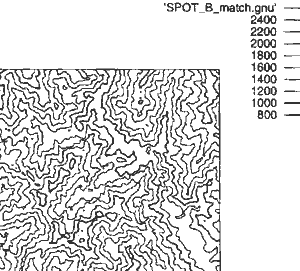
Figure 3: Contour Lines of Stereo Matching in test site B
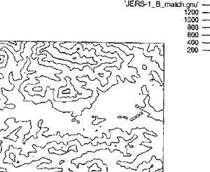
Figure 4: Contour Lines of Stereo Matching in test site D
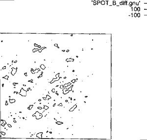
Figure 5: Contour Lines of errors in test site B
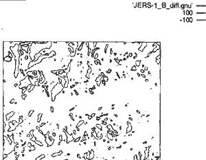
Figure 6: Contour Lines of errors in test site D
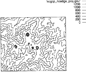
Figure 7: Contour Lines without Image filter in test site E
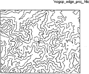
Figure 8: Contour Lines With Image Filter in test site E
| Area | Positive Maximum Error | Negative Maximum Error | Bias | Ave.of Absolute Difference(1) | R.M.SE.1) | Ave.of Absolute Difference(2) | R.M.SE.2) |
| A | 252.60 | -452.10 | 8.13 | 22.34 | 34.97 | 19.80 | 34.02 |
| B | 266.30 | -384.80 | -1.01 | 35.55 | 53.20 | 35.78 | 53.19 |
| Area and Case | Positive Maximum Error | Negative Maximum Error | Bias | Ave.of Absolute Difference(1) | R.M.SE.1 | Ave.of Absolute Difference(2) | R.M.SE.2) | |
| C | Case 1 | 228.80 | -233.00 | 8.14 | 45.55 | 58.93 | 44.17 | 58.37 |
| Case 2 | 233.80 | -243.00 | 8.34 | 45.74 | 59.13 | 44.27 | 58.54 | |
| Case 3 | 262.70 | -206.80 | 19.44 | 46.17 | 59.73 | 42.01 | 56.49 | |
| D | Case 1 | 232.10 | -291.90 | -25.54 | 58.43 | 74.86 | 55.51 | 70.43 |
| Case 2 | 236.70 | -323.00 | -25.34 | 57.83 | 74.48 | 54.89 | 70.19 | |
| Case 3 | 305.10 | -233.90 | 33.89 | 62.02 | 77.39 | 54.52 | 69.58 | |
Positive Maximum Error : Positive maximum Difference with Digital Cartographic Data
Negative Maximum Error : Negative Maximum Difference with Digital Cartographic Data
Ave.of Abosolute Differce1) : Ave of absolute Difference with Digital Cartographic Data R.M.SE.1 : Root Mean square Error with Digital Cartographic Data
Ave.of Abosolute Differce2) : Ave of absolute Difference after subtracting the Bias.
R.M.SE.1 : : Root Mean square Error after subtracting the Bias.
Case 1:with no GCP, without filter.
Case 2:with no GCP, with filter.
Case 3:with GCP, without filter.
5. Consideration
GCP
No difference of accuracy in bothcase1 and case 3 was found .according to a theory ,dam with higher accuracy should be obtained by using GCPs . But Accuracy was hardly improved because test site has sharp undulation where it is very difficult to get accurate height at GCPs . Artificial objects clearly seen on images is helpful when an operator gets GCPs .But many of artificial objections in mountains are located near a steep cliff ,which results in increase of errors to identify the position on a topographic map.
filtering Processing
There were not large differences of accuracy in case 1 and case 2 from the comparison of result .but it was found that filtering processing can remove large errors caused by mismatching , particularly in test site E where is the most hard undulation among all test sites. After this , I think so that verify accuracy of DEM by method as follows.
We plan to continue accuracy test of stereo matching using pre-processing which do not enhance the whole image but selectively enhance linear structures on using Laplacian-gaussian filters for pre-processing.
References
- Geographical survey institute, 1993. report of the study on topography Mesurement by Digital images (in Japanese)
- H.Masaharu,et.al.; three dimensional measurement by JERS-1 ops stereo data is prs commission IV SYMPOSIUM ,1994, JAN.
- M.Takagi,H.Shimanda ,et.al.; Handbook of image analysis (in Japanese),univ. of Tokyo press,1991,pp548-558