| GISdevelopment.net ---> AARS ---> ACRS 1995 ---> Mapping from Space |
Measurement of Topographic
variation by Hyogo-Nanbu Earthquake with JERS 1STAR Interferometry
Yuichi Maruyama, Hiroji Tsu
Earthquake Remote Sensing Data Analysis Center (ERSDAC)
Forefront Tower, Kachidoki 3-12-1, Chuo-ku, Tokyo, JAPAN
Tel. 03-3533-9380,fax. 03-3533-9383
1.
Introduction Earthquake Remote Sensing Data Analysis Center (ERSDAC)
Forefront Tower, Kachidoki 3-12-1, Chuo-ku, Tokyo, JAPAN
Tel. 03-3533-9380,fax. 03-3533-9383
The Hyogo-Nanbu Earthquake occurred on 17 January 1995 attacked the Kobe city and the Awaji island. More than 5,000 of human lives were lost under the collapsed houses and a fire.
The fault activity was observed on the several points in the area after the occurrence.
The fault displacements were measured in many places. The deformation of the topographic surface, however, was hardly measured on the surrounded area of the fault line.
The purpose of this study is to know the availability of the interferometric SAR for the deformation of topographic surface, by the earthquake with JERS-1 SAR data. Because, it can be very useful information for the study of active geological structure. In addition, it is also possible to apply for the natural disaster focusing such as landslide, volcanic hazards, etc.
For this purpose the area studied is selected in the northern part of Awaji island (Figure1), where the Nojima fault, one of the active faults had moved to rise sever hazar.
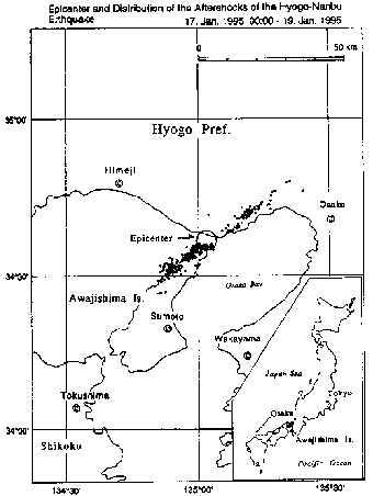
Figure 1: Location of Study Area
2.Method
2.1 Data Used
The data employed to carry out double difference interferogram analysis are shown as followed:
- JERS-1 SAR data
- acquired on 9 September 1992
- acquired on 6 February 1995
- DEM It is 50m interval mesh data, that is based on 1:25,000 topographical maps.
The process to generate the interferogram and double difference interferogram image is shown in Figure 2. At the first step, phase preserved SAR imageries were created with the data from the 1992 and the 1995 scene, the interfered in them to create initial
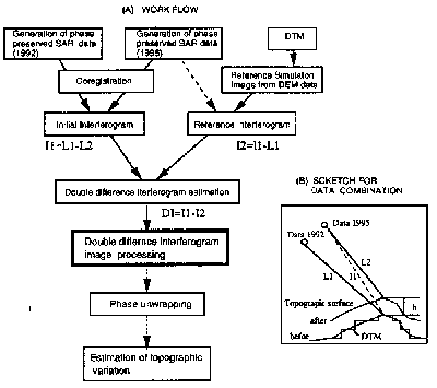
Figure 2: Flow and sketch for process of double difference interferogram image preparation
Interferogram. Then, reference interferogram was generated with the virtual phase and the 1992 scene data. The virtual phase was generated from the satellite position of 1995's scene to the DEM (Digital Elevation Model) surfaces.
The subtraction of these two interferogram could realize to obtain a double difference interferogram. The process and data matching are schematically shown in Figure 2(B).
2.3 Double Difference Interferogram Imagery
The estimated phase difference was divided into three levels to assign them different colors (Figure 3), and the imagery divided into two levels is prepared additionally (Figure 4 ). These two kinds of imageries are prepared for the following purposes. The figure 3 is to understand total amount of topographic variation. JERS-1 SAR represent the topographic variation of 11.75 cm by single rotation. This value corresponds to a half of wavelength of JERS-1 SAR. The figure 4 is prepared as convenient imagery for the interpretation of small scale topographic deformation.
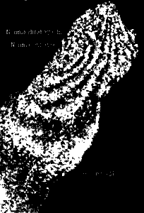
Figure 3: Double difference interferogram image (Divided into three levels)
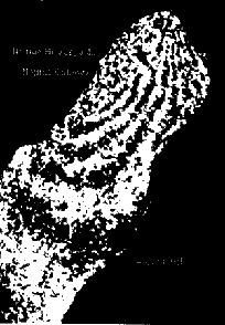
Figure 4: Double difference interferogram image
3.Interpretation of the Imageries
The double difference interferogram imagery was interpreted on the view point of geological study. The results are simply shown in Figure 5 and the following items are summarized.
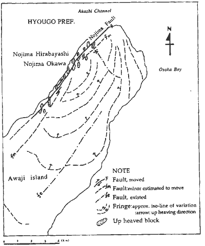
Figure 5: Geological interpretation of double difference interferogram image
- Total variation of the area
A rotation of colors indicates the amount of topographic variation by the earthquake. The color rotation, red green -blue -red in the double difference interferogram (Figure 3), repeats six times in this case which means that vertical is recognized in 70 cm approximately in the northern Awaji island after the earthquake. - Coinciding of the heavily displaced points and center of fringe
pattern
The villages of Nojima-Hirabayashi and Najima-Okhawa are locating on the central part of the fringes (circular/ oval pattern ). Some of the biggest vertical displacement on the fault scrap was observed in those villages , Nojima hirabayasi and Najima Okhawa. The displacement was approximately 1.8m as maximum ,however such big displacement was only at the limited part of the fault. - The fault and related deformation
Location of the fault can be interpreted in discontinuity of the color, and they are making a lineament. The pattern of fringes does not cross the Nojima fault but there distribute many block patterns in the fault zone. Those blocks could be generated by the fault activity, right lateral strike-slip.
Most of the blocks developed along the Nojima fault have an elongated shape with axis from North to South. It seems that ground surface was undulated by the right lateral strike-slip of the Nojima fault (Figure 4and 5). This undulated might be in centimeter order, because the color of this area repeats in red and green, lacking blue color in most part(see Figure3).
The result of image interpretation seems to be Consistent to general idea of structural geology. In many cases, strike -slip structure involves en echelon folds with them.
Those folds have axis that cross the shear zone with narrow angles to moving direction. The swelling blocks in the strike-slip zone of Nozima fault are in small scale, however the direction of their axis is harmonious to en echelon folds model. It is considered that the undulation in the fault zone could be involved by the fault activity. From these view points it can be concluded that double difference interferometry with JERS-1 SAR contain enough preciseness and useful for geological purposes in this area.
There, however ,are still some problems to be solved before generalization. The topographic variation has not proved yet by field survey in a vast area. Back scatter of SAR come from ground surface ,forest body by volume scatter and other artificial works. Seasonal charge of forest condition affect on the phase generation . Wave length of microwave should be considered with relation to the vegetation condition .Massonnet,et al., succeeded to get topographical variation by Landers earthquake in California. This study indicates that C-band of ERS-1 SAR Adapt to semi-arid zone where vegetation is sparse.
The mesh size and accuracy of the DEM data also have to be checked. JERS-1 is not designed for interferogram analysis, so data of satellite position is estimation.
Nevertheless, this technique is expected as a new accurate method to measure the topographical variation over the area in a short period.
ERSDAC/MITI is planning the next generation SAR program (SAR2), currently scheduled to launch early 2000s. As new SAR parameters, multi frequency, multi polarization and off-nadir angles are considered so far. Interferometry is also recognized as an important parameter for new SAR Mission.
Reference
- Boulter, C.A., 1989, Four Dimensional analysis of geological maps. Wiley Massonet, D., Rossel M., Carmona, C., Adragna, F.,Petzer,G., Ferigl,K., Rabaute,T.,1993,The displacement field of the landers earthquake mapped by radar interferometry.nature,vol.364
- Lin,A.,Imiya H.,Uda,S., misawa,T.,1995,Morphological characteristic of the Nojima earthquake fault. Japan Society of Engineering Geology 36-1,p39-50
- Haraguchi, T.,Okamura,M.,Tsuyuguchi,K.,1995,Report on the Nojima-Earthquake fault caused by the 1995 Hyougoken-Nandu Eatrhquake. Japan Society of Engineering Geology 36-1,p51-61