| GISdevelopment.net ---> AARS ---> ACRS 1995 ---> Mapping from Space |
Montoring Land Use/Land Cover
Changes in Phuket Island
S.Chutiratanaphan
Land Development department
A. Chanthanaroj
Land Development department
K Otsuka
Geographical survey institute
K . katusta
Geographical survey institute
Abstract
Land Development department
A. Chanthanaroj
Land Development department
K Otsuka
Geographical survey institute
K . katusta
Geographical survey institute
This paper outlines some major land use/land cover changes in Phuket Island, Southern Thailand. The rapid expansion of urban area has occurred both in town and along the seashore and abandoned tin mines have been changed to be golf course and luxurious resort. The changes in agricultural land are mainly the reduction of pararubber area and paddy field and the increasing of shrimp farm in the mangrove forest. All of these changes can be detected and identified by using SPOT and Landsat-TM data.
1. Introduction
The study was done in context of a combined project of the land Development Department of Thailand (DLP) and the Geographical Survey Institute of Japan (GSI),
finance was supported by The services and Technology Agency of Japan (STA). The purpose of this paper is to monitor land use/land cover changes in Phuket Island, located in the Andaman Sea, Southern Thailand. It is the biggest island and the one of the most popular tourism land in the country. Its total area is about 539 sq.km.
During the last decade, the situation of land utilization need in this study area has been in critical stage. Due to the rapid growth of economic and population, the need of land for cultivation, human resettlement, tourism industrial and shrimp farming has drastically increased. These factors have caused a great deal of natural resource explosion without proper planning. For instance, a large of luxuriant of mangrove forest
Has been destroyed for shrimp farming, upland forest has been depleted for agricultural areas particular on the slope land and abandoned tin mines were changed to luxurious resort and some cultivation area. These changes are not only the natural resources degradation but also the deterioration of the environment, The use of remote sensing technique has proven to be a most valuable tool in monitoring land use/land cover changes in this study.
2. The Study Area
The study area is Phuket island, which located in he Andaman Sea, Southern Thailand. It lies approximately between 7° 28´ - 8° 13´N. latitudes and 98° 15´- 98° 28´E longitudes. The total area is about 539 sq.km., the population is about 162,694. The landscape of the study area is characterized by slope complex, rolling and undulating, flat to nearly flat, mangrove back swamp forest and beach and beach ridge. The slope complex area (36.05%), rolling and undulating area(40.37)%) are mainly covered by evergreen rain forest and pararubber plantation. Flat and nearly flat area (14.45%) is widely used for pararubber plantation and paddy field. The others are 9.13% of total area. Climate is defined as the tropical monsoon, mean annual rainfall about 2,227.6 mm. And the heaviest rainfall is in September and October.
3. Objective
The main purpose is to monitor land use/land cover changes using remote sensing technology.
4. Materials and Methodology
Materials :
- Topographic maps are in the scale 1:50,000 covering the study area.
- Landscape5-TM image of path 130-row 54 (3R,4G,2B), acquired on February 15,
- SPOT image of path 26-row 334 (2R,3G1B), acquired on December 13, 1988
- Collecting data.
- To specify changed areas from 1988 to 1993 for ground truth by using satellite data.
- Ground truth and collecting the local references data.
- Discussion and report.
The results of the study on the monitoring land use/ land cover changes in Phuket area by remote sensing technology using SPOT , Landsat-TM data and ground truth survey. The data are categorized in to 9 groups as follow, abandoned tin mines have changed to golf courses and built-up area, mangrove forest has changed to shrimp farm, rubber plantation has changed to built-up area, paddy fields has changed to built-up area and grass land and forest have changed to rubber plantation.
6. Conclusions
The main factors of land use/land cover changes in Phuket island are the rapidly increasing population, expansion of human community (including resorts and golf courses) and encroachment of mangrove forest to be shrimp farming. The remote sensing technique is appropriate tool to monitor land use/land cover changes in Phuket area. These results can establish trend in land cover changes and utilization as guideline for natural resource and environment management in Phuket island.
7.Acknowledgment
We'd like to express our great thanks to the staff of Science and technology Agency of Japan for their suggestions and helps as the financial support for this project.
8. References
- B.Klankamsorn. 1992. Monitoring Mangrove forest covered Shrimp farms in Thailand.
- Paper presented at ISY regional Seminar on Tropical Eco-System. 1992.
- S.Chareonpong, et al., Soil Survey in Changwat Phuket Report, Soil Survey and Classification
- Division, Land Development Department, Bangkok, 226p, 1984.
- Y.yasuaka, T. Miyazaki and Y.Iikura(1990): Detection of Vegetation Changes from Remotely Sensed Images Using Spectral Signature Similarly. Poc. Of intro. Geosciences and Remote Sensing Symposium'90.
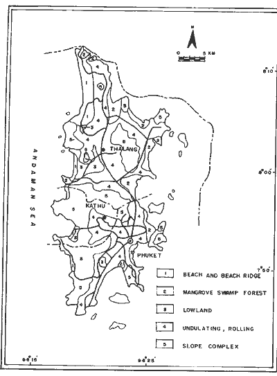
Figure 1: The Study Area