| GISdevelopment.net ---> AARS ---> ACRS 1995 ---> Land Degradation |
A Knowledge-Based Approach
for Land Evaluation using Rs And Gis Techniques
D. Amarsaikhan,
M.Ganzorig
Informatics & RS Centre, Mongolian Academy of Sciences
av.Enkhtaivan-54B, Ulaanbaatar-51, Mongolia
Abstract Informatics & RS Centre, Mongolian Academy of Sciences
av.Enkhtaivan-54B, Ulaanbaatar-51, Mongolia
Application of a knowledge-based approach in the earth sciences is of great interest nowadays. The main aim of the research was to build a prototype geo expert system (GES) which can be used in decision making on the basis of the knowledge-base gathered from RS and GIS experts within GIS environment. For this purpose, land evaluation for wheat suitability was performed. In the selected area, the basic object consists of the surface elements characterized by attributes some of which are unknown. They were determined by the use of RS and GIS techniques cooperating with the experts from this field.
1. Introduction
Land evaluation is a method applied to the assessment of land suitability for a specific use. Land evaluation is itself knowledge-based and requires an extensive knowledge and different conditions to be fulfilled. This can be done automatically by the use ALES, LECS and GIS systems. At present, the use of knowledge- !'"' based (expert) systems in the geo-related sciences is not anew the phenomenon. Different types of these systems have been and are )., being developed depending upon the structure of knowledge representation. Knowledge can be represented in the forms of semantic networks, object-attribute-value (O-A-V) triplets, frames, decision trees, production rules, etc. The characteristics of these techniques are discussed by Amarsaikhan (1994) .At present, in the field of geoinformatics the widely used structures of knowledge representation are the frame-based and rule-based types. Our aim in this study is to use a knowledge engineering approach for land suitability analysis. For this purpose, land evaluation for wheat suitability was performed. The crop requirements were conditionally defined by the use of knowledge acquisition techniques.
2. The Study Area
As a test site was selected an area situated in the central part of the Orkhon-Selenge basin, Mongolia. The area is included into the mountain-forest-steppe zone and its landscape is divided into 5 zones within which the agricultural land use is distributed (Ganzorig et al. 1995) .The area has different types of relief and soil and vegetation cover changes according to the relief morphology. The relief and weather conditions in this area are very suitable for agriculture. The selected area is located on the south-facing low slope and has zonal dark chestnut soil. The main cultivated plants are wheat and luzern.
3. Data Collection and Knowledge Acquisition
For the land evaluation the following materials were available:
- SPOT XS image of May 1988;
- Soil map, scale 1:50, 000;
- Topographic map, 1:50, 000;
- ground truth data.
4. Research Problems and Methods
4.1. In the selected area the basic object (landunit (LU) ) consists of surface elements characterized by attributes: LU(#, name, depth, ph, stony, rockiness, erosion class, slope, texture, moisture).
So there is a model for land evaluation and we conditionally assumed that some important values (slope and moisture) are unknown. They will be determined using RS and GIS techniques cooperating with experts from this field. To reach the goal in the study, the following basic problems should be considered:
- How to select appropriate algorithms from a subroutine library of RS/GIS software (ILWIS) ?
- How to choose parameters of the selected algorithms for optimal land evaluation using RS and GIS data?
- How much does the selection 9f procedures and parameters depend on context ?
Slope will be calculated using contour map of the area. Moisture will be determined by statistical pattern recognition. In this case, by maximum likelihood decision rule using prior probability which will be defined from the ancillary data by ' experts in geo science whose knowledge is important for the best C.'~II training sample selection. In the Hypotheses domain 4 hypotheses will be proposed . (Sl,S2,S3,S4 which are highly suitable, marginally suitable, moderately suitable and not suitable, respectively)
5. System Design and Implementation
Based on the concepts of a KBS and a GIS a prototype GES has been developed. The program was written in C language and linked to the LWIS GIS software. The structure of the system is shown in Figure1. GIS contains a specific view of a certain part of the real world ! which means it should contain a database and the analysis tools to I be used in a given problem solution. The development of the I database was done by digitizing soil and topographic maps and into which satellite image was registered.
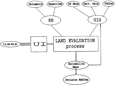
Fig l General Structure of the GES
In the image haze correction and enhancement techniques were applied. For the development of the GES simple frames have been used for the questions' display and the knowledge base was represented using "IF conditions THEN conclusion" statements. It is possible to manipulate all necessary procedures of the GIS from : within the GES. All attribute values have been conditionally collected. Knowledge on the study area has been first represented : as a O-A-V triplet and then normalized using an inference tree. : From the normalized tree the rules to be used for the hypotheses evaluation were hierarchically extracted. Slope and moisture r information were defined by the use of the above mentioned techniques (see section 4.2) and the related attribute values were ~ exported to the O-A-V triplet before the normalization. During the .slope and moisture determination in RS and GIS procedures the appropriate parameters have been automatically suggested according, to the context of the area.
For the hypotheses evaluation forward chaining principle has been used and the procedure is described as follows:
The output is the map indicating the land suitability for wheat planting ( Figure 2)
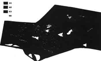
Fig 2 Suitability Map for Wheat
6. Conclusions
The research was carried out to test the role an expert system approach in geo related processing in case of missing some facts. As seen from the analysis , knowledge of the accuracy of the information required for the decision making is very important. The developed system is an early prototype and has many limitations. To Also forward chaining search has demonstrated its weakness. It stops when missing some facts. In this case, it is better to use backward chaining in the matching of the rules and forward j ; chaining in data processing.
References.
- Amarsaikhan, D., Gorte, B., 1992, Knowledge-based Approach to Update Land use Layer of an Operational GIS, Proceedings of ACRS, I Ulaanbaatar, Mongolia.
- Amarsaikhan, D., 1994, Fundamentals of KBS and Artificial Intelligence Approach in RS and GIS, Journal Informatics, 8,2-93,Ulaanbaatar, Mongolia.
- Ganzorig, M., Adyasuren, Ts., 1995, Application of RS and GIS for Ecosystem Monitoring and Management, Paper presented at the International Seminar on Space Informatics, Ulaanbaatar, Mongolia.'
- Jun Chen, Peng Gong, Newkirk, R.T., and Davidson, G., 1991, A Knowledge Based GIS for Zoning, Proceedings of European Conference. on GIS.
- Miller, D., and Morris, J., 1992, An ES and GIS Approach to Predicting Changes in the Upland Vegetation of Scotland, European Conference on GIS, 11-19.
- Matsuyama , T., 1987, Knowledge-based Aerial Image Understanding Systems and Expert Systems for Image Processing. I.E.E.E. Transactions on Geoscience and Remote Sensing, 25, 317-328.