| GISdevelopment.net ---> AARS ---> ACRS 1995 ---> Land Degradation |
Diagnosis of Land Degradation
In the Semi-Arid Area of Asia and Pacific Region 10-/ Using Remote Sensing
Data -JIRCAS's Case Study-
Satoshi Uchida
Japan International Research Center for Agricultural Sciences (JIRCAS)
1-2 Ohwashi, Tsukuba, Ibaraki 305, Japan
presently Visiting Scientist of International Crops Research Institute for the Semi-Arid Tropics (ICRISAT)
Patancheru 502324, Andhra Pradesh. India
Abstract Japan International Research Center for Agricultural Sciences (JIRCAS)
1-2 Ohwashi, Tsukuba, Ibaraki 305, Japan
presently Visiting Scientist of International Crops Research Institute for the Semi-Arid Tropics (ICRISAT)
Patancheru 502324, Andhra Pradesh. India
Land degradation which restricts the reproductivity of biomass appears at various areas in the world. In the semi-arid area the multiple types of land degradation happen to integrate to accelerate desertification. JIRCAS has implemented several research projects in collaboration with overseas institutes for the purpose of seeking sustainable land use system in the semi-arid area. This article describes the activities of case studies which have been adopted remote sensing data. This treats the physiographically specific topics in terms of land degradation appeared in the objective countries such as soil erosion in Pakistan and desertification of rangeland in Australia. The methodology to assess land degradation using remote sensing data should consist of the different stages of process, which are to identify the objective phenomenon from the image, to develop an appropriate indicator, to produce dataset and to evaluate the availability of land resources. This article also mentions about the Interrelation between these stages,
1.Introduction
In recent years global environment issues have been argued in focus with quantitative measmement of objective parameters which may vary temporally and spatially .Once an estimated value is quantified and published, analyst who often utilize the secondary data may produce Wild life result. This problem is probable to occur in the estimation of global value accumulated with local data taken by nonstandardized methodology. Researchers expect to establish the methodology to assess global environment using remote sensing data as a quantitative information source. At this point it is necessary to discriminate the phenomenon whether it would be suitable as a target of remote sensing data analysis or not.
Land degradation, which is one of representative deteriorating factor of the environment, could be observed in the world wide. Land is a base to reproduce vegetation and its degradation corresponds to the restriction of vegetative activity by the change of growth conditions. Vegetative activity correlate with both agricultural productivity and environmental conservation. Land degradation tends to be an irreversible process, therefore in order to establish sustainable land use system it is important to make attempts to discover the area prone to land degradation as well as to monitor the progress of degradation .
Some typical phenomena of land degradation appear in the semi-arid area and they often cause the expansion of desert area. Desertification may be evaluated through vegetative activity on the surface but the difficulty comes from its temporal variation. Ground conditions which influence the growth of vegetation must be more suitable indicators of desertification. Representatively geomorphologic, chemical and physical degradation of soil can be identified to evaluate the state of desertification.
JIRCAS (Japan International Research Center for Agricultural Sciences) is one of the research i; institutes belonging to the Ministry of Agriculture, Forestry and Fisheries and has implemented collaborative research with overseas institutes. JIR.CAS has introduced remote sensing and GIS ~ techniques for the re some management of semi-arid areas. This article describes the outline of recent JIRCAS's activity adopting remote sensing data for the specific topics of semi-arid area. The author will try to explain the scheme of research projects in view of standardizing the methodology to assess environmental conditions.
2.Delineation of Land Degradation Using Remote Sensing Data
The quantification of spatial behavior at the specific moment is an initial step to monitor the progress of land degradation. The capability of wide spatial coverage of remote sensing data is its advantageous feature. On the contrary the limitation of spectral variety and spatial resolution of remote sensing data often makes it difficult to discriminate the different appearance of land degradation. It is needless to say that remote sensing data cannot apply to analyze any types of land degradation.
In the previous studies applications of remote sensing data to land degradation have been performed to delineate the state of soil erosion, soil salinization, water logging, foliage deterioration, etc. The experimental site of these examples spread over various parts of the world of which considerable percentages have treated cases in the semi-arid climatic conditions. The reason of this selection is supposed that the semi-arid area would be fragile against the environmental change in terms of its vegetative activity and land could be degraded in association with vegetation coverage over the land.
There are two types of soil erosion, one is wind erosion and the other is water erosion. Both of erosion types affect the geomorphologic feature of land as well as distribution of top soil. Remote sensing data can detect directly the geomorphologic feature if spatial resolution is small enough to discriminate the pattern of eroded topography. Another method to evaluate the strength of erodibility which is a kind of indirect way, adopts an empirical parameter in correspondent with controlling factor by coverage of ground surface. Many examples have published to estimate C factor of USLE equation from vegetation index or other indices calculated from multispectral data of remote sensing. The appearance of saline soil or water logging area could be interpreted from the remote sensing imagery .The problem of reproductivity of the same result by manual interpretation may become critical if quantitative analysis is necessary. The extraction of salt affected or water logging area requires the intonation not only spectral characteristics but its geographical location in association with the topography of objective area. It is significant to introduce GIS for the purpose of extracting and monitoring salt affected or water logging area in the digital based remote sensing data analysis.
The growth of vegetation is influenced by the factors of land management besides climatic and " c' nutrient features of land. In case of agricultural land vegetation coverage varies with the cropping pattern therefore land degradation cannot be evaluated by only the change of vegetation. Apart from agricultural land and manmade land use, vegetation coverage may indicate the magnitude of land degradation. The rangeland in the semi-arid area is a good example to show the tendency of deteriorating, vegetation associated with land degradation. The methodology to monitor vegetation coverage using remote sensing data has been developed and examined its applicability by number of researchers for these decades.
Table 1 summarizes the use of remote sensing data to delineate land degradation in the semi-arid area. This table suggest~ that remote sensing data would be evaluated as a useful information to monitor land degradation although the methodology of quantitative measurement has not been established. Studies on standardization of method of analysis are required primarily at this stage.
| Degradation Type | DElineated Feature | Methodology | Remark |
| Water Erosion | Gully (Topography) Coverage (Control Ractor) | Interpretation, Texture Indices by multiple bands | Empirical factors would be included |
| Wind Erosion | Sand move | Interpretion, Band calclulation | Difficult to find position |
| Soil Salinization | Soil color change | Interpretation, Band calculation | difficult to be quantified |
| Foliage Deterioration | Density (Biomass) Species change | Vegatation index etc. Classification | Seasonal change should be considered |
3.Case Studies Implemented by JIRCAS
JIRCAS has implemented collaborative research projects with overseas institutes since 25 years .ago when the name of institute was Tropical Agricultural Research Center at the time. There are a number of on-going projects of which the target site is located in the semi-arid area and remote sensing ~ technology is employed. Table 2 shows a list of projects in which the author has taken part for recent years. Every projects treat the problem in the semi-arid area and employ the remote sensing data as information sources to analyze regional characteristics. Summary of each project will be described in the .following to the table.
| Project Theme | Country | Collaborative Institute | Period |
| Analysis of soil erosion in rainfed agricultural land | Pakistan | National agricultural Research centre | 1990- |
| Environmental changes associated with land use conversion in the semi-arid tropics | India | ICRISAT | 1993- |
| Production of desertification dataset of rangeland | australia | Centre for Arid Zone Research, CSIRO | 1994- |
(1) Analysis of soil erosion
The objective of this study is to delineate the topographic patterns appeared in the eroded area , using remote sensing data and to analyze the relation between erodibility and ground surface conditions. .Experimental site is the Potwar plateau located in the northern part of Punjab province in Pakistan, where .agricultural land is generally rainfed. In this area water erosion is a representative land degradation : phenomenon due to the existence of erosible soil and high rainfall intensity in the rainy season. Land I management which may affect the coverage of ground surface is another significant factor to extend the disaster prone area.
The procedure of analysis adopted in this study consists of two steps. One is to estimate erodibility of land by digital image processing of SPOT panchromatic mode data. The other is to examine the relation between erodibility and ground surface conditions estimated from multi-spectral Information of LANDSAT-TM data.
Figure 1 shows the distribution of calculated erodibility from SPOT data in the severely and lesser area which are manua11y interpreted from imagery .The method of estimating erodibility is that first the standard deviation of digital number within 3 x 3 window for high pass filtered image data is ' calculated and then 5 x 5 rank order filter is applied to represent the spatially extended feature. This result denotes that the method employed here could estimate the erodibility appeared in topographic eature by digital processing of remote sensing data only the improvement of method would be necessary .The discussions about spatial feature of experimental site have been described in the Proc. 15th ACRS last year (Uchida et al.(1994).

Fig. 1 Erodibility estimation by SPOT data
Figure 2 to 4 show the relation between erodibility estimated by the method used in Figure 1 and .ground surface characteristics, where dot represents averaged value for each unsuper\lised classification . From these fIg ueres Coverage Index calculated from band 2 and band 3 data of LANDSA T -TM, c'"' which is a modification ofPD54 developed by Pickup et al.(1993), has stronger colTelation compared with Nonnalized Vegetation Index. Another interesting feature is that seasonal difference between Rabi cropping season, represented by LANDSAT-1M taken on 9th February 1992, and hot dry season, represented by SPOT taken on 2nd April 1990, has a strong colTelation with erodibility at naturally vegetated area excluding agricultural land. Although analysis has not been finished due to the limitation of available data and :field survey, these results provide the direction of mapping and land management for the risk of soil erosion with spatial context.
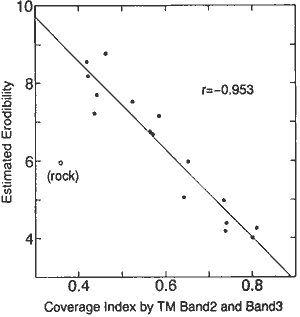
Fig. 2 Relation between coverage and erodibility

Fig.3 Relation between NDVI and erodibility
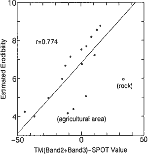
Fig.4 Relation between seasonal change and erodibility
(2) Environmental changes
This study has substantially started in this year and the author has stayed at ICRISA T since March 1995. ICRISAT is specialized its research activity to increase and stabilize the production of major six crops, which are sorghum, pearl millet, :finger millet, pegeonpea, chickpea, groundnut in the semi-arid tropics. The main objective of this study is to evaluate the effect of land use conversion on physical, chemical and biological processes occuning in the production systems in the semi-arid tropics. In this study Indian remote sensing satellite (IRS) data would be employed as a major data source for depicting the ground surface conditions.
ICRISAT is located at the boundary of two major orders of soil appeared in the semi-arid part of r India, which are Vertisol (black soil) and Alfisol (red soil). The fertility and capacity of water retention of these soils show different characteristics and the cropping patterns are generally different in association with these factors. These soils could be discriminated by manual inteIpretation of IRS imagery especially taken in hot and dry season. On the other hand it seems difficult to classify the cropping pattern I accurately because a variety types of inter-cropping is commonly observed in this area.
Many Indian scientists have conducted the works to produce maps relating to land degradation using remote ensing data. This study aims at the development of the method to analyze land degradation process using remote sensing data in collaboration with scientists in the field of crop and soil sciences. The sustainability of land would be examined in association with the probability of occurrence of droughts, floods, etc. in the production systems. Project activity would be strengthened after equipment and research associate are settled at ICRISA T .
(3) Production of desertification dataset
This study is a part of one of research themes in the Global Research Network Systems (GRNS) funded by Science and Technology Agency (ST A) of Japan. The title of research theme is 'Research on the production of fundamental dataset for the studies on earth science technology', which started in 1993. This theme consists of five working groups, which are hydrology, vegetation, desertification, ocean and base maps. The objective of the theme is to produce a standardized dataset applicable to environmental problems appeared on the earth.
Desertification dataset working group determinate to implement the research in collaboration with Center for Arid Zone Research, CSIRO in Australia. This institute has a long term experience on the management of rangeland, where cattle is extensively grazed, using remote sensing data. The representative land degradation of experimentaJ site ofthis study is the deterioration of foliage induced by grazing and soil erosion. The rate of defoliation could have a positive correlation with the density of cattle. Grazing pattern of cattle at this area, where surrounding fence of each paddock control the mo1ng range of animals, has been observed to show a function of distance from watet. supply point ( e.g." Pickup and Chewings( 1994) ). Soil erosion is shallow but influential to vegetative activity because soil I' layer which provide the growing conditions of vegetation is generally thin at this area.
Table 3 shows the contents of desertification dataset which JIRCAS plans to produce. There , are two types of data specification in terms of spatial resolution, one is low spatial resolution data to indicate the general physical conditions of the area and the other is higher spatial resolution data to indicate swface conditions. Desert Class may indicate generally the extent of desertification. In the arid and semi-arid area annual Normalized Vegetation Index (NDVI) of agricultural land would show the higher value than that of natural vegetaion area provided soil characteristics for vegetaion activity is similar .In order to evaluate the status ofvegemtion change year by yaer, remote sensing dam taken at the moment of driest season would be selected. Sample dataset would cover the experimental site of CSIRO near Alice Springs in the central part of Australia.
| Data Name | Methods | Spatial Resolution | Frequency |
| Desert Class | Aridity Index (P/PET) vs. Annual NDVI Soil Factor (physical characteristics) | 30"*30* | once |
| Toporaphy | Elevation, slope, Variance | 3"*3 | once |
| Grazing Intensity | Distance from Water Point | 3"*3 | once |
| Soil Stability Index | Soil Classification from Remote Sesing Data | 3"*3 | once |
| Coverage Index | Modified from PD54 (Pickup et al. (1993) | 3"*3 | annual (driest season) |
| Vegetation Change | Rate of Change of Vegetation Index | 3"*3 | annual (driest season) |
4.Assessment of Land Degradation for Sustainable Land Use Systems
The ultimate objective of assessment of land degradation is to establish sustainable land use systems. The definition of sustainability is controversial problem because it is difficult to define the spatial and temporal ranges to be considered. From this situation the reliable information of ground surface conditions should be collected systematically using remote sensing data. This information becomes the base to discuss the sustainability of land use systems.
The methodology to assess land degradation using remote sensing data can be divided into several stages in general. First is a stage to identify the objective phenomenon from the image. If the phenomenon can be discriminated by interpretation, there is a possibility to develop an appropriate indicator by calculation of digital data. Next stage should be a process of standardization of method to calculate indicators as well as examination of its reliability .Dataset production is another important stage to recognize the regional characteristics of land degradation in comparison with other areas. The last stage is to evaluate the availability of land resources in other. word the tolerance against environmental changes quantitatively .
Case studies introduced in the previous chapter have shown typical land degradation studies on selected experimental site. In some cases the methods to delineate the state of surface conditions are commonly adopted. For example a modified form of coverage index developed by CSIRO for monitoring the effect of grazing on vegetation coverage of rangeland has presented as an effective indicator to estimate erodibility of land in case of Pakistan. It seems necessary to examine the : applicability of indicators, which have been developed by a number of researchers, to the various types of - land degradation although most of them have not been analytically explained.
5.Conclusions
Land degradation is of significant environmental problem which could be observed at many areas in the world. Due to its variety of appearance, however, quantitatively reliable data about the extension J of land degradation in regional scheme has not yet been obtained. Remote sensing data has been expected to provide quantitative information about land degradation, on the other hand it has limitation to measure the detailed characteristics of the ground surface. At this it is proposed that land degradation should be categorized into the groups of which their physiographical features could be delineated by remote sensing data. Standardization of method to obtain the appropriate indicators is significant process to discuss and compare the regional characteristics of land degradation with other areas. Although the case studies described in this article are examples to have initiated from separate background, their direction of research should point at the establishment of methodology for common use.
Acknowledgment
The author is grateful to the counterparts of collaborative research institutes, Dr.Shahid Ahrnad, "'i.", Dr.Rakhshan Roohi and their staffs at Water Resources Research Institute of National Agricultural Research , Centre in Pakistan, Dr.K.K.Lee, Dr.S.M. Vinnani and relevant staffs of Division of Soil&Agroclimatology and Agronomy at ICRISAT, and Dr. GeoffPickup and his staff at Centre for Arid Zone Research ofCSIRO, for their continuous cooperation to each project activity.
References
- Pickup,G., V.H.Chewings and D,J.Nelson (1993): Estimating changes in vegetation cover over time in arid rangelands using Landsat MSS data. Remote Sens. Environ., 43, 243-263.
- Pickup,G. and V.H.Chewings (1994): A grazing gradient approach to land degradation assessment in arid areas from remotely-sensed data, Int. J. Remote Sensing, 15,597-617.
- Uchida,S., R.Roohi and S.Ahrnad (1994): Land degradation analysis of rainfed agricultural area in Pakistan using remote sensing data. Proc. 15th Asian Conf. Remore Sens., I, C-4, 1-5.