| GISdevelopment.net ---> AARS ---> ACRS 1995 ---> Global/Regional Change Study |
On the characteristics of the
1993/1994 Geostationary Meteorological Satellite high cloud amount
Ae-Sook Sub, Kyung-1a Ha*,
Sung-Euii Moon* and Seung-Hee Sohn
Remote Sensing Lab., Meteorological Research Institute, Seoul, Korea
Dept. of Atmospheric Sciences, Pusan National University, Pusan,
Korea
Abstract Remote Sensing Lab., Meteorological Research Institute, Seoul, Korea
Dept. of Atmospheric Sciences, Pusan National University, Pusan,
Korea
The characteristics of the GMS high cloud amount have been investigated for summer monsoon period of 1993/1994, the contrasting years in view of the summer monsoon precipitation. In order to investigate the monsoon features over the eastern Asian monsoon region, the cloudiness ( using derived by the geo stationary meteorological satellite), the condition of underlying surface including sea-surface temperature, and the summer rainfall are analyzed and some comparisons with 1993 and 1994 are also made and the characteristic differences are discussed.
An analysis of the 2-degree latitude-Iongitude gridded 5-day mean high cloud amount data shows the detailed movement and persistence of the convective activities. In order to describe the spatial and time structure of the intraseasonal oscillation for the movement and evolution of the monsoon cloud, the extended empirical orthogonal function analysis with the twenty-day window size is used for the each year .Also, in order to find out the periodicity of the equatorial convective cluster , Fourier harmonic analysis is applied to the each year .
The most prevailing intraseasonal oscillations of high cloud amount are 61day mode and 15 day mode in the equatorial and the subtropical oceans. However it was found that the most.. prevailing modes over the equatorial western Pacific and Indian ocean were different for each year , hence raising the possibility that the contrasting monsoon precipitation may be more fundamentally related to the interaction of intraseasonal oscillations and seasonal variation of convective activities over the lower latitude ocean.
1. Introduction
During the 1993/1994 summer over east Asia, we suffered from the contrasting climatic characteristics of precipitation such as a prolonged intense changma rainfall in 1993 and a weak changma with hot temperature in 1994. This paper, this contrasting characteristics will be analyzed from connection to the monsoonal structure of high cloud amount over east Asia and the equatorial ocean.
The intensity and duration of east Asia monsoon precipitation were thought to be connected with the onset and retreat dates of monsoon convective band, and its variabilities were characterized by sea surface temperature (SST) anomaly, the amount of snow mass over Eurasia, the equatorial flow of tropospheric low level, the process of flux convergence of moisture and the dynamic process of upper atmosphere. 'Specially, it has been well recognized by recent observational and theoretical studies that the summer precipitation over east Asia is largely affected by the SST and convective activity in the tropical Pacific (Nitta, 1987: Shen and Lau,1995). This relationship between the tropical western Pacific and the summer climate over east Asia has been clarified by the interaction of annual and intraseasonal variation of convective activity in the tropical region(Li and Wang, 1994). In the key studies of this nature, the 30-60 day oscillation was analyzed by many studies(Madden and Julian, 1971; Lau and Chan, 1986), the quasi-biweekly oscillation has been recognized (Krishnamurti and Bhalme, 1976).
In a more recent study, Tanaka(1994) have used the high cloud amount derived by the ..geostationary meteorological satellite(GMS) to analyze the summer monsoonal convection over west Asia. Maruyama et al (1986) showed also that the GMS high cloud amount can be used to estimate the rainfall in the tropical Pacific. Nitta(1987 ) and Tanaka(l99i, 1994) analyzed this data set and investigated the onset and retreat dates, and seasonal cycle in the summer monsoon clouds and its interaction with the intraseasonal oscillation. These results let it confirm that GMS high cloud amount is useful to analyze the summer monsoon activity .
In the present study, the extended empirical orthogonal function is used to obtain the evolutional structure of the principal spatial function of high cloud amount. And the intraseasonal oscillation is analyzed by the Fourier harmonic analysis, and its anomalous oscillation is established by means of the comparison of 1993 and 1994.
2 Data
The major data used in the present study is the five-day mean 2-degree latitude-Iongitude grid data of the GMS high cloud amount produced by the Japan meteorological satellite center . The data is constructed by time series from 1 April to 2 October in 1993 and 1994 respectively. The GMS high cloud amount is expressed as non negative integer below 10 and defined as the clouds having a cloud top temperature below the 400 hp a level climatological temperature based on observation (for example, Tanaka(1992) defined the summer monsoon cloud by the regions with more than 3 of the mean high cloud amount). This data is useful to estimate the precipitation for the reason of no missing data over land and ocean.
3. The characteristics of the 1993/1994 east Asian high cloud amount
Time-Iongitude sections of latitudinally averaged high cloud amounts for 32-38N and 6-12N are presented by Figure 1 and Figure 2, respectively. In case of 1993, the convective activity is situated strongly during summer monsoon period (June- July) over east Asia. Specially, one cloud branch moves to the northward toward Korea and Japan, while the inter tropical convergence zone(ITCZ) in the Northern Hemisphere appears lastingly in 5N-10N and extends northwestward in summer monsoon. However , during June and July in 1994, the northward branch is not appeared and the large cloud amount is accumulated at 15N-20N and the convective activity around Korea becomes noticeable in August.
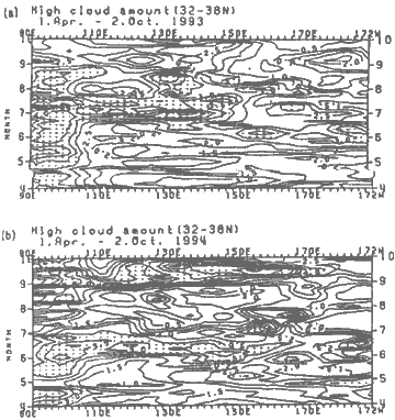
Figure 1. Time-longitude section of latitudinally (32-38N) averaged high cloud amount (a) 1993 and (b)1994 The dotted regions indicate the area larger than 3.0 of high cloud amount fraction.
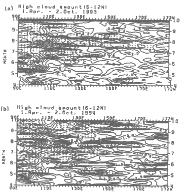
Figure.2 Same as in Figure except for 6-12N.
Specially, characteristics over eastward of 120E is situated contrastly. The convective activity moves eastward in time for May- June in 1993. That is the horizontally extended convective cloud band is appeared from July to August. In 1994, this development of convective activity is separated by two band with relatively small cloud area along northward movement and the strong convective cloud from 130E to 150E is lasted for July at lower latitude.
Namely, in case of 1993, the strong activity at the lower latitude is appeared for whole changma period. Whereas in 1994, for July the convective activity exists slightly around Korea and Japan, and It IS distinctly lasted at the lower latitude.
3.1 Extended empirical orthogonal function of high cloud amount
In order to investigate characteristics of time evolution of the principal spatial structure, extended empirical orthogonal function( EEOF) analysis with the 20-day window size and 10-day window size is applied to each year .The window size is decided by judgement that the ! 20-day can include the synoptic scale motion and then mean structure in 20 day explains the cquasi-stationary character. Now we can convert the original time-spatial function of high cloud amount to new time-spatial function reconstructed by which n is the number of windows. Then, can be expressed by the sum of the products of the time variation function, Wit and the space variation functions, as following formula. Then, is consisted of time function by spatial function.
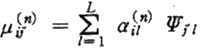
Where, ail is the window averaged space structure with the weight being the eigenfunction is common time structure of windows, and can be determined as the eigenfunction of covarience matrix of .Eigenvector represented by common time structure for the each window represents the time variation within the window size.
The first principle mode (Figure 3) explains the most of variability over 11% of mean total variances for 1993 and 1994. This EEOF mode exhibits relatively stationary phase, while second, third and fourth mode represent wave motion as shown by Figure 3 Figure 4 and 5 represent the time evolution of the spatial structure corresponding to the first principal mode in 1993 and 1994, repectively. The period indicated in figure is from 31 May to 8 August including; Changma season. We can perceive that the cloud band around 20N moves northward toward Korea and Japan during 20 June -19 July. Whereas, in 1994 it is noticed that the cloud band near 20N exists continuously without moving northward.
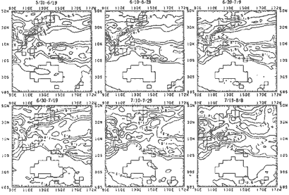
Figure 3. The spatial structure of the first extended empirical orthogonal function for the five-day mean high cloud amount in 1993.
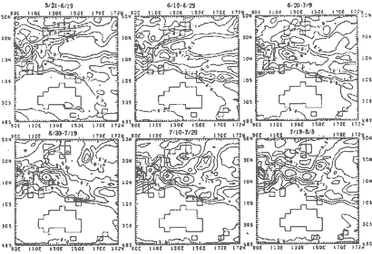
Figure 4. Same as in Figure 9 except for 1994.
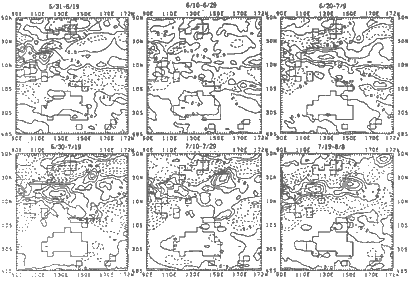
Figure 5. Plots of the spatial structure differences (1994-1993) of the first extended empirical orthogonal functions.
In order to compare between characteristics in 1993 and 1994, we have obtained the differences(1994-1993) of the spatial structure of the first mode in time. It is characterized that the strong negative value around Korea and Japan is shown during 20 June -29 July and the positive activity near 20N is sustained from 20 June. As a consequence, we can infer that the monsoon convective activity around Korea and Japan in 1994 is weaker than that of 1993, in contrast to the character in north region of east Asia, the convective activity in lower latitude in year in 1994 exists intensely and is stationary in character. One may thus conclude that the convective activity in 1994 doesn't move northward and continue to act at the lower latitude. The climatic variability which is producing this results is characterized as the' contrasting features between 1993 and 1994. It may explain that this characteristics is forced by the constraint of equatorial and subtropical condition.
Unlike, the first mode, the second EOF for 1993 and 1994 are relatively small on the contribution to total variance, however, the mode was produced by different character in 1993 and 1994. In 1993, the wave motion was concentrated on South China Sea, and in 1994 the wave motion was prominently represented at the western and northern borderline of Northern Pacific high. The second mode was not shown in the figures, but in order to out the outstanding period of the wave motion for convective activity over east Asia, Fourier harmonic analysis was performed.
3.2 Fourier harmonic analysis
Fourier harmonic analysis is performed to determine what types of wave m ode are pronounced over the analyzed area. The prevailing mode of intraseasonal oscillation in equatorial region and the different character between 1993 and 1994 are investigated.
Harmonic function which is derived from time series of high cloud amount at each grid point is represented as a function of wave number. Figure 6 shows the power amplitude as a function of wave number obtained from Fourier hannonic analysis. The ten symbols represent the. amplitude of different area separating by two degree longitude from 130E to 148E at equator. . Symbol x at wave number 12 has higher harmonic amplitude than any other symbol in 1993. In 1994, the most dominent symbol is y at wavenumber 3.
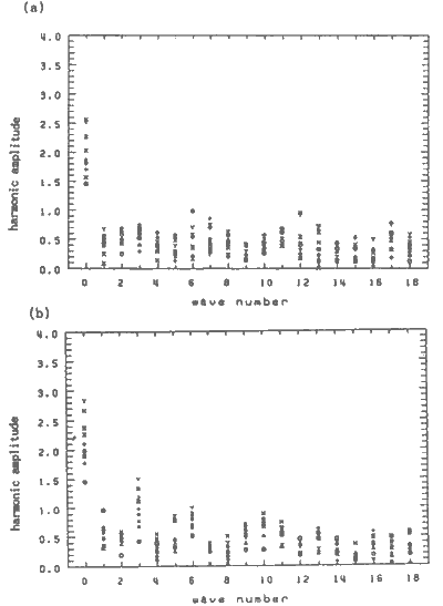
Figure 6. The plots of the power amplitude as a function of wave number obtained from Fourier harmonic analysis. The ten symbols represent the amplitude of different area separating by two degree longitude from 130E to 148E.
Then, it is possible to express over the equatorial and subtopical oceans. From the Fourier " analysis applied to the tropical and subtropical region, it is noteworthy that the difference ..between 1993 and 1994 in wave modes is recognized.
Figure 7(a) informs that 15.4 day mode is predominant also in subtrupical region. The 6 daymode is dominant in 1994 as shown Figure 7(b). The 15.4 day mode of the most prevailing mode in 1993 is known as the quasi-biweekly mode. Like this, The most prevailing modes over the central equatorial Pacific and Indian ocean was obtained differently, in 1993 the 61 day ; mode is represent and in 1994 this mode is weak in Indian ocean. Then it is probably a ~ judicious conjecture that the different climatic features between 1993 and 1994 may be claimed .significantly in terms of the 15 day and 61 day modes at lower latitude, raising the possibility that the contrasting monsoon precipitation in 1993 and 1994 may be more fundamentally related to the interaction of intraseasonal oscillations and seasonal variation of convective activities.

Figure 7(a). The prevailing modes of the intraseasonal oscillations over the equatorial and subtropical oceans for the period of 1 April 2 October 1993.
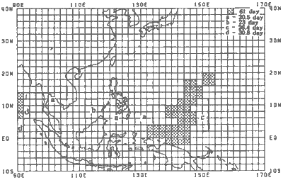
Figure 7(b). Same as in fig. 13 except for 1994.
4. Concluding summary
Rainfall is considered as an index for the strength of the east Asian monsoon. There are the contrast characteristics that we experienced a small amount of rainfalls in 1994 in comparison with 1993.
The evolution of high cloud amount for the period of summer monsoon amount is compared as a function of latitude.
EEOF analysis is used to investigate the principal characteristics of time evolutional structure, and Fourier harmonic analysis is applied to examine the activity of wave mode in equatorial Pacific region. The results can be summarized as following .
First, high cloud amount is compared for the each year through longitude-time cross section , averaged at 32-38N and 6-12N. There are strong convective activity during June and July in : 1993. The other hand, the monsoon convective activity for July in 1994 isn't appeared at the .region from 110E to 172W of east Asia.
Secondly, from the analysis of SST monthly difference, at lower latitude than near 18N, the on set time of monsoon in 1994 is represented as the faster tendency than that in 1993. And it is shown that the continuous increasing tendency is represented to the sourthward of 18N in 1994. By this result, it seems to be explained that the convective activity at lower latitude is strengthened lastingly.
Thirdly, from the difference (first mode in 1994 -first mode in 1993)analysis of the first mode obtained from EEOF analysis, a positive difference of convective activity appeared at the r' lower latitude than 20N, and a negative difference at the higher latitude.
Lastly, it is noteworthy that the wave activity in the equatorial Pacific is represented ~ differently for the contrasting years, 1993 and 1994. The 15 day mode and 31 day mode in 1993 r and 61 day mode in 1994 than any the other modes were relatively dominant in equatorial central Pacific and western Pacific. And the 61-day mode in 1993 was predominantly shown in the Indian ocean to the westward of 100E, and about 20 day oscillation was continuously existing over the east Asian monsoon region. From these results, we can infer that intraseasonal oscillation in equatorial Pacific, subtropical Pacific and Indian ocean plays an important role on the migration of the convective cluster to east Asia monsoon region during the monsoon period.
References
- Hendon, H. H., and M. L. Salby, 1994: The life cycle of the Madden- Julian oscillation. Atmos. Sci., 51, 2225-2237. :
- Knutson, T. R., K. M. Wickmann and J. E. Kutzbach, 1986: Glabal scale intraseasonal . oscillations of outgoing longwave radiation and 250mb zonal wind during northern hemisphere summer. Mon. Wea. Rev.,114, 605-623.
- Kousky, V. E., 1995: Climate diagnostics bulletin. Jan. 1995. Climate Analysis Center, National Meteorological Center, 78pp
- Krishnamurti, T. N. and N. H. Bhalme, 1976: Oscillations of a monsoon part I: Observational aspects. J. Atmos. Sri., 33, 1937-1954
- Lau, K. -M. and P. -H. Chan, 1986: Aspect of the 40-50 day oscillation during the northern ca summer as unfered from outpoing longwave radiation. Mon. Wea. Rev., 114, 1354-1367.
- Li, Tianming and B. Wang., 1994: The influence of sea surface temperature on the tropical intraseasonal oscillation: A numerical study. Mon. Wea. Rev, 112, 2349-2362.
- Madden, R. A. and P. R. Julian, 1971: Detection of a 40-50 day oscillation in the zonal wind in c, .} the tropical Pacific. j. Atmos. Sci., 28, 702-708.
- Maruyama, T ., T. Nitta and Y. Tsuneoka, 1986: Estimation of monthly rainfall from satellite-observed cloud amount in the tropical western Pacific. j. Atmos. Sci., 62, 88-108.
- Murakami, T. and J. Matsumoto, 1994: Summer monsoon over the Asian continent and western north Pacific. j. Meteor. Sac. Ja1Xln, 72, 719-745.
- Nitta. T ., 1987: Convective activities in the tropical western Pacific and their impact on the northern hemisphere summer circulation. j. Meteor. Soc. ja1Xln, 65, 373-390.
- Reynolds, R. W. and T. M. Smith, 1994: Improved global sea surface temperature analysis. j. Climate, 7, 929-948.
- Shen, S. and K. -M. Lau, 1995: Biennial oscillation associated with the east Asia summer monsoon and tropical sea surface temperature. J. Meteor. Soc. Ja1Xln, 72, 235-253.
- Tanaka, M., 1992: Intraseasonal oscillation and the onset and retreat dates of the summer monsoon east, southeast Asia and the western Pacific resion using GMS high cloud amount data. J. Meteor. Soc. Ja1Xln, 70, 1, 613-628.
- Tanaka, M., 1994: The onset and retreat dates of the Austral summer monsoon over Indonesia, Australia and New Guinea. j. Meteor. Sac. ja1Xln, 72, 235-253.