| GISdevelopment.net ---> AARS ---> ACRS 1995 ---> Global/Regional Change Study |
Satellite Estimation of
Environmental Variables by the Contextual Analysis Method: Validation in a
Seasonal Tropical Environment
T. Saravanapavan and Dennis
G. Dye
Global Engineering Laboratory
Institute of Industrial Science
University of Tokyo, Japan
Abstract
Global Engineering Laboratory
Institute of Industrial Science
University of Tokyo, Japan
Previous research suggests that a remote sensing contextual analysis method can be successfully used for estimating and mapping air temperature, soil moisture .conditions and atmospheric humidity at regional-to-global scales. Reported validations, however, have so far been limited to only mid-latitude temperate environments. We examine the robustness of the method in an application to sites in the seasonally moist tropical environment of Thailand. Our initial analysis focuses on the air temperature variable and employs 10-day composites of 1 km resolution normalized difference vegetation index (NDVI) data from the NOAA Advanced Very High Resolution Radiometer (A VHRR). For most sites our satellite estimates of air j temperature agree well with surface data, confirming that the method can be successfully applied in a seasonally moist tropical environment. Because our 10-day composite NDVI data may not adequately represent daily variations in temperature ,we anticipate improved results when the method is applied at the daily time scale.
1. Introduction
Spatial and temporal information on surface temperature, air temperature and soil moisture conditions is important for modeling and monitoring regional evapotranspiration and related biospheric processes, and for linking between the land surface energy budget and the hydrologic budget. Ground based measurements for these variables are commonly available for only a limited number and distribution of point locations. Interpolation techniques are often applied to generate continuous spatial data fields, but these techniques often introduce considerable uncertainty, particularly in regions where station coverage is sparse. Satellite remote sensing provides a means for estimating these variables in a direct and spatially comprehensive manner .
Research in recent years has led to the introduction of a "contextual" analysis approach that shows particular promise for estimating and mapping temperature, soil moisture conditions and atmospheric humidity (Goward et al., 1985, Nemani 1989, Goward and Hope 1989, Prihodko 1992, Goward 1994, and Prince and Goward 1995). The technique estimates temperature and soil moisture conditions based on the relationship between coincident spatial sample arrays of satellite-acquired data on the normalized difference vegetation index (NDVI) and surface temperature, and has been successfully tested in temperate mid-latitude environments. The method, however, has not yet been evaluated in tropical environments, which have energy, temperature and precipitation regimes that differ sustantially from than those of temperate latitudes. This study evaluates the robustness of the contextual analysis method through an application in the seasonally moist tropical environment of Thailand in Southeast Asia.
2. Background
The contextual analysis method takes advantage of the relation between vegetation cover (as expressed by the NDVI) and surface temperature (Nemani and Running,1989; Coward et al., 1994). Because the amount of vegetation in a landscape tends to be spatially heterogeneous, the observed surface temperature will vary accordingly. Satellite remote sensing of surface temperature, e.g. based on thermal infrared measurements with the "split window" technique (Price, 1983, 1984), enables these spatial variations to be measured and mapped. When coincident measurements of the NDVI are plotted against corresponding surface temperature measurements, the spread of points exhibits a negative slope. The slope tends to be negative because, as the vegetation cover in an observed landscape increases, the surface temperature decreases as a result of differences in heat capacity between bare soil and vegetation canopy, and the cooling effects of transpiration. The magnitude of the slope is sensitive to changes in the moisture conditions of the surface at the time of observation, primarily because of the variations in the magnitude of latent heat exchange by evapotranspiration. A fully vegetated landscape generally exhibits temperatures close (e.g. within :1:2°C) of air temperature (Coward, 1994). The air temperature may therefore be estimated by extrapolating the best-fit line through the NDVI of a full vegetation canopy (generally 0.7) and determining the surface temperature at that point. Variations in soil moisture conditions are expressed as variations in the slope of the relation between observations dates. In this initial analysis, we focus our attention to application of the technique to estimate air temperature in the seasonally moist tropical climate that characterizes Thailand.
3. Data and Methodology
Ten-day composites of NOAA-ll Advanced Very High Resolution Radiometer (A VHRR) data for 7 periods from April 1 to June 10, 1992, were obtained from the EROS Data Center. We applied the split-window technique of Price (1984) to estimate surface temperature. Because field measurements of surface temperature were not available for validation of satellite-derived surface temperature estimates, our analysis assumes that the surface temperature measurements are reliable. Five sample sites were selected for analysis based on the ready availability of climatic data (Table 1). The sites are Bangkok, Chiang mai, Khonkean, Ranong and Trang. Cloud cover in this tropical region is potentially interrupts the spectral measurements. We removed cloud-contaminated pixels by applying the gross cloud check and the thin cirrus test proposed by Saunders (1988). We applied the contextual analysis method for estimating air temperature by extracting surface temperature and NDVI values in coincident arrays with dimensions of 64 x 64 pixels.
| Site name | latitude (degrees) | longitude (degrees) |
| Bangkok | 13.73 | 100.57 |
| Chiang mai | 18.78 | 98.98 |
| Khonkean | 16.43 | 102.83 |
| Ranong | 9.97 | 98.63 |
| Trang | 7.52 | 99.63 |
Daily air temperature data for the five locations were averaged to correspond to the seven A VHRR composite periods. These measured data were compared with the satellite estimated air temperature for validation.
4. Results and Discussion
The observed NDVI-surface temperature relation displays the expected pattern, with increasing NDVI associated with decreasing surface temperature (e.g. Fig. 1). The satellite estimated air temperatures for the five sites and seven time periods are in general agreement with the ground-measured air temperature values (Fig. 2). The results, however, differ among the sample locations (Table 2). When data for all time periods are considered, the computed coefficient of determination (i) varies from a minimum of .03 at Chiang Mai to 0.81 at Khonkean. The poor results in terms of the value may be attributable to the influence of a limited number of extreme outlying values, most evident at Chiang Mai, Bangkok, and Ranong sites. The RMS differences range from a minimum of 0.7° C to 2.2 oC, suggesting that on average the method provides a reasonably high level of accuracy. The source of the variation requires additional investigation. The outliers are associated with the time of onset of the monsoonal rain period in Thailand, so they potentially reflect the effects of partially cloud contaminated satellite measurements that passed undetected by our cloud screening procedure. If we assume that the outliers do indeed represent artifacts and remove them from consideration, the results for all sites appear consistently good (Table 2). The r2 values then range from .46 to .93, and the RMS difference ranges from 0.4°C to 0.9°C.
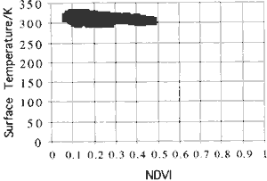
Figure 1. Observed relation between NDVI and surface temperature at Bangkok for period of April 11-20,1992. Surface temperature decreases with increasing NDVI. Higher NDVI indicates more vegetation cover. Air temperature is estimated by extrapolation of NDVI through the NDVI value of full vegetation cover, assumed as 0.7.Observed Air Temperature /(C)
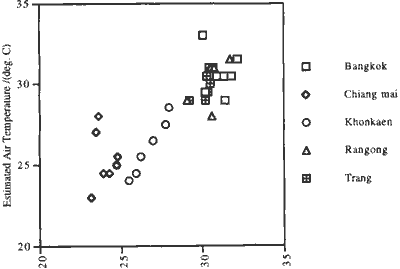
Figure. 2. Comparison of satellite estimated air temperature with the observed air temperature for the five sample locations and seven time periods.
Our use 10-day composite NDVI images to represent the mean air temperature conditions for time period requires further consideration. Because the composite procedure selects the maximum NDVI for the 10-day period to minimize cloud effects, the resultant NDVI images may be biased toward the temperature of the clearest day (i.e. highest NDVI). If temperatures vary during the composite period, the variation may not be adequately represented by the NDVI that is retained for the composite. We therefore expect that additional improvements in accuracy would be attained if the analysis is applied at the daily time scale, together with rigorous cloud screening. We are examining this possibility in our current research.
Although additional analysis is required, our initial results suggest that the contextual analysis method for estimating air temperature can be successfully and reliably applied in the seasonal moist tropics, but may depend heavily on the success with which cloud effects can be detected and removed. In our follow-on research we are expanding our analysis to include the surface moisture and atmospheric humidity variables.
| Location | r2 | RMS.D iff(0c) |
| Bangkok | 0.04(0.83) | 1.6(0.7) |
| Chiang mai | 0.03(0.93) | 2.2(0.4) |
| Khonkean | 0.81 | 019 |
| Ranong | 0.31(0.60) | 1.1(0.6) |
| Trang | 0.46 | 0.7 |
| All sites | 0.77 | 1.4(0.7) |
References
- Goward, S.N., and A.S. Hope. 1989. Evapotranspiration from combined reflected solar .and emitted terrestrial radiation: preliminary FIFE results from A VHRR data. Advances in Space Research 9 : 239-249.
- Goward, S. N., R.H. Waring, D.G.Dye and J.Yang. 1994. Ecological remote sensing at otter: satellite macro scale observations. Ecological Applications, 4(2), pp. 322-343.
- Goward, S.N..,.C. Cruickshanks, and A.S. Hope. 1985. Observed relation between
- thermal emissions and reflected spectral reflectance from a complex vegetable landscape. Remote Sensing of Environment 18 : 137-146.
- Nemani, R.R., and S.W. Running. 1989. Estimation of resistance to evapotranspiration from NDVI and thermal-IR A VHRR data. Journal of Climate and Applied Meteorology 28:276-294.
- Price, J.C. 1983. Estimating surface temperatures froIJ1 satellite thermal infrared data-a simple formulation for atmospheric effect. Remote Sensing of Environment 13:353- 361.
- Price, J.C. 1984. Land surface temperature measurements from the split window channels of NOAA 7 advance very high resolution radiometer. Journal of Geophysical Research 89,D5:7231-7237.
- Prince, S.D., and S.N. Goward, 1995. Global primary production: a remote sensing approach. Journal of Biogeography 22: 2829-2849.
- Prihodko, L. 1992. Estimation of air temperature from remotely sensed observations. M.A. thesis, University of Maryland at College Park.
- Saunders, R.W., K.T. Kriebel. 1988. An improved method for detecting clear sky and cloudy radiation from A VHRR data. Int. J. Remote Sensing, vol. 9, No.1, 123-150.