| GISdevelopment.net ---> AARS ---> ACRS 1995 ---> Global/Regional Change Study |
Developing Land Cover
Classification System for NOAA AVHRR Applications in Asia
Chandra Giri, Surendra
Shrestha
UNEP Environment Assessment Programme for Asia and the Pacific
Asian Institute of Technology
P.O. Box 2754
Bangkok 10501
Thailand
Tel: (66-2) 524-6236
Fax: (66-2) 516-2125
Email: grid@cs.ait.ac.th
Abstract
UNEP Environment Assessment Programme for Asia and the Pacific
Asian Institute of Technology
P.O. Box 2754
Bangkok 10501
Thailand
Tel: (66-2) 524-6236
Fax: (66-2) 516-2125
Email: grid@cs.ait.ac.th
In this paper, a land cover classification system for use with coarse spatial resolution remotely sensed data such as NOAA A VHRR, suitable for Asian conditions has been proposed. Considerations of Users' needs and sensor's capabilities in selecting land cover classes has been discussed. The need for harmonized and consolidated efforts to come up with better classification system, at different scale is noted.
1.0 Introduction
The classification system for remotely sensed data varies primarily with the kind of the satellite data used and the objective of the classification. Due to these variations, the nomenclature and definition of land cover types tend to vary considerably in the existing literature. As a result, today, comparison across time and space of land use has become very arduous ( Mucher et. al., 1993). Moreover, ambiguity in the mapping and classification criteria can often causes significant differences in the results of the interpretation (Singh, 1986). Efforts in developing standard and harmonized land cover types for Advanced Very High Resolution Radiometers (A VHRR) data interpretation is necessary as land cover cut across numerous sectors of resource management and the selection of classes plays an important role in the A VHRR analysis.
2.0 NOAA A VHRR Data
A VHRR data in 1 km resolution operated by the US National Oceanic and Atmospheric Administration are available either in LAC or HRPT .The data is suitable for macro assessment and monitoring of land cover status and their change patterns in near real time basis (Giri & Shrestha, 1995). Considering the strengths and weaknesses of the data (see Table 1), it can be said that this is the only option available for large scale assessment and monitoring of resources, at least for few years until the moderate resolution satellite data will be available in the market .
| Advantages | Disadvantages |
| 1. Synoptic coverage and hence low data Volume | 1. Coarse resolution (1.1 km at the Nadir) |
| 2. High radiometric resolution (10 bit) | 2. Pre-processing is time consuming |
| 3. Relatively low cost (Free!, only handling cost) | 3. The methodology in handeling AVHRR data for land applications is not well developed |
| 4. Twice daily coverage and hence high possibilities of having cloud free data. | 4. LAC data has limited capability to record on-board |
Negotiations are being held with China, India, Indonesia and Iran to extend the project in these countries. Two "hot spot" (major disturbance front) areas, one in Northern Laos and another in the Mekong Delta (Vietnam) have been identified for further investigation using high resolution satellite data such as LANDSA T TM and SPOT. Methodological guidelines on the use of A VHRR data for the assessment and monitoring of major land cover types in the region is being developed. These activities are expected to continue in 1995 and beyond.
The major land cover classes of interest were selected owing to the capability of the sensor to detect features on the earth's surface and their practical significance in the real world. For the purpose information such as variation in the phenological characteristics of the vegetation through different season and cropping system in the region were taken into consideration. Furthermore, information and experiences from previous similar exercises, guidelines prepared by UNEP/FAO on land cover/land use and experts' views on the field were also used in selecting classes. The principal aim is to harmonize the land cover classification system for regional aggregation and comparison.
The following diagram presents an overview of the land cover classification system.
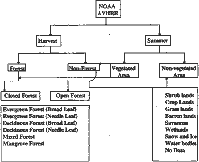
Figure 1 Land Cover Classification System
3.0 Classification Criteria
The underlying supposition in the analysis of remote sensing data is that each feature on the earth's surface records its unique signature in the sensor thus providing opportunities for discriminating between different objects on the earth's surface. Features on the earth's surface in-distinguishable with the satellite data should not be taken as a separate class. On the other hand, all the classes discernible by the sensor may not be of practical use to the users. A positive synergism of two is necessary in selecting land cover classes prior to the analysis of the satellite data. However, this will not overcome the possibility of incorporating secondary information with the help of GIS.
4.0 Classification Scheme
Once we have selected the classes, it is necessary to define them properly. There is a great tendency to mix two commonly used terms viz. land cover and land use, principally because these two are closely interlinked. Land cover can simply be defined as the physical attributes of the land that can be seen readily as opposed to the land use which describes a pattern of human activities undertaken within a social and economic context". Land cover has visual effects, visible by the remote sensor, as it is what covers the land at the time of satellite observation. Examples of land cover are forest, snow, grass land etc. with an exception of barren land without any cover.
More difficult problem can be encountered in defining individual land cover classes. Forest, for example, is the most controversial one. FAO has two definitions of forest, one for developing countries and one for developed countries. Forests for ;:; developing countries have been defined as an "ecological systems with a minimum crown "'" coverage of land surface (here assumed as 10 percent) and generally associated with wild flora, fauna and natural soil conditions; and not subject to agronomic practices". For developed countries on the other hand forest is "with tree crown cover (stand density) of more than about 20% of the area. Continuous forest with trees usually growing more than about 7 m in height and able to produce wood. " (FAO, 1993). The reason for defining forest differently for developing and developed countries is not mentioned in the report. The definition of forest in the International Geosphere Biosphere Project (IGBP), is based on the percent canopy cover and height. Land dominated by trees with a percent canopy cover greater than 60% and height exceeding 2 meters has been considered as forest in their definition. On the other hand, agriculture is widely used as a land cover but for some, it sounds more like land use and the alternative term "crop lands" has been proposed.
Numerous land cover classification systems exists at the global level. UNESCO's ': International Classification and Mapping of Vegetation (1973) based solely on the " ecological and physiological criteria is not much importance for use with remotely sensed data. FAO, The Forest Resources Assessment 1990 focuses more on the forest cover classification system with different methodologies in different parts of the world and fails to provide spatial distribution of forest within the territory .
The most comprehensive classification system at the global level for use with AVHRR 1 km satellite data has been proposed by the IGBP-DIS Global 1 km Land Cover Project. We felt it necessary to refine this classification system to be applicable in the Asian region. A new approach of land use and land cover classification systems for use with high resolution remote sensing data has been developed by Anderson et. al (1976) and a modified forest cover classification system in an Indian perspective has been proposed by Singh (1989). Neither of these methods provides a comprehensive means to deal with land cover classification systems for macro assessment in use with coarse resolution satellite data such as NOAA AVHRR.
The following criteria has been proposed through this paper for general use.
Tree height and percent crown cover are two quantitative parameters of forest widely used in classifying forest and non-forest areas and different categories of forest classes. F AO categorizes forest as closed forest if the percent canopy cover is greater than 40% and open forest it. the percent canopy cover is in the range of 10-40%. To be classified as forest the height of the tree should be greater than 7 meters. In IGBP classification system, percent crown cover should be more than 60% and tree height should be more than 2 meters to be classified as forest. This definition underestimates the forest acreage in Asia. For our purpose, neither method gives an accurate representation. Forest with 10-40% canopy cover and trees greater than 3 meters in height has been classified as open forest and that of percent canopy cover greater than 40% has been classified as closed forest. More research is necessary to correlate digital count with these two quantitative parameters. Till now, these two are determined based on the subjective .judgment
The above definition of forest is in compliance with the existing forest classification system in majority of the countries in the region with some exceptions. For example the definition of forest for developed countries (20% canopy cover) has been followed in China and in Lao P.D.R.
Phenology of the vegetation and season consideration that varies across countries, might be the best parameter to be taken into account to discriminate evergreen and deciduous forest Season and cropping patterns are vital in discriminating forest and non- forest areas and barren land and crop land. This is because barren land and harvested paddy field appear to be the same in the satellite data. Consideration should be given to the cropping systems. Special consideration is necessary to discriminate between clouds and barren land and clouds and snow.
6.0 Past Efforts
No general agreement on the global classification system exists and so is with regional and local. It is increasingly felt necessary to develop an international and well accepted system for land cover classification. However, experiences shows that by no means this broad categorization is sufficient for thematic use. A multi-level approach for defining the land cover classes need to be developed..
At the global level, efforts have been in place for standardization of land use and land cover classification system. A number of individuals and organizations have contributed their efforts in harmonizing land cover classes in the past UNEP and F AO jointly initiated a project in collaboration with the Institute of Terrestrial Ecology in UK for standardization of land use/and cover classification systems. IGBP and UNESCO are two other actors active in this field. USGS EDC planned to map the entire globe for the land cover before 1997. Land cover working group of Asian Association of Remote Sensing (LCWG/AARS) is also working on this.
7.0 UNEP's Effom in Asia
UNEP through its Environment Assessment Programme for Asia and the Pacific has been involved in macro scale land cover assessment and monitoring of selected countries in the region using A VHRR data and subsequently developing the land cover classification system at the regional/national level. Land cover mapping of Bangladesh, Cambodia, Lao. P.D.R., Myanmar, Nepal and Vietnam for the period of 1985/86 and 1992/93 was finalized in 1994. Data for Pakistan and Sri Lanka is being analyzed.
8.0 Definition of Land Cover class adopted by UNEP/EAP-AP
Forest: Land covered by trees with the percent canopy cover greater than 10%. Trees are woody plants with a single well defined stem and more than 3 meters in height. Forest with 10-40% canopy cover is classified as open ~ forest and with 40% and above is classified as closed forest.
- Evergreen Forest: Forests with green foliage throughout the
year.
Deciduous Forest: Forests that sheds their leaves in certain period of the year.
Mixed Forest: Forests consisting of mosaic of evergreen and deciduous forest.
Mangrove Forest: Tidal forests found near the sea shore.
Savannas: Land covered mainly with herbaceous plants in association with. Isolated trees.
Grassland: Land covered with herbaceous plants with less than 10% tree and Shrub cover
Wetlands: Land covered with mosaic of water and shrubs and woody Vegetation
Cropland: Land covered with agricultural crops
Show and Ice: Land covered with snow and/ or ice at the time of satellite Observation .
Barrenlands: Land without any land cover. This includes lands with shrubs and forests having less than 10% canopy cover.
Water Bodies: Land covered with rivers, lakes, estuaries.
No Data Available: Cloud covered or mountain shadowed areas.