| GISdevelopment.net ---> AARS ---> ACRS 1995 ---> Global/Regional Change Study |
Land Cover Classification
System for Continental/Global Applications
Ryutaro Tateishi*, Wen
Cheng Gang*, and L. Kithsiri Perera**
Center for Environmental Remote Sensing (CEReS), Chiba University
1-33 Yayoi-cho, Inage-ku, Chiba263, Japan
Fax: +81-43-290-3857
Email: tateishi@rsirc.cr.chiba-u.ac.jp
Weathernews Inc-
D21, 1-3, Nakase, Miharna-ku,Chiba261, Japan
Fax: +81-43-274-5012
Abstract Center for Environmental Remote Sensing (CEReS), Chiba University
1-33 Yayoi-cho, Inage-ku, Chiba263, Japan
Fax: +81-43-290-3857
Email: tateishi@rsirc.cr.chiba-u.ac.jp
Weathernews Inc-
D21, 1-3, Nakase, Miharna-ku,Chiba261, Japan
Fax: +81-43-274-5012
A new land cover classification system is proposed for continental/ global applications. In this study, a classification system is distinguished from a legend. A classification system is a category system for the classification work while a legend is a category system for the usage of a classified product. A legend is based on a classification system and different legends are possible from one classification system. The ..proposed classification system has a hierarchical structure with the possible extension of classes up to 255. The approximate resolution of satellite remote sensing image for the proposed classification system is from 25Om (future GLI sensor on ADEOS-II, Japan) to 8 km (sampled AVHRR). However detail land cover categories are included in the classification system in order to correspond to other maps and ground survey-
Another important feature of the system is that easily classified categories are in the higher level in the hierarchical classification system. This classification system is developed as the activity of the working group, "l-km Land Cover Database of Asia"(LCWG), in the Asian Association on Remote Sensing (AARS).
I. Introduction
One general problem of land cover legend is that there are many kinds of legends in different countries and different projects. This fact prevents data comparison, exchange and integration. This is why UNEP/FAO has a project on harmonization of land cover and land use classifications (UNEP/FAO 1993). The goal of this project is to make clear the relationships among different land cover/use classification systems both r within and between countries, both within and between applications, from national to regional to global ::- scales. In the International Workshop on Global Databases organized by the International Society for ~.. Photogrammetry and Remote Sensing (ISPRS) Working Group IV/6, the same problem was discussed (tateishi 1995a). One question in the discussion was "Is the standard legend possible?" The answer was No because users community is diverse and there are a variety of needs for land cover. However it was suggested to develop several standards for each of the users community. The important thing here is that a legend must reflect needs of users. It must be also noted that needs are not static. They will evolve over time.
The Land Cover WG(LCWG) of AARS was established in October 1993. The objectives of the production of land cover database of Asia by the LCWG, AARS are:
- First, global change studies (from scientific needs) and
- Secondly, land use management and planning (from social needs)
2. Classification system and legend
The word, "classification system", has been used as the same meaning as "legend". Land cover legend has been decided based on user needs in a country or in a project. The classified result is presented by the legend and its classification work has also been done according to the legend. When a legend has a hierarchical structure, a higher level category is not necessarily easier to be classified than a lower level category. For example, if "forest" and "shrubland" are higher categories than "evergreen" and "deciduous", higher categories are more difficult to classify by multi temporal low resolution satellite data. For this reason, a classification system is distinguished from a legend in this study. A classification system is a category system for the classification work while a legend is a category system for the presentation of a classified result. That is, multiple legends are possible from one classification system. What authors propose here is a land cover classification system, not a legend.
3. Proposed land cover classification system;
Table l(a) and (b) shows a proposed land cover classification system which has the following characteristics.
- Hierarchical structure
- Maximum number of possible land cover classes: 255
- Harmonization with internationally accepted land cover classification system
- Inclusion of Asian main land cover types A)
- Possibility to extend globally applicable classification system
- flexibility
- Unique classification among forest, shrubland and grassland
- Separated cropland into tree crops, shrub crops and grass crops
(b ): The classification system consists of 59 classes including 47 classes for vegetation, 8 classes for non vegetation, and 4 classes for water. Addition of new classes up to 255 is possible. Class code is recorded in one byte."
(c): The latest project to map global land cover by remote sensing is being done by the IGBP-DIS Land Cover Working Group which has established land cover classification system based on Running's methodology (Running 1994). In this classification system, forest are divided into four main classes such as Evergreen Broadleaf, Evergreen Needleleaf, Deciduous Broadleaf, and Deciduous Needleleaf. These four classes are introduced to the proposed classification system because discrimination of these classes are important for global change studies.
For example, Evergreen forest and shrubland (60) is included in Evergreen forest or shrubland (14), Forest or shrubland (12) and Vegetation (10). Therefore an explanation of Evergreen forest and shrubland (60) includes the explanation of the classes, 14, 12 and 10. That is, "Evergreen canopy cover > 60%" must be added to the explanation of Evergreen forest and shrubland (60)
| Vegetation | 10 | ||||||||||||
| Forest or shrubland | 12 | ||||||||||||
| Evergreen | 14 | ||||||||||||
| Forest | 16 | ||||||||||||
| Broadleaf | 18 | ||||||||||||
| Natural | 20 | ||||||||||||
| Tree crops | 22 | ||||||||||||
| Oil palm | 23 | ||||||||||||
| Coconut | 24 | ||||||||||||
| Others | 25 | ||||||||||||
| Needleaf | 36 | ||||||||||||
| Shruland | 42 | ||||||||||||
| Natural | 44 | ||||||||||||
| Shrub crops | 46 | ||||||||||||
| Tea | 47 | ||||||||||||
| Others | 48 | ||||||||||||
| Forest and shrubland | 60 | ||||||||||||
| Deciduous | 70 | ||||||||||||
| Forest | 72 | ||||||||||||
| Broadleaf | 74 | ||||||||||||
| Natural | 76 | ||||||||||||
| Tree crops | 78 | ||||||||||||
| Rubber | 79 | ||||||||||||
| Others | 80 | ||||||||||||
| Needleaf | 90 | ||||||||||||
| Shrubland | 92 | ||||||||||||
| Natural | 94 | ||||||||||||
| Shrub crops | 96 | ||||||||||||
| Cotton | 97 | ||||||||||||
| Others | 98 | ||||||||||||
| Forest and srubland | 110 | ||||||||||||
| Mixed forest or shrubland | 120 | ||||||||||||
|
Grassland |
130 | ||||||||||||
| Natural grassland/pasture | 132 | ||||||||||||
| Grass crops | 140 | ||||||||||||
| Paddy | 141 | ||||||||||||
| Wheat | 142 | ||||||||||||
| Sugarcane | 143 | ||||||||||||
| Corn | 144 | ||||||||||||
| Others | 145 | ||||||||||||
| Mixed vegetation | 160 | ||||||||||||
| Wetland | 170 | ||||||||||||
| Mangrove | 172 | ||||||||||||
| Swamp | 174 | ||||||||||||
| Little vegetation | 180 | ||||||||||||
| Tundra | 182 | ||||||||||||
| Others | 184 | ||||||||||||
| Non vegetation | 190 | ||||||||||||
| Bare ground | 191 | ||||||||||||
| Rock | 192 | ||||||||||||
| Stones or gravel | 193 | ||||||||||||
| Sand | 194 | ||||||||||||
| Clay | 195 | ||||||||||||
| Perennial snow or ice | 200 | ||||||||||||
| Built-up area | 210 | ||||||||||||
| Water | 220 | ||||||||||||
| Inland water | 222 | ||||||||||||
| Water with seasonal change | 224 | ||||||||||||
| Tidal flat | 226 |
| Class code: Class name and Explanation |
| 10: Vegetation Vegetation but cannot be interpreted into any class from 12 to 184; hereafter the meaning of the underlined part is written like (12-184) |
| 12: Forest or shrubland (14-120)
Forest or shrubs canopy cover is > 60% |
| 14: Evergreen forest or shrubland (
16-60) Canopy is never without green foliage. Evergreen canopy cover > 60% |
| 16: Evergreen forest (18-36) Forest canopy cover is > 60%. Tree height is exceeding 2 meters. |
| 18: Evergreen broadleaf forest (20-25) |
| 20: Natural evergreen broadleaf forest |
| 22: Evergreen broadleaf tree crops (23-25) |
| 23: Oil palm |
| 24: Coconut |
| 25: Others |
| 36: Evergreen needleleaf forest |
| 42: Evergreen shrubland (44-48)
shrubs canopy cover is > 60%. Tree height is less than 3 meters. |
| 44: Natural evergreen needleleaf shrubland |
| 46: Evergreen shrub crops (47-48) |
| 47: Tea |
| 48: Other evergreen shrub crops |
| 60: Evergreen forest and shrubland
10% < forest canopy cover < 60% 10% < shrub canopy cover < 60% |
| 70: Deciduous forest or shrubland
(72-110) With an annual cycle of leaf-on and leaf -off periods. Deciduous canopy cover > 60%. |
| 72: Deciduous forest (74-90) Forest canopy cover is > 60%. Tree height exceeding 3 meters. |
| 74: Deciduous broadleaf forest (76-80) |
| 76: Natural deciduous broadleaf forest |
| 78: Deciduous broadleaf tree crops (79-80) |
| 79: Rubber |
| 80: Other deciduous broadleaf tree crops |
| 90: Deciduous needleleaf forest |
| 92: Deciduous shrubland (94-98)
Shrub canopy cover is > 60%. Tree height is less than 3 meters. |
| 94: Natural deciduous shrubland |
| 96: Deciduous shrub crops (97-98) |
| 97: Cotton |
| 98: Other deciduous shrub crops |
| 110: Deciduous forest and shrubland
10% < forest canopy cover < 60% 10% < shrub canopy cover < 60% |
| 120: Mixed forest or
shrubland Neither evergreen nor deciduous forest or shrubs exceeds 60% of coverage. |
| 130: Grassland (132-145) Tree and shrub cover is less than 10%. |
| 132: Natural grassland / pasture |
| 140: Grass crops (141-145) include cereal and other grass type crop |
| 141: Paddy |
| 142: Wheat |
| 143: Sugarcane |
| 144: Corn |
| 145: Other grass crops |
| 160: Mixed vegetation 10% < forest or shrub canopy < 60% 10% < grass cover < 60% include savanna and mixed land with cropland, shrubland, forest and few houses |
| 170: Wetland (172-174) |
| 172: Mangrove |
| 174: Swamp Any type of wetland with vegetation except mangrove |
| 180: Little vegetation (182-184)
Vegetation cover is more than 10 % at the peak season |
| 182: Tundra |
| 184: Others |
| 190: Non vegetation
(191-210) Vegetation cover is less than 10 % at any time of a year |
| 191:.Bare ground (192-195) |
| 192: Rock |
| 193: Stones or gravel |
| 194: Sand |
| 195: Clay |
| 200: Perennial snow or ice |
| 210: Built-up area |
| 220: Water (222-226) |
| 222: Inland water Lake, pond, river, reservoir |
| 224: Water with seasonal
change Inland water with dry period |
| 226: Tidal flat |
(d): One of the main concern in land use management and planning in Asian countries is agricultural land. 'j Therefore main crop types are included in the classification system.
(e): Unique land cover classes in African or American continent can be added as a new class.
(f): The proposed land cover classification system is not a fixed one. It can be improved by addition of : classes or modification of system. For example, once all forest and all shrubland in the global area are -classified correctly, "Forest or shrubland (12)" will be removed and new classes, "Forest" and : "Shrubland" , will come to the second highest level of the hierarchical system. And "Evergreen forest ( 16)" ..and "Deciduous forest (70)" will be included in the "Forest" (g): Classification of Forest, Shrubland, and Grassland
(g): For the purpose of global change studies, the discrimination of vegetation into forest, shrubland, and grassland is important. Shrubs is small woody plants that are branched from the base. The proposed system used a threshold value of 3 meters height to distinguish shrubland from forest. As shown in Figure l(a), there are logically seven categories in the combination of forest, shrubland and grassland such as F, S, G, FS, SG, FG, FSG in the figure. Since the category of FSG is too detail, FSG is divided into Mfs, Msg, and Mfg and these three are combined to FS, SG, and FG, respectively (see Figure 1 (b ". By this alternation, seven categories are reduced to six categories. Moreover, since the discrimination between forest and shrubland by low-resolution satellite remote sensing data is difficult, two categories, "Forest" and "Shrubland" are combined into a larger category, "Forest or shrubs". Similarly, FG and SG are combined into a larger category," Mixed vegetation". Finally, seven categories in the figure are merged into three categories such as "Forest or shrubs (code: 12; F, S, FS, and Mfs)", "Grassland (code: 130; G)", and "Mixed vegetation (code: 160; FG, SG, Mfg, and Msg)" as shown in Figure l(c).
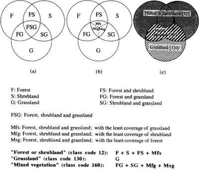
Figure 1 Forest, Shrubland and Grassland
(h): Cropland is divided into tree crops (code: 22 or 78), shrub crops (code: 46 or 96) and grass crops -0: (code: 140) because the discrimination between cropland and natural vegetation by low-resolution satellite remote sensing data is generally more difficult than the discrimination between "Forest or shrubs" and " "Grassland".
4. Examples of legends
Based on the land cover classification system as shown in Table 1, some legends can be established. The following shows relationships between a category, "Forest" (and a category, "Shrubland"), in a legend and class codes in the land cover classification system.
Forest: class code 16+ 18+20+22+23+24+25+36+ 72+ 74+ 76+ 78+ 79+80+90 + part of 120 + part of 12 + part of 10
Shrubland: class code 42+44+46+47+48+92+94+96+97+98 + part of 120 + part of 12 + part of 10
5. Conclusion
The Land Cover Working Group of AARS proposed a new land cover classification system in this paper. Any comments or opinions about the proposed classification system are welcome to improve it. Based on the classification system, land cover dataset of Asia with 8 km resolution is developing.
Acknowledgements
The land cover classification system proposed in this paper has developed by the cooperation with 49working group members from 28 countries. Authors would like to thank all working group members for their valuable cooperation. Authors would also thank Dr. Colin Mitchell of ISMARSC Limited for his detail comments to the land cover classification system.
References
- Running, S.W., T.R. Loveland, and L.L. Pierce," A Vegetation Classification Logic Based on Remote Sensing for Use in Global Biochemical Models", Ambio, \()1.23, No.1, 1994
- Tateishi, R., C. Wen, and K. Perera, "Working Group Report and Land Cover Database of Asia ", Proc. 15th ACRS, 17-23 Nov., 1994, pp. M
- Tateishi,R.(Ed.), "Report of the International Workshop on Global Databases", International Archives of Photogrammetry and Remote Sensing, Vol. XXX, Part 4W1, Boulder, 30-31 May, 1995a
- Tateishi,R., "Land Cover Database of Asia", Proceedings of the International Symposium on Vegetation Monitoring, Chiba, Japan, 29-31 August, 1995b
- UNEP/FAO, "Report of the UNEP/FAO Expert Meeting on Harmonizing Land Cover and Land Use Classifications", Geneva, 23-25 November, 1993