| GISdevelopment.net ---> AARS ---> ACRS 1995 ---> Global/Regional Change Study |
Nakhon Ratchasima, Resources
Atlas
C. Mongkolsawat and NRCT
Sub-committee on landuse, agriculture and
forestry
Abstract The objective of this study is to establish a spatial information system essential for : provincial resources planning. Nakhon Ratchasima, a province in Northeast Thailand was selected for this study. The province covers an area of about 12,778 sq.km. and is 260 kms from Bangkok. The spatial information needed was evaluated in terms of data availability as well as its reliability and compatibility. This includes an analysis of spatial data and its associated attributes as related to system structure. Methods for efficient data conversion have .been developed in consistent with the application scale. Spatial data was georeferenced, based on the Universal Transverse Mercator (UTM) used by the Royal Thai Survey Department. The spatial intonation established was organized by theme into layers. Those layers include administrative boundaries, infrastructure, land resources, digital terrain model, biological .resources and socio-economic aspects. The system developed provides a tool to search spatial information on resources of the province. The hardcopy outputs are also carried out to provide basic spatial information to publics. In addition, with the set of themes and conditions . Identified as related to the problem, spatial modeling can be performed accordingly.
I. Introduction
The 7th National Economic and Social Development plan (1992-1996) called for concommitance of natural resources management and sustainable economic growth (NESDB 1992). The plan describes development issues and problems faced by each natural resource. Natural resource and environmental concerns have been integrated into the regional development master plan. To formulate the plan, it is necessary to gather information in from best suited for management. The information to be collected should include spatial form and its associated attributes. A number of agencies in Thailand have a mandate in establishing information mostly in sectoral and specific form. With regarding spatial information, there exists paper maps with various scales and standards which have significant effect on the creation of spatial databases and ultimately on the integration and modeling. With advancement of technology (remote sensing and GIS), it is now possible to effectively establish spatial information and to formulate the integrated development plan. The National Research Council of 'Thailand (NRCT) then decided to make inventory of resource information to support the formulation of the provincial resource management plans. The work was assigned to a study team consisting of a number of government agencies concerned. This is to avoid duplication in setting up database and lowering the expenses. Moreover, the resultant information for each theme will be accordance with the system developed by the agency and provide consistent information to all of the users. In the same time, information can be updated and collected in form and manner suitable for modeling and integration.
2. Objectives
The objectives of this study are:
- to make inventory of resources of Nakhon Ratchasima Province using satellite data.
- to establish spatial resource database for management strategies
Nakhon Ratchasima (NR) Province is situated in the Northeastern part of Thailand (Figure 1 ). The annual rainfall in most part is less than 1000 m.m. Geologically, the area is formed by a thick sequence of Mesozoic sediments, the Khorat group, ranging in age form upper Triassic to Tertiary and Tertiary igneous rock. The Mesozoic sequence has been devided into 5 formations: Phra Wihan, Sao Khua, PhuPhan, Khok Kruat and Mahasarakham. The area is drained by a number of rivers from southwest direction into the Mun River. The central parts of the province are formed by flat to gently undulating alluvial plains with prominent raised margin to the southwest. The land ecosystem of the area can be divided into 2 main systems1:alluvial plains with gently undulating topography and 2) dissected erosion surface and mountain with variation in vegetation density. The former mostly consists of agricultural landuse and scattered remnant tree, the later includes protected forest area, recreation land and different kind of agricultural landuse.
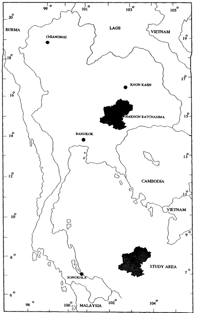
Figure 1
4. Methodology
4.1 Evaluation of existing information
The objectives of this phase are
- To identify all existing databases produced by Governmental agencies its characteristics, format and reliagility.
- To define data layer for establishing resource atlas and its associated attributes.
4.2 Establishment of database
4.2.1 Data collection
The current informations available both in digital and paper map were assembled and collected. Data for resource atlas could be acquired from the following sources:
- Existing maps
Topographic maps (1 :50,000) : Produced by the Royal Thai Survey Department is among the most important data as geo-referenced map, and basic spatial information.
Thematic maps:
A number of organizations in Thailand have produced thematic maps that can be used as input to the system. These include soil, geology, forest, watershed class quality, protected forest area, water resources and etc. - Other information
Socio-economic data, e.g. census data from the National .Office forStatistics, national rural development data (NRD2C) can be defined and converted Into digital spatial form.
Rainfall data from the Meteorological and Royal Irrigation Departments. - Satellite data
Satellite data offer the most updated information suited to input into the system. Continued development in earth observation satellites has made it possible to collect a wide variety of spatial data. Analysis of satellite data both analog and digital forms provided information on current landuse, forest, water resource, landform and etc.
Much of data collected in the study area are available in paper maps which have various accuracies and standards. Prior to input data in the system, preprocessing was performed. The preprocessing included auditing, editing, mosaicing and recitifying. The rectification and other preprocessing related to accuracy based on the topographic map. The updating informations were also undertaken using satellite data and field survey for landuse, .water resources, landform and some features concerned.
4.2.3 Data analysis
Data can be analyzed using a GIS for a number of functions: to establish and manage database ,and to perform modeling. Graphic database and its associated attributes are organized in theme layers. For each layer, the system uses vectors to create line drawing of geographic elements which are rasterized for analysis. The bridging between polygon and its associated database record was performed through Identification numbers. Each polygonal layer has its own database in which to store attributes. Each structure of attribute database permits the user to relate many data tables through a common item.
4.2.4 Spatial data output
A selected theme layer or combination of layers are plotted in either vector or raster form, including a related legend. Graphic and its associated attributes can be accessed from the system.
5. Results and Discussions
5.1 Theme layers organization
Spatial and attribute data in Nakhon Ratchsima can be grouped and defined in terms of themes as follows:
- Physical Resources
- Administrative boundary
- Amphoe & Tarnbon
- Topography
- Contour lines
- Landform
- Administrative boundary
- Climate
- Rainfall
- Temperature
- Relative humidit
- Natural Resources
- Geology, Soil
- Water resources, Forest resources
- Landuse, Touristic resources
- Human Resources
- Population
- Education
- Infrastructure
- Transportation networks
- Electricity
- Water supply
- Telecommunication
- Economics
- General economics
- Land tenure
- Industry
The theme layers established can be displayed in both map and statistical forms. The method of display are hard-copy maps and its description, statistical tables, graphs and digital map. However a resource manager often need hard copy map to use as the basis of planning work and discussing program. To serve a.." basic needs of users the map will be published together with its detailed description. Examples of the spatial informations on sub-district (Tambon) population density and watershed quality class are illustrated in figure 2 and 3 respectively.
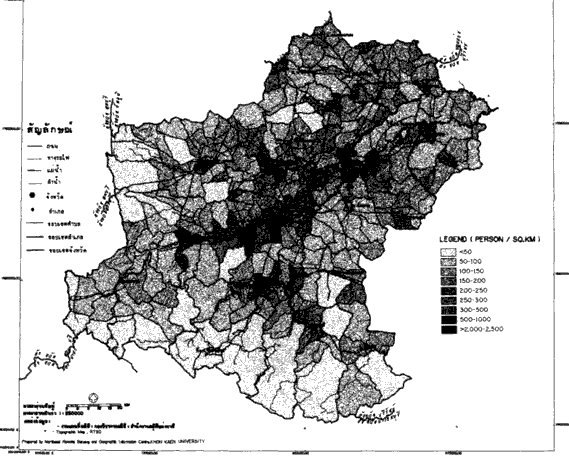
Figure 2

Figure 3
5.3 Application of the database
The system provides spatial data and its associated attributes. It is possible to offer either individual layer or a combination of layers. With selected theme layers, it is possible to formulate spatial model for resource strategies. To select theme layers for spatial modeling, the set of relationship should be reviewed and studied. This is to ensure that the information meets the need of parameterizing the model.
6. References
- DMR Group Inc. 1989. A corporate Land Information Strategic Plan for the GovenUl1ent of British Columbia, Victoria.
- Institute of Applied Science. 1969. Resources Atlas, Nakhon Phanom. Advanced Research Project Agence (ARPA) lJS. Dept. of Defence.
- Institute of Applied Science. 1971. Resources Atlas, Sakhon Nakhon. ARPA. US. Dept of Defence.
- McCloy Keith R. 1995. Resource Management Information Systems Talar & Francis. London
- Mongkolsawat .C Thirangoon .P and Sowana .A 1995. Spatial Decision Support System for Landuse Planning within a Watershed Area. Proceedings of the GIS AM/FM ASIA'95 August 21-24,1995 Bangkok.