| GISdevelopment.net ---> AARS ---> ACRS 1995 ---> Forest/Vegetation Mapping |
Integration of Geographic
Information System and Area Production Model (Apm) In the Prediction of
Forest Degradation at Phrao District, Thai Land
Yousi ali Hussin Vicente
Ato Alfred De Gier
The International Institute £or Aerospace Survey and Earth Sciences (ITC) 7500 AA Enschede, The Netherlands
Fax: (31) (53)874-399
E-mail: mailto:HUSSIN@ITC.NL, DEGIER@ITC.NL
Abstract
The International Institute £or Aerospace Survey and Earth Sciences (ITC) 7500 AA Enschede, The Netherlands
Fax: (31) (53)874-399
E-mail: mailto:HUSSIN@ITC.NL, DEGIER@ITC.NL
Recent decades have brought profound changes in the patter of land use in many developing countries. One of the clearest indicator of this changing to the land use pattern is the dramatic decline of natural forest cover, especially in the tropics. The increasingly rapid destruction of tropical rainforests is now at the center of world attention, prompting professional foresters and politicians alike to find ways to control, stop, and even reverse this process. Given the speed of the process, two issues are clear: actions are needed without undue delay, and a sustainable effect of such actions can be expected only if the causes are tackled. The problem thus needs to be examined from a cause- effect point of view.
The objective of this research was to explore the possibility of linking the results of remotely sensed data classification with numerical output of the area production model in a GIS environment in order to validate and predict forest degradation in Phrao district, Chiang Mai province, Thailand.
Introduction
A major cause of forest destruction is the need for more agricultural land, which in turn is a consequence of rapid population growth. The need for , timber, fuel wood and cash also influence deforestation. Recognizing the important role natural .resources in their national development, , governments in many develop1ng countr1es have shown great concern to save their remaining forest. Solutions are urgently needed. Controlling the continued degradation of the tropical forest can only be successful when detailed knowledge is obtained about the expected trend of degradation. There is a need for effective monitoring of these changes in time so that effective measures can be taken to counteract the ,situation. Timely and appropriate information in this required to prov1de decision makers and forest managers as basis for action in order to abate the current deterioration of the forest. Remote sensing and GIS can help government planners and policy makers to decide on what step they can adopt wh1ch w111 best stop the degradat1on and meet the demand of the populat1on for food and fiber. Prediction model can effectively provide bases for possible future scenarios about the status of forest.
Aside from unsustainable logging, the main cause of the contraction of most tropical forest lands in the world is the gradual expansion of agricultural r frontier into areas which were formerly reserved or classified as forest..' (Cernea, 1993) .Among others, expansion of agricultural lands is driven by the increasing population and the socio-economic policy of a nation.
While population growth is but one of the many factors, it is , exceptionally significant factor. The rapid increase of human number imposes r unsustainable burden to the forest resource base in two ways; there is a growing r demand for forest products (i.e. timber, fuel wood, etc.), and the need to feed a larger population will increase the pressure to clear forest areas and convert " them to crop farming. Moreover, the scarcity of land in the lowlands triggers I marginalized farmers to migrate to the uplands, bringing with them their lowland t' farming technology that may aggravate to the destruction of the forest. r Expansion of farmland has been the primary means through which agricultural production has been increased to meet both the subsistence needs of a growing population and the demand of domestic and agricultural commodity export markets. The increasing area of farmland per capita of agricultural population however, reflects increasing farm area allocated to upland field crops, three crops, other agriculture related activities, and farmland allocated for grazing or fallow and non-agriculture uses.
Likewise, most analysts agree that it is the factor associated with the economic development of the country that has been the most important driving force underlying the land coversion process. These force have contributed to both depletion and displacement of forest resources. Government policies in many developing countries are biased towards production rather than conservation. As a result, natural resources are over exploited in favour of the much needed foreign exchange. Moreover, the construction of role in opening remote forest areas. once access is available, a cascade of events towards forest destruction is inevitable.
Recognizing the import role of natural for national development, governments in many developing countries have shown great concern to save their remaining forest. Solutions are urgently needed. Mitigation of the continued degradation of the tropical forest can only be successful when detailed knowledge is obtained about the expected trend of degradation. There is a need for effective monitoring of these changes in time so that effective measures could be taken to counteract the situation. Timely and appropriate information is thus required to provide makers and forest managers as basis for action in order to abate the current deterioration of the forest. these information also help government planners and policy makers what step to adopt that will best meet the demand of the populations and balance the need to protect the environment. simulation models can effectively provide bases for possible future scenarios about the status of the forest. These help decision makers at the policy level and enable them to examine possible alternatives through identifying consequences of various strategies under given conditions (Shimada, 1986). Information about forest area changes is necessary to monitor effective forest management.
The use of remotely sensed data and geographic information system (GIS) are now gaining more and more importance as tools in natural resource management. Satellite observations about proximate sources of land cover change. Under GIS, data obtained from satellite observation can be easily integrated and analysis is facilitated. Information produce from GIS can be stored and retrieve easily in forms that are more useful and understandable by the users like policy and decision maker or project implementers.
The development of the Area production Model (APM) has been an important step in predicting land use changes. he APM is intended for simulation of long-term land use changes and the prediction of primary and secondary yields from agricultural and forest lands. Among other things, the model simulates the future need for agricultural products and land are generated primarily by the growth rates of population and GDP, and by changes in land productivity. The model is comprehen-sive, but does not have excessive data requirements.
De Gier and Hussin (1993), Hussin et al., (1994) and De Gier et al. (1995), have resolved the model spatially, automatically operate the model in ILWIS GIS and apply it to an area in East Java, Indonesia. This implementation include land transfer part of the model.
The objective of this research was to explore the possibility of linking the results of remotely sensed data classification with numerical output of the area production model in a GIS environment in order to predict forest degradation in phrao district, Chiang Mai province, Thailand.
Methodology
The research method shall be based on five main steps. The outline of the general methodology is shown in Figure 1. These five steps are:
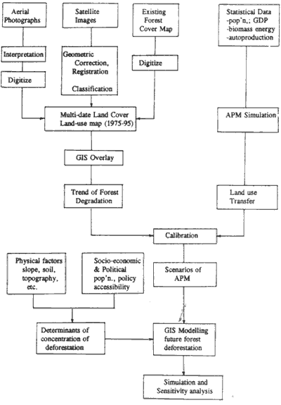
Figure 1. the general research methodology.
- Mapping the land use/covers for different years (1975-1995) . These maps will be produced from satellite images, aerial photographs and/or ortho-photos. Existing forest cover maps will be gathered from relevant offices during the field work. Base on the multi-temporal land cover land use maps, the trend of deforestation and forest degradation will be assessed.
- Simulating of agricultural development using APM. Data required to run the APM will be gathered during the fieldwork. Results of APM simulation will be analyzed and interpreted.
- Regression analysis between agricultural expansion and deforestation will be achieved. The results of steps A and B will be compared. Correlation and regression analysis will be conducted in order to calibrate the model's prediction of expansion of agricultural land with the decreasing trend of forest. The regression model will be the basis of developing a spatial model to predict forest degradation.
- Analysis of factors affecting deforestation. Environmental factors such as soil type and fertility, slope topography, topography, aspect, etc., as well as accessibility factors and population and market concentrations will be analyze in relation to the spatial concentration of deforestation in the study area through GIS operations.
- Development of spatial model to predict forest degradation. The results of steps 3 and 4 will be combined as input to develop a spatial model to predict future location of forest degradation.
Because the authors just came back from the field work and still running the analysis, given the due date of submitting this manuscript, it was difficult to present results in this paper. However, hopefully during the conference, the authors will presents the results and a handouts to the conference attenders.
Reference
- CERNEA, M.M. 1993. "Strategy options for participatory reforestation. development dialogue". Vol 14, No. 2: UN Centre for Regional Development, Nagoya, Japan.
- De Gier A. and Y. A. Hussion. 1993. "Spatially Resolved Area Production Model in Kali Konto, Indonesia Minneapolis, Minn., USA. Vol 1. 157-169pp.
- De Gier, A., Bode J. and Y.A. Hussin. 1993. "Spatially Resolved Area Production Modal in Kali Konto, Indonesia". GIS/LIS '93 proceedings. 31 October-4 November, 1993 Minneapolis, Minn., USA. Vol 1. 157-169 pp.
- De Gier, A., Bode J. and Y. A. Hussin. 1995. " Simulating forest degradation: the application of a Gis -based area production model in Kali Kanto, East Java, Indonesia." Proceedings 16th Asian Conference on Remote Sensing, Suranaree University of Technology, Nakhon Ratchasima, Thailand, 20-24 November 1995. (In press) .
- Hussin,Y.A., A. de Gier, and Hargyono. 1994. "Forest covet change detection analysis using remote sensing: A Test for the spatially resolved area production model". Fifth European Conference and Exhibition on Geographic Information Systems EGIS '94 Proceedings. Paris, France. Vol. II, 1825 - 1834 pp.
- SHIMADA,T.1986. "APM case study: East Java Province, Indonesia. Manual for Using the Area Production Model. Field Document 12:2. FAO, Bangkok. 99pp.