| GISdevelopment.net ---> AARS ---> ACRS 1995 ---> Forest/Vegetation Mapping |
Monotoring of Wetland
Vegetation Distribution and Change by using Microwave Sensor Data
Yoshifumi
Yasuoka1, Yoshiki Yamagata1, Masayuki
Tamura1, Mikio Sugita1 Jatuporn
Pornprasertchai2, Supapis Polngam2, Rachen
Sripumin2 Hiroyuki Oguma3 and Xidong
LI4
1. National Institute for Environmental Studies
16-2 Onogawa, Tsukuba, Ibaraki 305 Japan
2. National Research Council
196 Phaholyortin Rd., Bangkhen, Bangkok 10900, Thailand
3. National Space Development Agency, EORC
4. 7-15-17 Roppongi, Minato, Tokyo 106 Japan
4. Pasco Corporation
1-1-2 Higahiyama, Meguro, Tokyo, Japan
Abstract
1. National Institute for Environmental Studies
16-2 Onogawa, Tsukuba, Ibaraki 305 Japan
2. National Research Council
196 Phaholyortin Rd., Bangkhen, Bangkok 10900, Thailand
3. National Space Development Agency, EORC
4. 7-15-17 Roppongi, Minato, Tokyo 106 Japan
4. Pasco Corporation
1-1-2 Higahiyama, Meguro, Tokyo, Japan
The purpose of the study is to investigate remote sensing methodologies for monitoring actual vegetation distribution and its change in wetland by utilizing microwave sensor (SAR) data from ERS1 and JERS-1 together with optical sensor data from LANDSAT TM, JERS-1 OPS and SPOT HRV
The study includes the investigation on the microwave/landcover interaction mechanism in vegetated areas and also the development of the algorithms for vegetation classification by using SAR data. First, the relation between SAR image intensities and vegetation types and conditions has been investigated based on a set of ground survey data and overlayed satellite imageries from L-band SAR (JERS-1), C-band SAR (ERS-1), JERS-1 OPS, LANDSAT TM and SPOT HRV. Next several SAR data processing methods for vegetation classification have been investigated. Vegetation classification methods include both of the statistical approaches and texture analysis approaches. The methods were applied to the data at Kushiro Mire in Hokkaido, Japan and Prachuap Khirikhan Wetland in Thailand.
It was found that there is no clear relation between vegetation types and single SAR data in both of JERS-1 and ERS-1 SAR whereas combination of multi-seasonal SAR data is very effective for actual vegetation classification in wetland areas. The difference between JERS-1 and ERS-1 SAR data for wetland vegetation classification has been also investigated.
1. Introduction
Wetland is one the most valuable ecosystem on the earth. If abounds biological and are treasure houses of living things. Also today the importance of wetland is pointed out as a major emission source of methane which is one of the green house gases. As changes in wetlands are rapid and serious due to various human activities, it is urgent to monitor wetlands and their surrounding environment from physical, biological or social viewpoints. Ground survey of wetland is, however, not easy because of its difficulty of approach there (1). Remote sensing is expected to provide us an efficient tool for monitoring wetland environment. In particular, as wetland is characterized by a mixture of vegetation, soil and water, microwave remote sensing is expected to delineate the relation between them. This paper describes remote sensing methodologies for monitoring wetland environment with special emphasis on the application of SAR data of vegetation classification.
This study has been conducted as a part of the Joint Research between national Institute for Environmental Studies (NIES), Japan and National Research Council of Thailand (NRCT) sponsored by the Special Co-ordination Funds of Science and Technology Agency of Japan, and Also as a part of the JERS-1 Research Announcement (RA) program by National Space Development Agency (NASDA) of Japan.
First, the relation between SAR image intensities and vegetation types and conditions has been investigated based on a set of Ground survey data and overlayed imageries from ERS-1 SAR, JERS-1 SAR and OPS LANDSAT TM and TM and SPOT HRV. And next several data processing methods have been developed for the classification of SAR data. Vegetation classification methods include both of the statistical approaches and texture analysis approaches, and they have been applied to a single SAR image and also to a set of multi seasonal SAR images.
Two test sites, Kushiro Mire in Hokkaido, Japan and Prachuap Khirikhan Wetland in Thailand were selected as test for the study. In this paper the results as Kushiro Mire are primarily described Kushiro Mire is the biggest wetland in Japan and its extent is around 29,000 ha. The dominant species in vegetation are Sphagnum, Sedge, Reed and Alder. Kushiro Mire has been facing serious environmental problems due to regional developments.
It was found that there is no distinctive relation between vegetation types and single SAR data in both of JERS-1 and ERS-1 SAR whereas. One of the reasons for it is that SAR data reflects land surface conditions including water inundating or soil moisture condition as well as vegetation conditions. The difference between JERS-1 and ERS-1 SAR data for wetland vegetation classification has been also clarified.
2. Over lay Analysis between Vegetation and SAR Images
Satellite imageries from JERS-1 SAR, ERS-1 SAR, LANDSAT TM and SPOT OPS, and other landcover data including vegetation maps were registered each other, and relation between them were analyzed. At Kushiro Mire, first, in order to get base data for wetland vegetation distribution, vegetation were classified into seven categories including Sphagnum, Sedge, Reed, Alder, open water, forest and others by using three season LANDSAT TM imageries from spring, summer and autumn in1991which represent the seasonal variations of vegetation conditions (Fig. 1). Three dates images were registered each other and combined into eighteen bands images. Here, for each date image, six bands (Band 1-5 and 7) from visible and near-infrared were used for classification. The maximum likelihood classification (MLC) scheme was applied to the combined eighteen bands images with more than ninety training areas, Ground survey data was used for selecting the training areas for the classification
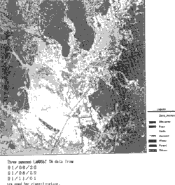
Figure 1: Vegetation map of Kushiro Mire obtained from three seasons LANDSAT TM data.
- Relation between vegetation categories and SAR image
densities
For each vegetation categories SAR image densities fromJERS-1 and ERS-1 were extracted and their image density distributions were compared. There were no distinctive differences between the image density distributions for each vegetation categories except the difference between the forested areas and paddy fields and between the vegetated areas and the residential areas. And also there was no clear and stable relations between the single SAR image densities and the vegetation types and conditions in both of JERS-1 SAR and ERS-1 SAR data.
- Difference between JERS-1SAR and ERS-1 SAR data
Principal Component Analysis (PCA) was applied to the two band images of JERS-1 SAR image and a ERS-1 SAR image from the same season, and the difference component (the second Principal Component was examined to see the difference between them. It shows clear difference, however, at the same time it depends on the seasons and conditions and there is no clear relations between the vegetation types and the differences.
PCA was also applied to the combined set of SAR image from different season for JERS-1 and ERS-1. Figure 2 shows the PCA image for three seasons SAR images from JERS-1 SAR and ERS-1 SAR at Kushiro Mire. The first, second and third components of PCA are assigned to the red, green and blue color respectively. The results shows the multi-seasonal SAR data clearly reflect the vegetation distribution and indicates the possibility of applying multi-seasonal SAR data to vegetation classification. Figure 3 (a) and (b) demonstrate the PCA images for individual three seasons JERS-1 SAR and ERS-1 SAR data respectively, and it clearly shows that the PCA image for JERS-1 SAR has the more distinctive relation with the vegetation types than that for ERS-1 SAR.
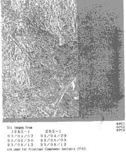
Figure 2: PCA image of three seasons JERS-1 and ERS-1 SAR images (6bands).
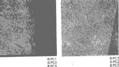
Figure 3: PCA image for three seasons SAR data. (a) JERS-1 SAR, (b) ERS-1 SAR.
3. Vegetation Classification using SAR images
- Classification with statistical analysis and texture
analysis
Conventional statistical classification scheme and texture between L-bank SAR and C-bank SAR in vegetation ERS-1 SAR data to investigate the difference between L-band SAR and C-bank SAR in vegetation classification. First, maximum likelihood classification (MLC) was applied to the registered two band images of JERS-1 and ERS-1 SAR (Fig. 4 (a)). Texture analysis (TA) based on the co-occurrence matrix was also applied to both of the JERS1 SAR and the ERS-1 SAR data, and to the combined two bands images of JERS-1 SAR and ERS-1 SAR data (Fig. 4 (b)) (2). The result from TA shows less noisy classification than that from MLC, however, both of them show the noisy classification than LANDSAT TM based classification due to the speckle noise of SAR data.
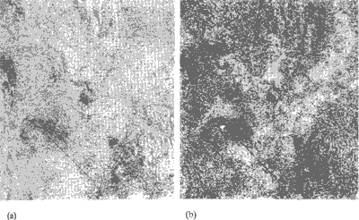
Figure 4: Vegetation classification map of Kushiro Mire obtained from of two band images of JERS-1 and ERS-1 SAR data from one season. (a) Maximum likelihood classification. (b) Texture analysis by co-occurrence matrix.
- Comparison of vegetation category separability between ERS-1 SAR and
JERS-1 SAR
Further, using the co-occurrence texture features (3). The separability between each vegetation categories was compared between JERS-1 SAR and ERS-1 SAR to investigate the difference in the classification efficiency between them. As a separability index Jeffrey-Matsushita distance (J-M distance) in texture feature domain among different vegetation categories were calculated with respect to different textures combination. Figure 5. shows the J-M distance increase curve for JERS-1 SAR and ERS-1 SAR data with respect to the increase of the number of texture features in the classification. Mean values and the minimum values of the J-M distances, JERS-1 SAR data shows the higher separability index than ERS-1 data, and indicates higher efficiency in vegetation classification than ERS-1 data.
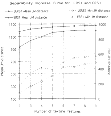
Figure 5: Comparison of separability index based on texture features of vegetation categories between JERS-1 SAR and EERS-1 with respect to the number of texture features.
- Vegetation classification with multi-seasonal SAR images
JERS-1 and ERS-1 multi-seasonal SAR images were also used for the vegetation classification and to the measurement of other land surface conditions including soil moisture or water content. Vegetation classification using three seasons SAR imageries from spring, summer and autumn shows that SAR data, in particular L-bank SAR (JERS SAR), may reflect not only vegetation conditions but also surface water conditions under vegetation. The result of the landcover classification of Kushiro Mire with maximum likelihood classification are shown in Fig. 6. Figure 6 (a) and (b)shows the vegetation map produced by JERS-1 SAR images and by ERS-1 SAR images respectively.
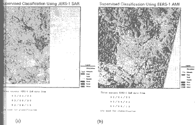
Figure 6: Maximum likelihood classification of three seasons SAR images. (a) JERS-1 SAR, (b) ERS-1 SAR images.
4. Conclusions
The study investigated the possibility of applying the SAR data to vegetation classification. In particular, wetland vegetation was focused as a case study. The results are summarized as follows
- It is difficult to extract effective information on the vegetation types and the conditions from a single season SAR data.
- Combination of multi-seasonal SAR data is efficient for vegetation classification
- JERS-1 SAR (L-band) data is more effective than ERS-1 SAR (C-band) data in vegetation classification.
Acknowledgment
The study was partially conducted based on the Special Co-ordination Funds by Science and Technology Agency of Japan, and also partially conducted as a JERS-1 RA program with NASDA on wetland monitoring. We are grateful to Mr. T. Moriyama of NASDA for his kind support for the joint research
References
- Federal Geographic Data Committee (1992) : Application of Satellite data for mapping and monitoring wetlands- fact finding report. Wetland Subcommittee. U.S. Fish and Wildlife Service.
- Yoshiki Yamagata and Yoshifumi Yasuoka (1993) : Classification of Wetland Vegetation by Texture Analysis Methods Using ERS-1 and JERS-1 Images. Proceedings of IGARSS; 93, pp 1614-1616.
- R.M. Haralick (1973) : Textural features for image classification. IEEE Trans., vol. SMC-3 Nov., pp610-621.