| GISdevelopment.net ---> AARS ---> ACRS 1995 ---> Digital image Processing |
Verification of Atmospheric
Correction for AVH|RR data by Radiometric Simulation Software 6S
Takayuki*, Shoji
Takeuchi**, Koji Kajiwara* and Ryutaro Tateishi*
*Center for Environmental Remote Sensing (CEReS), Chiba University, Japan
1-33 Yayoi-cho Inage-ku, Chiba 263 Japan
**Remote Sensing Technology Center of Japan (Restec)
1-9-9, Roppongi, Minato-Ku, Tokyo 106 Japan
Abstract *Center for Environmental Remote Sensing (CEReS), Chiba University, Japan
1-33 Yayoi-cho Inage-ku, Chiba 263 Japan
**Remote Sensing Technology Center of Japan (Restec)
1-9-9, Roppongi, Minato-Ku, Tokyo 106 Japan
Remotely sensed data is affected by absorption and scattering of the atmosphere. Second Simulation of the Satellite Signal in the Solar Spectrum(6S) is software to simulate these effect with many parameters such as geometric condition, concentration of atmosphere, component of aerosols, etc. Through the 6S is used for atmosphere correction, recently. However , there is no verify the effectiveness of 6S for atmosphere correction using AVHRR data with different geometric conditions.
Introduction
Remote sensor, such as MSS,TM and AVHRR measure radiance reflected from the earth surface at different wavelengths. Reflectance data is used for many applications, for example classification, change detections and so on. However radiance is affected by various factors. If accurate data is required, these effects must be removed from radiance.
These calibration and correction are as follows.
- Preflight calibiration
- Calibiration considering the sensor degradation
- Solar zenith angle correction
- atmospheric correction
If there is no atmosphere on the earth, radiance which reflected the surface is not affected. But in the actual case, the signal is perturbed by the presence of atmosphere on the path sun-target-sensor. Only a fraction of the photons coming from the target reaches the satellite sensor, typically 80% at 850nm and 50% at 450nm, so that the target seems less reflecting(6S User Guide, 1994). These effectives constitute to processes, absorption and scattering. Absorption caused by only O3.H2O,O2,CO2,CH4 and N2O. Scattering caused by dust like, oceanic, water soluble and soot component. These compositions and concentrations changes on account of the time and the location. And these data are not available. Therefore, it is impossible to perform atmospheric corrections using atmospheric data. Therefore, atmospheric data must be assumed. 6s is radiometric simulation software which used for atmospheric corrections recently. However the effectiveness of the atmospheric corrections has not been verified. In this study, atmospheric correction was performed by 6S for multi-temporal AVHRR data and verified effectiveness of 6S for atmospheric corrections
2.Radiometric simulation software 6S
6S is radiometric simulation software presented in 1994. This program is initially developed as 5s in 1984 and is used for radiometric simulation with combination of various parameters as follows
- apparent reflectance
- effectiveness from absorption
- effectiveness from scattering etc.
- Geometric condition (Type of sensor, day , month, latitude, longitude)
- Concentration of H2O and O3 in atmosphere
- component of aerosols
- wavelength of observation
- Height of Target
- Land cover type and reflectance of target etc.
3. AVHRR data and simulation by 6S
The used AVHRR data are three multi-temporal AVHRR data sets which have different geometric conditions and difference time within one week during which the surface can be assumed not to change. The AVHRR data is in Indo-china peninsula of dates: 6/Feb(b9303708) and 12/Feb(b9304409) in 1993. The data are the same one used in Reference No.2. The land cover classes of the samples were forest, agriculture land and bare soil . Solar zenith angle, Azimuth angle, Satellite zenith angle , Ch.1 reflectance and Ch. 2 reflectance for 16 selected areas are shown in Fig.1 . Values in Fig. 1 is the average of 5x5 pixels of 16 areas . Each parameter in 6S is selected as Table 1 .
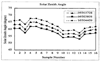
Figure 1(a) : Solar zenith angle for 16 points
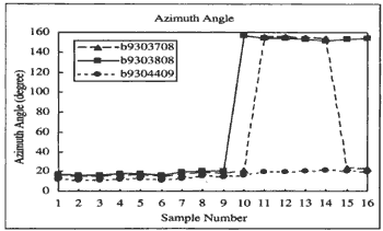
Figure 1(b) : Azimuth angle
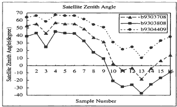
Figure 1(c) : Satellite zenith angle
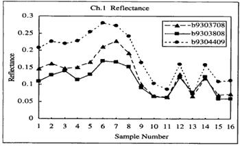
Figure 1(d) : Ch.1 reflectance
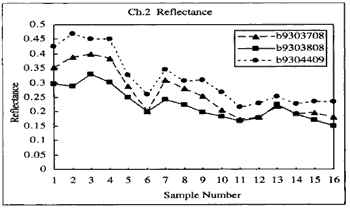
Figure 1(e) : Ch.2 reflectance
The input of 6S simulation in this study is surface reflectance which is an assumed true reflectance of the surface the output is apparent reflectance corresponds to AVHRR data . By changing varieous value of true reflectance , different surface reflectance are derived . The input surface reflectance which results in the closest apparent reflectance to the AVH RR data of a certain pixel is a corrected AVHRR Data
| Parameter | Values |
| IGEOM (Geometric condition) | value of each sample points |
| IDATM (Atmospheric concentration) | Tropical |
| IAER (Aerosols Component) | Continental |
| V (Visibility) | Optical Thickness 0.5 in 550nm (Visibility 8.49k) |
| IWAVE (Wavelength) | NOAA 11 AVHRR Ch. 1 and Ch. 2 |
| IHOMO (Land Cover Type of Target) | Homogeneous and Change Reflectance |
4 Result
the result graphs of atmospheric correction are shown in fig . 2 which is the case is the case for ch . 2 If atmospheric effect by the difference of geometric conditions for three different date,s image is removed, three curves in fig .2 should be closer than of fig .1(e) . however curves of fig . 2 have almost same different as fig .1 (e). in the case of ch . 1 no result was derived decayse ever input surface reflectance of 0 . 0 gives higher surface reflectance than AVHRR data .
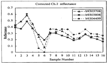
Figure 2: Ch.2 reflectance after atmospheric correction
5 Discussion
The causes of the the above results can be assumed as follows .
- Parameters may not be appropriate. The parameters inputed inthis study are prepared as standard condition in tropcal and continenttal area in 6s . however , there is possibility that input parameter are not appropriate in this data . in order to examine the effected by input parameters simulation was performed with visibility parameter changing from infinity to 3.57 km . however , the difference is less than 0.06. This means that visibility parameter does not affect the result of simulation much in this study. If the parameter which affect those simulation exists, it is another parameter expect visibility.
- Sample points may not be appropriate. Sample points must be selected from area with homogeneous and no cloud . However thin cloud , un-homogeneous or changed surface in a short time might be selected.
- Simulation by 6S may contain some fundamental problems .
Authors plan to simulate with AVHRR data in order to make clear the above problem . and it is necessary to use ground truth reflectance data. If it is not possible satellite data in a desert or a runway in airport , where the surface reflectance is stable , must be used for verification.
Reference
- 6S User Guide Version 0, April 18,1994
- Shoji Takeuchi and Yasushi Mitomi, Effects of sensor Degradation and solar-sensor Geometry on land Cover Monitoring Using NOAA/AVHRR data, Proceedings of the International Symposium on vegetation monitoring 115-122, August 29-31, 1995,Chiba , Japan