| GISdevelopment.net ---> AARS ---> ACRS 1995 ---> Agriculture/Soil |
Assesment of Era Sar Data for
Tropical Acricultural Crop Monitoring
J. Aschbacher1,
A Pongsrihadulchai2, S. Karchanasutham2, D.R.
Paudyal3, E. Nezry1,
M.Wooding4
1European Commission, Joint Research Centre (JRC),
TP 441, I-21020 Ispra (VA), Italy
Tel : +39-332-78- 5425, Fax : +39-332-78-5461;
E-mail : Josef.aschbacher@jrc.i
2OAE, Phaholyothin Road, KU Campus, Bangkok 10900, Thailand
3Forestry Building, Indooroopilly, Brisbane QLD 4068, Australia
4RSAC, Mansfield Park, Medstead, Alton, Hamsphire GU34 PZ, UK
Abstract 1European Commission, Joint Research Centre (JRC),
TP 441, I-21020 Ispra (VA), Italy
Tel : +39-332-78- 5425, Fax : +39-332-78-5461;
E-mail : Josef.aschbacher@jrc.i
2OAE, Phaholyothin Road, KU Campus, Bangkok 10900, Thailand
3Forestry Building, Indooroopilly, Brisbane QLD 4068, Australia
4RSAC, Mansfield Park, Medstead, Alton, Hamsphire GU34 PZ, UK
The current study discusses the potential of radar remote sensing for tropical agriculture crop monitoring. Theoretical considerations about radar backscattering of agriculture crops are presented and discusses. The theoretical considerations are complemented by actual case studies carried on different agricultural crops such as rice, sugarcane, rubber plantations, and other crops. Temporal radar signatures are presented for different tropical crop types and compared with those of temperate crops. The presentation also compares different approaches regarding the analysis of SAR data, such as field based versus pixel based approaches, or data processing methods including speckle filtering, texture analysis and segmentation. Results obtained via different mean are compared and discussed.
Among the case studies particular emphasis is given to the monitoring of rice using radar data. It can be shown that, for example, the use of radar data allows to retrieve rice area as well as accurate information about the plant's growth from ERS SAR data.
1. Introduction
The 1990's have seen major developments in the use of satellite remote sensing for agricultural monitoring and production forecasting. The `Monitoring Agriculture by Remote Sensing' (MARS) project of the European Union, for example, is a major initiative using satellite-based techniques for the collection of crop statistical information. Also in tropical countries the use of remote sensing has become more important in recent years. At regional and local levels, there is increasing use of remote sensing as a source of information on changes in agricultural cropping and for production forecasting.
Agricultural applications of remote sensing are time critical. The accurate identification of crop types depends on the availability of images acquired within specific time windows through the crop growing season, when there are marked differences in the appearance of particular crop types on remote sensing images. Equally, there is a need for images acquired at particular key times or yield prediction purposes. Despite the progress which has been made towards operational applications, experience shows that high Despite the progress which has been towards to wards operational applications, experience shows that high resolution visible and infra-red satellite sensors cannot always provide the desired information due to constraints related to cloud cover and revisit schedules. *the work presented in this paper was carried out within the farm work of the `EC-ASEAN ERS-1 Radar remote sensing Project (ALA/ASN//28)'. The project is funded by the European Commission (EC) with support from the European Space Agency (ESA) and the Association of South-East Asian Nations (ASEAN). In addition, the current project is supported by the Office of Agricultural Statistics & Economics (OAE) of the Thai Ministry of Agriculture and the National Research Council of Thailand (NRCT).
Radar satellites like ERS-1 and ERS-1 overcome the problem of cloud cover. Synthetic Aperture Radar (SAR) systems transmit microwave energy down to the earth's surface and record the variable strength and phase of the `backscattered' return signal. Images are obtained independently of cloud coverage of daylight conditions and contain information on roughness and dielectric properties of the surface. Radar is sensitive to the structure and moisture content of vegetation canopies, and to soil roughness and moisture content.
The use of radar remote sensing for tropical agricultural monitoring
There is a great variety of tropical agricultural crops, examples of which are rice, sugarcane, maize, tapioca, coffee, tea, rubber and fruit tree plantations. However, in the paper emphasis is put on rice, being the crop with the largest economic and social importance for many countries. The example of rice monitoring and mapping also highlights in an exemplary manner the potential of radar remote sensing and is applicable in principle to many other crops. A short discussion on agricultural plantations and other agricultural crops (e.g. sugar cane, maize complements the assessment of radar for rice mapping and monitoring.
2. Comparison of Different Data Analysis Techeniques
Paudyal (1994) has investigated also other land cover categories at the Thailand study area, where, apart from rice fields, also large plots of sugarcane are present, intermixed with bushes, intermixed with bushes, shrubs, water and urban areas.
Knowledge based classification methods, or unfiltered versus speckle filtered and/or texture analysesd images. The latter methods was developed making use of pre-assumptions about the rice growth cycle based on temporal profiles of s [dB]. These results were compared with a Landsat TM image and ground measurements for accuracy assessment. A tabular overview of the classification results is given in Table 1.
| No. | Classification method | Input data | Overall Accuracy (%) | Rice Accuracy (%) | Sugarcane Accuracy (%) |
| 1. | Max. likelihood | Unfiltered | 65.3 | 58.4 | 70.8 |
| 2. | Max. likelihood | MAP speckle filtered | 69.9 | 72.4 | 73.0 |
| 3. | Max. likelihood | Lee speckle filtered (2 iterations) | 75.2 | 78.0 | 87.5 |
| 4. | Max. likelihood | Texture (angular second moment plus contrast) | 69.9 | 63.9 | 73.1 |
| 5. | Max. likelihood | Texture(ASM+ IDM) plus speckle filtered (Lee) | 79.7 | 77.8 | 87.7 |
| 6. | knowledge based segmentation | MAP filtered | 79.9 | 91.8 | 71.0 |
The results of the supervised classification based on five dates (MAP-filtered, Nezry et al., 1991) has given an overall classification accuracy of 69.9%, while the knowledge-based method gave 79.9%, which is a clear improvement. The same accuracy was obtained when combining speckle and texture analysed images as input for a maximum likelihood classification. As an example, the classification accuracy matrix was extracted for the agricultural crops rice and sugarcane only, and compared with the overall accuracy including all six land cover categories. It is worth noting that the accuracy of rice alone has increased from72.4% for the MAP-filtered classification to 91.8% for the knowledge-based segmentation method. For sugarcane, however, the combined speckle filtered and texture analysed image are the best source for further classification. The accuracy reaches 87.7% in this case.
As can be seen from Table 1 there is no general method superior to another if all land-use categories are considered. However, the more sophisticated methods combine speckle filtered and texture analysed data are clearly superior to a classification using only unfiltered or speckle filtered images. The knowledge-based method was adapted to discriminate rice fields from other categories and performs best for the category of rice. A further description of the methodology can be obtained from Paudyal (1994).
3. Rice Crop Mapping and Monitoring
Study area and Data Basis
A study area of approximately 10x10 Km size was selected in West Thailand (99.5 deg. E, 1.0 deg N). The rice growing area is irrigated, flat, homogeneously, and has large individual fields of at least one hectare size, Multi-temporal ERS-1 SAR data were available at eight acquisition dates, namely 22-Nov-91, 7-Oct-92, 24-Feb-93, 11-Jun-93, 20Aug-93, 29-Oct-93 and 3-Dec-93. Within the whole area ten sample areas of approximately ten hectares each were selected fir detailed backscattering studies of rice field. Extensive ground measurements were taken in parallel to ERS-1 data acquisitions during the main growth period Aug-Dec 1993. Plant height, plant moisture content, plant density, number and size of leaves, stalk diameters, height of standing water were measured, together with more general observations regarding the state of the water/soil surface, state of plants, and a Spot panchromatic image.
Rice plant growth and Radar signature of rice-fields
Rice has three major growth phases, the vegetative, reproductive and ripening phase. In the selected study area the growth cycle lasts 120 days, and two harvests per year are common. The main growth period lasts from August to December, a second crop grows from April to July.
In ERS SAR images rice fields appear dark during the vegetative phase when the field are flooded. During the reproductive phase radar backscattering increases and reaches a maximum in the early ripening phase. This maximum may plausibly be attributed to multiple radar reflections between vertical plant structures and the horizontal water surface at a growth stage when penetration to the surface is still possible. Later, during the ripening phase, the scattering from the volume of the canopy increases but penetration to the water or soil surface decreases leading to a slight darkening in the radar image.
Result-Rice area mapping
Rice acreage can be retrieved from multi-temporal radar imagery making use of the unique backscattering signature of rice fields which is significantly different from that of any other land-cover. Fig. 1 shows a multi-temporal image taken 6-Jun-93, 29-Oct-93, where the rice growing area appears in dark grey and can easily be discriminated from other land covers.
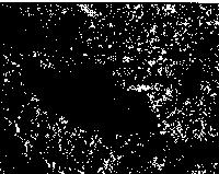
Figure 1 Multi-temporal ERS-1 SAR image of Kanchanaburi, W-Thailand. Rice fields (dark, centre) are clearly discriminated from other land-use categories.
A simple, pixel-based maximum likelihood classification was carried out, based on four Gamma MAP speckle filtered radar images (6-Jun-93, 20-Aug-93, 3-Dec-93). The result of the classification is shown in Fig. 2. The classification accuracy for rice versus other land-use classes is 89% (Aschbacher et al., 1995; Aschbacher, 1995).
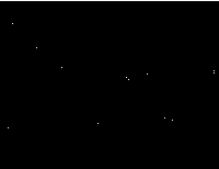
Figure 2: Rice area based on four ERS - 1 SAR data acquisitions (6-Jun-93, 20-Aug-93, 29-Oct-93, 3-Dec-93). Grey scale: rice (dark), water (bright), other land-use classes (black).
Result-Rice Crop monitoring
Radar sensors have the potential to monitor rice plant growth regardless of cloud cover. An examples of temporal radar signatures compared with rice plant height is shown in Fig. 3. which shows a correlation between rice plant height and radar backscattering so [dB]. The correlation coefficient is r = 0.77. Also, a correlation between measured yield and s0 values was carried out for the pre-harvest date 3-Dec-93. The fields were harvested 2-4 days later. The corresponding correlation is shown in Fig. 4. The correlation coefficient is r = 0.87. It should be noted, however, that the sensitivity of backscattering is mainly related to the plant's total biomass, its moisture content and the plant's geometry, and therefore grain yield may only be an indirect effect of these parameters. Nevertheless, the result is interesting and worth further investigations.

Figure 3: Corelation between plant height and radar backscattering coefficient, including data from 29-Oct-93 & 3-Dec-93.
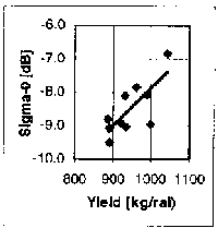
Figure 4: Correlation between measured rice yield and radar backscattering coefficient, for the pre-harvest date 3-Dec-93.
Among all the agricultural crops the use of radar remote sensing is probably most promising for rice crops due to its significant temporal backscattering. The dynamic range of so [dB] is the largest among all agricultural crops, ranging from approx. - 16 dB during the flooded and early growing stage to approx. -8 dB during the pre-harvest stage. The selection of appropriate acquisition times is crucial for mapping purpose. As regards yield estimates or parameters that lead to yield estimates there is a clear correlation between radar backscattering signals and plant height, which allows to determine the approximate age of rice plants and thus a prediction of the approximate harvesting time. The results available from several case studies allow to draw the following conclusions as regards the use of ERS-1 SAR data for rice mapping and monitoring (Achbacher et al., 1995, Kurosu et al., 1993 Le Toan, 1989) :
- Multi-temporal ERS-1 SAR data can be used in an operational or quasi operational mode for mapping or rice fields, both for irrigated and rain-fed fields.
- Multi-temporal ERS-1 SAR data can be used in pre-operational manner for the retrieval of yield-related parameters.
- A priori knowledge about the rice crop calendar and growing practices as well as parallel in-situ measurements largely facilitate the interpretation of radar images. However, reliable results can be obtained also without or with a very limited set of in-situ measurements. This is of particular interest in view of large scale operational rice monitoring systems.
- For mapping purposes at least three dates should be available during the growing cycle. The optimum acquistion times are during the early flooded stage, the flowering stage and shortly before harvest. An additional post-harvest image is useful if the time of rice harvest if different from that of other agricultural crops on the same scene.
- for the retrievel of yield related parameters the use of 4-8 acquistions during the growth cycle is recommended. The image dates should be equally spread throughout the growth period. As acquisition shortly before harvest is mandatory.
- Multi-temporal ERS-1 SAR data can be used to determine field management practices, such as the timing of irrigation, time of harvest, method of water supply (irrigated or rain-fed), and the length of the growth cycle. This information can be retrieved largely without in-situ measurements.
- As regards the optimum analysis technique applied to radar imagery for rice mapping it is recommended to speckle filter the images and apply texture and/or segmentation based algorithms before classifying the images. Depending on the characteristics of the respective scene special measures may have to be applied if field management differs within one scene.
- If an operational rice monitoring system is developed it is strongly recommended to include multi-temporal radar imagery as a prime data source.
- Aschbacher, J. A. Pongsrihadulchai, S. Karnchanasutham, C. Rodprom,D.R. Paudyal, T. Le Toan; 1995 : "Assessment of ERS-1 SAR data for rice crop mapping and monitoring"; Proc. IGARSS `95', Firenze/Italy, pp. 2183-2185.
- J Aschbacher, "Tropical Crops", chapter 6 in ESASP-xxx (The potential of ERS satellite radar in agriculture, Ed. M. Wooding et al.), ESA Publ. Div. ESTEC Biirdwuhjm Ictiver 1995 (in press).
- T. Kurosu, T. Sutz, M. Fujita, K.Chiba and T. Moriya, "Rice crop monitoring with ERS-1 SAR : A first year result", Proc. 2nd ERS-1 Symp., 11-14 Oct. 1993, pp. 97-101.
- T. Le Toan, H. Laur and E. Mougin, "Multi-temporal and dual-polarisation observations of agricultural vegetation covers by X-band SAR images", IEEE Trans. Geosc. Rem. Sens., Vol. 27, No. 6, 1989, pp. 709-718.
- E. Nezry, A.. Lopez and R. Touzi, "Detectionof structural textural features for SAR image tropical agriculture", Doctoral thesis (unpublished), Asian Institute of Technology, Bangkok, Thailand, 1994.
The work was carried out within the "EC-ASEAN ERS-1 Project (ALA/ASN/91/28)", which is funded by the EC, ECA and ASEAN (Association of South East Asian Nations). Additional Support was provided by the Office of Agricultural Statistics & Economics (OAE) and the National Research Council of Thailand (NRCT). The author wishes also to thank their colleagues who provided valuable input to this paper, in particular Mme T. Le Toan (CESBIO Toulouse) and J-P Malingreau (EC JRCMTV)