| GISdevelopment.net ---> AARS ---> ACRS 1995 ---> Agriculture/Soil |
Utilization Ofstatellite
Remotely Sensed Data As An Information Source for a GIS In Agricultural
Resource Management
Farhad
Jenabfer
Remote sensing / GIS division,
agricultural statistic & information department (ASID)
Ministry of agriculture 144155 Tehran ,Iran
Tel : (+95) 21 61 22102 fax (98) 21 650377
Abstract Remote sensing / GIS division,
agricultural statistic & information department (ASID)
Ministry of agriculture 144155 Tehran ,Iran
Tel : (+95) 21 61 22102 fax (98) 21 650377
Landuse/Landcover data is one of the most important data layer in any Geographic information system for agriculture resource management . the lack of Recent ,reliable and up-to- date data for prepration of Landuse /Landcover maps has made satellite imagery ,the only practical source of up-to-date data for such studies .The study area located in north of Iran ,Gilan province was selected because of it variable vegetation and economic. Three different seasonal TM data sets acquired between1991-1994, were utilized in the , prepration of Landuse/Landcover maps which comprised seven major classes (24sub-classes) and four mixed classes. In addition some specific crops like tea and olive were also mapped. The information derived from these maps together with other data such as Topography , Transportation network, International and provincial boundaries , etc were compiled for use in the envisaged GIS that will eventually have more than 25 different information layers.
Introduction
Geographical information systems (GIS) provide an essential technology for concidering the interaction between spatial distribution of resources . GIS are now established as a common feature of both management and research in areas such as ; natural resource inventory ;mineral exploration ; primary production estimation and natural hazard evolution .
Probably the biggest problem in a geographic information system is the base maps that the software uses to perform its analysis. The deficiency of these maps or updated once is the main reason for using remotely sensed data as a consistent source of information. The results of visual image interpretation and digital processing can now fulfill a number of functions within a GIS.
This paper describes the methods used to create an agricultural GIS and problems encountered in this way
Studyarea
The area selected this project is Gilan Province, located in north of Iran, limited between long. 48 ° 35'-50°, 3' E and lat. 36'-38°, 30 N, with the total area about 15000 Km2
The role of this province national agriculture is the main reason for its selection. More than a quarter of the Rice production and about the whole production of Tea and Olive in the country obtain from this percent of this area is covered by dense, natural forests that has a significant role in wood industry.
Datasources
The use of image data to derive geographical information has long been established in the form of both topographic and thematic maps produced by the interpretation of stereoscopic aerial photographs. The sources of visual image interpretation serves to emphasize the potential serves to emphasize the potential for further improving the accuracy of digital image analysis, by including information other than spectral data (Haralick 1979). Especially in the extraction of LU/LC information for the compilation of thematic maps, visual interpretation has set a formidable precedent inters of the number of distinguishable classes. The application of satellite remote sensing to natural resource mapping has therefore often encountered resistance where there has been a history of mapping by photo-interpretation (Rivard 1990). This is especially so when land cover information is stored in GIS and then used to derive thematic products in combination with a number of other themes that are often of layer or unspecified accuracy.
Despite the legacy of photo-interpretation, remote data from satellite (especially Land TM and SPOT) have nonetheless become well established as a primary source of information in many applications related to natural resources. The inherently digital format of the data, the frequency of routine coverage of relative ease with which near-nadir imagery an e georeferenced all offer very significant advantages over photographic coverages of the same area (Konecny 179).
The Landsat satellite series which began in the 1970's is probably the most well known digital imagery gathering system. The Thematic Mapper (TM ) is a popular data source and consists of seven bands or spectral ranges. The seven bands are blue, green, red in the visible spectrum, a near infra-red, two mid range infra-reds and a thermal infra-red.
The typical TM scene covers185 X 170 km of the earth surface and is repeated every19 days. The data is organized into a matrix with each pixel covering an area of 30 by 30 meters. In each of the seven bands each pixel contains one data value representing the spectral intensity reflected from relative surface on the earth.
In this project 3 different seasonal TM data sets, acquired between 1991 to 94 and a CCT (1993) containing the whole coverage of the study area were selected to create LU/LC maps of the province.
Deriving Base Maps from Image Data
A very important application of high spatial resolution satellite data is their use as abase map, especially in those application where no other reliable data is available (Gastella-Etchegorrg 1989).
Digital satellite data have a number of advantages over conventional photo-grametric methods in terms of providing cartographic information (Swann 1988). Satellites provide regular, repeat coverage, and the required data can often be simply extracted from an archive. The data are inherently digital, and so can be used directly in digital cartographic production systems. Data costs are often much less than for an equivalent aerial photographic coverage, and the cost of establishing ground control is very much less when using near-nadir satellite imagery.
Both visual interpretation and digital image processing software's were used in the project. The below stages have been concerned;
- Visual image interpretation of TM quadrants of three different dates, covering whole province according to the legend approved by Project Manager; containing seven major classes (Forests, Cultivated area, Ranges, Wetlands, Bare lands, Water resources, Constructed area) divided into 24 subclasses and four mixed classes. In addition, another features such as Roads, Rivers, International and Provincial boundaries were mapped.
- Digital image processing
- Mosaicking of TM quadrants, covering the whole province and masking the interested area
- Image rectification, geometric correction of the mosaicked image, using 1.50,000 scale topomaps and ground control points (GCP) selection (image/map registration). Geometric correction of an image is necessary because in GIS applications the reference coordinate system is the foundation of the database. Without a coordinate system coverages could not be accurately overlayed compared or used for analysis. Once a coordinate system has been selected ground control points could be selected.
- Unsupervised classification of masked area to identify main agricultural regions and obtain the auxiliary information to be used in the further stages.
- Ground checking of unsupervised classification results to select the best areas for training sites.
- Concerning to the noticeable forest areas in the mentioned province, these areas were masked out to decrease the disk space and data processing time.
- Pre-precessing, enhancement and supervised classification of relative images. It worth to mention to raise the spectral separability, different kinds of data manipulation such as signature separability assessment, principal component analysis, feltering and the like were applied.
- Filed sample checking, using GPS facilities to determine the reliability of the classification and correct possible errors by statistical methods. In this step, the constant geodethic points were used as base stations for differential positioning with GPS.
- Plotting a hardcopy of classified image after all corrections.
Creation of the Geographic Information System
Two types of analyses that could use satellite imagery to create GIS coverages are 1 when polygon boundaries are defined by another process but attributes are determined from the imager. It is important to remember that the satellite data will need to be converted into an acceptable format by the Geographic Information System.
Satellite data generally have a raster data structure, which has considerable advantages during image processing operations. In contrast, the structure of data commonly used to represent geographical phenomena are vector based. At present, the majority of GIS use a vector data structure. Raster to vector data conversion is an essential step that can cause many problems to be resolved before digital image data relating to natural resources can be incorporated automatically into GIS. This is the generalization of classified digital image. Data to the mapping scales commonly encountered of classified digital image data to the mapping scales commonly encountered in GIS (Ehlers at et al. 1989). The remotely sensed data that offer the most benefits for natural resource mapping currently come from the Landsat TM or SPOT satellites, whose sensors have ground resolutions of 30 to 20 meter, respectively. For the purpose of inclusion in GIS, these image data must be generalized to homogeneous polygons that cover an area, for example, of 100 or more pixel data. The generalization is well defined when each of the features being mapped can be uniquely classified, with the classified image consisting of relatively large domain-areas of the image which comprise a single class, with the possible exception of a relatively few, isolated, pixels from other classes. Under these circumstances, an edge detection filter can be applied to define domain boundaries, a median or contextual filter used to generalize the data (e.g. Both et al. 1989) and the intersection of the edge and median filtered data used to generate the general image prior to raster-to-vector conversion.
The operational procedure to create the GIS is outlined below;
Input spatial data
- Digitizing basic geographic data of the province, using 1 : 2500,000 scale topomaps. 1 : 50,000 topomaps.
- Digitizing contour lines layer from 1 : 50,000 topomaps.
- Scanning Landuse/Landcover maps derived from satellite data, rester-to-vector data conversion, create LU/LC data layers.
- Editing and create topology of the data, gathered in the previous steps.
- Building the geographic database, input attribute data of each geographic feature and any relative information.
- Data manipulation, projection, transformation, map-joining, edge-matching.
At this stage, the satellite image becomes useful to the GIS user as it is geographically referenced to other data sets. The primary application of the imagery is for base map generation and revision. This is carried out within range of feature coding of the digitized data. Completely new vector data files maybe created or existing maps edited. A classified image can be used directly in raster overlay analysis, or the polygon boundaries can be victories and used in vector polygon analysis.
In view of the fact that this GIS was designed to be used as a tool in agricultural planning programs, by adding the information of soil, climate, geomorphology, social-economy, etc, it would be a very efficient and powerful database for the future plans of the Ministry.
The use of satellite data in the field of Geographic Information Systems is efficiently an important alternative in the creation of GIS coverages. In the past, three problem have prevented the use of satellite imagery within a GIS. Firstly, not enough information was visible in the data to warrant its use; secondly specialized and expensive hardware was generally needed to process the data and thirdly, software was not available to analyses raster and vector together.
But the satellite imagery now, affords the user greater flexibility, in determining scale, time of analysis, level of detail, and most importantly what information the coverage should contain. There are some standard digital cartographic products but for many other generating a coverage from satellite data maybe the only alternative.
Acknowledgment
The author would like to thank the endless assistance of Mrs. E. Madanian (Senior Expert of GIS, in various steps of GIS creation.
References
- S. Khan & R. Toleti, "Remote Sensing and Geographic Information System for environment and pollution studies" Proc., International Geosciences and Remote Sensing Symposium, Tokyo, 1993
- C.M. Trotter, "Remotely-sensed data as an information source for Geographical information system in natural resources management : a review", International Jour. Of Geographical Information Systems, Vol. 2, 1991
- G. Csornai, O. Dalia, J Farkafalvyand G. Nadar, "Crop inventory studies using Landsat data one large area of Hungary", Application of Remote Sensing in agriculture, Landon, 1990.
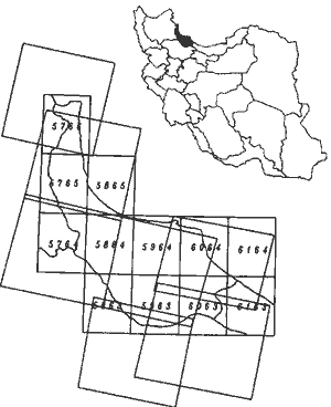
Location of the Study area in North of Iron Gilan Province
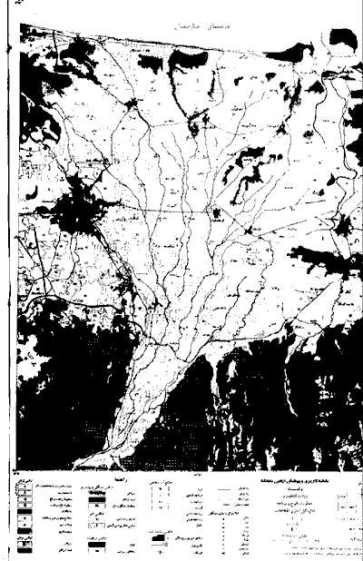
A Scaled seet of Landuse/Landcovi maps; derived from satellite data