| GISdevelopment.net ---> AARS ---> ACRS 1995 ---> Agriculture/Soil |
Multi- Seasonal Analysis of
SAR Data for Agriculture
Genya Saito, Nobuyuki Mino
and Akira Hirano
Remote Sensing Laboratory,
National Institute of Agro-Environmental Sciences
Kannondai 3-1-1, Tsukuba, Ibaraki 305, Japan
Fax :+81-298-38-8199
E-mail : mailto:genya%20@niaes.affrc..go.jp, hirano@niaes.affrc.go.jp
Abstract Remote Sensing Laboratory,
National Institute of Agro-Environmental Sciences
Kannondai 3-1-1, Tsukuba, Ibaraki 305, Japan
Fax :+81-298-38-8199
E-mail : mailto:genya%20@niaes.affrc..go.jp, hirano@niaes.affrc.go.jp
Multi-seasonal analyses of SAR data for agriculture were performed using JERS-1(L-band DAR) and ERS-1 (C-band SAR) images at grassland, upland farming field and paddy area in Hokkaido, northern island in Japan.
In konsen-plateau in the north-eastern part of Hokkaido, which is comprised mainly of grassland ,images of JERS-1 data taken in April, June and August looked similar to each other except the spots where land use change occurred. In Tokachi plain, which is comprised mainly of upland farming field the back scattering coefficients of ERS-1 data taken in August are larger than those of April. In the same area. images of JERS-1data taken in June, August and October looked different from each other in agricultural field because of the soil-surface conditions. In Ishikari plain, which is comprised mainly of paddy, the back scattering coefficients of ERS-1 data taken in June when water fills the paddy are smaller than those of August and October when no water is in the paddy.
The JERS-1 microwaves pass through agricultural pants and then scatter at the ground surface, but ERS-I microwaves scatter at agricultural plants. Although we cannot get direct information about agricultural plants using JERS-1 data, we can get useful information about agricultural environment from the data. TheERS-1 SAR can directly measure agricultural crops, but the data include other information such as soil surface conditions and topographical features.
1.Introduction
Many studies on agriculture using remote sensing technique have been performed in Japan since LANDSAT was launched in 1972. these studies were made using optical sensors such as LANDSAT/TM MSS,SPOT/HRV, MOS/MESSR, and NOAA/AVHRR.
In Japan, crop growing period is from May to September, when temperature is relatively high and it rains much. It is very difficult to acquire optical remote sensing data during that time because of the cloud cover. Data acquisition is highly restricted in some tropical rainforest areas.
We use SAR data as the solution to the data acquisition problem, and to get other information concerning object size, form and water contents. Quantitative treatments to multi-temporal data can be performed , because same microwave energy reaches on earth every time when using same SAR instrument while data from optical sensors are greatly influenced by atmospheric conditions, SAR data are believed to be quite independent from atmospheric effects.
ERS-1 and JERS-1 were launched in 1991 and in 1992 respectively, and both satellites have SAR instruments. In Europe and America, there are some experimental analyses concerning agricultural study using SAR DATA (1),(2), whereas in Japan, their is no report on that subject. We made images from SAR data, and they were compared with LANDSAT/TM images, Topographical maps and ground truth data.
2.Mthods
2.1.SAR data
Table 1 shows characteristics of SAR instruments and table 2 shows the list of remote sensing data used in this study.
2.2 Analysis instruments
we used the remote sensing analysis system of National Institute of Agro-Environmental sciences. The system has 5EWS, 3 digitizers, a MT unit, 2 types of scanners, a color hard copy machine and a color electrostatic plotter. The system is installed with ERDAS as a image processing data analysis software and ARC/INFO as a geographic information system software.
2.3 Ground truth data
In Hokkaido district, ground truth surveys were made six times as the cooperative works with Hokkaido National Agricultural Experiment station and konsen Agriculture Experiment station. We used topographical maps of 1/25,000 made by Geographical survey of Japan.
| Wave length | incident angle | polarization | spatial resolution | Swath | |
| JERS-1 | L-band 1.275GHz 23.5cm |
38.5 | HH | 18m looks | 75km |
| ERS-1 | C-band 5.3 GHz 5.66 |
23 | VV | 15m looks | 100km |
3. Results
3.1 konsen-plateau
This area is located in the north -eastern part of Hokkaido. The temperature in this area is low for growing crops and agricultural land use of this area is mostly grass for livestock. JERS-1/SAR and LANDSAT/TM images acquired almost at the same time of years in April, June and August, and they are indicated as photo 1. In LANDSAT IMAGE Acquired in April, bright parts represent grasses and evergreen forests, and dark parts represent urban areas, bare soils and deciduous forests. In LANDSAST images acquired in June and August, bright parts represent forest and grassland, and dark parts represent urban areas , bare soils and just after cutting grassland.
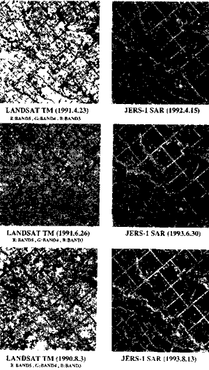
Photo 1. JERS-1/SAR and LSNDSAT/TM images in Konsen-plateau
AS for JERS-1/SAR images, three images of different times are almost same . in these images, bright parts are forests and u]urban area, and dark parts are grasses and bare soil. While it is very difficult to distinguish forests from grasses using SANDSAT/TM data, it is easy to separate the two things using JERS-/SAR.
Using JEERS-1/SAR and KANDSAT/TM data , we can classify grasses, evergreen forests, deciduous forests, urban areas, bare soils and deciduous forests.
We tried to extract agricultural area containing grasses and bare soils in this region using
JERS-1/SAR data. First, we performed speckle noise reduction using filter treatment, and then we picked up agricultural area as low digital number parts by level slice method. From the observation of JERS-1 data, it can be concluded that L-band microwave passes through grass body, and scatters on earth.
Back scattering coefficients in Konsen-plateau are calculated and indicated in fig.1. Forest if the highest, second id urban area, and the lowest is grassland. We can not detect any seasonal changes.
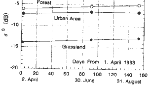
Figure 1 Back Scattering Coefficient of JERS/SAR on Konsen Plateau
| Area name | sensor | Acquisition time |
| Konsen-plateau (Hokkaido) | JERS-1/SAR LANDSAT/TM |
1992/04/15 1993/04/02 1993/06/30 1993/08/31 1992/04/09 1991/04/23 1991/06/26 1990/08/13 |
| Tokachi plain (Hokkaido) | JERS-1/SAR
ERS-1/AMI-IMAGE LANDSAT/TM |
1992/06/01 1992/07/15 1992/08/28 1992/10/23 1992/06/02 1992/08/11 1992/04/09 1987/06/22 |
| Ishikari plain (Hokkaido) | JERS-1/SAR
ERS-1/AMI-IMAGE LANDSAT/TM |
1992/02/04 1992/08/31 1992/05/20 1992/10/14 1992/07/29 1987/06/22 |
3.2.Tokachi plain
This area is located in the eastern part of Hokkaido. The area is mostly comprised of crop field and no paddy. The crops are winter wheat, sugar beet, soy bean, kidney bean, corn potato etc. JERS-1/SAR data were acquired in June, July August and October; ERS-1/SAR data were acquired in June and August.
In four JERS-1/SAR images, we can detect some difference caused by the soil surface change. Distinctive difference between the two WES-1/SAR images can be observed. In early June, most areas appears very dark and small parts very bright, because there are very small crop plants or no crop in the agricultural field. Plowing direction that is perpendicular to that of microwave radiation was recognized as bright line. In August,
Most areas are bright because crops grew large. We can detect the edge of plateau in ERS-1/SAR images easily while it is difficult to do so in LANDSAT/TM image.
3.3 Ishikari plain
This area is located in the central part of Hokkaido. The area is mostly paddy fields, but recently other crops have been planted because of the surplus production of rice. The JERS-1/SAR images were taken in June, August and October and those of ERS-1/SAR Were in May and July.
Back scattering coefficients of paddy, soybean (drained paddy field for upland crop cultivation), winter wheat and urban area were calculated and indicted in Fig.2. Back scattering coefficients of JERS-1/SAR in paddy are almost same in three different times in a year. However, the one in June is little lower than those of others because there is water in paddy in June and there is no water in the end of August and October.
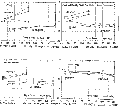
Figure 2 Back Scattering Coefficient on Ishikari Plain
As for back scattering coefficients of ERS-1/SAR in paddy values of July is higher than that of May because of biomass as a whole except one plot. The only exception was caused because of the planting direction. As for back scattering coefficients of JERS-/SAR in winter wheat and soy bean field, there are almost no differences in the value throughout the year and they are constantly low. As for back scattering coefficients of ERS-1/SAR in winter wheat and soy bean field, values of July are higher than those of May because of biomass. For both back scattering coefficients of JERS-1/SAR in urban area, values are equally high in times.
4. Conclusions
The comparison between JERS-1 and ERS-1 SAR images showed that JERS-1/SAR (L-band SAR) microwaves pass through agricultural plants and then scatter at surface while ERS-1 SAR ( C-band SAR ) microwaves scatter at agricultural plants. We cannot get direct information about agricultural plants but we can get useful information about agricultural environment using JERS-1/SAR data. The ERS-1/SAR can directly measure agricultural crops , but the data include many other information about soil surface and topographical condition.
Trees and agricultural crops (including grasses ) show very similar spectral reflectance patterns . By only using data from optical sensors such as LANDSAT/ TM, it is difficult to distinguish one from another. However, by using JERS-1 data, it is easy to distinguish
Them because trees have high back scattering coefficient by volume scattering at trunks and branches while agricultural crops have low back scattering at trunks and branches while agricultural crops have low back scattering coefficient by no volume scattering.
In urban areas, SAR data have high back scattering coefficient. On the other hand, agricultural field , bare soil and water areas have low back scattering coefficient. Using JERS-1 data, we can easily extract agricultural field because of their low back scattering coefficient. We made a distribution map of agricultural field a in konsen area in the north eastern part of Hokkaido using filter treatment of speckle noise reduction in order to extract agricultural field.
A seasonal change can be observed in ERS-1 data between June and August at Tokachi plain Agricultural field shows low back scattering coefficient in June and high value in August. In JERS- 1 data it is difficult to detect the seasonal change in konsen-plateau.
References
- NASA: Synthetic Aperture Radar, Instrument panel Report, vol. IIF, Earth Observing system, 1987 .
- CCRS: Radar Data Development program, Gananoque workshop,1990.