| GISdevelopment.net ---> AARS ---> ACRS 1994 ---> Water Resources |
Water Quality Analysis on the
Chao-Phra-Ya Estuary Using Remote Sensing Data
Hansa Vathananukij
Kasetsart University/RID Thailand
Shunji Murai
Asian Institute of technology/University of Tokyo Thailand/Japan
Suvit Vibulsresth
National Research Council Thailand
Prof Mushiyaka Katsumi, Ass. Prof. Shibasaki Ryosuke, Mr. Hiroaki Kakiuchi
University of Tokyo Japan
Dr. Yoshifumi Yasuoka, Mr. Yoshiki Yamakata
The National Institute for Environment Studies. Japan
Abstract:
Previous analysed research has been concentrated on prominent area of the Chao-Pra-ya estuary; deltaic area have been promoted from agrucultural area to urban one, accentuated several problems on river reach while Chao-Phra-ya river has been only fresh-water resource to this area. Sincedifficultiies in ground investigation costs and heavily boat transportaion have been concerned, tremendous satellite images techniques were intruduced to analyse historically.
Percentage difference, linear-regression analysis, correlation matrix and one-dimension statistical analysis were used to analyse among varios water quality parameters and satellite imageries data. A rather high correlation has resulted on correlation coefficient 0.946 (99 percentage significance). Geometric correction and Digital analysis has been selected potimum Band or Bands combination through those multi-enhancement techniques which were used to delineate water quality indifferent periods. Overlying utility has been expressed upon rectified water dispersion pattern including with productive navigation path way The Colour Density Slicing was achieved to such water pixel images, which has been efficiently considered to dominantly qualitative assessments of water dispersion pattern conditions were acquired upon five selected different date of LANDSAT TM data.
At present, the monitoring area composed of 80 kilometers long river reach 15 kilometers shore line to the East and 25 kilometers to the West (cover Prathumthani, Nonthaburi, Bangkok, and Samutprakan provinces)). Togetherwith classified existing land cover study of urban (dense settlement) indicates extension stretched fingers zone to the North, North-East and West prolongation direction while surface water dispersion illustrate density too Figure 1. Presents dense-urban area extension
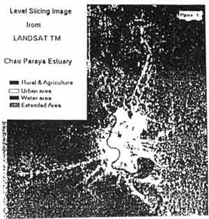
Figure 1. shown urbanization extension stretch fingures zone
All high resolution satellite imageries have been distinguished displayed water dispersion pattern, either examine or monitor suspended solid sediment diffuse efficient, being installed at estuary including with Atmospheric correction technique has been under primary analysis in order to illustrate transmittance and path radiance through single-linear regression analysis between radiance, which computed from satellite data and ground truth radiances (by spectrometer ) at a major curve in the Chao Phra-ya river course, whose both side-swings in wide looops presenting narrow meander strip of 625 meters wide as shown in figures 2,4 and 5.
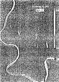
Figure 2. illustrated actual water dispersion and presisely ocntaminated quality location along the side swings of wide loops
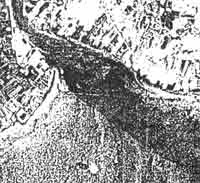
Figure 3. presented a dominant from and natureal dredge according to consistency navigation activity and current movement.
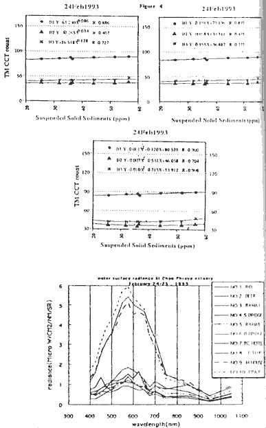
Figure 4 . indicated relationship among imnput data (sediment and density)
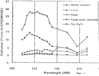
Figure 5 monitored relationship between wavelength and radiance of each sample position.
Data Aquisite:
Geometric correction was applied to satellite images, therefore ground referenced information could be compared to satellite images.
Enhancement and coloured density slicing technique has been employed to enhance surface water dispersion pattern and front, which shown potential of suspended sediment solid activities.
The overlay utilities among spectacular bands (2,3,4,5) and dates, did play an important role to signal hint on either surface water distribution characteristic or dominant front of these estuary.
Atmospheric corrections have been under primary analysing to illustrate transmittance and path radiance by lincer regression analysis between remote radiance and surface radiances at different wavelengths.
Discussion:
Remote sensing imageries have distinguished displayed water dispersion which could be related to turbidity and suspended sediment.
Overlaying images of specific band (s) appear to assess surface water dispersion patten, movement, direction, fronts and salt intrusion as shown in figure 2 and 3.
Concentration change of suspended sediment solid has caused subjective productivity in amount of radiation reflected from water surface. Spectral reflectance would depend on suspended materials in water d\body which emitting electro-magnetic energy under their quality characteristics.
Salt intrusion and tidal effect have been illustrated in colour density settlement analysis.
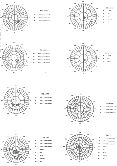
Figure 6. introduced the first completed presentation paramenters between wavelength and radiance of each important itemsalong the Chao-Phra-ya river.
Summary:
Classified urbanization extension stretched fingers zone, was indicated multi-prolongation direction upon 5 percentage of mean annual accerelation, while maximum dispersion density increase 11.5 percent in the same period.
Mathemathical analysis has appearented that remote sensing imagery (TM CCT count) has a rather closed relationship to suspended sediment solid thus is good in both logarithm regression analysis andd single-linear regreession anlysis but best in binomial regression analysis as shown in figure 4, but atmospheric correction did improve image quality through presenting more detail either along river ereach or precisely contaminated location on urban land area by illustrating similar dense situation as shown in figure 2; while dominant front and natural.
Dredge according to consistency navigation activity have been clearlyshown in figure 3.
All measured spectral reflectance on comparatived surface objects along the Chao-Phra-ya rach, were calibrated and transformed to absolute radiance then illustrated their dominently characteristic in monitoring area The water body reflectances were directly correlated to suspended sediment solid particle structure as shown in table 1, figure 5 and 6.
Reference:
Previous analysed research has been concentrated on prominent area of the Chao-Pra-ya estuary; deltaic area have been promoted from agrucultural area to urban one, accentuated several problems on river reach while Chao-Phra-ya river has been only fresh-water resource to this area. Sincedifficultiies in ground investigation costs and heavily boat transportaion have been concerned, tremendous satellite images techniques were intruduced to analyse historically.
Percentage difference, linear-regression analysis, correlation matrix and one-dimension statistical analysis were used to analyse among varios water quality parameters and satellite imageries data. A rather high correlation has resulted on correlation coefficient 0.946 (99 percentage significance). Geometric correction and Digital analysis has been selected potimum Band or Bands combination through those multi-enhancement techniques which were used to delineate water quality indifferent periods. Overlying utility has been expressed upon rectified water dispersion pattern including with productive navigation path way The Colour Density Slicing was achieved to such water pixel images, which has been efficiently considered to dominantly qualitative assessments of water dispersion pattern conditions were acquired upon five selected different date of LANDSAT TM data.
At present, the monitoring area composed of 80 kilometers long river reach 15 kilometers shore line to the East and 25 kilometers to the West (cover Prathumthani, Nonthaburi, Bangkok, and Samutprakan provinces)). Togetherwith classified existing land cover study of urban (dense settlement) indicates extension stretched fingers zone to the North, North-East and West prolongation direction while surface water dispersion illustrate density too Figure 1. Presents dense-urban area extension
Figure 1. shown urbanization extension stretch fingures zone
All high resolution satellite imageries have been distinguished displayed water dispersion pattern, either examine or monitor suspended solid sediment diffuse efficient, being installed at estuary including with Atmospheric correction technique has been under primary analysis in order to illustrate transmittance and path radiance through single-linear regression analysis between radiance, which computed from satellite data and ground truth radiances (by spectrometer ) at a major curve in the Chao Phra-ya river course, whose both side-swings in wide looops presenting narrow meander strip of 625 meters wide as shown in figures 2,4 and 5.
Figure 2. illustrated actual water dispersion and presisely ocntaminated quality location along the side swings of wide loops
Figure 3. presented a dominant from and natureal dredge according to consistency navigation activity and current movement.
Figure 4 . indicated relationship among imnput data (sediment and density)
Figure 5 monitored relationship between wavelength and radiance of each sample position.
Data Aquisite:
- TM Imageries were selected on the same date of field investigation Dec. 25, 1987 Dec. 14 , 1989 Jan 15 1990 ; Feb . 16 1990 Feb 24, 1993.
- Water quality data of Chao Phra ya estuary could be monitored by 15 stations located along river course and perpendicular to river mouth
- Classified existing land cover study upon booming urbaniation from 1987 to 1990 efficiently indicates extension stretched fingers zone.
- Spectrometer has been initiated on 10 investigation points along the Chao-Phra-ya river course, measured specteral characteristics of water at a time coincide with remote senor overflight. Ground truth investigation are upwelling radicnce reflected by white board, shadow lawn road and just above water surface.
Geometric correction was applied to satellite images, therefore ground referenced information could be compared to satellite images.
Enhancement and coloured density slicing technique has been employed to enhance surface water dispersion pattern and front, which shown potential of suspended sediment solid activities.
The overlay utilities among spectacular bands (2,3,4,5) and dates, did play an important role to signal hint on either surface water distribution characteristic or dominant front of these estuary.
Atmospheric corrections have been under primary analysing to illustrate transmittance and path radiance by lincer regression analysis between remote radiance and surface radiances at different wavelengths.
Discussion:
Remote sensing imageries have distinguished displayed water dispersion which could be related to turbidity and suspended sediment.
Overlaying images of specific band (s) appear to assess surface water dispersion patten, movement, direction, fronts and salt intrusion as shown in figure 2 and 3.
Concentration change of suspended sediment solid has caused subjective productivity in amount of radiation reflected from water surface. Spectral reflectance would depend on suspended materials in water d\body which emitting electro-magnetic energy under their quality characteristics.
Salt intrusion and tidal effect have been illustrated in colour density settlement analysis.
Figure 6. introduced the first completed presentation paramenters between wavelength and radiance of each important itemsalong the Chao-Phra-ya river.
Summary:
Classified urbanization extension stretched fingers zone, was indicated multi-prolongation direction upon 5 percentage of mean annual accerelation, while maximum dispersion density increase 11.5 percent in the same period.
Mathemathical analysis has appearented that remote sensing imagery (TM CCT count) has a rather closed relationship to suspended sediment solid thus is good in both logarithm regression analysis andd single-linear regreession anlysis but best in binomial regression analysis as shown in figure 4, but atmospheric correction did improve image quality through presenting more detail either along river ereach or precisely contaminated location on urban land area by illustrating similar dense situation as shown in figure 2; while dominant front and natural.
Dredge according to consistency navigation activity have been clearlyshown in figure 3.
All measured spectral reflectance on comparatived surface objects along the Chao-Phra-ya rach, were calibrated and transformed to absolute radiance then illustrated their dominently characteristic in monitoring area The water body reflectances were directly correlated to suspended sediment solid particle structure as shown in table 1, figure 5 and 6.
Reference:
- Murai shunji; Aplication of Remote Sensing in Asia and Oceania
- Murai Shunji, JARS; Remote Sensing Note 1993
- H. Vathananukij, S. Murai S Vibulsresth; Water Quality Analysis on Chao-Phra-ya Estuary using Remote Sensing Data (First version) ACRS 1993
- Y. Yasuoka: Measuring water quality of lake Ksumigaure