| GISdevelopment.net ---> AARS ---> ACRS 1994 ---> Water Resources |
Multi-scale Remote Sensing of
Ground and surface Water Interactions.
Tim R Mc Vicar1,
David LB Jupp1, Alex Hel1, V.K. Choubey2
and Li Lingtao3
1Division of Water Resource CSIRO, Canberra, ACT Australia.
2National Institute of Hydrology, Roorkee, Uttar Pradesh, India.
3North-West Institute of Soil and Water Conscrvation, CAS, yangling, Shaanxi Province, PR China.
1 Introduction1Division of Water Resource CSIRO, Canberra, ACT Australia.
2National Institute of Hydrology, Roorkee, Uttar Pradesh, India.
3North-West Institute of Soil and Water Conscrvation, CAS, yangling, Shaanxi Province, PR China.
The Loddon-Campaspe catchments (LCC) in northern Victoria, Australia, cover an area of 19400 km2. Land use in primarily agricultural including dryland and irrigation for crop and pasture production. Remnant stands of deeper rooted native woodland and forest cover 10% of the LCC. Changes to landcover by clearing for agriculture has altered the gydrologic balance. Subsequent rises in local and regional water tables are expressed on the surface as waterlogging and soil salinisation.
A collaborative project involving staff from CSIRO Division of Water Resources. CSIRO Centre for Environmental Mechanics and the Victorian Department of Conservation and Natural Resuurces has been established to understand round and surface water interactions for the prediction of water response to a prefect. For overviews of the environmental conditions in these catchments see Campaspe CWG (1992).
To comprehend the complexities the completies of water movement through the landscape and its expression at the surface, as either waterlogging or salinisation, multi-scale remotely sensed imagery is being liked with hydrologic process models, Remotely sensed data is providing insights into the spatial and temporal variations of water presence and movement, modelling is enabling us the comprehend variations in remotely For example, providing land use maps. Rate of land use change and regional estimates use change and regional estimates of LAI. Data used in (LANDSAT MSS & TM) and regional (AHRR), these are detailed in Section 3.
2. Monitorin Ground - Surface Water Interactions in a Water Balance
Waterlogging in the LCC occurs when saturated local or regional groundwater intersectios the upper metre of the soil column. Salinisation occurs when this water mobilises soil salt and when the water evaporates the salt is left at the soil surface. Changing vegetation management practices, by a combination of reducting amounts entering the groundwater aquifers or intercepting groundwater with deeper rooted vegetation, wil enable future waterlogging and salinisation the be minimised. The presence and movement of water in the landscape is the most improtant parmeter to the understanding and prediction of waterlogging and salinisation. The water budget for the root zone of the soil column can be written:
¶W/¶t=(P+I) - E - R + D - G (1)
Where W is water content of the root zone, p is Precipitation, I is Irrigation, E is Evaportranspiration, R is Runof D is dDischarge from the groundwater' and G is Recharge to the groundwater, all uniits in cm. Ignoring, for the moment, irigation, recharge and discharge, this rate equation can be integrated over days or weeks to ederive a simple difference equation for the incremental change in the soil water storage:
Wt - Wt-1 = Pt - Et - Rt (2)
Soil moisture increments by the net of rainfall (Pt) minus evapotranspiration (Et) and runoff (Rt) over the time period from t-1 to t resulting in a total at time t of Wt Typically, an information system for estimating soil moisture will utilise meteorological data to provide rainfall and the atmospheric demand for water, This demand can be estimated in various ways from records of air temperature, solar radiation, humidity and windspeed It can then be used with allowance for land cover type and condition to compute a potential evaportranspiration (Ep) This is the response of the land surface to the atmospheric demand for
Presented at the 15th Asian Conference on Remote Sensing, Bangalore, India, November 17-23, 1994. Water if soil water is not limiting. A water balance can be computed if an initial storage is known (W0) and if operating characteristics, for the area are known which define relationships between the water balance moisture availability (ma (WB)) and runoff fraction (rr) and soil moisture. For example:
ma(WB)=E/EP=f(Wt/Wmax)
and (3)
rr=R/P=g(Wt/Wmax)
Here, Wmax is the water which whould be available at field capacity. I gnoring recharge and discharge, the application of Equation (2) results in a time series for the water available in the root zone While this water balance model does not incorporate surface and ground water interactions these will be observed by thermal remote sensing. The aim is to bring the meteorological driven water balance model into agreement with indices obtained from thermal remote sensing and to analyse the spatial and temporal residuals in the remotely sensed derived indices to profile indications of ground and surface water interactions.
3. Role And Description of Remotely Sensed Data Sets
3.1 Catchment Scale (Airborne Data)
Airborne scanning devices offer flexible paramenterisation of geometric, radiomtric and temporal resolution. In the past two years we have gained considerable experience in all aspects of airborne remote sensing, including instrument operation, flight planning, image modelling, development of radiometric and geometric correction algrithms and coupling the rmote science with field based measurement science (Jupp et al. 1992b, Held and Juppp 1994, Jupp et al 1994b.)
The Compact Airborne Spectrographic Imager (CASI) a pushbroom imaging spectrugraph intended for acquisition of Visible and Near Infra-Red multispectral imagery from light aircraft. A " reflection diffraction grating spectrograph" disperses the light along the Charge Coupled Device to create the 288 spectral channels covering 379nm to 894nm spectrum. Each spectral channel (or array element) is in the order of 2nm wide. The CASI is operated in two preferred modes of imaging, spatial or spectral. Spatial mode collects image data limited to up to 19 user defined spectral channels. Spectral mode images the full spectral array response on a few nominated ground pixels. For further technical details of the CASI see Anger et al (1990) and Babey and Anger (1989).
Recently, narow-band reflectance indices sensitive to plant physiological conditions have been proposed (Gamon et al. 1990) Epoxidation state of leaf xanthophyll pigments produces a detectable changes in leaf reflectance at 531 nm this is closely related to changes in photosynthetic light use at the leaf and canopy levels. The 'physiological reflectance index (PRI) takes advantage of this absorption feature to map photosynthetic efficiency at various levels of water and nutrient stress.
Horler et al. (1983) and Miller
et al. (1991) have focused on the 'red-edge. The region where leaf
reflectance rises frm low reflectance in the red to high reflectance in
the near infra-red. Laboratory studies with spectroradiometers have found
movements in the inflection point and changes in the slope and amplitude
of the 'red-edge caused by water, nutrient and heavy-metal toxicity
stresses. Therefore a series of CASI images taken over the growing season
provides the means for separation of changes in reflectance due to changes
in leaf chlorophyll concentration, from those caused by changes in leaff
stacking (ie.LAI)' as affected by affected by phenology or stress.
During the spring-summer of 94-95 CASI imagery will be obtained three times over areas which have mix of groundwater recharge and discharge patches to monitor plant physiological response to natural seasonal change coupled with conditions arising from groundwater discharge. We expect the CASI to detect early stress conditions and to separate areas where the vegetation has access to deeper salinised ground water as opposed to areas where plants extract soil water whch originates solely from precipitation. This will indicate areas in the landscape which may be partially waterlogged but not exhibit surface salt. Mapping currently salt affected lands (high albedo) within paddocks of grasses (lower albedo) is routine, we are attempting to do more than this.
3.2 Local Scale (LANDSTA Data)
LANDSAT Satellites have carried the MSS sensor since 1972 (i.e. satelllites 1 to 5) and the TM sensor since 1983 (satellites 4 and 5) For sensor and satellte characteristics refer to Harrisison and Jupp (1989). Three scenes are required to cover the entire LCC, dates of TM imagery currently available are:
LANDSAT TM data will be atmosphericallly corrected to radiance values to allow regional plant growth models to be validated and to identify anomalies between the predicted radiance, as modelled by plant growth models (reference in here), and the observed signal. This will enable us to determine focus areas for more detailed data collection, usually remotely sensed (CASI) with syupporting field data, to assist in the detailed modelling.
MSS data has been used to provide base line mapping of land use within the L/CC the dates of the MSS data, all obtained from LANDSAT 4, are as follows.
3.3 Regional Scale (AVHR Data)
Daytime thermal AVHRR data is used to provide measures of moisture availability through Normalise Difierence Temperature Index (NDTI) images. Daytime reflective AVHRR data is used to provide Normalised Difference Vegetation Index (NDVI) images. Eighty (80) day-night pairs, approximatelyu monthly from June 1986 to present have been archived for all South-East Australia. The theory am application of linking water balance to energy balance by thermal remote sensing have been outlined in previous research (Mc Vicar et al., 1991, 1992, 1993, Jupp et al. 1990, 199222a, 1994a)
The AVHAVHR data for the 212188 pointsoints Thermal remote ending I an intantaneou observation of the tatu of the energy balance hich rovide the mean to gain information about oil moiture. Vartiation in daytime AVHARR data I governed by the amount of ater and the ease ith hich it I transferred from the surr2af2ace to the atmosphere, via ET (Jupp et al 1990)
The NDTI has the form as follows, see (Mc Vicar et al 1992, Jupp et al 1994a:
NDTI= (T¥ - Ts) (T¥ - T0) (4)
Where T is the modeled surface temperature if there is an infinite surface resistance, that is, ET a is zero Ts is the surfacr temperature observed from the AVHRR sensor, and T0 is the modelled surface temperature if there were zero surface resistance; hence Eta equals Etp T and T0 can be though of a the physically-limited upper and lower temperatures for given meteorological conditions and surface resistances. Thy define an envelope in which meaningful AVHRR derived surface temperatures must fail If Ts is close to the T0 it is an indication of conditions being wet, whereas if Ts is close to the T value dryness is signified.
Calibrated NDVI images allow regional estimates of LAI to Provided to the plant Growthmodellen the correction of ndvi for the estimation of lai is a routine procedure for remote sensing and will not be detailed further in this paper (gutan 1991)
3.4 Ancillary Data Used with Remotely Sensed Data
Ancillary data used in the project includes a discharge data base (DDB) in which location, severity size of the salinised disharge areas were record areas of high infiltration and very high infiltration been mapped for 7 of the 16 1:100 000 scale maps which cover the LCC. This mapping has only been done for the Ordovician Sediments. Daily meteorological data, consisting of maximum and minimum air temperatures and rainfall, from Jan 1980 until the present was obtained from the Bureau of Meteorological fo the four sites within the LCC. Daily micrometerological parmenters, such as solar radiation and potential evapotranspiration, were modelled from tis data using the methods outlined in Mc Vicar et al (1991, 1992) and Jupp et al (1994a) The 6 year lead period between the start of the water balance modelling (1980) and the comparison with AVHRR thermal observations (1986) means that the importance of the initial water storeage (W0) is reduced.
4. Methods
4.1 Local Scale Mapping
The LANDSAT MSS data was colour balanced (not atmospherically corrected, as we do not plan to use it for model validation) using microBRIAn. Geometric correction was performed using MOS_MOD (MOSaic MODel - new program in microBRIAN suite). MOS_MOD calculates geometric polynomial transformations taking into account ground control points(GCP'S) which were identifid in more than one image These points were either primary GCP's (that is, an Australian Map Grid value was associated with the point ) or secondary GC's (that is points which have no AMG value but can be identified in each image). The resulting radiometric and geometric corrected image has been classified into 7 Lvel II landcover classes using the microBRIAN classification methodology outlined in Harrison and Jupp (1994) . This landcover mapping will be ground truthed this summer (94_9594_95) using both field sites and historic aerial photographs taken at the time of the imagery. This mapping exercise provides us with a baseline landcover map which wil
l be compared to a LANDSAT TM classification of more recent data This will enable us to build GIS layers of landcover and landcover change which has occurred in the last decade.
4.2 Regional Scale Energy and Waer Balance Modelling
Size thresholds were placed on the discharge sites to decide which to extract from the AVHRR time serhresholds were placed on the discharge sites to decide which to extract from the AVHRR time series. In the Loddon and Campaspe catchments only discies. In the Loddon and Campaspe catchments only discharge sites greater tharge sites greater than 50 ha were extracted from the DDB. However, no discharge sites within the Campaspe were greater than this threshold, hence for the Campaspe the size was reduced to 1550 ha were extracted from the DDB. However, no discharge sites within the Campaspe were greater than this threshold, hence for the Campaspe the size was reduced to 1550 ha were extracted from the DDB. However, no discharge sites within the Campaspe were greater than this threshold, hence for the Campaspe the size was reduced to 1550 ha were extracted from the DDB. However, no discharge sites within the Campaspe were greater than this threshold, hence for the Campaspe the size was reduced to 1550 ha were extracted from the DDB. However, no discharge sites within the Campaspe were greater than this threshold, hence for the Campaspe the size was reduced to 15 ha Within the Campaspe we have established a focus catchment, Axe Creek. Within Axe Creek discharge sites greater than 5 Within the Campaspe we have established a focus catchment, Axe Creek. Within Axe Creek discharge sites greater than 5 ha were used in the study.
The discharge sites were manually ha were used in the study.
The discharge sites were manually lacated on the infiltration maps. For each discharge site a set of secondary points in the vicinity of the primary discharge site were located. Secolacated on the infiltration maps. For each discharge site a set of secondary points in the vicinity of the primary discharge site were located. Secondary points were located inside polygons of high and very high ndary points were located inside polygons of high and very high infiltration. Sites regardes as inerinfiltration. Sites regardes as inert (being neither in the areas mapped as high infiltration nor a known discharge site) and large water bodies wer and large water bodies were also selected. The lane also selected. The landcoverdcover for all point for all points s was detwas deterermined from visual assessment of LANDSAT data.
The number of Points extracted form the AVHRR time series was xpanded from the original 7 the original 72 point2 points by 14s by 142 seeccondaondary poiointnts which allow comparisons to the made due to landcover, hydrologic and terrain related variable. The AVHRR data for the 218 points (the 4 BofMet stations were included) were extracted from the 82 day nitht pairs presently archived. The energy balance and water balance programs developed by Jupp et al (1994a) were run for all points. This work is in progress and initial results will be presented at the conference.
5. Data Integration
A combined GIS/Remote sensing system which combines the different data sets for the regional AVHRR modelling is illustrated in Figure 1. In this diagram there are two main streams. Firstly GIS integration of land cover and meteorological data is used to develop a water balance model such as quation (2) The general spatial information such asgeology andtopography is combined at meteorological stations where weather data are normally available on a daily basis. Data from the stations mnust be extrapolate to other areas by trend surface or other methods of objective analysis. Frm this system may be produced water halances and estimates of waterlogged and potential salinised sites.
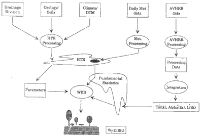
Figure 1
Secondly, the processing of AVHRR data to produce a gappy time series of spatially distributed measurements of surface temperature (Ts), albedo (a) and Leaf Area Index (LAI). At these overpass times and dates, daily weather data and other GIS data can be extracted. In the section labelled WEB the twostreams are brought together through the Water and Energy Balance models. The streams are compatible when the surface temperatures estimated from the Water Balance match those measured at the times of the satellite overpass at the stations. Interpolating these results to other times must be through te water balance mode. Extrapolating spaially must use the spatial detail of the remote sensing. Softwae have been developed which take the daily meteorological data to provide information for both the daily water balance model and the energy balance model which are used at the itimes when a AVHRR overpass occurs.
Data integration procedures for the castchment and local scale remote sensing will use similar techniques as those developed for the regionl modelling, as shown in Figure 1. For CASI data in situ field measurements of plant paramenters (LAI, leaf nitrogen concentration etc and environmental conditions (air temperatures and the radiation environment) need to be integrated with the airborne data. For the local mapping field data sites need to be located. Between all data sets the technical considerations of mappping from one scale to another have been addressed. This allows te prediction of salinisation and the influence that altering vegetation cover has on the water balance to be coupled transparently from the remote sensing data sets to the GIS hydrologic modelling environment.
6 Acknowlegements
Anger, C.D., Barbey, S.K. and Adamson, R.A. (1990) A new approach to imagin spectroscopy. Processings of SPIE 72 p. 72-86.
Babey, S.K and Anger, C.D. (1989) A compact airborne spectrograpgic imager (CASI) garss 1989 Procedings, 2, pp 1028-1031.
Campaspe Community Working Group (CWG) (1992) Campaspe Catchment Salinity Management Plan A Draft for Public comment, 111 pp.
Gamon, J.A. Field, C.B., Bilger, W. Bjorkman, O, redeen, A.L. and Pefiuelas, J. (1990) Remote sensing of the xamtophyll cycle and chlorophyll fluorescence in sunflower leaves and canopies Oecologia 85:1-7
Gutman G.G.(1991) Vegetation Indices from AVHRR An Update and Future Prospects Remote Sening of Environment 35, 121-136.
Harrison, B.A. and Jup, D.L.B. (1989) introduction to Remotely Sensed Data, CSIRO Publicatons, 141 pp.
Harrison, B.A. and Jup, D.L.B. (1994) intoduction to Image Classification (In Press).
Held, A.A. & Jupp, D.L.B.J. (1994) Use of the Compact AirboRne Spectral Imager (CASI) For Remote Sensing of Vegetationn Function and Dynamics. Proceedings 7th Australasian Remote Sensing Conference March 1994 Melbourne Australia, pp. 573-580.
Horler, D.N., Dockray, M. and Barber, J (1983) The red edge of plant reflectance, Intl. J Rerov Senrts. 4(2) 273-288.
Jup, D.L.B., Walker, J. Kalma, J.D. and McVicar, T.R. (1990) Using Thermal Remote Sensing to Monitor land Degradation and Salinization in the Murrray-Darling Basin of australia. Proceedings of the Twenty-Third International Symposium On Remote Sensing of the Environment, Bangkik, Thailand, April 18-25 pp 1011-1021.
Jupp. D.L.B., McVicar, T.R., Walker, J., Held, A.A. Kalma, J.D. and McDonald, E.R. (1992a) Remote sensing of change in components of the regional water blance of the Murray Darling Basin using stuellite imaged and spatially registered environmental data, Final Report to the LWRRDC Project CWA 6 CSIRO Division of Water Resources, Consulatancy Report Number 92/31
Jupp,, D.L.B., Held, A Byrne, G Hutton, P., McDonald, E and Park in, D. (1992b) The Potential Use of AirborneScannersforMonitoringAlgalDynamics in Australian Inland Waters. CSIROOfficeOf Space Science, Applications Publication No.30, 141 pp
Jupp, D.L.B. Tian G. McVicar, T.R. Yi Q. and Fuqin, L (1994a) Monitoring Soil Moisture Effectsand Drought using Remotely Sensed AVHRR Date Part I Theory. Irrigation Science (In Prep.)
Jupp, D.L.B., Kirk, J.T.O. and Harris, G.P. (1994b)Detection, Identificationand Mapping of Cyanobacteria Using Remote Sensing to Measure the Optical Quality of Turbid Inland Waters, Australian Journal of Marine Freshwater Research 45 (In print)
Loddon Community Working Group (CWD) (1992) Loddon Catchment Salinity Management Plan -A Draft for Public Comment, 133 pp.
Miller J.R. Jiyou Wu, Boyer, M.G., Belanger M. and Hare, EW (1991) Remote sensing with physical models of soil moisture status to monitor land degradation and drought. Proceedings of the 12th Asian Conference on Remote Sensing, SEAMEO, Singapore, October 30-November 5,pp A 1.2.1-A1.2.6.
McVicar, T.R., Jupp, D.L.B., Yang, X and Tian, G (1992) Linking Regional Water Balance Models with Remote Sensing proceedings of the 13th Asian Conference on Remote Sensing, Ulaanbaatar Mongolia, October 7-11, pp. B. 6.1.B. 6.6.
McVicar, T.R., Tian G., Jup, D.L.B. and Li F (1993) Soil moisture and drought monitoring using remote sensing. Proceedings of the 14th Asian Conference on Remote Sensing, Tehran, Iran, October 12-17,. Pp A 5. 1-A. 5.6.
During the spring-summer of 94-95 CASI imagery will be obtained three times over areas which have mix of groundwater recharge and discharge patches to monitor plant physiological response to natural seasonal change coupled with conditions arising from groundwater discharge. We expect the CASI to detect early stress conditions and to separate areas where the vegetation has access to deeper salinised ground water as opposed to areas where plants extract soil water whch originates solely from precipitation. This will indicate areas in the landscape which may be partially waterlogged but not exhibit surface salt. Mapping currently salt affected lands (high albedo) within paddocks of grasses (lower albedo) is routine, we are attempting to do more than this.
3.2 Local Scale (LANDSTA Data)
LANDSAT Satellites have carried the MSS sensor since 1972 (i.e. satelllites 1 to 5) and the TM sensor since 1983 (satellites 4 and 5) For sensor and satellte characteristics refer to Harrisison and Jupp (1989). Three scenes are required to cover the entire LCC, dates of TM imagery currently available are:
| PATH 94 | PATH 93 | |
| Date 1 : 8 Dec 1989 Bands 2,3,4,5 | Date 1:7 Mar 1990 Bands 2,3,4,5,7 | Row 85 |
| Date 2: 1 Jan 1993 Bands 2,3,4,5 | Date 2: 10 Jan 1993 Bands 2,3,4,5 | |
| Date 1: 6 Feb 1991 Bands 2,3,4,5 | ROW 86 | |
| Date 2: 16 Apr 1993 Bands 2,3,4,5 |
LANDSAT TM data will be atmosphericallly corrected to radiance values to allow regional plant growth models to be validated and to identify anomalies between the predicted radiance, as modelled by plant growth models (reference in here), and the observed signal. This will enable us to determine focus areas for more detailed data collection, usually remotely sensed (CASI) with syupporting field data, to assist in the detailed modelling.
MSS data has been used to provide base line mapping of land use within the L/CC the dates of the MSS data, all obtained from LANDSAT 4, are as follows.
| PATH 94 | PATH 93 | |
| Date : 2 Feb 1984 Bands 4,5,6,7 | Date: 10 Jan 1984 Bands 4,5,6,7 | Row 85 |
| Date: 23 Nov 1983 Bands 4,5,6,7 | ROW 86 |
3.3 Regional Scale (AVHR Data)
Daytime thermal AVHRR data is used to provide measures of moisture availability through Normalise Difierence Temperature Index (NDTI) images. Daytime reflective AVHRR data is used to provide Normalised Difference Vegetation Index (NDVI) images. Eighty (80) day-night pairs, approximatelyu monthly from June 1986 to present have been archived for all South-East Australia. The theory am application of linking water balance to energy balance by thermal remote sensing have been outlined in previous research (Mc Vicar et al., 1991, 1992, 1993, Jupp et al. 1990, 199222a, 1994a)
The AVHAVHR data for the 212188 pointsoints Thermal remote ending I an intantaneou observation of the tatu of the energy balance hich rovide the mean to gain information about oil moiture. Vartiation in daytime AVHARR data I governed by the amount of ater and the ease ith hich it I transferred from the surr2af2ace to the atmosphere, via ET (Jupp et al 1990)
The NDTI has the form as follows, see (Mc Vicar et al 1992, Jupp et al 1994a:
NDTI= (T¥ - Ts) (T¥ - T0) (4)
Where T is the modeled surface temperature if there is an infinite surface resistance, that is, ET a is zero Ts is the surfacr temperature observed from the AVHRR sensor, and T0 is the modelled surface temperature if there were zero surface resistance; hence Eta equals Etp T and T0 can be though of a the physically-limited upper and lower temperatures for given meteorological conditions and surface resistances. Thy define an envelope in which meaningful AVHRR derived surface temperatures must fail If Ts is close to the T0 it is an indication of conditions being wet, whereas if Ts is close to the T value dryness is signified.
Calibrated NDVI images allow regional estimates of LAI to Provided to the plant Growthmodellen the correction of ndvi for the estimation of lai is a routine procedure for remote sensing and will not be detailed further in this paper (gutan 1991)
3.4 Ancillary Data Used with Remotely Sensed Data
Ancillary data used in the project includes a discharge data base (DDB) in which location, severity size of the salinised disharge areas were record areas of high infiltration and very high infiltration been mapped for 7 of the 16 1:100 000 scale maps which cover the LCC. This mapping has only been done for the Ordovician Sediments. Daily meteorological data, consisting of maximum and minimum air temperatures and rainfall, from Jan 1980 until the present was obtained from the Bureau of Meteorological fo the four sites within the LCC. Daily micrometerological parmenters, such as solar radiation and potential evapotranspiration, were modelled from tis data using the methods outlined in Mc Vicar et al (1991, 1992) and Jupp et al (1994a) The 6 year lead period between the start of the water balance modelling (1980) and the comparison with AVHRR thermal observations (1986) means that the importance of the initial water storeage (W0) is reduced.
4. Methods
4.1 Local Scale Mapping
The LANDSAT MSS data was colour balanced (not atmospherically corrected, as we do not plan to use it for model validation) using microBRIAn. Geometric correction was performed using MOS_MOD (MOSaic MODel - new program in microBRIAN suite). MOS_MOD calculates geometric polynomial transformations taking into account ground control points(GCP'S) which were identifid in more than one image These points were either primary GCP's (that is, an Australian Map Grid value was associated with the point ) or secondary GC's (that is points which have no AMG value but can be identified in each image). The resulting radiometric and geometric corrected image has been classified into 7 Lvel II landcover classes using the microBRIAN classification methodology outlined in Harrison and Jupp (1994) . This landcover mapping will be ground truthed this summer (94_9594_95) using both field sites and historic aerial photographs taken at the time of the imagery. This mapping exercise provides us with a baseline landcover map which wil
l be compared to a LANDSAT TM classification of more recent data This will enable us to build GIS layers of landcover and landcover change which has occurred in the last decade.
4.2 Regional Scale Energy and Waer Balance Modelling
Size thresholds were placed on the discharge sites to decide which to extract from the AVHRR time serhresholds were placed on the discharge sites to decide which to extract from the AVHRR time series. In the Loddon and Campaspe catchments only discies. In the Loddon and Campaspe catchments only discharge sites greater tharge sites greater than 50 ha were extracted from the DDB. However, no discharge sites within the Campaspe were greater than this threshold, hence for the Campaspe the size was reduced to 1550 ha were extracted from the DDB. However, no discharge sites within the Campaspe were greater than this threshold, hence for the Campaspe the size was reduced to 1550 ha were extracted from the DDB. However, no discharge sites within the Campaspe were greater than this threshold, hence for the Campaspe the size was reduced to 1550 ha were extracted from the DDB. However, no discharge sites within the Campaspe were greater than this threshold, hence for the Campaspe the size was reduced to 1550 ha were extracted from the DDB. However, no discharge sites within the Campaspe were greater than this threshold, hence for the Campaspe the size was reduced to 15 ha Within the Campaspe we have established a focus catchment, Axe Creek. Within Axe Creek discharge sites greater than 5 Within the Campaspe we have established a focus catchment, Axe Creek. Within Axe Creek discharge sites greater than 5 ha were used in the study.
The discharge sites were manually ha were used in the study.
The discharge sites were manually lacated on the infiltration maps. For each discharge site a set of secondary points in the vicinity of the primary discharge site were located. Secolacated on the infiltration maps. For each discharge site a set of secondary points in the vicinity of the primary discharge site were located. Secondary points were located inside polygons of high and very high ndary points were located inside polygons of high and very high infiltration. Sites regardes as inerinfiltration. Sites regardes as inert (being neither in the areas mapped as high infiltration nor a known discharge site) and large water bodies wer and large water bodies were also selected. The lane also selected. The landcoverdcover for all point for all points s was detwas deterermined from visual assessment of LANDSAT data.
| Size Discharge Pt ha (x) | Catchment | #discharge points | #secondary points |
| x>100 | Loddon | 19 | 46 |
| 50>x>100 | Loddon | 21 | 43 |
| 16>x>45 | Campaspe | 11 | 17 |
| 5>x>16 | Axe Ck | 21 | 36 |
The number of Points extracted form the AVHRR time series was xpanded from the original 7 the original 72 point2 points by 14s by 142 seeccondaondary poiointnts which allow comparisons to the made due to landcover, hydrologic and terrain related variable. The AVHRR data for the 218 points (the 4 BofMet stations were included) were extracted from the 82 day nitht pairs presently archived. The energy balance and water balance programs developed by Jupp et al (1994a) were run for all points. This work is in progress and initial results will be presented at the conference.
5. Data Integration
A combined GIS/Remote sensing system which combines the different data sets for the regional AVHRR modelling is illustrated in Figure 1. In this diagram there are two main streams. Firstly GIS integration of land cover and meteorological data is used to develop a water balance model such as quation (2) The general spatial information such asgeology andtopography is combined at meteorological stations where weather data are normally available on a daily basis. Data from the stations mnust be extrapolate to other areas by trend surface or other methods of objective analysis. Frm this system may be produced water halances and estimates of waterlogged and potential salinised sites.
Figure 1
Secondly, the processing of AVHRR data to produce a gappy time series of spatially distributed measurements of surface temperature (Ts), albedo (a) and Leaf Area Index (LAI). At these overpass times and dates, daily weather data and other GIS data can be extracted. In the section labelled WEB the twostreams are brought together through the Water and Energy Balance models. The streams are compatible when the surface temperatures estimated from the Water Balance match those measured at the times of the satellite overpass at the stations. Interpolating these results to other times must be through te water balance mode. Extrapolating spaially must use the spatial detail of the remote sensing. Softwae have been developed which take the daily meteorological data to provide information for both the daily water balance model and the energy balance model which are used at the itimes when a AVHRR overpass occurs.
Data integration procedures for the castchment and local scale remote sensing will use similar techniques as those developed for the regionl modelling, as shown in Figure 1. For CASI data in situ field measurements of plant paramenters (LAI, leaf nitrogen concentration etc and environmental conditions (air temperatures and the radiation environment) need to be integrated with the airborne data. For the local mapping field data sites need to be located. Between all data sets the technical considerations of mappping from one scale to another have been addressed. This allows te prediction of salinisation and the influence that altering vegetation cover has on the water balance to be coupled transparently from the remote sensing data sets to the GIS hydrologic modelling environment.
6 Acknowlegements
Anger, C.D., Barbey, S.K. and Adamson, R.A. (1990) A new approach to imagin spectroscopy. Processings of SPIE 72 p. 72-86.
Babey, S.K and Anger, C.D. (1989) A compact airborne spectrograpgic imager (CASI) garss 1989 Procedings, 2, pp 1028-1031.
Campaspe Community Working Group (CWG) (1992) Campaspe Catchment Salinity Management Plan A Draft for Public comment, 111 pp.
Gamon, J.A. Field, C.B., Bilger, W. Bjorkman, O, redeen, A.L. and Pefiuelas, J. (1990) Remote sensing of the xamtophyll cycle and chlorophyll fluorescence in sunflower leaves and canopies Oecologia 85:1-7
Gutman G.G.(1991) Vegetation Indices from AVHRR An Update and Future Prospects Remote Sening of Environment 35, 121-136.
Harrison, B.A. and Jup, D.L.B. (1989) introduction to Remotely Sensed Data, CSIRO Publicatons, 141 pp.
Harrison, B.A. and Jup, D.L.B. (1994) intoduction to Image Classification (In Press).
Held, A.A. & Jupp, D.L.B.J. (1994) Use of the Compact AirboRne Spectral Imager (CASI) For Remote Sensing of Vegetationn Function and Dynamics. Proceedings 7th Australasian Remote Sensing Conference March 1994 Melbourne Australia, pp. 573-580.
Horler, D.N., Dockray, M. and Barber, J (1983) The red edge of plant reflectance, Intl. J Rerov Senrts. 4(2) 273-288.
Jup, D.L.B., Walker, J. Kalma, J.D. and McVicar, T.R. (1990) Using Thermal Remote Sensing to Monitor land Degradation and Salinization in the Murrray-Darling Basin of australia. Proceedings of the Twenty-Third International Symposium On Remote Sensing of the Environment, Bangkik, Thailand, April 18-25 pp 1011-1021.
Jupp. D.L.B., McVicar, T.R., Walker, J., Held, A.A. Kalma, J.D. and McDonald, E.R. (1992a) Remote sensing of change in components of the regional water blance of the Murray Darling Basin using stuellite imaged and spatially registered environmental data, Final Report to the LWRRDC Project CWA 6 CSIRO Division of Water Resources, Consulatancy Report Number 92/31
Jupp,, D.L.B., Held, A Byrne, G Hutton, P., McDonald, E and Park in, D. (1992b) The Potential Use of AirborneScannersforMonitoringAlgalDynamics in Australian Inland Waters. CSIROOfficeOf Space Science, Applications Publication No.30, 141 pp
Jupp, D.L.B. Tian G. McVicar, T.R. Yi Q. and Fuqin, L (1994a) Monitoring Soil Moisture Effectsand Drought using Remotely Sensed AVHRR Date Part I Theory. Irrigation Science (In Prep.)
Jupp, D.L.B., Kirk, J.T.O. and Harris, G.P. (1994b)Detection, Identificationand Mapping of Cyanobacteria Using Remote Sensing to Measure the Optical Quality of Turbid Inland Waters, Australian Journal of Marine Freshwater Research 45 (In print)
Loddon Community Working Group (CWD) (1992) Loddon Catchment Salinity Management Plan -A Draft for Public Comment, 133 pp.
Miller J.R. Jiyou Wu, Boyer, M.G., Belanger M. and Hare, EW (1991) Remote sensing with physical models of soil moisture status to monitor land degradation and drought. Proceedings of the 12th Asian Conference on Remote Sensing, SEAMEO, Singapore, October 30-November 5,pp A 1.2.1-A1.2.6.
McVicar, T.R., Jupp, D.L.B., Yang, X and Tian, G (1992) Linking Regional Water Balance Models with Remote Sensing proceedings of the 13th Asian Conference on Remote Sensing, Ulaanbaatar Mongolia, October 7-11, pp. B. 6.1.B. 6.6.
McVicar, T.R., Tian G., Jup, D.L.B. and Li F (1993) Soil moisture and drought monitoring using remote sensing. Proceedings of the 14th Asian Conference on Remote Sensing, Tehran, Iran, October 12-17,. Pp A 5. 1-A. 5.6.