| GISdevelopment.net ---> AARS ---> ACRS 1994 ---> Poster Session |
Regional Geology and
Structure of the Sakoli Belt, India from Space Data Application
S. G. Krishna, S. M. Dutta
Geological Survey of India, Nagpur 440 006
S. G. Krishna, S. M. Dutta
Geological Survey of India, Nagpur 440 006
Abstract
The Sakoli belt, covering 7000 sq km (20° 30' - 21°30' N/79°15' - 80°15'E) in Maharashtra, defines a distinct triangular shaped structural outline within Central Indian Precambrian shield and was evolved through mutual interplay of the multiphase compressional/extensional tectonism. Complex structural - metamorphic history of the terrain can only be understood with collation and synthesis of all types of regional geological parameters. The objective of present study was to add remote sensing knowledge inputs in defining structural evolution of the domain.
Synoptic overview of the regional geological/structural assimilation inherent in the satellite data products depict interrelationship of different structural phenomena in shaping the rock fabric over the sakoli belt. Visual interpretation of IRS-FCC of bands 2,3, & 4 on 1:250,000 scale supplemented by geocoded FCC on 1:50,000 scale from critical locales helped in deriving the following important conclusions; (I) Sakoli belt comprises steeply dipping assemblages of meta sediments/meta sediments, meta volcanics, (ii) ENE-SW and N-S are the two major lineament trends strongly influencing the regional structural fabric and geology, (iii) ENE-WSW is younger than N-S lineament, transacting the later in number of occasions (iv) strong interplay along these two lineaments in different magnitudes/dimensions, often shapes the deformed rock fabric similar the deformed rock fabric similar to fold geometry, (v) ENE-SW lineaments greatly obliterated earlier fold geometry by dragging and displacement, (vi) Northern tip of the sakoli triangle has been affected most, by the two major transaction lineaments resulting in deformation sand translation of rock bodies considerably along ENE trend.
The study thus revels that faulting rather than folding has played dominant role in shaping the belt and evolving it structural/metamorphic history. Genetic interrelation of ENE-WSW and N-S linear structural trends, role of faults/lineaments in shaping the deformed rock fabrics similar to fold geometry and dragging of major folds towards NEN are among the main observations from the critical synthesis of visually interpreted remotely sensed data inputs.
Introduction
The sakoli belt, a part of Central Indian shield, still remains a main domain of geological studies or its complex basin geometry, structural, metamorphic and metallogenetic characters. This had called for intensive and exhaustive regional geological studies for the tectonic evolution of the region. The prime objectives of the study were, therefore to dicipher : (I) regional geological/structural set up through recognition of macroscopic scale structural elements and their correlation (ii) effects of linear fabrics on the mappable rock units (iii) influence of extensional/compressional tectonic grains in shaping basing geometry. Present study with space-borne data products was intended to supplement and update the existing data base as well as to upbuild the knowledge of tectonic history.
Sakoli belt covers about 7000 sq km area (20030' - 21030'N/79015'- 80015'E) in the eastern part of Maharashtra, India. The study was carried out mainly on IRS-LISS-I FCC of bands 2,3,4 on 1:250,000 scale aided by geocoded FCC on 1:50,000 scale of critical locales and analysis / synthesis of derived knowledge inputs with the back ground of available geological informaion about the domain. Tome, texture, drainage patterns, cover types, percepted relief, hues, features orientation and association form the essential input image parameters (Subins 1978) for the interpretation of broad lithological /structural fabrics, delineation of regional geological elements as well as their mutual/spatial interrelation within the study domain.
Regional Geology
The sakoli group of rocks define a broad triangular shaped outcrop pattern on IRS data products. The edges of the triangle, delineating the contact between the major rock groups and the older basement, are of structural original obliterated considerably by later deformation episodes. Analysis/synthesis of visually interpreted image parameters aided by real world feedbacks by critical areas reveal that the board lithological assemblages of this belt comprise group of metasedimentaries (Quartzite, Banded Iron Formation (BIF), Phylites, mica schists) and metabasics (metabasalts and amphibolites). The sakoli group is bordered by Nandgaon acid volcanics/quatrtzites and Amgaon gneisses to the east and Tirodi gneisses to the northwest and north. These major staraightgrahic contacts are defined by regional shears/faults, depicted n the imagery as prominent linear morpho-tectonic signatures. The tectonic contacts were further corroborated from the ground truth by the presence of brecciated quarts veins and mylonites. The southern contact of the belt with the basement gneiss is not well defined probably due to the mutual effects in varying degree and magnitude of basement structural fabrics and later phases of deformation magmatism the contacts with Sullavai meta sediments to the south/southwest and Dongargarh granites to the south-east could be easily demarcated on the imagery because of their distinct physiograhic expressions.
Morphologic Expression :
The area exhibits significant denudational topography with subdued, structure-controlled ridges and plains at various elevations showing higher degrees of areal plantation that linear stream erosion. The basement gneiss dotted with residual hillocks of granites, quantzites and ultramafics covers major part of the study domain as low planted topography with n imprint of structure-controlled dendritic to subrectangular drainage network. The gneissic country west of Wainganga river forms a distinct textural unit on the imagery due to the presence of number of valley fills and intense agricultural activity. Quartzires, Bonded Iron Formation (BIF), meta-basic and some of intercalated quants-phyllites of sakoli metasedimentaly possess characteristic relief, prominent linearity and tonal variations. Around Chandori, Lakhni and Palandur, meta sediments comprising schist/phyllite form planated topography in the central part of the belt.
Structural Fabric :
The structural frame work of the area under study portrays reprint of complex interplay of three distinct deformation phases. The main thrust of the present work has been to provide data on details of regional structural trends and to understand the relative significance of different deformation episdoes in shaping the rock-geometry. The regional structural set-up is best depicted by the disposition of major lithological formations in the terrain. The sharp crested quartzite ridges, linear meta structurally subdued gneissic country were discriminated on the imagery along with fracture, lineament, fault, patterns. The interpretation of the orbital data revealed that the "Sakoli triangle" is mainly represented by two major regional structural grains. The earlier grain trends in N-S/NNE-SSW direction on the eastern side, parallel to the Khairagar trend while the younger structural grain roughly along ENE-WSW to NE-SW direction on the western side shows parallelism to the Sausar trends. These two trends merge to from an acute angle (200 to 300) geometry south west of Gondia. This sharp crested structural geometry on the mesoscopic scale is also reflected on the imagery at various locations within the Sakoli mestaseiments such as near Rawanwari, Kesalwara and Fatehpur. A similar acute angle fold like geometry due to intersection of two transacting lineament fabrics is noticed near Fatehpur characterized by flexuring of litho unit sin between the fracture planes. South-eastern and south-western ends of the belt are also marked by similar linear fabric geometry revealed from the acute intersection of mappable rock units. There is a gradual divergence of the beds, from the northern tip with broad concavity towards the center becoming considerably wide and diffused along the southern margin. This resulted into a nearly triangular shape outline of the belt with broad ill defined base. Widening of the belt, increase in aerial extent, diversity of rock assemblages and increasingly anisotropism of rock fabrics progressively reduce the intensity of deforming forces towards the south becoming recognizable only in hard/brittle formation. This phenomenon is well documented on the space data base from the central part of the belt where mutual interplay of linear fabrics are more restricted along the marginal zones than towards the center. Along the southern margin no such strong linearity in the fabrics is observed except E-W trending lineament controlling the course of Wainganga river. Great aerial extent, complex interplay of multiple of basement and overlying metasediments in the movement dynamics were the probable reasons in developing such diffused margin.
Synoptic overview of various structural elements, their synthesis suggest presence of three distinct structural locales in the sakoli belt with their significant structural characteristics as described below:
i) Eastern segment :
Major structural grain on the eastern side follows N-S trend and is represented by the set of parallel lineaments spreading over a zone of 10 o 15 km. Width between salebardi and Nawegaon in the south Gondia in the north. In conformity to prevalent structural fabric of the locale, resistant litho units, joints, fractures and faults form a N-S trending array of linear geometry with broad swing from NNW in the south to NNE in the north. This gradual change in the fabric orientation is possibly due to later superposition of a fold geometry with E-W axial trend which is also responsible for broad concavity of the belt to wards center. This zone however, less affected by later cross faults and off-sets indicating relatively little influence of ENE-WSW structural fabrics. This is further confirmed from an overall structural conformity of the eastern margin with Nandgaon, Kairgarh and Chilpi groups of rocks exposed in the adjacent belt to the east and north east.
ii) Western Segment :
This covers western part of the sakoli triangle between Kuhi and Gondia with characteristic ENE-WSW/NE-SW trending rock fabrics/lineaments conforming roughly with the structural grains of Sausar Group in the north. It forms a narrow belt of closely spaced lineaments/fractures affected by later deformation as reflected by later deformation as reflected in NW-SE dislocations of major trend lines. Analysis of the orientation of structural elements reveals a gradual swing from ENE to NE towards north. This segment, thus, reflects strong influence of later tectonic fabric in contrast to eastern segment.
iii) North-Eastern Segment :
Lithological assemblages comprising this part are strongly deformed and often dragged in varying magnitude due to strong mutual interaction of two dominant transacting linear structural elements. This effect of deformation kinematics has even the reprint over the resistant quartzites / BIF formations near Bodilkasa, Fathepur for which beds are rotated and moved extensional tectonism and their influence in shaping the geometry of rock fabrics could be best deciphered from this part. Mappable rock units on space borne data products show repeated chagne in their structural trend as well flexuring of litho units around Kondaverra, Hanumantola and Dhakni close to the northern tip. Both the N-S trending lineaments/rock fabrics f the east and NNE-SSW trending litho elements/structures of the west converge and rotate to NE-SE/ENE-WSW trend and dragged towards NEN probably due to the effect of later ENE-WSW tectonism.
Discussions and Conclusions
Synoptic over view, visual interpretation of image, parameters, ground truth from critical locales, their collation and synthesis have helped in bringing out the regional geological framework and to refine the boundaries of major litho groups, the study has also contributed greatly to understand the geometry of the regional linear structural elements and their control on lithological attitudes particularly in the north eastern part of the belt. The structural fabric of the area is conspicuously controlled by two major tectonic trends. Space borne knowledge inputs reveal that the N-S grain precalent in Nandgaon and Kharigarh group of rocks to the east, extends further west upto Bhandara, Where it is transacted by NEN-WSW/NE-SW regional lineament at many places. The ENE-WSW fabric transacts N-S trend suggesting it a later tectonic imprint much subdued to the east. Further more, this later NE-SW trend extends beyond the northern tip of the sakoli basin around Gondia and merges with the Central Indian Suture (CIS) (Yedekar, et al 1990)
Regional distribution pattern of lineaments, fractures, faults, and rock bodies ad depicted on remotely sensed data products suggest that the area has been subjected to varying degree if shearing and slicing. The movement kinematics of multiphase deformation have [possibly resulted in juxtapostion of lithologies of contrasting metamorphic grades at various parts of the basin. Mineralisations in the belt have also been affected by complex interaction of extensional/compressional tectonism resulting into extremely diverse pattern of localisation. Lithological disposition and linear fabric geometry of the deform rock suggest that mutual interaction of the two transacting linaments played dominent rolel in shaping triangular apex of the northern tip. Original regional fold geomatry might have been modified greatly by later linear tectonics also responsible for flexuring and dragging of fold closures towards ENE for a considerable extent. Thus, it is obvious that faulting rather than folding played greater role in shaping the rock fabrics of the domain and evolving its complex metamorphic / metallogenetic history. Propensity o movement and intensity of tectonism on the rock assemblages reduce increasingly to the south for the spread of deforming forces over the greater aerial extent and manifestation of the effects are only depicted through mesoscopic scale intersecting lineaments and deformed rock units similar to acute angle fold geometry at places.
Acknowledgement
The authors express their gratitude to Shri R.N Padhi, the Dy Director General, Geological Survey o India, Central Region, and Dr. K. Sarkar , Geologist (Sr.) for valuable suggestions in shaping the paper. Shri K. Muthuraman, Director and Mrs. S. Muthuraman, Gr. Steno I, GSI, are acknowledged for their help in computer aided word processing work for the paper.
References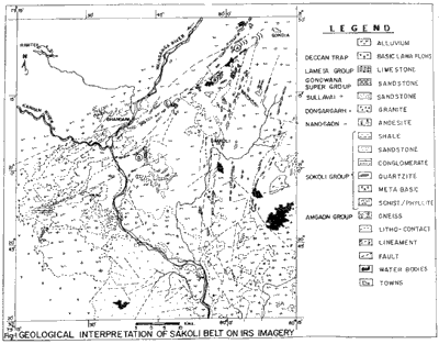
Figure 1 Geological Interpretation of Sakoli Belt on IRS Imagery
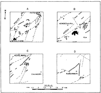
Figure 2 Transacting Lineament Pattern in Sakoli Belt (The locations A, B, C, D are referred in figure 1)
The Sakoli belt, covering 7000 sq km (20° 30' - 21°30' N/79°15' - 80°15'E) in Maharashtra, defines a distinct triangular shaped structural outline within Central Indian Precambrian shield and was evolved through mutual interplay of the multiphase compressional/extensional tectonism. Complex structural - metamorphic history of the terrain can only be understood with collation and synthesis of all types of regional geological parameters. The objective of present study was to add remote sensing knowledge inputs in defining structural evolution of the domain.
Synoptic overview of the regional geological/structural assimilation inherent in the satellite data products depict interrelationship of different structural phenomena in shaping the rock fabric over the sakoli belt. Visual interpretation of IRS-FCC of bands 2,3, & 4 on 1:250,000 scale supplemented by geocoded FCC on 1:50,000 scale from critical locales helped in deriving the following important conclusions; (I) Sakoli belt comprises steeply dipping assemblages of meta sediments/meta sediments, meta volcanics, (ii) ENE-SW and N-S are the two major lineament trends strongly influencing the regional structural fabric and geology, (iii) ENE-WSW is younger than N-S lineament, transacting the later in number of occasions (iv) strong interplay along these two lineaments in different magnitudes/dimensions, often shapes the deformed rock fabric similar the deformed rock fabric similar to fold geometry, (v) ENE-SW lineaments greatly obliterated earlier fold geometry by dragging and displacement, (vi) Northern tip of the sakoli triangle has been affected most, by the two major transaction lineaments resulting in deformation sand translation of rock bodies considerably along ENE trend.
The study thus revels that faulting rather than folding has played dominant role in shaping the belt and evolving it structural/metamorphic history. Genetic interrelation of ENE-WSW and N-S linear structural trends, role of faults/lineaments in shaping the deformed rock fabrics similar to fold geometry and dragging of major folds towards NEN are among the main observations from the critical synthesis of visually interpreted remotely sensed data inputs.
Introduction
The sakoli belt, a part of Central Indian shield, still remains a main domain of geological studies or its complex basin geometry, structural, metamorphic and metallogenetic characters. This had called for intensive and exhaustive regional geological studies for the tectonic evolution of the region. The prime objectives of the study were, therefore to dicipher : (I) regional geological/structural set up through recognition of macroscopic scale structural elements and their correlation (ii) effects of linear fabrics on the mappable rock units (iii) influence of extensional/compressional tectonic grains in shaping basing geometry. Present study with space-borne data products was intended to supplement and update the existing data base as well as to upbuild the knowledge of tectonic history.
Sakoli belt covers about 7000 sq km area (20030' - 21030'N/79015'- 80015'E) in the eastern part of Maharashtra, India. The study was carried out mainly on IRS-LISS-I FCC of bands 2,3,4 on 1:250,000 scale aided by geocoded FCC on 1:50,000 scale of critical locales and analysis / synthesis of derived knowledge inputs with the back ground of available geological informaion about the domain. Tome, texture, drainage patterns, cover types, percepted relief, hues, features orientation and association form the essential input image parameters (Subins 1978) for the interpretation of broad lithological /structural fabrics, delineation of regional geological elements as well as their mutual/spatial interrelation within the study domain.
Regional Geology
The sakoli group of rocks define a broad triangular shaped outcrop pattern on IRS data products. The edges of the triangle, delineating the contact between the major rock groups and the older basement, are of structural original obliterated considerably by later deformation episodes. Analysis/synthesis of visually interpreted image parameters aided by real world feedbacks by critical areas reveal that the board lithological assemblages of this belt comprise group of metasedimentaries (Quartzite, Banded Iron Formation (BIF), Phylites, mica schists) and metabasics (metabasalts and amphibolites). The sakoli group is bordered by Nandgaon acid volcanics/quatrtzites and Amgaon gneisses to the east and Tirodi gneisses to the northwest and north. These major staraightgrahic contacts are defined by regional shears/faults, depicted n the imagery as prominent linear morpho-tectonic signatures. The tectonic contacts were further corroborated from the ground truth by the presence of brecciated quarts veins and mylonites. The southern contact of the belt with the basement gneiss is not well defined probably due to the mutual effects in varying degree and magnitude of basement structural fabrics and later phases of deformation magmatism the contacts with Sullavai meta sediments to the south/southwest and Dongargarh granites to the south-east could be easily demarcated on the imagery because of their distinct physiograhic expressions.
Morphologic Expression :
The area exhibits significant denudational topography with subdued, structure-controlled ridges and plains at various elevations showing higher degrees of areal plantation that linear stream erosion. The basement gneiss dotted with residual hillocks of granites, quantzites and ultramafics covers major part of the study domain as low planted topography with n imprint of structure-controlled dendritic to subrectangular drainage network. The gneissic country west of Wainganga river forms a distinct textural unit on the imagery due to the presence of number of valley fills and intense agricultural activity. Quartzires, Bonded Iron Formation (BIF), meta-basic and some of intercalated quants-phyllites of sakoli metasedimentaly possess characteristic relief, prominent linearity and tonal variations. Around Chandori, Lakhni and Palandur, meta sediments comprising schist/phyllite form planated topography in the central part of the belt.
Structural Fabric :
The structural frame work of the area under study portrays reprint of complex interplay of three distinct deformation phases. The main thrust of the present work has been to provide data on details of regional structural trends and to understand the relative significance of different deformation episdoes in shaping the rock-geometry. The regional structural set-up is best depicted by the disposition of major lithological formations in the terrain. The sharp crested quartzite ridges, linear meta structurally subdued gneissic country were discriminated on the imagery along with fracture, lineament, fault, patterns. The interpretation of the orbital data revealed that the "Sakoli triangle" is mainly represented by two major regional structural grains. The earlier grain trends in N-S/NNE-SSW direction on the eastern side, parallel to the Khairagar trend while the younger structural grain roughly along ENE-WSW to NE-SW direction on the western side shows parallelism to the Sausar trends. These two trends merge to from an acute angle (200 to 300) geometry south west of Gondia. This sharp crested structural geometry on the mesoscopic scale is also reflected on the imagery at various locations within the Sakoli mestaseiments such as near Rawanwari, Kesalwara and Fatehpur. A similar acute angle fold like geometry due to intersection of two transacting lineament fabrics is noticed near Fatehpur characterized by flexuring of litho unit sin between the fracture planes. South-eastern and south-western ends of the belt are also marked by similar linear fabric geometry revealed from the acute intersection of mappable rock units. There is a gradual divergence of the beds, from the northern tip with broad concavity towards the center becoming considerably wide and diffused along the southern margin. This resulted into a nearly triangular shape outline of the belt with broad ill defined base. Widening of the belt, increase in aerial extent, diversity of rock assemblages and increasingly anisotropism of rock fabrics progressively reduce the intensity of deforming forces towards the south becoming recognizable only in hard/brittle formation. This phenomenon is well documented on the space data base from the central part of the belt where mutual interplay of linear fabrics are more restricted along the marginal zones than towards the center. Along the southern margin no such strong linearity in the fabrics is observed except E-W trending lineament controlling the course of Wainganga river. Great aerial extent, complex interplay of multiple of basement and overlying metasediments in the movement dynamics were the probable reasons in developing such diffused margin.
Synoptic overview of various structural elements, their synthesis suggest presence of three distinct structural locales in the sakoli belt with their significant structural characteristics as described below:
i) Eastern segment :
Major structural grain on the eastern side follows N-S trend and is represented by the set of parallel lineaments spreading over a zone of 10 o 15 km. Width between salebardi and Nawegaon in the south Gondia in the north. In conformity to prevalent structural fabric of the locale, resistant litho units, joints, fractures and faults form a N-S trending array of linear geometry with broad swing from NNW in the south to NNE in the north. This gradual change in the fabric orientation is possibly due to later superposition of a fold geometry with E-W axial trend which is also responsible for broad concavity of the belt to wards center. This zone however, less affected by later cross faults and off-sets indicating relatively little influence of ENE-WSW structural fabrics. This is further confirmed from an overall structural conformity of the eastern margin with Nandgaon, Kairgarh and Chilpi groups of rocks exposed in the adjacent belt to the east and north east.
ii) Western Segment :
This covers western part of the sakoli triangle between Kuhi and Gondia with characteristic ENE-WSW/NE-SW trending rock fabrics/lineaments conforming roughly with the structural grains of Sausar Group in the north. It forms a narrow belt of closely spaced lineaments/fractures affected by later deformation as reflected by later deformation as reflected in NW-SE dislocations of major trend lines. Analysis of the orientation of structural elements reveals a gradual swing from ENE to NE towards north. This segment, thus, reflects strong influence of later tectonic fabric in contrast to eastern segment.
iii) North-Eastern Segment :
Lithological assemblages comprising this part are strongly deformed and often dragged in varying magnitude due to strong mutual interaction of two dominant transacting linear structural elements. This effect of deformation kinematics has even the reprint over the resistant quartzites / BIF formations near Bodilkasa, Fathepur for which beds are rotated and moved extensional tectonism and their influence in shaping the geometry of rock fabrics could be best deciphered from this part. Mappable rock units on space borne data products show repeated chagne in their structural trend as well flexuring of litho units around Kondaverra, Hanumantola and Dhakni close to the northern tip. Both the N-S trending lineaments/rock fabrics f the east and NNE-SSW trending litho elements/structures of the west converge and rotate to NE-SE/ENE-WSW trend and dragged towards NEN probably due to the effect of later ENE-WSW tectonism.
Discussions and Conclusions
Synoptic over view, visual interpretation of image, parameters, ground truth from critical locales, their collation and synthesis have helped in bringing out the regional geological framework and to refine the boundaries of major litho groups, the study has also contributed greatly to understand the geometry of the regional linear structural elements and their control on lithological attitudes particularly in the north eastern part of the belt. The structural fabric of the area is conspicuously controlled by two major tectonic trends. Space borne knowledge inputs reveal that the N-S grain precalent in Nandgaon and Kharigarh group of rocks to the east, extends further west upto Bhandara, Where it is transacted by NEN-WSW/NE-SW regional lineament at many places. The ENE-WSW fabric transacts N-S trend suggesting it a later tectonic imprint much subdued to the east. Further more, this later NE-SW trend extends beyond the northern tip of the sakoli basin around Gondia and merges with the Central Indian Suture (CIS) (Yedekar, et al 1990)
Regional distribution pattern of lineaments, fractures, faults, and rock bodies ad depicted on remotely sensed data products suggest that the area has been subjected to varying degree if shearing and slicing. The movement kinematics of multiphase deformation have [possibly resulted in juxtapostion of lithologies of contrasting metamorphic grades at various parts of the basin. Mineralisations in the belt have also been affected by complex interaction of extensional/compressional tectonism resulting into extremely diverse pattern of localisation. Lithological disposition and linear fabric geometry of the deform rock suggest that mutual interaction of the two transacting linaments played dominent rolel in shaping triangular apex of the northern tip. Original regional fold geomatry might have been modified greatly by later linear tectonics also responsible for flexuring and dragging of fold closures towards ENE for a considerable extent. Thus, it is obvious that faulting rather than folding played greater role in shaping the rock fabrics of the domain and evolving its complex metamorphic / metallogenetic history. Propensity o movement and intensity of tectonism on the rock assemblages reduce increasingly to the south for the spread of deforming forces over the greater aerial extent and manifestation of the effects are only depicted through mesoscopic scale intersecting lineaments and deformed rock units similar to acute angle fold geometry at places.
Acknowledgement
The authors express their gratitude to Shri R.N Padhi, the Dy Director General, Geological Survey o India, Central Region, and Dr. K. Sarkar , Geologist (Sr.) for valuable suggestions in shaping the paper. Shri K. Muthuraman, Director and Mrs. S. Muthuraman, Gr. Steno I, GSI, are acknowledged for their help in computer aided word processing work for the paper.
References
- Sabins, Floyd F (1978) Remote sEnsing, Principles and Interpretation. Freeman and Company, U.S.A
- Yedekar, D.B Jain, S..C Nair, K.K.K and Dutta, K.K (1990). The Precambrian of Central India, Sepcial Publication NO. 28, GSI CR
Figure 1 Geological Interpretation of Sakoli Belt on IRS Imagery
Figure 2 Transacting Lineament Pattern in Sakoli Belt (The locations A, B, C, D are referred in figure 1)