| GISdevelopment.net ---> AARS ---> ACRS 1994 ---> Poster Session |
Regional Geomorphological
Survey for Landuse Programming Over the Narmada Basin, India
R N Padhi, S.G. Krishna, K. Sarkar and S. M Dutta
Geoological Survey of India -Nagpur 440 0006
R N Padhi, S.G. Krishna, K. Sarkar and S. M Dutta
Geoological Survey of India -Nagpur 440 0006
Abstract
A regional Geomorphological Survey conducted in part of the Narmada Basin using both IRS and Landsat MSS data to deduce landform patterns, their inter-rela-tionships and influence on the prepsent day topography as a prelude to geoecologically viable landuse programming led to trhe redognition of 9 landform units constituting basin morphography under three genetic types, namely, structural, gener=tic types, namely, structural, extrusive and fluvial. These were, however, modified essentially by subsequeny denudational dynamics. The morphological defelopment of the basin landscape comprising rocks beloging to different ages including Quaternary alluvium are in all possibilities, controlled by the Son Narmada tectonic lineament (a fundamental fracture) and its subsequent reactivations.
The study of various landform pattersns and their sppital interrelationship reveals three stages of geomorphic evolution leading to the development of the present day morphography over the studies domain. These include: (i) endogenic crustal movement towards structual manifestation into first order regional morphography, (ii) extrusive phases of lava topography, and (iii) fluvial depositional episodes. The denudational processes which operted in the basin throught the entire geomorphic cycle resulted in the development of a number of timeindependent lower order landforms on the present day topography.
A geoecologicallly sustained and viable landuse programme for the evolved landscape includes: (i) sub-urban growth, agriculature and small scale land based industries on the floow plains (ii)cash crop cultivation on the low lying plains and colluial foot slopes, (iii) high level plateaux for forestry and holiday resorts, hill ridges and slopes fior afforestation scheme, (iv) low lying plateaux for new areas of urbanisation.
Introduction
it is since 1980's that a more rational approach to landuse programming has become day to day task on global scale as a process of environment taol conservation scheme due to increase of urbanisation and industriablisation. Since the past two decades, the exponent of thematic geomorphological survey and mapping have shown a phenomenal change from classical methods of landform cleassification to the present day status of landscape/terrain eveluation to meet the growing needs of land-based economic activities in ecosphere. At this juncture a regional geomorphological survey covering about 18,000 sq km area between Jabalpur and Hoshangabad of Madhya Pradesh, India (22.30 - 23 . 30 N/77.00 - 80 . 15 /e) using IRS LISS I FCC of bands 2.3.4. and Landsat MSS - FCC of bands bands 1. 2. 3. On 1:250,000 scale was launched in part of the narmada Basin with a view to deciphering the landform patterns and their potential in framing a viable landuse programme for the watershed zone. Modern concept of applied geomorphological survey in fact, comprises analysis of various topographic attributes, regionalisation of landform patterns in their ecological context and estimation of land-water resources potential in terms of land scape morphograpy=hy. The present exercise intends to provide pretinent information in an integrated manner to enable comprehension and optimal utilisation of landforms potential in viable way necessary for the vast stretch of the Narmada watershed zone. The collateral information about various attributes of Basin topogoraphy have been obtained from topographic maps on 1:250 000 scale and colleated with the space data inputs.
Geological Set up
The Narmada watershed is under lain by number of older rocks belonging to different stratigraphic horozons. Jajor constituent litho-units aie the sedimentaries of Vindhyan and Gondwana Sur\per Groups followed by Deccan Trap basalts. The Bijawar Group of metasedimentaries and gneissic complex of Archaean-proterozoic age are the monor constituents contributing to the Basin giology. Quaternary alluvium in confined essanetially to the Narmada valley The disposition of the litho units ate in conformity with ENE WSW trending Son narmada tectonic lineanment which has influenced the development of basin land scape. The SonNarmada lineament considenred to be an active tectonic element perhaps right from the pre Cambrian times has had its influence on the geology and geomorphology of the region in the subsequeny geological periods (West, 1962)
The Gondwanas and the Deccan Traps constitute the bulk composition of ENE WSW trending Satpura range of the south of Narmada river; while in the north the Vindhyan sedimentaries occupy a vast area in the form of regional plateau with an escarpment paral lel to Son -Narmada treand.
Topographic attributes: The various morphographic attributes obtained fromn the annalysis of tpographic maps as well as from imagery ary the concern of relief, slope and texture of the basinal landscape. The relief pattern generates a topography of stepped plateau forms over Gondwanas, Vindhyans and Deccan Traps strike ridges over the Bi jawars and plains mostly over the Gondwanas and Quaternaries The topographic regionalisation of the basin morphography in respect of relief attribute comprises: (i) less than 350 m elevation above msl, the slopes, etc (ii) between 350 m and 500 m elevation above msl. The topography is fashioned with ridge and valley forms and lower plateau surfaces. (iii) between500 m and 650m above msl, the topography is sculptured into high level plateaux and ridges over the sedimenteries. (iv) above 650 m elevation from msl , the topography is attributed by high level plateau forms only over the Deccan Traps.
The slope attribute of the watershed topography is espressed by its bumodal distribution having polarity towards south and north with respects to the Narmada basin axis; while an overal slope of the basin axis is toweards west . The textural attribute of the topography defines the drainage development patterns inscribed on the relief forms. Y and large, trellis, parallel nad subnrectangular patterns characterise the plateaux and hill ridtges, becoming dindritic and sub parallel predominantly in the low lying valleys.
The Narmada Basin is strongly elengated along ENE wsw TRENDING Son Narmada lineament which guided the course of the Narmada river The river valley shows gradul broadening from Jabalpur in the east to Hoshangabad in the west with a drop of 60 m elevation for a distance of about 300 km.
Landforms classification: The landform patterns generated through differentiation of topography and spatiaal distribution of relief elements with respect to geologic times have promoted conceptualisation in the evolution of spatially designed numbr of time independent landform units on the topography. In the process of analysis 9 landform units were identified and delineated on the space data products covering the study domain (Krishna, 1992). The landform units thus delineated have been grouped under three genetic units following I.T.C. scheme of geomorphic classification (versteppen, et al 1968). The distribution of landforms as portrayed shows unique pattern of relief development through geologic ages under various endogenic and exogenic processes. The ntography of the Narmada Basin is sujected to renewed sculputuijg esentially by denudational dynamics resulting in the creation of more younger topography favour able for the development of alluvial landscpe in the subsequent periods. The classification of landforms (fig.1)iqueness lies in thus mnade was based on the following criteria: (i)the fact that the older structure/ lava induced geologic atteibute (morphostructures), genesis and relief for the plateaux occurring over the Vindhyans, Gondwanas and Dec can Treaps (ii) similarly the plain landforms were identified and grouped based on their geologic events, processes and altitude factor; (iii) the ridges and valleys were kept as separate class because of their distinctive mophology and bed rock structure; (iv) colluvial foot slope including fans at the base of plateaux would definitely enjoys a separate morphological status within the matrix of landforms that signifies a totally different generic process.
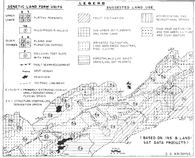
Figure 1 Zonal Landforms Pattern & Proposed Landuse Scheme
Plateau
The development of plateau forms in the watershed areas of the Narmada basian was initiated with the topographic differentialtion resulted from the interaction of multiply tectonism in the Vindhyan and Gondwana sediments of subsequently by extensive Deceean Trap extrusion. Obviously, the topographic differentiation accentuated by denudational dynamics led to the evolutuion of polygenetic plateau forms. These include plateaux over the sedimentary rocks (Vindhayans and Gondwanas) coccupying at 400-500m and 550-650 m altitude above msl as well as the plateaux over the Deccan Traps at 350 m - 500m and 700m -900 m above msl which were differentiated on the topography through a process of varied denudational agencies. The mophographic regionaliseation of plateauforms was, however, achieved through recognition of regional relief pttern int two levels separated by 500 m altitude. The high level plateau surfaces fare, in general, more dissected and have gentle gradient than their low level counterparts.
Ridges and valleys
These landform hve developed mostly over Bi jawar metasedimentaries and were subjected to significant denudation, controlled strongly by ENE WSW fabric. The unit is restricted only to abov e 300 m elevation between the uppwer level plateau and plains as close spaced, sharp creasted, linear ridges and valleys having relief amplitude ranges from 100 to 150 m.
Plain landform:
The unit includes both planation surfaces and flood plains. The remnant planar surfaces over the low lying Gondwana sedimentaries and Deccan Traps between elevation 250 m and 400 m above msl are essentially featureless relief forms of denudational origin and thus could be correlated with the 350 m level regional planation surface in the Peninsula.
The flood plains contributed by the Narmada drainage system are the other important plain land forms representing the valley landscape. The width of the alluvial plains ranges from 30 to 45 km for a length of 325 km with an over all gentle gradient towards west. Flood plain features, like, cut-off meanders, palaeo-meander scrolls, abandoned channels, etc are anmong a few observable features on the stablised surfaces. The unit, however , shows two distinct surfaces constituted by older flood plain and younger flood plain materials.
Colluvial foot slope including fans
An extensive colluvial fan surfaces at the foot slope of lower level structurral plateeauoccupying mostly along the southe rn fringe of the Narmada valleyu constitutes a low relief coalescing fans of gravity induced fluvial origin. The general surrfaces vaies from 2 to 5 at the proximal end and becomes more gentler towards the centre of the valley.
The classification and documentation of landforms on the map (Fig. 1) as discerned from the analysis of the space data is conjunction with topographic detils may invoke certain characterisation of the landform patterns, as a whole, in the study domain, These include; (a) marked parallellism of the palteaux ridges and valleys grossly along ENE WSWdirection; (b) the ENE-WSW ridgevelley topographic expression is strikingly influenced by the alternating soft and resistant rocs (c) the tributaries in most ases are ransvers to the main geologic structure in the area following topographic slope; (d) the stream density and the extent of the alluvial cover are relatively more on the southern side of the valley than on the northern side because of contrasting slope factor and underlying lithology; (e) the development of colluvial fans at the foot slopes of the Gondwana plateaux are more extensive than on the foot slopes of Vindhyan plateaux because of slope angle differences: (f) the tributaries that originated from the southern side appear to be of sluggish in character, showing development of channel meandering and brainding due to gentler slope condition and bed load traction (g) the valley starts widening towards west around Narsingpur and further broadens towards Hoshangabad and beyond following strong lithologic cnotrol (h) the change of Narmada cours near Jabalpur from nearly N-S to E-W direction follows two major lineaments, but around Hoshangabad a sinuous course of the river appears to tbe controlled by fractures having NE SW directions indicating subsequent nature of stream segments.
Land Utilisation Programme :
There is a spatial and ecological relationaship between relief forms/landforms and other elements of environmental complex, like , climate, water soil, vegetation, etc through catena principle (leser, 1978) Conssidering the factors of soil, water, moisture, vegetation and sub st rtum of landforms developmed over the Narmada watershed, a geoecologically sustained zonal land utilisation programme could be drawn (Fig. 1) to facilitate land-water based economic activities and environmental conservation in the following ways:
Laboratory synthesis and integration of imagery devived information inputs pertaining to relief forms and related topographic attributes enabled delineation of numbner of timeindependent landform units depicting the watershed morphography along with a system of conspicuous ENE WSW tectonic linenments that influenced the morpholongcal develpoment of the basin through geologic ages. A dominant ENE WSW tectonic grain along the Son-Nar mada vvalley has played a controlling role on the disposition of geology and subsequent morphologica development in the region.
The IRS data products utilised as basic study inputs have virtually offered tremendous interpretative capability in supplementing regional georphological survey for zonal landuse programming.
An applied aspect of the present geomorphological survey was however, initiated through prudent programming of land utilisation scve3me considering the landforms in their ecological context. This may be summarised as below:
The authors express their sincere thanks to Mrs. E.V. bastian and Mr N.L Nagarikar, GSI for their technical assistance. Sincers thanks are due to Mrs. Smitha Muthuraman, Steno Gro. I and Shri K. Muthuraman, Director, Geodata, GSI for their help and cooperation in preparing the camera ready printout of this paper.
References
A regional Geomorphological Survey conducted in part of the Narmada Basin using both IRS and Landsat MSS data to deduce landform patterns, their inter-rela-tionships and influence on the prepsent day topography as a prelude to geoecologically viable landuse programming led to trhe redognition of 9 landform units constituting basin morphography under three genetic types, namely, structural, gener=tic types, namely, structural, extrusive and fluvial. These were, however, modified essentially by subsequeny denudational dynamics. The morphological defelopment of the basin landscape comprising rocks beloging to different ages including Quaternary alluvium are in all possibilities, controlled by the Son Narmada tectonic lineament (a fundamental fracture) and its subsequent reactivations.
The study of various landform pattersns and their sppital interrelationship reveals three stages of geomorphic evolution leading to the development of the present day morphography over the studies domain. These include: (i) endogenic crustal movement towards structual manifestation into first order regional morphography, (ii) extrusive phases of lava topography, and (iii) fluvial depositional episodes. The denudational processes which operted in the basin throught the entire geomorphic cycle resulted in the development of a number of timeindependent lower order landforms on the present day topography.
A geoecologicallly sustained and viable landuse programme for the evolved landscape includes: (i) sub-urban growth, agriculature and small scale land based industries on the floow plains (ii)cash crop cultivation on the low lying plains and colluial foot slopes, (iii) high level plateaux for forestry and holiday resorts, hill ridges and slopes fior afforestation scheme, (iv) low lying plateaux for new areas of urbanisation.
Introduction
it is since 1980's that a more rational approach to landuse programming has become day to day task on global scale as a process of environment taol conservation scheme due to increase of urbanisation and industriablisation. Since the past two decades, the exponent of thematic geomorphological survey and mapping have shown a phenomenal change from classical methods of landform cleassification to the present day status of landscape/terrain eveluation to meet the growing needs of land-based economic activities in ecosphere. At this juncture a regional geomorphological survey covering about 18,000 sq km area between Jabalpur and Hoshangabad of Madhya Pradesh, India (22.30 - 23 . 30 N/77.00 - 80 . 15 /e) using IRS LISS I FCC of bands 2.3.4. and Landsat MSS - FCC of bands bands 1. 2. 3. On 1:250,000 scale was launched in part of the narmada Basin with a view to deciphering the landform patterns and their potential in framing a viable landuse programme for the watershed zone. Modern concept of applied geomorphological survey in fact, comprises analysis of various topographic attributes, regionalisation of landform patterns in their ecological context and estimation of land-water resources potential in terms of land scape morphograpy=hy. The present exercise intends to provide pretinent information in an integrated manner to enable comprehension and optimal utilisation of landforms potential in viable way necessary for the vast stretch of the Narmada watershed zone. The collateral information about various attributes of Basin topogoraphy have been obtained from topographic maps on 1:250 000 scale and colleated with the space data inputs.
Geological Set up
The Narmada watershed is under lain by number of older rocks belonging to different stratigraphic horozons. Jajor constituent litho-units aie the sedimentaries of Vindhyan and Gondwana Sur\per Groups followed by Deccan Trap basalts. The Bijawar Group of metasedimentaries and gneissic complex of Archaean-proterozoic age are the monor constituents contributing to the Basin giology. Quaternary alluvium in confined essanetially to the Narmada valley The disposition of the litho units ate in conformity with ENE WSW trending Son narmada tectonic lineanment which has influenced the development of basin land scape. The SonNarmada lineament considenred to be an active tectonic element perhaps right from the pre Cambrian times has had its influence on the geology and geomorphology of the region in the subsequeny geological periods (West, 1962)
The Gondwanas and the Deccan Traps constitute the bulk composition of ENE WSW trending Satpura range of the south of Narmada river; while in the north the Vindhyan sedimentaries occupy a vast area in the form of regional plateau with an escarpment paral lel to Son -Narmada treand.
Topographic attributes: The various morphographic attributes obtained fromn the annalysis of tpographic maps as well as from imagery ary the concern of relief, slope and texture of the basinal landscape. The relief pattern generates a topography of stepped plateau forms over Gondwanas, Vindhyans and Deccan Traps strike ridges over the Bi jawars and plains mostly over the Gondwanas and Quaternaries The topographic regionalisation of the basin morphography in respect of relief attribute comprises: (i) less than 350 m elevation above msl, the slopes, etc (ii) between 350 m and 500 m elevation above msl. The topography is fashioned with ridge and valley forms and lower plateau surfaces. (iii) between500 m and 650m above msl, the topography is sculptured into high level plateaux and ridges over the sedimenteries. (iv) above 650 m elevation from msl , the topography is attributed by high level plateau forms only over the Deccan Traps.
The slope attribute of the watershed topography is espressed by its bumodal distribution having polarity towards south and north with respects to the Narmada basin axis; while an overal slope of the basin axis is toweards west . The textural attribute of the topography defines the drainage development patterns inscribed on the relief forms. Y and large, trellis, parallel nad subnrectangular patterns characterise the plateaux and hill ridtges, becoming dindritic and sub parallel predominantly in the low lying valleys.
The Narmada Basin is strongly elengated along ENE wsw TRENDING Son Narmada lineament which guided the course of the Narmada river The river valley shows gradul broadening from Jabalpur in the east to Hoshangabad in the west with a drop of 60 m elevation for a distance of about 300 km.
Landforms classification: The landform patterns generated through differentiation of topography and spatiaal distribution of relief elements with respect to geologic times have promoted conceptualisation in the evolution of spatially designed numbr of time independent landform units on the topography. In the process of analysis 9 landform units were identified and delineated on the space data products covering the study domain (Krishna, 1992). The landform units thus delineated have been grouped under three genetic units following I.T.C. scheme of geomorphic classification (versteppen, et al 1968). The distribution of landforms as portrayed shows unique pattern of relief development through geologic ages under various endogenic and exogenic processes. The ntography of the Narmada Basin is sujected to renewed sculputuijg esentially by denudational dynamics resulting in the creation of more younger topography favour able for the development of alluvial landscpe in the subsequent periods. The classification of landforms (fig.1)iqueness lies in thus mnade was based on the following criteria: (i)the fact that the older structure/ lava induced geologic atteibute (morphostructures), genesis and relief for the plateaux occurring over the Vindhyans, Gondwanas and Dec can Treaps (ii) similarly the plain landforms were identified and grouped based on their geologic events, processes and altitude factor; (iii) the ridges and valleys were kept as separate class because of their distinctive mophology and bed rock structure; (iv) colluvial foot slope including fans at the base of plateaux would definitely enjoys a separate morphological status within the matrix of landforms that signifies a totally different generic process.
Figure 1 Zonal Landforms Pattern & Proposed Landuse Scheme
Plateau
The development of plateau forms in the watershed areas of the Narmada basian was initiated with the topographic differentialtion resulted from the interaction of multiply tectonism in the Vindhyan and Gondwana sediments of subsequently by extensive Deceean Trap extrusion. Obviously, the topographic differentiation accentuated by denudational dynamics led to the evolutuion of polygenetic plateau forms. These include plateaux over the sedimentary rocks (Vindhayans and Gondwanas) coccupying at 400-500m and 550-650 m altitude above msl as well as the plateaux over the Deccan Traps at 350 m - 500m and 700m -900 m above msl which were differentiated on the topography through a process of varied denudational agencies. The mophographic regionaliseation of plateauforms was, however, achieved through recognition of regional relief pttern int two levels separated by 500 m altitude. The high level plateau surfaces fare, in general, more dissected and have gentle gradient than their low level counterparts.
Ridges and valleys
These landform hve developed mostly over Bi jawar metasedimentaries and were subjected to significant denudation, controlled strongly by ENE WSW fabric. The unit is restricted only to abov e 300 m elevation between the uppwer level plateau and plains as close spaced, sharp creasted, linear ridges and valleys having relief amplitude ranges from 100 to 150 m.
Plain landform:
The unit includes both planation surfaces and flood plains. The remnant planar surfaces over the low lying Gondwana sedimentaries and Deccan Traps between elevation 250 m and 400 m above msl are essentially featureless relief forms of denudational origin and thus could be correlated with the 350 m level regional planation surface in the Peninsula.
The flood plains contributed by the Narmada drainage system are the other important plain land forms representing the valley landscape. The width of the alluvial plains ranges from 30 to 45 km for a length of 325 km with an over all gentle gradient towards west. Flood plain features, like, cut-off meanders, palaeo-meander scrolls, abandoned channels, etc are anmong a few observable features on the stablised surfaces. The unit, however , shows two distinct surfaces constituted by older flood plain and younger flood plain materials.
Colluvial foot slope including fans
An extensive colluvial fan surfaces at the foot slope of lower level structurral plateeauoccupying mostly along the southe rn fringe of the Narmada valleyu constitutes a low relief coalescing fans of gravity induced fluvial origin. The general surrfaces vaies from 2 to 5 at the proximal end and becomes more gentler towards the centre of the valley.
The classification and documentation of landforms on the map (Fig. 1) as discerned from the analysis of the space data is conjunction with topographic detils may invoke certain characterisation of the landform patterns, as a whole, in the study domain, These include; (a) marked parallellism of the palteaux ridges and valleys grossly along ENE WSWdirection; (b) the ENE-WSW ridgevelley topographic expression is strikingly influenced by the alternating soft and resistant rocs (c) the tributaries in most ases are ransvers to the main geologic structure in the area following topographic slope; (d) the stream density and the extent of the alluvial cover are relatively more on the southern side of the valley than on the northern side because of contrasting slope factor and underlying lithology; (e) the development of colluvial fans at the foot slopes of the Gondwana plateaux are more extensive than on the foot slopes of Vindhyan plateaux because of slope angle differences: (f) the tributaries that originated from the southern side appear to be of sluggish in character, showing development of channel meandering and brainding due to gentler slope condition and bed load traction (g) the valley starts widening towards west around Narsingpur and further broadens towards Hoshangabad and beyond following strong lithologic cnotrol (h) the change of Narmada cours near Jabalpur from nearly N-S to E-W direction follows two major lineaments, but around Hoshangabad a sinuous course of the river appears to tbe controlled by fractures having NE SW directions indicating subsequent nature of stream segments.
Land Utilisation Programme :
There is a spatial and ecological relationaship between relief forms/landforms and other elements of environmental complex, like , climate, water soil, vegetation, etc through catena principle (leser, 1978) Conssidering the factors of soil, water, moisture, vegetation and sub st rtum of landforms developmed over the Narmada watershed, a geoecologically sustained zonal land utilisation programme could be drawn (Fig. 1) to facilitate land-water based economic activities and environmental conservation in the following ways:
- The high level plateaux over the Vindhyans and Gondwana
sedimentatries having thick sandy loam soil and high seasonal
preecipitation ar designed by nature to support forestry in order to
retain specific ecologic conditions for wild life sanctuaires, holiday
resorts, This will enable water shed management by arrestin soil erosion
and acelerating higher rate of groundwater infiltration. To the
conterary, the high level plateaux over the ?deccan Traps having thin
rubbly soil cover but with hgih surface runoff could be brought under
fruit cultivation schenme especially for cashewnut, organge and magoes
with proper treatment. Some of the caves of historic interest carved
within the landform may be preserved as Archaeological antiquity to
encourage tourism.
- The lower level plateaux underlain by Gondwana sedimentaries south
of Itarsi exhibit gently rolling topography with development of thick
loamy soil. The Tawa reservoir, a primary source for irrigated
cultivation in the neighboruing areas, is situated on this landform and
needs to be portected from resevoir siltation. It is in view of the
fact, the entire land unit should be brought under intesive afforesation
programme to avoid accelarated soil erosion, reservoir siltation a well
as to create avenues for recreational activities. The laower level
plateaux on the Deccan Traps south west of jabalpur is essentially a
flat topography having content and with good groundwater potential The
area, geographially, could support sub-urban settlement keeping in view
the progressive expansion of Jablapur urban agglaomeration
- The ridge and valley forms characteristically development over the
Bi jawar meta-sedimentaries and occasionanlly on Vindhyans are covered
by scanty vegetation especially along the slope where there is
development of thin soil cover. This unit topographially is not suitable
for sustained agriculture. Patchy cultivation under available rain water
is being precticed only along the intervening vallleys. To prevent slope
erosion and to create a more aesthetic look of the landscape the unit
should be brought under afforestation scheme. Some of the thick
leucocracctic quartzite bands comprising the ridges could from a site
for stone quarries of cosmetic building material.
- The denudational plain devloped on the Deccan Traps as well as on the Gondwana sedimentaries having thick loamy soil and with good groundwater possibilities particularly in the vicinity of Lakhnadan and Itarsi have been found suitable for cash crop and oil seed cultivation as well as for activities relating to horticulature and silviculature. The fluvial depositional plains and the colluvial foot slope, I the other hand, by virtue of its soil fretility, moisture conent, surefacegroundwater availability and irrigation facility, apperar to be the favourable sites for extensive agriculature activity, sub-urban growth and land/agro based industries, like brick kiln, ceramic industry, fruit processing factory, sugar mills and pisciculature.
Laboratory synthesis and integration of imagery devived information inputs pertaining to relief forms and related topographic attributes enabled delineation of numbner of timeindependent landform units depicting the watershed morphography along with a system of conspicuous ENE WSW tectonic linenments that influenced the morpholongcal develpoment of the basin through geologic ages. A dominant ENE WSW tectonic grain along the Son-Nar mada vvalley has played a controlling role on the disposition of geology and subsequent morphologica development in the region.
The IRS data products utilised as basic study inputs have virtually offered tremendous interpretative capability in supplementing regional georphological survey for zonal landuse programming.
An applied aspect of the present geomorphological survey was however, initiated through prudent programming of land utilisation scve3me considering the landforms in their ecological context. This may be summarised as below:
- Agriculture land and agro based industries, sub-urban settlements, etc would find their respective places on the depositional plains; while farmland, cash ccrop oil seed cultivation horticulturel and Silvicultural activities would be better suited on the denudational plains; (ii) new areas of urbanisation and recreational ground could be extended into the low level plateaux (iii) forestry, wild life sanctuaries, holday resorts and Archaeological monments of historic interest should be conserved on the high level plateaux; while hill ridges and valleys may be brought under total afforestation scheme.
The authors express their sincere thanks to Mrs. E.V. bastian and Mr N.L Nagarikar, GSI for their technical assistance. Sincers thanks are due to Mrs. Smitha Muthuraman, Steno Gro. I and Shri K. Muthuraman, Director, Geodata, GSI for their help and cooperation in preparing the camera ready printout of this paper.
References
- Krishna, S.G. (1992) Geomorphological studies in parts of Narmada Basin of M.P. using LANDSAT and IRS-IA Imagery on 1:250,000 scale. Unpublished GSI Progress report.
- Leser, H (1978) Medium scale geomorphological mapping and land scape ecology, In Ed. By J. Demek, et al (1978) guide to mediumscale geomorphological mapping IG.U commission of Geomorphological survey and mapping P.P. 149-151
- Verstappen, H and van uidem R (1968) ITC system of gomorphological survey, ITC text ool of photo interpreation. Chapter- 7.
- West , W.D., (1962) The line of Narmda and Son rivers Current Sci Vol 31