| GISdevelopment.net ---> AARS ---> ACRS 1994 ---> Poster Session |
Environmental Analysis on
Vegetation in Chiba Prefecture
Masayuki Matsuoka and
Ryutaro Tateishi
Remote Sensing and Image Research Center,
Chiba University
1-33, Yayoi-cho, Inage-ku, Chiba, 263, Japan,
AbstractRemote Sensing and Image Research Center,
Chiba University
1-33, Yayoi-cho, Inage-ku, Chiba, 263, Japan,
The monitoring of land use change is important in order to prevent excessive urbanization. The objective of this study is to analyze the land use change in Chiba prefecture, Japan in order to investigate urban growth and decrease of green area, and to predict future land use. This paper consists of 1) methodology, 2) understanding of the tendency of land use and population by means of statistical analysis of existing data, and 3) production of land use map by Landst TM data.
1. Introduction
Land use of Chiba prefecture which is located next to Tokyo has been changed due to the rapid urban growth. Green area such as forest and cultivated field has decreased as the increase of housing area. Serious demand of green area in Chiba will be expected in future. Therefore it is necessary that land use change in monitored by remote sensing and anlyzed spatially and temporally by quantitative method.
2. Methodology
The outline of this study is shown in Fig.1

Figure 1 Outline of this study
Existing statistics[1][2][3]
Geographic unit: cities, towns and villages
Time: 1985 and 1990
Items: population, forest area, cultivated area, housing area
1) Mapping of items (present condition and change)
2) Making of trend graph of items to understand the change of area percentage owing to population increase (graph of population density vs. other items))
Remote sensing
Data: Landsat TM
Time: 1985.1.24 and 1991.1.23
1) Land use classification
Band 1,2,3,4,5,7
Method : Maximum likelihood classification
Class: forest, cultivated land, urban, water , golf course
2) Calculation of change matrix of land use
Analysis of urban growth and prediction of land use
1) Analysis of the relation between population and land use by means of statistics of existing data, land use map and change matrix.
2) Prediction of future land use with population incease data.
3. Statistical Analysis of Existing Data for Municipalities
Fig. 2 (a) represents the land use which occupies maximum area percentage within forest, cuitivated area and housing area in a municipality, In the northwest region close to Tokyo, housing is a maximum land use, In urayasu city and Narashino city, housing area is over 50% In the northeast region and the south region, which form Boso peninsula, maximum land use are cultivated and forest respectively. Fig. 2 (b) shows popula;tion density. It is clearly related to land use and has large difference in region. Cities near Tokyo have over 7000 people/km2 . On the other hand, most towns and villages in the northeast region and south Boso peninsula is under 300 people/km2 population of Chiba prefecture concentrates in cities near Tokyo, Fig. 2 (c) is rate of population increase. The high increase rate in municipalities around cities which has over 3000 people/km2 in population density. It is found that area of high population density. It is found that area of high population increase is spreading out with bow-shape from Tokyo to cultivated region.
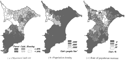
Figure 2 Maps by statistical data
Fig. 3 shows area percentage of land use against population density. In towns and villages which with under 1000 people/km2 in population density, forest and/or cultivated area is higher percentage and housing is under 320% . As population increases, forest and cultivated area decrease to under 20% and under 10% respectively, and housing area increase to about 50%. Fig.3 (d) shows percentage of land use against three element; housing, green area (forest and cultivated) and statistically unclassified area. It represents clearly the decrease of green area as the increase of population
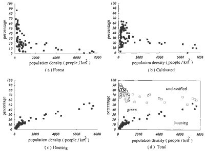
Figure 3 Land use percentage against population density
4. Land Use Mapping by LANDSAT TM Data
Land use maps are shown in Fig. 4 and Fig. 5. The accuracy of classification is poor, especially for cultivated, urban and golf course, because of similar spectral characteristics of these land use in winter images. Mean and standard deviation of these land use for each band are shown in fig 6 and Table 1. It is necessary for change detection to improve the land use map.
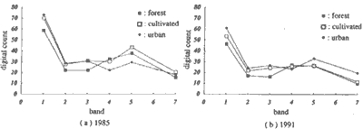
Figure 4 Mean of training area for each band (band 6 is not used)
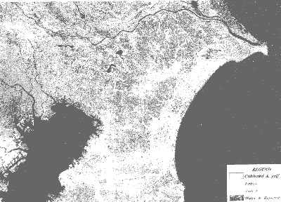
Figure 5 Land use classification map (1985)
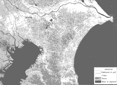
Figure 6 Land use classification map (1991)
Table 1 Standard deviation of training area for each for each band (band 6 is not used)
| 1985 | 1991 | |||||
| Band | Forest | Cultivated | Urban | Forest | Cultivated | Urban |
| 1 | 2.48 | 2.16 | 2.61 | 2.43 | 2.17 | 3.94 |
| 2 | 1.88 | 1.36 | 1.67 | 2.13 | 1.26 | 2.31 |
| 3 | 3.67 | 2.43 | 2.83 | 3.80 | 2.04 | 3.62 |
| 4 | 9.82 | 3.78 | 3.35 | 10.13 | 3.84 | 4.57 |
| 5 | 15.69 | 7.76 | 7.53 | 13.07 | 6.19 | 7.01 |
| 7 | 6.90 | 4.99 | 4.87 | 5.35 | 2.85 | 4.67 |
References
- Statistical yearbook in Chiba prefecture, 1990 the statistical section, the planning department, Chiba prefecture.
- Statistical yearbook in Chiba prefecture, 1985, the statistical section, the planning department, Chiba prefecture.
- Land use of Chiba prefecture, 1994, the planning section, the planning department, Chiba prefecture.