| GISdevelopment.net ---> AARS ---> ACRS 1994 ---> Poster Session |
Wasteland Mapping in Punjab
(India) using Remote Sensing Techniques
Rajiv Chopra, R. K. Litoria, A. Thomas and P. K. Sharma
Punjab Remote Sensing Centre P. A. U. Campus, Ludhiana - 141004
India
Rajiv Chopra, R. K. Litoria, A. Thomas and P. K. Sharma
Punjab Remote Sensing Centre P. A. U. Campus, Ludhiana - 141004
India
Abstract
The major area in Punjab, barring Siwalik hills, form a part of Indo-Gangetic alluvial plain in which low lying pockets are having the problems of water logging, soil salinity and/or alkalinity etc. The study deals with mapping of wastelands in three districts of the state namely Patiala, Jalandhar and Gurdaspur on 1:50,000 scale, through visual interpretation of IRS-1A LISS II data in the form of False Colour Composites (FCC). In all, nine categories of wastelands were mapped and major patches were checked in the field. In Patiala district, 18.85% of total geographical area is under various categories of wastelands, of which 4.47% is contributed by "sands-desertic and salinity/alkalinity (in-land)", where as in Jalandhar district, only 2.32% of the total geographical area is occupied by wastelands, of which 40.07% is contributed by sands-desertic". In Gurdaspur district, "under utilised/degraded notified forest area" followed by "water logged and marshy land" contribute 50.61% and 30.92% respectively of the total wasteland area in the district (24993ha) . The pu of the area under wastelands in the these districts need immediate attention and conservation for the optimum utilization of its capacity. Proper distribution of fertilizers, provision of proper drainage and leveling or the sand dunes are the major ameliorative measures to reclaim these wastelands.
1. Introduction
The state of Punjab is one of the most advanced agrarian states in India. Nearly 84% of total geographical area of the state is cultivated and any further increase in the area may only be possible by reclaiming various categories of degraded lands which have been rendered as wastelands. The major area in Punjab barring Siwalik hills forms part of Indo-Gangetic alluvial plain. Low lying pockets in the alluvial plain of Punjab are having the problem of water logging, soils salinity and/or alkalinity etc. (Sharma et al 1986).
Wasteland is the land which is degraded and is presently lying un-utilised (except follow) due to inherent or imposed disabilities related to location, environment, soil as well as current financial and management constraints (NRSA 1991). Information on geographical location, areal extent and spatial distribution of wastelands is essential for their effective management and sustainable development (Gautam and Narayan 1988). In view of this, mapping of wastelands in the three districts of Punjab viz. Patiala, Jalandhar and Gurdaspur have been carried out under the National Wasteland Mapping Project funded by Govt. of India through National Remote Sensing Agency, Hyderabad. The primary objective of this project is to bring all the wastelands under productive use in the country through a massive programme of afforestation, agriculture, and other economic use.
2. Study Area
The Punjab State has been divided into four drainage tracts viz. Upper Bari Doab tract, Bist-Doab tract, Ghaggar tract and Sirhind-Firozpur tract. Gurdashpur district forms a part of Upper Bari Doab tract with latitude 310 36' 13" & 320 32' 24" N and longitude 740 53' 30" & 750 56' 11" E where as Jalandhar district lies in Bist-Doab tract with latitude 300 38' 22" & 300 36' 41" N and longitude 750 05' 09" & 760 16' 16" E. Patiala district having latitude 290 47' & 300 47' N and longitude 750 56' & 760 56' E is part of Ghaggar tract. The mean annual influenced by the Himalayas in north and the desert in south and south-west. The mean annual rainfall varies from 300 mm to 1400 mm being highest in north-east and decrease gradually towards south-west. The mean monthly minimum temperature (January) is as low as 4.70C (Economic Advisor 1987-91) . The area is drained by three major rivers namely Ravi, Beas and Sutlej. The other main channels are Ghaggar, White Bein, Black Bein, Kiran Nala, Chakki River and Sakki Nala.
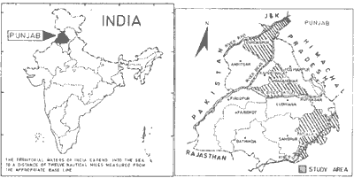
Figure 1 Location Map of Study Area
3 Methodology
For preparing wasteland maps on 1:50,000 scale, the IRS-1A LISS-II data in the from of False Colour Composites (FCC) generated from band 2, 3 & 4 was interpreted visually. The variation in the texture, shape, size and pattern were used to identify and delineate different wasteland categories. All the major patches of wastelands were physically verified. Other collateral data in the form of Survey of India Punjab) and other published reports were used for mapping different wasteland categories. The methodology and classification system use were according to the Manual of Instructions prepared by National Remote Sensing Agency, Hyderabad (NRSA) 1986). The final maps showing different wasteland categories on 1:59,000 scale with village boundaries, subwatershed boundaries and notified forest areas were prepared. The details of wasteland categories in Patiala, Jalandhar and Gurdaspur district marked on 1:50,000 scale were transferred on 1:250, scale maps for preparing single map for each district.
4. Results and Discussion
District wise wasteland maps on 1:250,000 scale for Patiala, Jalandhar and Gurdaspur districts have been prepared based on visual interpretation of FFCs with limited ground truth data. The various wasteland categories identified in the three districts have been discussed below briefly. The distribution of wastelands in parts of Patiala and Gurdaspur districts are shown in Fig. 2 and 3 respectively.
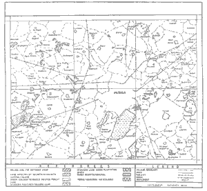
Figure 2 Wasteland Map (Part of Patiala District)

Figure 3 Wasteland Map of Part of Gurdaspur District
Gullied and/or ravinious land: This unit show a distnct light bluish green tone, irregular shape and etrenched drainage on the FCC. This category is found along the rivulets traversing the area in a zig-zag way.
Upland with/or without scrub: These lands appear in light yellow to dark yellow ton with reddish tinge on the FCC. It occurs along the choe banks. In this unit cultivated and uncultivated areas are interspersed. The area is either barren or occasionally/marginally cultivated.
Water logged or marsh land: These are distinctly seen in light to medium blue tone of varying sizes and shapes in the image. In these area, ground water level is high especially during mosoon/post mosoon months. Poor drainage, shallow ground water level and poor soil physical condition have rendered these patches as wasteland.
Land affected b salinity/alkalinity: Sat affected patches appear in different tones on FCC in different geographical situations. As these can be identified with white tone in alluvial plains where as it has light bluish tinge near canals. The severely salt affected soils are generally found in low lying areas within alluvial plain. The saline-sodic soils are the result of fluctuating ground water table, prolonged use of poor quality irrigation water and flooding. This category is mostly barren and wherever cultivated, yields much below their potential capacity.
Under utilized/degraded notified forest area: This unit appear in yellowish tone with regular to irregular shape, associated with forest land having reddish brown tone. Some of the notified forest areas are degraded having poor forest cover due to soil salinity, biotic interference and other factors.
Degraded pastures/grazing land: This unit exists in small patches having a white tone with red tinge on the satellite image. Most of such patches are either owned by Panchyates or land left for animal grazing. Such land is locally known as "Shamlat".
Sands-desertic: Sandy area appear in white to light yellow tone with a wavy pattern on the FCCs. South western winds have played a prominant role in their formation. This unit occurs as patches and has aligned itself along the predominant wind direction. Most of the dunes have been cleared/levelled for cultivation.
Degraded land under plantation crops: This unit has a light red tone. It occurs in patches and is affected by soil salinity.
Mining/industrial wasteland: This unit occurs in patches. It has a dirty white to greyish tone. Brick kilns and industrial waste disposal sites are the major contributors for rendering the otherwise fertile land as wasteland.
Areas of various categories of wastelands in three districts of the state have been computed and presented in Table 1. A perusal of the data in Table 1 indicates that in the Patiala district the percentage of total wasteland area to the geographical area was found to be 18.85%. of which 4.47% is contributed b land affected b salinity/alkalinity in-land (Chopra et al 1992). In Jalandhar, only 2.32% of the total geographical area of the district is occupied by wastelands, of which 40.07% was contributed by "Sands-desertic" (Chopra et al 1993a). In Gurdaspur district under utilised/degraded notified forest area followed b water logged and marshy land contribute 59.61% and 30.92% respectively of the total of 0.024% of wastelands to the total geographical area of the of the district (Chopra et al 1993b).
Table 1 Area of each category of wastelands in Patiala,
Jalandhar and Gurdaspur districts.
5. Conclusion
This study demonstrates the potentiality of satellite remote sensing technique for preparation of more consistent and accurate baseline information on wastelands. The spatial information on wastelands at the village level can be utilised for various reclamation measures and subsequent use under social forestry, agro-forestry, fuel and fodder, farm forestry and afforestation programme.
6. Recommendations
Punjab is one of the most developed states of the country. Still sizeable area is left as wastelands. With 84 per cent of the geographical area of the state under cultivation, of which 90 per cent is irrigated and a fertilizer consumption of 159 kg/ha of gross cropped area, a stage has been reached where further increase in agricultural production can be achieved only by improving the productivity of marginal land. The part of the area rendered wastelands in the three districts needs immediate attention and conservation for the optimum utilization of its capacity. Proper distribution of fertilizers, existence of proper drainage and levelling of the sand dunes are the major ameliorative measures to reclaim these wastelands.
Reference
The major area in Punjab, barring Siwalik hills, form a part of Indo-Gangetic alluvial plain in which low lying pockets are having the problems of water logging, soil salinity and/or alkalinity etc. The study deals with mapping of wastelands in three districts of the state namely Patiala, Jalandhar and Gurdaspur on 1:50,000 scale, through visual interpretation of IRS-1A LISS II data in the form of False Colour Composites (FCC). In all, nine categories of wastelands were mapped and major patches were checked in the field. In Patiala district, 18.85% of total geographical area is under various categories of wastelands, of which 4.47% is contributed by "sands-desertic and salinity/alkalinity (in-land)", where as in Jalandhar district, only 2.32% of the total geographical area is occupied by wastelands, of which 40.07% is contributed by sands-desertic". In Gurdaspur district, "under utilised/degraded notified forest area" followed by "water logged and marshy land" contribute 50.61% and 30.92% respectively of the total wasteland area in the district (24993ha) . The pu of the area under wastelands in the these districts need immediate attention and conservation for the optimum utilization of its capacity. Proper distribution of fertilizers, provision of proper drainage and leveling or the sand dunes are the major ameliorative measures to reclaim these wastelands.
1. Introduction
The state of Punjab is one of the most advanced agrarian states in India. Nearly 84% of total geographical area of the state is cultivated and any further increase in the area may only be possible by reclaiming various categories of degraded lands which have been rendered as wastelands. The major area in Punjab barring Siwalik hills forms part of Indo-Gangetic alluvial plain. Low lying pockets in the alluvial plain of Punjab are having the problem of water logging, soils salinity and/or alkalinity etc. (Sharma et al 1986).
Wasteland is the land which is degraded and is presently lying un-utilised (except follow) due to inherent or imposed disabilities related to location, environment, soil as well as current financial and management constraints (NRSA 1991). Information on geographical location, areal extent and spatial distribution of wastelands is essential for their effective management and sustainable development (Gautam and Narayan 1988). In view of this, mapping of wastelands in the three districts of Punjab viz. Patiala, Jalandhar and Gurdaspur have been carried out under the National Wasteland Mapping Project funded by Govt. of India through National Remote Sensing Agency, Hyderabad. The primary objective of this project is to bring all the wastelands under productive use in the country through a massive programme of afforestation, agriculture, and other economic use.
2. Study Area
The Punjab State has been divided into four drainage tracts viz. Upper Bari Doab tract, Bist-Doab tract, Ghaggar tract and Sirhind-Firozpur tract. Gurdashpur district forms a part of Upper Bari Doab tract with latitude 310 36' 13" & 320 32' 24" N and longitude 740 53' 30" & 750 56' 11" E where as Jalandhar district lies in Bist-Doab tract with latitude 300 38' 22" & 300 36' 41" N and longitude 750 05' 09" & 760 16' 16" E. Patiala district having latitude 290 47' & 300 47' N and longitude 750 56' & 760 56' E is part of Ghaggar tract. The mean annual influenced by the Himalayas in north and the desert in south and south-west. The mean annual rainfall varies from 300 mm to 1400 mm being highest in north-east and decrease gradually towards south-west. The mean monthly minimum temperature (January) is as low as 4.70C (Economic Advisor 1987-91) . The area is drained by three major rivers namely Ravi, Beas and Sutlej. The other main channels are Ghaggar, White Bein, Black Bein, Kiran Nala, Chakki River and Sakki Nala.
Figure 1 Location Map of Study Area
3 Methodology
For preparing wasteland maps on 1:50,000 scale, the IRS-1A LISS-II data in the from of False Colour Composites (FCC) generated from band 2, 3 & 4 was interpreted visually. The variation in the texture, shape, size and pattern were used to identify and delineate different wasteland categories. All the major patches of wastelands were physically verified. Other collateral data in the form of Survey of India Punjab) and other published reports were used for mapping different wasteland categories. The methodology and classification system use were according to the Manual of Instructions prepared by National Remote Sensing Agency, Hyderabad (NRSA) 1986). The final maps showing different wasteland categories on 1:59,000 scale with village boundaries, subwatershed boundaries and notified forest areas were prepared. The details of wasteland categories in Patiala, Jalandhar and Gurdaspur district marked on 1:50,000 scale were transferred on 1:250, scale maps for preparing single map for each district.
4. Results and Discussion
District wise wasteland maps on 1:250,000 scale for Patiala, Jalandhar and Gurdaspur districts have been prepared based on visual interpretation of FFCs with limited ground truth data. The various wasteland categories identified in the three districts have been discussed below briefly. The distribution of wastelands in parts of Patiala and Gurdaspur districts are shown in Fig. 2 and 3 respectively.
Figure 2 Wasteland Map (Part of Patiala District)
Figure 3 Wasteland Map of Part of Gurdaspur District
Gullied and/or ravinious land: This unit show a distnct light bluish green tone, irregular shape and etrenched drainage on the FCC. This category is found along the rivulets traversing the area in a zig-zag way.
Upland with/or without scrub: These lands appear in light yellow to dark yellow ton with reddish tinge on the FCC. It occurs along the choe banks. In this unit cultivated and uncultivated areas are interspersed. The area is either barren or occasionally/marginally cultivated.
Water logged or marsh land: These are distinctly seen in light to medium blue tone of varying sizes and shapes in the image. In these area, ground water level is high especially during mosoon/post mosoon months. Poor drainage, shallow ground water level and poor soil physical condition have rendered these patches as wasteland.
Land affected b salinity/alkalinity: Sat affected patches appear in different tones on FCC in different geographical situations. As these can be identified with white tone in alluvial plains where as it has light bluish tinge near canals. The severely salt affected soils are generally found in low lying areas within alluvial plain. The saline-sodic soils are the result of fluctuating ground water table, prolonged use of poor quality irrigation water and flooding. This category is mostly barren and wherever cultivated, yields much below their potential capacity.
Under utilized/degraded notified forest area: This unit appear in yellowish tone with regular to irregular shape, associated with forest land having reddish brown tone. Some of the notified forest areas are degraded having poor forest cover due to soil salinity, biotic interference and other factors.
Degraded pastures/grazing land: This unit exists in small patches having a white tone with red tinge on the satellite image. Most of such patches are either owned by Panchyates or land left for animal grazing. Such land is locally known as "Shamlat".
Sands-desertic: Sandy area appear in white to light yellow tone with a wavy pattern on the FCCs. South western winds have played a prominant role in their formation. This unit occurs as patches and has aligned itself along the predominant wind direction. Most of the dunes have been cleared/levelled for cultivation.
Degraded land under plantation crops: This unit has a light red tone. It occurs in patches and is affected by soil salinity.
Mining/industrial wasteland: This unit occurs in patches. It has a dirty white to greyish tone. Brick kilns and industrial waste disposal sites are the major contributors for rendering the otherwise fertile land as wasteland.
Areas of various categories of wastelands in three districts of the state have been computed and presented in Table 1. A perusal of the data in Table 1 indicates that in the Patiala district the percentage of total wasteland area to the geographical area was found to be 18.85%. of which 4.47% is contributed b land affected b salinity/alkalinity in-land (Chopra et al 1992). In Jalandhar, only 2.32% of the total geographical area of the district is occupied by wastelands, of which 40.07% was contributed by "Sands-desertic" (Chopra et al 1993a). In Gurdaspur district under utilised/degraded notified forest area followed b water logged and marshy land contribute 59.61% and 30.92% respectively of the total of 0.024% of wastelands to the total geographical area of the of the district (Chopra et al 1993b).
| Category | Area of wastelands in ha. | ||
| Patiala | Jalandhar | Gurdaspur | |
| 1. Gullied and/or ravinous land | 4801 | Nil | 1713 |
| 2. Upland with or without scrub | 0346 | 0064 | 0203 |
| 3. Water logged/ Marshy land | 8578 | 1256 | 7729 |
| 4. Land affected by Salinity/Alkalinity (In-land) | 3904 | 0147 | 1536 |
| 5. Under utilised/Degraded notified forest area | 22130 | 0065 | 12649 |
| 6. Degraded pastures/ Grazing land | 16839 | 0256 | 160 |
| 7. Sands-Desertic | 14079 | 3173 | 112 |
| 8. Degraded land under plantation crops | 13710 | 2795 | 876 |
| 9. Mining/Industrial wasteland | 2794 | 161 | 015 |
| Total area under wastelands | 87244 | 7917 | 24993 |
| Total geographical area of the district | 46280 | 341360 | 356200 |
| % of the total geographical area of the district under wastelands | 18.85 | 2.32 | 7.02 |
5. Conclusion
This study demonstrates the potentiality of satellite remote sensing technique for preparation of more consistent and accurate baseline information on wastelands. The spatial information on wastelands at the village level can be utilised for various reclamation measures and subsequent use under social forestry, agro-forestry, fuel and fodder, farm forestry and afforestation programme.
6. Recommendations
Punjab is one of the most developed states of the country. Still sizeable area is left as wastelands. With 84 per cent of the geographical area of the state under cultivation, of which 90 per cent is irrigated and a fertilizer consumption of 159 kg/ha of gross cropped area, a stage has been reached where further increase in agricultural production can be achieved only by improving the productivity of marginal land. The part of the area rendered wastelands in the three districts needs immediate attention and conservation for the optimum utilization of its capacity. Proper distribution of fertilizers, existence of proper drainage and levelling of the sand dunes are the major ameliorative measures to reclaim these wastelands.
Reference
- Chopra R., P.K. Litoria and A. Thomas (1992). Report on wastelands Patiala district, Punjab. Technical Report No. PUNSEN-TR-04-92, Punjab Remote Sensing Centre, Ludhiana (India).
- Chopra R., A. Thomas, P.K. Litoria and P.K. Sharma (1993a). Report on wastelands Jalandhar district, Punjab. Technical Report No. PUNSEN-TR-05-93, Punjab Remote Sensing Centre, Ludhiana (India).
- Chopra R., A. Thomas, PK. Litoria and P.K. Sharma (1993b). Report on wastelands Gurdaspur district, Punjab. Technical Report No. UNSEN-TR06-93, Punjab Remote Sensing Centre, Ludhiana (India).
- Economic Advisor (1987-91). Statistical Abstract of Punjab. Economic Advisor, Punjab Govt., Chandigarh.
- Gautam N.C. and L.R.A. Narayan (1988). Wastelands mapping in India. Pink publishing house, Mathua.
- NRSA (1986). Manual of procedures for wasteland mapping. National Remote Sensing Agency, Hyderabad.
- NRSA (1991). Guidelines to use wasteland maps. National Remote Sensing Agency, Hyderabad. 72 pp.
- Sharma P.K., J.L. Sehgal and K.R. Sharma (1986). Mapping of salt affected soils in Sangrur district (Punjab)- using aerial photo interpretation technique. Photonirvachak : J. Indian Soc. Remote Sensing, 4: 43-54.