| GISdevelopment.net ---> AARS ---> ACRS 1994 ---> Poster Session |
Application of Remote Sensing
in Spatial and Temporal Analysis of Coastal Wetland Vulnerability - A Case
Study on Samang Lake of Orissa
P. Kumar, M. K. Sanabada
and P. R. Mohanty
Orissa Remote Sensing Application Centre
Post Box - 119, Bhubaneswar - 751 001, India
Orissa Remote Sensing Application Centre
Post Box - 119, Bhubaneswar - 751 001, India
Abstract
The coastal wetlands have a significant role in our ecosystem. They have multiple use values which become obscured by wrong assessment or adoption of development measures. It has been long felt that integrated resource appraisal - in terms of spatial and temporal context, assessment and evaluation of various structural components of wetland system and suggestive use options are prime requisite for developing the wetland. Samang Lake near puri lying stage. Heavy silt deposition, growing urbanization and drainage routing etc make the lakes as a sink and vulnerable to a single landuse practice i.e agriculture. Multidate and multi platform data like 1973 and 1990 aerial photographs, Landsat-5 TM (FCC) of 1986 and IRS IB data of 1993 have been studied in generating various spatial information about the lake. Various landuse / landcover types have been delineated and analysed in terms of their geomorphic setup. Shrinkage of water spread area is also assessed from temporal data. Hydromorphological classification of the wetland is also attempted.
The study reveals potentially of pace/air borne data in resource appraisal of vulnerable wetlands and assessment of several variables of the structural elements of the lake. The growing agricultural practice and chocking due to urbanization and drainage routing are the major concern now and to be dealt with care while planning developmental measures.
Introduction
Depletion of wetland resources is a worldwide phenomenon and the growing concern to conserve them and establishing values on the vulnerable wetlands in respect of preservation, conservation, utilization or development purposes need continuous information in both historical and real time terms. Study on changes occurred due to natural anthropogenic causes is also very essential in detecting, recognizing and evaluating the linkages of the biotic and abiotic components. Keeping aside the advantages of the conventional data source, the remotely sensed data can be used to span temporal and spatial scales using multi sensor and multitemporal data sets. In the present study both aerial and space borne data have been used to present study both aerial and space borne data have been used to generate most of the thematic information in spatial and temporal context.
Study Area
Samang Lake of Orissa lies in the lower Mahanadi delta having latitudes 1900 49' to 190 52' N and longitude 850 47' to 850 51' E which is 1 km on the northern side of the Puri town and 3.5 km from the coast of Bay of Bengal. The lake is connected tot eh Bay of Bengal by a tidal outlet called Mangala nala. The area experiences a humid tropical climate. Interestingly the daily mean temperature of the area also rises from 26.890C (1936-40) to 27.270C (1981-85). Average annual rainfall recorded is around 1372.6mm at Puri.
Methodology
Data used :
Aerial photographs pertaining to 1973 adn1990 in 1:29, 000 and 1:8,000 scales and LANDST-5 TM (FCC) data(18.2.1986) as well as IRS IB LISS-II data (24.2.1993) have been studies in generating various spatial information about the lake. Survey of India topographic sheet (surveyed in 1972-73) is used as the base map.
Data analysis :
All the aerial as well as satellite data have been visually analysed using field validated interpretation key. Thematic information on geomorphology, hydrology, water spread and landuse types have been generated. Interpreted results were transferred to the base map and registered using the optical pantograph. Finally areas of different landuse units have been calculated.
Results and Discussion
Main features of the wetland :
Three controlling factors are mainly responsible for the existing set-up of the lake namely climate, topography and geology of the are. The modifying process is mainly due to anthropogenic activities.
Table 1 Main Features of ohe Wetland
Geomorphic setup :
Samang Lake lies in the lower deltaic flood plain Mahanadi river to which alluvium mostly supplied by the Bhrgavi river. Geomorphogically the study area can be divided into two geomorphic surfaces namely the Devi - Kushbhadra - Bhargavi deltaic surfaces (in which the lake lies) and the coastal Konark Surface (Puri town areas). These two plan action surfaces have discrete level difference between them. The Devi - Kushbhadra Bhargavi surface denotes a level more than 8.0 m to 2.5m (above MSL. The coastal surfaces are normally 1.5 m o 3.0 m higher than the deltaic surfaces (Ghosh and De 1984) and the formation of this area pertain to Quaternary period (2300 - 750 BP). Due to the aforesaid geomorphological setup the rivers run parallel to the coast along the beach ridges. The samang depression in the floor plain collects water from the rivulets of Bhargavi and finally discharges into the sea through Mangala nala.
Landuse/landcover change :
Landuse/landcover types have been delineated for the years 1973, 1986, 1990 and 1993. The change of waterspread area to reclaimed agriculture land is shown in table 2. It is interesting to note that the waterspread area becomes almost extinct from 1972-73 to 1993. The whole lake area has been converted to intensive agriculture fields. During rainy season the whole lake area becomes over flooded and cropping activities resumed only after flood recession. Construction of embankments surrounding the lake and along the river courses restrict the inflow of water from surface drains. The problem of drainage has become very acute due to low gradient of the valley long profiles (Sinha 19810. the encroachment of land is also due t the urban sprawl of puri town in the eastern and northern portions.
Table 2 Waterspread / Land Reclaimation in the Samang Lake
Hydromorphological classification :
Hydromorphologically the Samang Lake is classified as River / floor palim fen (intermediate) type (Goode 1977) as the water input to the wetland is mainly from rainfall, surface water and ground water. The lake can be described as "A" type as described by Lloyd et al (1993) considering the overbank flooding and low relief adjacent to river and the geology of the catchment.
Conclusion
Space and air borne data due to its synoptivity and flexibility in using various spectral and temporal data give ample advantages in assessing the several variables of a vulnerable wetland. The dossier of information can be valued in terms of characterizing and analyzing the c-existence of a wetland with impacting forces.
Reference
Location Map of Samang Lake

Map Showing Extent pf Samang Lake in 1972 - 73
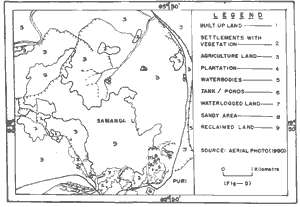
Landuse Landcover Map of Samang Lake Area (1990)
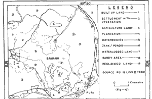
Landuse Landcover of Samang Lake Area (1993)

Landuse Landcover Map of Samang Lake Area (1973)
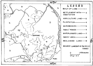
Landuse Landcover Map of Samang Lake Area (1986)
The coastal wetlands have a significant role in our ecosystem. They have multiple use values which become obscured by wrong assessment or adoption of development measures. It has been long felt that integrated resource appraisal - in terms of spatial and temporal context, assessment and evaluation of various structural components of wetland system and suggestive use options are prime requisite for developing the wetland. Samang Lake near puri lying stage. Heavy silt deposition, growing urbanization and drainage routing etc make the lakes as a sink and vulnerable to a single landuse practice i.e agriculture. Multidate and multi platform data like 1973 and 1990 aerial photographs, Landsat-5 TM (FCC) of 1986 and IRS IB data of 1993 have been studied in generating various spatial information about the lake. Various landuse / landcover types have been delineated and analysed in terms of their geomorphic setup. Shrinkage of water spread area is also assessed from temporal data. Hydromorphological classification of the wetland is also attempted.
The study reveals potentially of pace/air borne data in resource appraisal of vulnerable wetlands and assessment of several variables of the structural elements of the lake. The growing agricultural practice and chocking due to urbanization and drainage routing are the major concern now and to be dealt with care while planning developmental measures.
Introduction
Depletion of wetland resources is a worldwide phenomenon and the growing concern to conserve them and establishing values on the vulnerable wetlands in respect of preservation, conservation, utilization or development purposes need continuous information in both historical and real time terms. Study on changes occurred due to natural anthropogenic causes is also very essential in detecting, recognizing and evaluating the linkages of the biotic and abiotic components. Keeping aside the advantages of the conventional data source, the remotely sensed data can be used to span temporal and spatial scales using multi sensor and multitemporal data sets. In the present study both aerial and space borne data have been used to present study both aerial and space borne data have been used to generate most of the thematic information in spatial and temporal context.
Study Area
Samang Lake of Orissa lies in the lower Mahanadi delta having latitudes 1900 49' to 190 52' N and longitude 850 47' to 850 51' E which is 1 km on the northern side of the Puri town and 3.5 km from the coast of Bay of Bengal. The lake is connected tot eh Bay of Bengal by a tidal outlet called Mangala nala. The area experiences a humid tropical climate. Interestingly the daily mean temperature of the area also rises from 26.890C (1936-40) to 27.270C (1981-85). Average annual rainfall recorded is around 1372.6mm at Puri.
Methodology
Data used :
Aerial photographs pertaining to 1973 adn1990 in 1:29, 000 and 1:8,000 scales and LANDST-5 TM (FCC) data(18.2.1986) as well as IRS IB LISS-II data (24.2.1993) have been studies in generating various spatial information about the lake. Survey of India topographic sheet (surveyed in 1972-73) is used as the base map.
Data analysis :
All the aerial as well as satellite data have been visually analysed using field validated interpretation key. Thematic information on geomorphology, hydrology, water spread and landuse types have been generated. Interpreted results were transferred to the base map and registered using the optical pantograph. Finally areas of different landuse units have been calculated.
Results and Discussion
Main features of the wetland :
Three controlling factors are mainly responsible for the existing set-up of the lake namely climate, topography and geology of the are. The modifying process is mainly due to anthropogenic activities.
| Controlling factors | Modifying processes |
| Climate Surface water Evapotranspiration process Topography Flood plain - depression Size of the catchment area Energy of environment and rate of stream flow Geology Sedimentary fills Type of substratum | Man Land drainage River training Intensive cropping Urbanization Land conversation |
Geomorphic setup :
Samang Lake lies in the lower deltaic flood plain Mahanadi river to which alluvium mostly supplied by the Bhrgavi river. Geomorphogically the study area can be divided into two geomorphic surfaces namely the Devi - Kushbhadra - Bhargavi deltaic surfaces (in which the lake lies) and the coastal Konark Surface (Puri town areas). These two plan action surfaces have discrete level difference between them. The Devi - Kushbhadra Bhargavi surface denotes a level more than 8.0 m to 2.5m (above MSL. The coastal surfaces are normally 1.5 m o 3.0 m higher than the deltaic surfaces (Ghosh and De 1984) and the formation of this area pertain to Quaternary period (2300 - 750 BP). Due to the aforesaid geomorphological setup the rivers run parallel to the coast along the beach ridges. The samang depression in the floor plain collects water from the rivulets of Bhargavi and finally discharges into the sea through Mangala nala.
Landuse/landcover change :
Landuse/landcover types have been delineated for the years 1973, 1986, 1990 and 1993. The change of waterspread area to reclaimed agriculture land is shown in table 2. It is interesting to note that the waterspread area becomes almost extinct from 1972-73 to 1993. The whole lake area has been converted to intensive agriculture fields. During rainy season the whole lake area becomes over flooded and cropping activities resumed only after flood recession. Construction of embankments surrounding the lake and along the river courses restrict the inflow of water from surface drains. The problem of drainage has become very acute due to low gradient of the valley long profiles (Sinha 19810. the encroachment of land is also due t the urban sprawl of puri town in the eastern and northern portions.
| Year | Source | Waterspread area(Sq.km) | Agriculture land (Sq.km) |
| 1972-73 | SOI Toposheet | 5.57 | - |
| 1973 | Aerial photo | 3.67 | 6.68 |
| 1986 | Landsat - 5 | 1.16 | 6.71 |
| 1990 | Aerial photo | 0.17 | 7.85 |
| 1993 | IRS 1B | 1.28 | 6.81 |
Hydromorphological classification :
Hydromorphologically the Samang Lake is classified as River / floor palim fen (intermediate) type (Goode 1977) as the water input to the wetland is mainly from rainfall, surface water and ground water. The lake can be described as "A" type as described by Lloyd et al (1993) considering the overbank flooding and low relief adjacent to river and the geology of the catchment.
Conclusion
Space and air borne data due to its synoptivity and flexibility in using various spectral and temporal data give ample advantages in assessing the several variables of a vulnerable wetland. The dossier of information can be valued in terms of characterizing and analyzing the c-existence of a wetland with impacting forces.
Reference
- Ghosh R.N and De s K (1984) Geomorphic appraisal of environmental management of coastal areas : a case study of lower Mahandi delta, /Orissa Indian Minerals, Vol. 38, No. 3, 1984 pp. 36-53.
- Goode D (1977) Peatlands. A Nature Conservation Review Vol 1 (D.A Ractiliffe,ed), Cambridge University Press pp. 36-53.
- Lloyd J W, Tellam J H, Rukin N and Lerner D N (1993) Wetland vulnerability in East Anglia : a possible conceptual framework and generalized approach. Journal of environmental management (1993) 37 pp 87-102
- Sinha B N (1981) Geography of Orissa, N B T, India, New Delhi.
Location Map of Samang Lake
Map Showing Extent pf Samang Lake in 1972 - 73
Landuse Landcover Map of Samang Lake Area (1990)
Landuse Landcover of Samang Lake Area (1993)
Landuse Landcover Map of Samang Lake Area (1973)
Landuse Landcover Map of Samang Lake Area (1986)