| GISdevelopment.net ---> AARS ---> ACRS 1994 ---> Poster Session |
Mapping of Bara Shigri
Glacier, H. P. using Digital Image Processing Techniques
A. Jeyaram, Y. V. N.
Krishna Murthy and D. S. Srinivasan
Regional Remote Sensing Service Centre
Department of Space, Nagpur 440 010 - India
Regional Remote Sensing Service Centre
Department of Space, Nagpur 440 010 - India
Abstract
Glacier are perennial source for more than 19 rivers which flow from lofty mountain ranges of Himalaya in North India. These glaciers act as buffers with a regulated runoff in the rivers. The runoff from the glaciers in any part of the year may be less but collectively for a year may be less but collectively for a year may be more than that of the years precipitation. With the threat of global warming looming large, scientists across the world are trying to study the impact of the warmer earth on glacier system. Since the glaciers are mostly found inaccessible and in rugged terrain in the Himalayas, the use of remotely sensed data plays a crucial role by providing synoptic view in multispectral mode. different wave length bands are sensitive to the varying properties of lice/snow. The area covering Bara Shigri glacier forming part of Chandra Basin, Himachal Pradesh, has been made to map the major glacial features using digital techniques and assessed the application potential of IRS LISS II data for glacial mapping on an operational basis.
The change in the digital number (DN Value) of IRS data long the glacier transect from snout area to accumulation area have been analysed. Various digital image processing techniques have been carried out to delineate glacier boundary, accumulation area, equilibrium line, ablation area etc. The image ratio techniques provided major glacier units. The digital elevation model (DM) has been generated and false colour composite of band 4,3,2 and colour coded ratio output have been draped over DEM. Te mapping of the major glacier features are not clearly discernible in the FCC of IRS LISS II data probably due to 7 bits quantization level which due to 7 bits quantization level which shows mils change in gradient of DN values from accumulation zone to ablation zone. The rationing techniques of appropriate bands enhanced glacier features bands enhanced glacier feature which could be mapped easily.
The generation of digital terrain model (DTM) by draping colour coded ratio output and false colour composite provided new dimension for glacier mapping by delineation of glacier units and superimposition of selective contour over the glacier, permitted the correlation of elevation with glacier features.
Introduction
The surface of the glacier receives mass as snow and losses by ablation. The hydrologic characteristic of the glacier, its thickness, volute, mass balance, nature, rate of movement and response to climate change are the primary interest of glaciologist and hydrologists. Glaciers are found in the high altitudes of Himalayan ranges in India which from the perennial source for most of the north Indian rivers. The data compiled from 1812 by Mayewski and Jeschaka (1979) on the glacier history of high Asia indicate a peak position of the glacier during the year 1850 and a general state of retreat from that time. The pindari glacier in Kumaon region has retreated by over 2.6 km since 1958. The Garhwal Himalayas have some of the longest glaciers such as Gangotri in which the snout has retreated by 1100 m. Bara shigri and Chota Shigri glaciers of Himachal Pradesh have shrunk by 1 to 1.5 km 1850.
Since the glaciers are mostly found inaccessible in rugged terrain of Himalayas, the remotely sensed data plays a crucial role by not only providing synoptic view but also provides information in various wavelength ranges to study the glaciers in details. Ice/snow are easily discernible from the satellite images in the optical range. Different wavelength bands are sensitive to the varying properties of ice/snow.
Sutdy Area
The area covering Bara Shigri glacier in Hiamchal Pradesh, north India in bounded by latitudes of 320, 05' - 320 20' N and longitudes 770 28' - 770 - i) has been taken for digital image processing. Bara Shigri glacier form part of Chandra river basin. The elevation is ranging from 3800 m above MSL to 6637 m above MSL and the entire catchments is oriented towards ESE NNW direction. Fairly good vegetation is found in lower altitudes of the study area which extends as bushes in the higher altitudes. During winter, entire in summer close to 50% of the are a becomes snow free. The entire area is divided into 5 elevation zones.
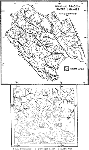
Figure 1 Location Map
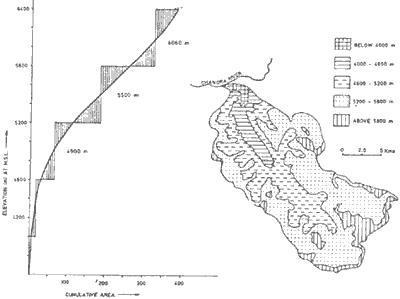
Figure 2 Altitude Zones and Mean Hypsometric Zones
Data Inputs
The following data are used for the present investigation :
The area covering Bara Shigri Glacier has been extracted from IRS LISS II digital data and processed for glacial mapping. IRS LISS II data has been geocoded using topographical maps. Band 4 has been scaled from0-127 to 0-255 by linear enhancement technique. The enhanced band 4 has been used for rationing with band 2. The resultatnt image is colour coded for various glacier features. The digital elevation model ahs been generated using SOI topographical map. False colour composite and the ratio images are subsequently raped on the DTM for further analysis. The digital rerrain model of rationed image ha been used for correlation of elevation with different glacial features.

Figure 3 Flow Chart of Methodology
Results
Digital Image Analysis
i) Spectral Properties
The radiance value along a transect of glacier have been calculated and plotted glacier pixel location fro snout area. This shows distinct variation of glacier features in band 4 and band 2 than the other bands.
The four bands of IRS LISS II data are studies in details specifically the histograms of the DN values. IRS LISS II is seven bit quantization level where the DN values are ranging from 0-127. in General, band 1 is affected by atmospheric scattering. The careful examination of radiance plot along a transect from snout to ablation area of glacier from snout to ablation are of the glacier indicate that band 2 and band 4 snow variation of different glacial ice. The false colour composite of band 4 in red, band 3 in green and band 2 in blue indicate that bluish colour in the snout area is due to the glacial melt. The clear demarcation of ablation zone and accumulation zone are not clearly discernible in the false colour composite.
ii) Image Rationing
IRS LSS II band 2 and band 4 have been selected for rationing based on the DN value and radiance analysis along a glacial transect. The variation of DN values of different glacial features are very less. Because of 7 bit different glacial features is not discernible clearly in the ration of band 2/band . The band 4 has been enhanced using linear stretch based on the histogram and the image has been transformed to 8 bit information (0-255). The enhanced band 4 and band 2 have been used as Normalised Difference Glacial Index (NDGI).
The ratio output enhanced different glacial features, density slicing and colour look up table are generated depicting different glacial features in the DNGI image and areal statistics are calculated.
iii) Digital Terrain Model
The height contours and spot heights from survey of India toposheets have been digitized. The height values are interpolated for entire part of the area and Digital Elevation Model (DEM) has been generated using the software available with Regional remote Sensing Service Centre. The false colour composite of band 4 in red, band 3 in green and band 3 in blue has been draped over DEM. Similarly, the colour coded NDGI image has been draped over DEM. The altitude variation of different glacial features are also studied.
Discussion
The outputs generated using digital image processing techniques have been interpreted for various glacial features, bara shigri glacier is a compound glacier where more tributary glaciers are joining the main valley. The entire glacial watershed area has been studied and mapped for glacial features.
i) Accumulation Zone
the accumulation zone form the upper part of the glacier which has net mass gain each year. The accumulation zone is clearly seen best at the end of the summer melting season. It has brightest tone in all the spectral bands of IRS LISS II data. The accumulation zone is totally frozen ground with smooth surface. The upper accumulation zones features like bergschrund (tension cracks), firm are not clearly discernible in IRS LISS II data. In the lower part of the accumulation zone, crevasses are also no discernible due to their dimension and are commonly concealed by snow bridges. The extent of accumulation zones differentiated better in eh ratio image (NDGI).
ii) Equilibrium Line
The line separating accumulation zone and ablation zone, is the equilibrium lie. The equilibrium line is not clearly discernible in the false colour composite. The false colour composite with the histogram equilised stretch of band 4 in red, band 3 in green ad band 2 in blue show ablation zone and accumulation zone. The expedition carried out by WIHG in Chota Shigri Glacier Indicate that Equilibrium Line Altitude (ELA) is 4400 mts above MSL. The ELA in Chota Shigri glacier has been verified in normalized difference Glacial Index (NDGI) image. The ELA in Bara Shigri main glacier is found to be 5200 Mts above MSL. The mild variation of ELA in different small glaciers of the Bara Shigri glacial complex has been observed.
iii) Ablation zone
The ablation zone form the lower part of the glacier where net loss of mass is prominent. The lowest part of ablation zone is terminus where the ice is mixed with moraines. A ice mixed with moraines in the snout area is clearly discernible in Fig 4. The pattern in the snout area indicate that this glacier is fast receding.
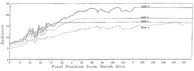
Figure 4 Spectral Properties of Bara Shigri Glacier
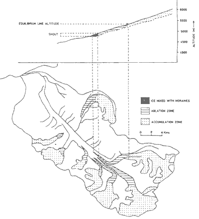
Figure 5 Bara Shigri Glacier
iv) Mass Balance
The mass balance of the glacier can be determined accurately by field measurements of the accumulation zone measurements of the accumulation zone and ablation zone. The position of transition snow line at the end of the melting snow line at the end of the melting season becomes a useful indicator of the mass balance. A correlation exist between altitude of the transient snow line and the annual specific net balance. The long term trend of the mass balance of no surging glaciers can be judged qualitatively from the characteristics of the lower ablation zone. In the Bara Shigri glacier complex no surging behaviour is observed. The sharp pointing edge f the terminus, high ice cored lateral moraines of the Bara Shigri glacier is indicative of negative mass balance.
Conclusion
At the end of summer period, the transient snow line moves in the higher altitude and the glaciers would be exposed. The end of the September and October months are suitable for studying the glaciers using satellite data. The hybrid approach of digital enhancements of IRS data with elevation model can be used on operational made of glacial mapping.
Acknowledgements
The authors express their deep sense of gratitude to Shri K. Radhakrishnan, Director NNRMS-RRSSC for his support and constant encouragement. Thanks to scientist of RRSSC, Nagpur, who had participated in scientific discussions.
References
Glacier are perennial source for more than 19 rivers which flow from lofty mountain ranges of Himalaya in North India. These glaciers act as buffers with a regulated runoff in the rivers. The runoff from the glaciers in any part of the year may be less but collectively for a year may be less but collectively for a year may be more than that of the years precipitation. With the threat of global warming looming large, scientists across the world are trying to study the impact of the warmer earth on glacier system. Since the glaciers are mostly found inaccessible and in rugged terrain in the Himalayas, the use of remotely sensed data plays a crucial role by providing synoptic view in multispectral mode. different wave length bands are sensitive to the varying properties of lice/snow. The area covering Bara Shigri glacier forming part of Chandra Basin, Himachal Pradesh, has been made to map the major glacial features using digital techniques and assessed the application potential of IRS LISS II data for glacial mapping on an operational basis.
The change in the digital number (DN Value) of IRS data long the glacier transect from snout area to accumulation area have been analysed. Various digital image processing techniques have been carried out to delineate glacier boundary, accumulation area, equilibrium line, ablation area etc. The image ratio techniques provided major glacier units. The digital elevation model (DM) has been generated and false colour composite of band 4,3,2 and colour coded ratio output have been draped over DEM. Te mapping of the major glacier features are not clearly discernible in the FCC of IRS LISS II data probably due to 7 bits quantization level which due to 7 bits quantization level which shows mils change in gradient of DN values from accumulation zone to ablation zone. The rationing techniques of appropriate bands enhanced glacier features bands enhanced glacier feature which could be mapped easily.
The generation of digital terrain model (DTM) by draping colour coded ratio output and false colour composite provided new dimension for glacier mapping by delineation of glacier units and superimposition of selective contour over the glacier, permitted the correlation of elevation with glacier features.
Introduction
The surface of the glacier receives mass as snow and losses by ablation. The hydrologic characteristic of the glacier, its thickness, volute, mass balance, nature, rate of movement and response to climate change are the primary interest of glaciologist and hydrologists. Glaciers are found in the high altitudes of Himalayan ranges in India which from the perennial source for most of the north Indian rivers. The data compiled from 1812 by Mayewski and Jeschaka (1979) on the glacier history of high Asia indicate a peak position of the glacier during the year 1850 and a general state of retreat from that time. The pindari glacier in Kumaon region has retreated by over 2.6 km since 1958. The Garhwal Himalayas have some of the longest glaciers such as Gangotri in which the snout has retreated by 1100 m. Bara shigri and Chota Shigri glaciers of Himachal Pradesh have shrunk by 1 to 1.5 km 1850.
Since the glaciers are mostly found inaccessible in rugged terrain of Himalayas, the remotely sensed data plays a crucial role by not only providing synoptic view but also provides information in various wavelength ranges to study the glaciers in details. Ice/snow are easily discernible from the satellite images in the optical range. Different wavelength bands are sensitive to the varying properties of ice/snow.
Sutdy Area
The area covering Bara Shigri glacier in Hiamchal Pradesh, north India in bounded by latitudes of 320, 05' - 320 20' N and longitudes 770 28' - 770 - i) has been taken for digital image processing. Bara Shigri glacier form part of Chandra river basin. The elevation is ranging from 3800 m above MSL to 6637 m above MSL and the entire catchments is oriented towards ESE NNW direction. Fairly good vegetation is found in lower altitudes of the study area which extends as bushes in the higher altitudes. During winter, entire in summer close to 50% of the are a becomes snow free. The entire area is divided into 5 elevation zones.
Figure 1 Location Map
Figure 2 Altitude Zones and Mean Hypsometric Zones
Data Inputs
The following data are used for the present investigation :
- Satellite data
IRS LISS II Path : 29 Row : 45 Q:A1 acquire on 21.09.1992. - Topographical map
52 H (1:2, 50,00 scale)
52 H/12, H/16, (1:50,000 scale)
The area covering Bara Shigri Glacier has been extracted from IRS LISS II digital data and processed for glacial mapping. IRS LISS II data has been geocoded using topographical maps. Band 4 has been scaled from0-127 to 0-255 by linear enhancement technique. The enhanced band 4 has been used for rationing with band 2. The resultatnt image is colour coded for various glacier features. The digital elevation model ahs been generated using SOI topographical map. False colour composite and the ratio images are subsequently raped on the DTM for further analysis. The digital rerrain model of rationed image ha been used for correlation of elevation with different glacial features.
Figure 3 Flow Chart of Methodology
Results
Digital Image Analysis
i) Spectral Properties
The radiance value along a transect of glacier have been calculated and plotted glacier pixel location fro snout area. This shows distinct variation of glacier features in band 4 and band 2 than the other bands.
The four bands of IRS LISS II data are studies in details specifically the histograms of the DN values. IRS LISS II is seven bit quantization level where the DN values are ranging from 0-127. in General, band 1 is affected by atmospheric scattering. The careful examination of radiance plot along a transect from snout to ablation area of glacier from snout to ablation are of the glacier indicate that band 2 and band 4 snow variation of different glacial ice. The false colour composite of band 4 in red, band 3 in green and band 2 in blue indicate that bluish colour in the snout area is due to the glacial melt. The clear demarcation of ablation zone and accumulation zone are not clearly discernible in the false colour composite.
ii) Image Rationing
IRS LSS II band 2 and band 4 have been selected for rationing based on the DN value and radiance analysis along a glacial transect. The variation of DN values of different glacial features are very less. Because of 7 bit different glacial features is not discernible clearly in the ration of band 2/band . The band 4 has been enhanced using linear stretch based on the histogram and the image has been transformed to 8 bit information (0-255). The enhanced band 4 and band 2 have been used as Normalised Difference Glacial Index (NDGI).
| NDGI = | Band 4 - Band
2 -------------------- Band 4 + Band 2 |
The ratio output enhanced different glacial features, density slicing and colour look up table are generated depicting different glacial features in the DNGI image and areal statistics are calculated.
iii) Digital Terrain Model
The height contours and spot heights from survey of India toposheets have been digitized. The height values are interpolated for entire part of the area and Digital Elevation Model (DEM) has been generated using the software available with Regional remote Sensing Service Centre. The false colour composite of band 4 in red, band 3 in green and band 3 in blue has been draped over DEM. Similarly, the colour coded NDGI image has been draped over DEM. The altitude variation of different glacial features are also studied.
Discussion
The outputs generated using digital image processing techniques have been interpreted for various glacial features, bara shigri glacier is a compound glacier where more tributary glaciers are joining the main valley. The entire glacial watershed area has been studied and mapped for glacial features.
i) Accumulation Zone
the accumulation zone form the upper part of the glacier which has net mass gain each year. The accumulation zone is clearly seen best at the end of the summer melting season. It has brightest tone in all the spectral bands of IRS LISS II data. The accumulation zone is totally frozen ground with smooth surface. The upper accumulation zones features like bergschrund (tension cracks), firm are not clearly discernible in IRS LISS II data. In the lower part of the accumulation zone, crevasses are also no discernible due to their dimension and are commonly concealed by snow bridges. The extent of accumulation zones differentiated better in eh ratio image (NDGI).
ii) Equilibrium Line
The line separating accumulation zone and ablation zone, is the equilibrium lie. The equilibrium line is not clearly discernible in the false colour composite. The false colour composite with the histogram equilised stretch of band 4 in red, band 3 in green ad band 2 in blue show ablation zone and accumulation zone. The expedition carried out by WIHG in Chota Shigri Glacier Indicate that Equilibrium Line Altitude (ELA) is 4400 mts above MSL. The ELA in Chota Shigri glacier has been verified in normalized difference Glacial Index (NDGI) image. The ELA in Bara Shigri main glacier is found to be 5200 Mts above MSL. The mild variation of ELA in different small glaciers of the Bara Shigri glacial complex has been observed.
iii) Ablation zone
The ablation zone form the lower part of the glacier where net loss of mass is prominent. The lowest part of ablation zone is terminus where the ice is mixed with moraines. A ice mixed with moraines in the snout area is clearly discernible in Fig 4. The pattern in the snout area indicate that this glacier is fast receding.
Figure 4 Spectral Properties of Bara Shigri Glacier
Figure 5 Bara Shigri Glacier
iv) Mass Balance
The mass balance of the glacier can be determined accurately by field measurements of the accumulation zone measurements of the accumulation zone and ablation zone. The position of transition snow line at the end of the melting snow line at the end of the melting season becomes a useful indicator of the mass balance. A correlation exist between altitude of the transient snow line and the annual specific net balance. The long term trend of the mass balance of no surging glaciers can be judged qualitatively from the characteristics of the lower ablation zone. In the Bara Shigri glacier complex no surging behaviour is observed. The sharp pointing edge f the terminus, high ice cored lateral moraines of the Bara Shigri glacier is indicative of negative mass balance.
Conclusion
At the end of summer period, the transient snow line moves in the higher altitude and the glaciers would be exposed. The end of the September and October months are suitable for studying the glaciers using satellite data. The hybrid approach of digital enhancements of IRS data with elevation model can be used on operational made of glacial mapping.
Acknowledgements
The authors express their deep sense of gratitude to Shri K. Radhakrishnan, Director NNRMS-RRSSC for his support and constant encouragement. Thanks to scientist of RRSSC, Nagpur, who had participated in scientific discussions.
References
- John A. Elson, glacial Geology, Remote Sensing in Geology, edited by Barly S. Siegal & alan e. Gillepie.
- Mayewsk, P.A and Jesahake, P.A (1979) Himalayan and Trns-Himalayan and glacier fluctuation since A.D 1812. Arctic and Alphien research 11 (3)
- Rawat B. R. S., Anil K. Mundepi and Surendra Kumar (1989), Mass balance, Surface lowering, velocity pattern and variation in Chota districts (H. P.), National Meet on Himalayan Glaciology, 5-6, June 1989.