| GISdevelopment.net ---> AARS ---> ACRS 1994 ---> Poster Session |
Multithematic Study for Water
Management and Selection of Water Conservation Sites using Integrated
Remote Sensing Technique in Tahsil, Mandsaur District, M. P.
T. Habib, S. Goyal, N. K.
Sharma and S. N. Rajak
India
India
Introduction
Water in the bio hydrosphere is an extremely finite but replenishible resource . the variable behaviour of ground water movement and occurrence in the hard rock areas and consequent recurrence of monsoon failure together with rising demand of water resources due to modern development and growing population pressure disturbs the equilibrium of optimal recharge conditions of water resources. The growing incompatibility between the supply in terms of availability and demand of water have necessitated and pressurized the scientists to adopt a more systematic and integrated scientific approach for sustainable development and management of water resources. The emerging scenario demands the quick and cost effective measures to gather the informations on various related aspects. Remote sensing has proved its effectiveness in generating detailed parameters required for suggesting action plan in this regard on sustainable basis.
The conjunctive use of surface and ground water and augmenting sub surface water storage is the answer to cope up with such conditions. Manasa tehsil of Mandsaur district is facing acute shortage of water resources and regular depleting trend of water table. If is, therefore, imperative that surface water storage should be created for checking the outflow of surface run of and catering the need of local population. At places where strata is capable of getting recharged needs construction of artificial recharge structures. The study suggests the suitable areas for both the purposes.
Study Area
Manasa Tahsil of Mandsaur district in Madhya Pradesh has been chosen for the study; keeping in view that the area is suffering from acute scarcity of potable water and depletion of water table. The area under the tahsil boundary has been selected considering that the developmental activities can be effectively and efficiently taken up from the administrative view point. The study area lies between longitude 75001' to 750'35' E and latitude 240019 and 240;43' N falling in survey of India (SOI) topographical sheet No. 45 P covering a total geographical area of about 1500 sq. kms
Physiographically, the northern part of study are is highly undulgatory and at places flat whereas southern part varies from moderately undulating to vast flat terrain, depicting dominance of extensive erosion of Deccan Trap basalts.
Materials & Methodology
Landsat TM FCC imagery of January, 1986 and IRS LISS-II data of November, 1992 and February 1993 have been used to extract the various thematic details. The SOI topographical map No. 45 P/2, P/3, P/6, P/7, P/10 and P/11 were used for taking base informations. Besides, published and reports were also consulted.
The satellite data was visually interpreted to delineate the thematic informations related to Geology, Geomorphology, Landuse/Land Cover, Geological structures like lineaments etc. The interpreted thematic details are transferred on to the base map. Various thematic informatiosn were integrated and finally dam sites suitable/ for surface water storage and artificial recharge structures were identified considering the proximity to the habitation, as a prime factor to cater the needs of the local people and also recharge the aquifer in that vicinity.
Results and Discussions
The informations extracted through visual interpretation of the satellite data are described below:-
Rocks in the study area belong to the Vindhyan Supergroup and Deccan Traps. Northern most part s occupied by Kaimur sandstone and shales of Upper Vindhyans whereas the Central part is occupied by Semri shales of lower Vindhyans of Pre-Cmabrian age. The southern part of the area is occupied by Deccan Trap basalt of Upper cretaceous to Eocene age.
Kaimur sandstones are compact and massive. Fractures and joints have developed secondary porosity in Kaimurs. They are also intercalated with shales, which are fragile and soft in nature. Kaimurs are dipping gently fro 50 to 100 towards NNW. Kaimurs appear light pink to reddish brown in colour on the imagery due to scantly vegetation grown over these rocks. Semri shales are sub horizontally disposed.
The Deccan Trap basalts are covering a large geographical area. They are highly weathered and have relatively good secondary porosity developed due to cooling joints and fractures. The basaltic exposure appears light grayish in colour on the imagery.
Geomorphologically, the area can be divided in three distinct genetic types of landforms viz. landforms of fluvial origin, landforms of denudational origin and landforms of structural origin. The sandstones being more resistant are forming cuestas with cuestaslopes alongwith structural valleys. The basalt of compact and massive nature are forming plateau. Landforms of denudational origin such as pediment, buried pediplain and eudational valleys are developed at places where the rocks are subjected t the differential erosion and other denudational processes. In between these long narrow fluvial valleys forming the valley fills which are considered to be potential areas for accumulation and movement of the groundwater.
The study are falls in Chambal river watershed. Its main tributaried flowing in the area are Indar, Ratem, Phalku etc.
The drainage pattern in general but at places they are structurally controlled. The river Idar is flowing more or less straight, which predicts to be following a major lineament. In the northern part drainages are flowing towards NNE whereas in southern part they are flowing towards SE following the local slope direction. Gandhi sagar reservoir constructed over champal river located on the eastern boundary is a multipurpose reservoir,
The status of landuse/land cover has been mapped to assess the present scenario. The major categories occurring in Manasa tahsil area (a) Built-up land (11.5 sq. km0; (b) Agricultural Land - Rabi Crop area (9.975 sq. km), kharif crop area (102.075 sq.km), Double corp area (522.25 sq. km); (c) Forest land - Deciduous Forest (175,.75 sq. km), Degarded Forest (4.25 sq. km); (d) Wastelands - Gullied/Ravineous land (30.25 sq.km) land with or without scrub (84.825 sq. km), Barren Rocky/Stony waste (463.47 sq. km) and (e) Waterbodies (112.25 sq. km). The development and management of water resources in Manasa Tahsil may help in improving the prevailing practices of agricultural activities and other marginal land.
Based on the integration of Geology, Geomorphology, Landuse/Land cover topography, Drainage and Lineaments, a total number of thirty six sites have been identified for surface water storage and artificial recharge structures(Plate 1)
The sites which have been suggested for surface water storage are identified at places where sufficient catchments is available to contribute surface run-off and the dam is capable of creating surface reservoir. These sites may act as the check dams also despite their main purpose of water supply from surface sources.
Table 1
Conclusion
The study reveals that remote sensing technique is highly effective in generating timely and reliable informations on various themes required to take stock of natural resources and other associated details for suggesting suitable sites for water harvesting. The sites suggested for creating surface water reservoir and constructing artificial recharge structures will not only check the erosional activities but also cater the needs of local population and help in recharging the near surface aquifers.
Acknowledgement
The authors are thankful to Dr. R.K Singh, Incharge, Remote Sensing Applications Centre, Bhopal for extending facilities to conduct this study. Dr. D.K Pandey and Shri P. Kavishwar are also thankfully acknowledged for encouragement and constructive criticisms in improving the work. Ku. Sunita Daniel is also acknowledged for typing the manuscript.
References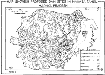
Map Showing Proposed Dam Sites in Manasa Tahsil - Madhya Pradesh
Water in the bio hydrosphere is an extremely finite but replenishible resource . the variable behaviour of ground water movement and occurrence in the hard rock areas and consequent recurrence of monsoon failure together with rising demand of water resources due to modern development and growing population pressure disturbs the equilibrium of optimal recharge conditions of water resources. The growing incompatibility between the supply in terms of availability and demand of water have necessitated and pressurized the scientists to adopt a more systematic and integrated scientific approach for sustainable development and management of water resources. The emerging scenario demands the quick and cost effective measures to gather the informations on various related aspects. Remote sensing has proved its effectiveness in generating detailed parameters required for suggesting action plan in this regard on sustainable basis.
The conjunctive use of surface and ground water and augmenting sub surface water storage is the answer to cope up with such conditions. Manasa tehsil of Mandsaur district is facing acute shortage of water resources and regular depleting trend of water table. If is, therefore, imperative that surface water storage should be created for checking the outflow of surface run of and catering the need of local population. At places where strata is capable of getting recharged needs construction of artificial recharge structures. The study suggests the suitable areas for both the purposes.
Study Area
Manasa Tahsil of Mandsaur district in Madhya Pradesh has been chosen for the study; keeping in view that the area is suffering from acute scarcity of potable water and depletion of water table. The area under the tahsil boundary has been selected considering that the developmental activities can be effectively and efficiently taken up from the administrative view point. The study area lies between longitude 75001' to 750'35' E and latitude 240019 and 240;43' N falling in survey of India (SOI) topographical sheet No. 45 P covering a total geographical area of about 1500 sq. kms
Physiographically, the northern part of study are is highly undulgatory and at places flat whereas southern part varies from moderately undulating to vast flat terrain, depicting dominance of extensive erosion of Deccan Trap basalts.
Materials & Methodology
Landsat TM FCC imagery of January, 1986 and IRS LISS-II data of November, 1992 and February 1993 have been used to extract the various thematic details. The SOI topographical map No. 45 P/2, P/3, P/6, P/7, P/10 and P/11 were used for taking base informations. Besides, published and reports were also consulted.
The satellite data was visually interpreted to delineate the thematic informations related to Geology, Geomorphology, Landuse/Land Cover, Geological structures like lineaments etc. The interpreted thematic details are transferred on to the base map. Various thematic informatiosn were integrated and finally dam sites suitable/ for surface water storage and artificial recharge structures were identified considering the proximity to the habitation, as a prime factor to cater the needs of the local people and also recharge the aquifer in that vicinity.
Results and Discussions
The informations extracted through visual interpretation of the satellite data are described below:-
Rocks in the study area belong to the Vindhyan Supergroup and Deccan Traps. Northern most part s occupied by Kaimur sandstone and shales of Upper Vindhyans whereas the Central part is occupied by Semri shales of lower Vindhyans of Pre-Cmabrian age. The southern part of the area is occupied by Deccan Trap basalt of Upper cretaceous to Eocene age.
Kaimur sandstones are compact and massive. Fractures and joints have developed secondary porosity in Kaimurs. They are also intercalated with shales, which are fragile and soft in nature. Kaimurs are dipping gently fro 50 to 100 towards NNW. Kaimurs appear light pink to reddish brown in colour on the imagery due to scantly vegetation grown over these rocks. Semri shales are sub horizontally disposed.
The Deccan Trap basalts are covering a large geographical area. They are highly weathered and have relatively good secondary porosity developed due to cooling joints and fractures. The basaltic exposure appears light grayish in colour on the imagery.
Geomorphologically, the area can be divided in three distinct genetic types of landforms viz. landforms of fluvial origin, landforms of denudational origin and landforms of structural origin. The sandstones being more resistant are forming cuestas with cuestaslopes alongwith structural valleys. The basalt of compact and massive nature are forming plateau. Landforms of denudational origin such as pediment, buried pediplain and eudational valleys are developed at places where the rocks are subjected t the differential erosion and other denudational processes. In between these long narrow fluvial valleys forming the valley fills which are considered to be potential areas for accumulation and movement of the groundwater.
The study are falls in Chambal river watershed. Its main tributaried flowing in the area are Indar, Ratem, Phalku etc.
The drainage pattern in general but at places they are structurally controlled. The river Idar is flowing more or less straight, which predicts to be following a major lineament. In the northern part drainages are flowing towards NNE whereas in southern part they are flowing towards SE following the local slope direction. Gandhi sagar reservoir constructed over champal river located on the eastern boundary is a multipurpose reservoir,
The status of landuse/land cover has been mapped to assess the present scenario. The major categories occurring in Manasa tahsil area (a) Built-up land (11.5 sq. km0; (b) Agricultural Land - Rabi Crop area (9.975 sq. km), kharif crop area (102.075 sq.km), Double corp area (522.25 sq. km); (c) Forest land - Deciduous Forest (175,.75 sq. km), Degarded Forest (4.25 sq. km); (d) Wastelands - Gullied/Ravineous land (30.25 sq.km) land with or without scrub (84.825 sq. km), Barren Rocky/Stony waste (463.47 sq. km) and (e) Waterbodies (112.25 sq. km). The development and management of water resources in Manasa Tahsil may help in improving the prevailing practices of agricultural activities and other marginal land.
Based on the integration of Geology, Geomorphology, Landuse/Land cover topography, Drainage and Lineaments, a total number of thirty six sites have been identified for surface water storage and artificial recharge structures(Plate 1)
The sites which have been suggested for surface water storage are identified at places where sufficient catchments is available to contribute surface run-off and the dam is capable of creating surface reservoir. These sites may act as the check dams also despite their main purpose of water supply from surface sources.
| DAM Site No. | Catchment Area in SQ. KMS. | Purpose |
| 1. | 7.5 | Surface storage / Artificial recharge |
| 2. | 1.89 | Surface storage |
| 3. | 3.79 | Surface storage / Artificial recharge |
| 4. | 7.57 | Surface storage |
| 5. | 17.58 | Surface storage / Artificial recharge |
| 6. | 8.5 | Surface storage |
| 7. | 52.07 | Surface storage / Artificial recharge |
| 8. | 19.88 | Surface storage |
| 9. | 4.73 | Surface storage |
| 10. | 5.68 | Surface storage |
| 11. | 3.78 | Surface storage |
| 12. | 9.47 | Surface storage / Artificial recharge |
| 13. | 24.62 | Surface storage / Artificial recharge |
| 14. | 3.79 | Surface storage |
| 15. | 14.72 | Surface storage |
| 16. | 2.84 | Surface storage |
| 17. | 4.73 | Surface storage |
| 18. | 11.36 | Surface storage / Artificial recharge |
| 19. | 14.76 | Surface storage |
| 20. | 5.68 | Surface storage |
| 21. | 3.79 | Surface storage |
| 22 | 11.36 | Surface storage |
| 23. | 7.57 | Surface storage |
| 24. | 11.36 | Surface storage |
| 25. | 7.57 | Surface storage |
| 26. | 3.79 | Surface storage |
| 27. | 1.89 | Surface storage |
| 28. | 0.95 | Surface storage |
| 29. | 8.5 | Surface storage |
| 30. | 1.89 | Surface storage |
| 31. | 2.84 | Surface storage |
| 32. | 3.79 | Surface storage |
| 33. | 11.36 | Surface storage |
| 34. | 1.89 | Surface storage |
| 35. | 1.89 | Surface storage |
| 36. | 0.95 | Surface storage |
Conclusion
The study reveals that remote sensing technique is highly effective in generating timely and reliable informations on various themes required to take stock of natural resources and other associated details for suggesting suitable sites for water harvesting. The sites suggested for creating surface water reservoir and constructing artificial recharge structures will not only check the erosional activities but also cater the needs of local population and help in recharging the near surface aquifers.
Acknowledgement
The authors are thankful to Dr. R.K Singh, Incharge, Remote Sensing Applications Centre, Bhopal for extending facilities to conduct this study. Dr. D.K Pandey and Shri P. Kavishwar are also thankfully acknowledged for encouragement and constructive criticisms in improving the work. Ku. Sunita Daniel is also acknowledged for typing the manuscript.
References
- Karale, R.L. et.al, 1990 : Identification of sites for artificial recharge of ground water in Nagpur district using remote sensing technique, Proc. Vo. All India Seminar on "Modern Techniques of Rainwater Harvesting, Water Conservation and Artificial Recharge for Drinking, Afforestation, Horticulture and Agriculture, pp. 157-163.
- Raju, KK.C>B, 1992 : Augmenting ground water resources, Souv. Workshop on groundwater recharge", pp 1-16.
- Sahai, B. et.al, 1990 : Remote Sensing for siting of Rainwater Harvesting Structures, Proc. Vol All India Seminar on :Modern techniques rainwater harvesting, Water conservation and Artificial recharge for Drinking water, Afforestation, Horticulture and Agriculture", pp 150-156.
- Sahai, B. 190 : Remote Sensing in water Resources Management Proc. National System On Remote Sensing for Agricultural Applications", pp 333-345.
Map Showing Proposed Dam Sites in Manasa Tahsil - Madhya Pradesh