| GISdevelopment.net ---> AARS ---> ACRS 1994 ---> Poster Session |
Agro Ecosystem Soil Organic
Matter Decomposition Modeling A Remote Sensing and GIS Based Integrated
Approach
S. K. Saha and L. M. Pandi
Agriculture & Soils Division
Indian Institute of Remote Sensing
Dehradun - 248 001 (U.P.), India
S. K. Saha and L. M. Pandi
Agriculture & Soils Division
Indian Institute of Remote Sensing
Dehradun - 248 001 (U.P.), India
Abstract
Agro-ecosystem soil organic matter decomposition modeling is important for assessing the problems of sustained productivity matter status, and regional climatic change. A GIS based integrated methodology was developed for execution of CENTURY model ecosystem using satellite (IRS-LISS-I) derived soil map and soil characteristics; agro-meterological and ancillary soil data as inputs. The study area was Doon Valley (Dehradun district, Uttar Pradesh). This study demonstrates that agro-ecosystem soil organic matter decomposition can be adequately modeled following GIS based integrated approach using remote sensing inputs and other ancillary data of agro-meteorological and soils.
1. Introduction
The study of agro-ecosystem soil organic matter decomposition is important for assessing the problems of organic matter depletion in soil, long term soil fertility, sustained productivity of agro-ecosystems and regional climatic change.
A variety of soil parameters based models have been used by several researchers to represent short and long-term changes in single state variable model form to represent the decline of organic Cin cultivated sols. Van Veen and Paul (1981); Pastor and Post (1986); Parton et al. (1988) improved upon the approach different components. These models were mostly utilized for studying soil carbon dynamics of eco-systems of smaller areas based on ground collected soil data from various sites (point observations). At regional scale, the only appropriate instrument for monitoring carbon dynamics are satellite or aircraft based sensors. Remote sensing provides the needed dynamic temporal view of agro-ecosystems and large area coverage that eliminates the need for regional extrapolations based on small data sets.
The objective of this study was to develop an integrated methodology for execution of CENTURY model (Parton et. Ala., 1988) for assessment of agro-ecosystem soil organic matter decomposition using remote sensing derived soil; soil characteristics and agro-meteorological data as inputs.
2. The Century Model
In the original CENTRUY model (Parton et al., 1987) the soil organic matter (SOM) consists of three fractions. They constitute (i) an active fraction (active SOM) of soil C consisting of live microbes and microbial products, alongwith soil organic matter (SOM) with a short turnover time (1-5 years); (ii) a pool of C (slow SOM) that is physically protected and/or in chemical forms with more biological resistance to decomposition, with an intermediate turnover time (20-40 years), and (ii) a fraction that is protected with the longest turnover time (200-1500 years) (Parton et al. 1988).
In our soil organic matter decomposition modeling approach, we have consider only "active SOM" fraction of soil organic matter with a short turnover time. In soil system, a continuing loss of soil humus carbon (decomposition loss) taken place by microbial oxidization.
According to CENTRUY model, the rate of decomposition of soil organic matter depends on soil types; soil texture (silt + clay content); rainfall (R): soil temperature (Ts); Potential evapotranspiration (PET); initial soil organic carbon content (Ci) and the maximum decomposition rate parameter (Ki).
Decomposition (oxidation) loss (DL) of soil humus carbon is computed using the following expression (Parton et al., 1988)
dDL/dt = Ki (1 - 0.75 . T). Md. Td. Ci…………………… (1)
where
T = (Sil + C1)
Md = f (PET, R)
Td = f (Ta)
Where, DL/dt is the rate of decomposition of soil hums carbon in time 't' (her, 1 years); T is soil silt (Sil) plus clay (C1) content; Md is the effect of moisture condition on decomposition rate (Md is the function of PET an dR); Td is the effect of average soil temperature on decomposition rate (Td is the funcorganic carbon content.
3. The Study Area
The study are comprises of Doon Valley (Dehradun district) of Uttar Pradesh and lies between 770 35' E to 780 19' E longitude and 29' 57' 30" N to 30' 30' 30" N latitude approximately. The climate of the region is sub-tropical (annual mean air temperature ranges between 130C to 230 C). The average rainfall of the area is ranged between 1130 mm to 2025 mm. The study area have variety of agro-ecosystems comprising mountain (Himalaya), hills (Siwalik), Piedmont plains, river terraces and flood plains as major physiographic units; various cultivated crops viz., paddy, wheat and sugarcane; ad Inceptisols, Entisols, Alfisols and Mollisols as dominant soils, in addition to climatic variability.
4. Data Used
The variety of data used in this study are IRS-1B LISS-I, FCCs of October, 1992 and March, 1993, of path-row 29-46; agro-climatic data of monthly rainfall, mean air temperature, relative humidity, sunshine hours etc. Survey of India topographical maps; field soil survey data and laboratory analyzed ples collected form sample sites of the area.
5. Methodology
The methodology adopted in this study consisted of various steps (Fig.1) and these are presented below:
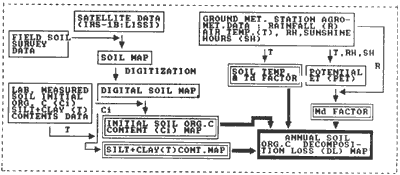
Figure 1 Flow diagram of Methodology for Modelling Soil Organic and Agro-Meteorological inputs
Figure 2 displays the spatial distribution of soilscape unit wise average initial sol organic carbon content of 0-50 cm soil depth of agro eco-systems of the study area, as estimated in the laboratory of the soil samples collected from various soil-scape nits. The initial soil organic carbon content (Ci) data indicated that Ci values ranged from 2.9 to 8l1 kg/m2 for various soilscape units of agro-ecosystem. Agro ecosystems with high intensity of cropping have higher values of initial soil organic carbon content (Ci).
Soilscape unit-wise average (silt + clay) content varies from 20% to 75% across the study area. Agro-ecosystem with older terraces/gently sloping piedmont plains soilscape unit have fine textured soils (Silt + clay content varies from 50% to 75%). Whereas, agro-ecosystem with sloping piedmonts/recent terrace/flood plains have medium to light textured soils (silt + clay content varies from 20% to 45%).

Figure 3 Soil (Silt + Clay) content of Agro-Ecosystem of Doon Vally
The amount of soil organic matter decomposed annually (lossed as microbial oxidation in the form of CO2), ranged from 0.13 to 0.34 Kg/m2, across the agro-ecosystems of the study area the agro-ecosystems having soils of higher amount of (silt + clay) contents had lower rate of organic matter decomposition.
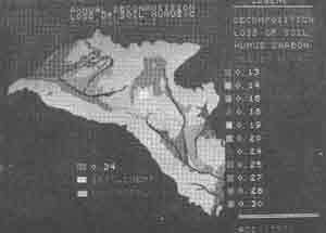
Figure 4 Spatial Distribution of Annul Decomposition Loss of Soil Orcanic Carbon of Agro-Ecosystem of Doon Valley
7. Conclusion
This study shows the potentially of use of satellite data in combination with agro-meterological and other ancillary soil data, for assessing agro-ecosystem soil organic matter decomposition following GIS aided integrated modeling approach.
Acknowledgement
The authors are thankful to Prof. B.L Deekshatulu, Director, N.R.S.A., Hyderababd and Prof. S.K. Bhan, Head I.I.R.S Dehradun (India) for the facilities, support and encouragement of carryout this study as a part of Technology Development Project (TDP).
References
Agro-ecosystem soil organic matter decomposition modeling is important for assessing the problems of sustained productivity matter status, and regional climatic change. A GIS based integrated methodology was developed for execution of CENTURY model ecosystem using satellite (IRS-LISS-I) derived soil map and soil characteristics; agro-meterological and ancillary soil data as inputs. The study area was Doon Valley (Dehradun district, Uttar Pradesh). This study demonstrates that agro-ecosystem soil organic matter decomposition can be adequately modeled following GIS based integrated approach using remote sensing inputs and other ancillary data of agro-meteorological and soils.
1. Introduction
The study of agro-ecosystem soil organic matter decomposition is important for assessing the problems of organic matter depletion in soil, long term soil fertility, sustained productivity of agro-ecosystems and regional climatic change.
A variety of soil parameters based models have been used by several researchers to represent short and long-term changes in single state variable model form to represent the decline of organic Cin cultivated sols. Van Veen and Paul (1981); Pastor and Post (1986); Parton et al. (1988) improved upon the approach different components. These models were mostly utilized for studying soil carbon dynamics of eco-systems of smaller areas based on ground collected soil data from various sites (point observations). At regional scale, the only appropriate instrument for monitoring carbon dynamics are satellite or aircraft based sensors. Remote sensing provides the needed dynamic temporal view of agro-ecosystems and large area coverage that eliminates the need for regional extrapolations based on small data sets.
The objective of this study was to develop an integrated methodology for execution of CENTURY model (Parton et. Ala., 1988) for assessment of agro-ecosystem soil organic matter decomposition using remote sensing derived soil; soil characteristics and agro-meteorological data as inputs.
2. The Century Model
In the original CENTRUY model (Parton et al., 1987) the soil organic matter (SOM) consists of three fractions. They constitute (i) an active fraction (active SOM) of soil C consisting of live microbes and microbial products, alongwith soil organic matter (SOM) with a short turnover time (1-5 years); (ii) a pool of C (slow SOM) that is physically protected and/or in chemical forms with more biological resistance to decomposition, with an intermediate turnover time (20-40 years), and (ii) a fraction that is protected with the longest turnover time (200-1500 years) (Parton et al. 1988).
In our soil organic matter decomposition modeling approach, we have consider only "active SOM" fraction of soil organic matter with a short turnover time. In soil system, a continuing loss of soil humus carbon (decomposition loss) taken place by microbial oxidization.
According to CENTRUY model, the rate of decomposition of soil organic matter depends on soil types; soil texture (silt + clay content); rainfall (R): soil temperature (Ts); Potential evapotranspiration (PET); initial soil organic carbon content (Ci) and the maximum decomposition rate parameter (Ki).
Decomposition (oxidation) loss (DL) of soil humus carbon is computed using the following expression (Parton et al., 1988)
where
T = (Sil + C1)
Md = f (PET, R)
Td = f (Ta)
Where, DL/dt is the rate of decomposition of soil hums carbon in time 't' (her, 1 years); T is soil silt (Sil) plus clay (C1) content; Md is the effect of moisture condition on decomposition rate (Md is the function of PET an dR); Td is the effect of average soil temperature on decomposition rate (Td is the funcorganic carbon content.
3. The Study Area
The study are comprises of Doon Valley (Dehradun district) of Uttar Pradesh and lies between 770 35' E to 780 19' E longitude and 29' 57' 30" N to 30' 30' 30" N latitude approximately. The climate of the region is sub-tropical (annual mean air temperature ranges between 130C to 230 C). The average rainfall of the area is ranged between 1130 mm to 2025 mm. The study area have variety of agro-ecosystems comprising mountain (Himalaya), hills (Siwalik), Piedmont plains, river terraces and flood plains as major physiographic units; various cultivated crops viz., paddy, wheat and sugarcane; ad Inceptisols, Entisols, Alfisols and Mollisols as dominant soils, in addition to climatic variability.
4. Data Used
The variety of data used in this study are IRS-1B LISS-I, FCCs of October, 1992 and March, 1993, of path-row 29-46; agro-climatic data of monthly rainfall, mean air temperature, relative humidity, sunshine hours etc. Survey of India topographical maps; field soil survey data and laboratory analyzed ples collected form sample sites of the area.
5. Methodology
The methodology adopted in this study consisted of various steps (Fig.1) and these are presented below:
Figure 1 Flow diagram of Methodology for Modelling Soil Organic and Agro-Meteorological inputs
- Preparation of physiographic-soil map: This was complished by visual interpretation of multi-temporal FCCs of IRS LISS-I based on image elements supplemented with terrain information by associating soil composition for each satellite interpreted soils cape units. Soil composition of physiographic units were established by studying soils in sample strips and by collecting data on soil characteristic obtained form soil profiles, mini-pits and augur bores (details of methodology are given in Saha and Singh, 1991).
- Generation of digitized soil map by digitization of satellite data derived soil map.
- Preparation of digital maps of initial soil organic carbon (Ci)
Content (Fig.2) and (Silt + clay - T) (Fig. 3) content by GIS aided
reclassification of digitized soil map using computerized laboratory
estimated data base on Ci and T data:
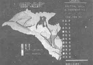
Figure 2 Initial average soil organic carbon content (0-50cm Soil Depth) of Agro-Ecosystem (crop Lands) of Doon Valley
- Computation of Md and Td factor values using agrometerological data-estimated Potential Evapotranspiraion (PET) values and by use of rainfall and air temperature data;
- Generation of map (Fig. 4) showing spatial distribution of annual decomposition rate of soil organic matter by GIS aided integration of digitized maps of soil, Ci and T and by use of computed values of Md, Td and Ki, following equation (1).
Figure 2 displays the spatial distribution of soilscape unit wise average initial sol organic carbon content of 0-50 cm soil depth of agro eco-systems of the study area, as estimated in the laboratory of the soil samples collected from various soil-scape nits. The initial soil organic carbon content (Ci) data indicated that Ci values ranged from 2.9 to 8l1 kg/m2 for various soilscape units of agro-ecosystem. Agro ecosystems with high intensity of cropping have higher values of initial soil organic carbon content (Ci).
Soilscape unit-wise average (silt + clay) content varies from 20% to 75% across the study area. Agro-ecosystem with older terraces/gently sloping piedmont plains soilscape unit have fine textured soils (Silt + clay content varies from 50% to 75%). Whereas, agro-ecosystem with sloping piedmonts/recent terrace/flood plains have medium to light textured soils (silt + clay content varies from 20% to 45%).
Figure 3 Soil (Silt + Clay) content of Agro-Ecosystem of Doon Vally
The amount of soil organic matter decomposed annually (lossed as microbial oxidation in the form of CO2), ranged from 0.13 to 0.34 Kg/m2, across the agro-ecosystems of the study area the agro-ecosystems having soils of higher amount of (silt + clay) contents had lower rate of organic matter decomposition.
Figure 4 Spatial Distribution of Annul Decomposition Loss of Soil Orcanic Carbon of Agro-Ecosystem of Doon Valley
7. Conclusion
This study shows the potentially of use of satellite data in combination with agro-meterological and other ancillary soil data, for assessing agro-ecosystem soil organic matter decomposition following GIS aided integrated modeling approach.
Acknowledgement
The authors are thankful to Prof. B.L Deekshatulu, Director, N.R.S.A., Hyderababd and Prof. S.K. Bhan, Head I.I.R.S Dehradun (India) for the facilities, support and encouragement of carryout this study as a part of Technology Development Project (TDP).
References
- Jenny, H (1942), Factors of soil formation, Mc Graw Hill, New York.
- Parton, J. and Post, W.M (1986) - Influence of climate, soil moisture and succession on forest carbon and nitrogen cycles, Bio-geochemistry, 2: 3-27.
- Parton, W.J; Stewart, J.W.B and Cole C.V (1988) - Dynamics of C, N,P and S in Grassland Soils - A model. Bio-geochemistry, 5 : 109-132.
- Saha, S.K and Sing, B.M, (1991) - Soil Erosion Assessment and Mapping of the Aglar River Waterheld (Uttar Pradesh)using Remote Sensing techniques, Jour. Ind. Soc. Rem. Sens. 19 (2) : 67-76.
- Van Veen, J.A and Paul, E.A (1981) - Organic C dynamics in grassland soils - I. Background information and computer simulation . Can.J.Soil Sci 61: 185-201.
- Parton, W..; Stewart, J.W.B. and Cole, C.V (1988) - Dynamics of C, N,P and S in Grassland Soils - A model. Bio-geochemistry, 5: 109-132.
- Shaha, S.K and Singh, B.M (1991) - Soil Erosion Assessment and Mapping of the Aglar River Watershed (Uttar Pardesh) using Remote Sensing techniques. Jour Ind. Soc. Rem. Sens., 19 (2) : 67-76.
- Van Veen, J.A and Paul, E.A (1981) - Organic C dynamics in grassland soils - I. Background information and computer simulation. Can J. Soil 61 : 185-201.