| GISdevelopment.net ---> AARS ---> ACRS 1994 ---> Poster Session |
Resource Constraint Mapping
in Mansa District, Punjab (India) using Remotely Sensed Data
V. K. Verma, Charanjit Singh, Rajiv Chopra and P. K. Sharma
Punjab Remote Sensing Centre
P. A. U. Campus, Ludhiana 141004
India
V. K. Verma, Charanjit Singh, Rajiv Chopra and P. K. Sharma
Punjab Remote Sensing Centre
P. A. U. Campus, Ludhiana 141004
India
Abstract
The nature, magnitude and spatial distribution of the problem areas can be assessed and monitored using remotely sensed data. Considering the immense potential of this technique, an attempt has been made to map physical, chemical and hydrological constraints in Mansa district of Punjab (India) which will be useful for preparing conservation and management plans for sustainable development. In the present study multidate remotely sensed data both in the form of aerial photographs and satellite image were interpreted visually for mapping soils and for obtaining a near real time information on flood inundation. Various thematic maps were integrated to prepare a constraint map. The study revealed that about 8.05% of the total area is under physical constraints i.e. sandy soils (sand dunes) whereas 1.38% area suffers from chemical constraints i.e. soil salinity and/or alkalanity and 6.41% of area suffers from hydrological constraints i.e. seasonal flooding and water logging. The area under both chemical and hydrological constraints comes out to be 0.11%. The study indicates that location specific measure like provision of new drains in areas susceptible to water logging and flooding, levelling and stabilisation of sand dunes, conjunctive use of surface and ground water, reclamation of salt affected lands, adopting salt tolerant crops, plantation of orchards and forest species, is the solution to these grave problems. On the basis of this study large scale photography of the area is recommended for preparing topographical maps with 2 meter contour interval.
1. Introduction
Accurate and reliable information on distribution of earth resources and the constraints is essential for preparation and execution of sustainable development programmers. The advent of remote sensing has opened new vistas for mapping and monitoring of natural resources (Karale et al 1985, Biswas 1987 and Kudrat et al 1992). The remote sensing technology is being widely used for mapping degraded lands in India (Sharma et al 1986, Teotia et al 1980, Manchanda and Iyer 1983, Sehgal and Sharma 1988 and Sehgal et al 1988 and Sehgal et al 1988). However, no attempt has been made to prepare a consolidated map showing the geographical locations and spatial distribution of different types of degraded lands for sustainable development in Mansa district. The study area experiences various problems like thick sand cover (sand dunes) in large area, poor retention of water and nutrients in coarse textured soils, soil salinity and/or alkanity, water logging and flooding. The area, being saucer shaped with no connection with Ghaggar river, also experiences local flooding. In view of this an attempt has been made to identify and demarcate the physical, chemical and hydrological constraints in Mansa district, Punjab (India).
2. Data Used
The black and white aerial photographs of March, 1988 on 1:50,000 scale and IRS-1A LISS II geocoded FCC (Oct., 1992 and March, 1993) generated from bands 2,3 and 4 were used for soil mapping. The IRS 1A LISS I FCC of July 1993 was interpreted to map the extent of flooding. The Survey of India topographical maps pertaining to the area were used to prepare base maps.
3. Methodology
The aerial photographs were interpreted using mirror stereoscope. Simultaneously, geocoded PCC (Oct., 1992 and March, 1993) were also interpreted visually. A detailed - reconnaissance soil survey of the area was undertaken following the methodology out lined in Soil Survey Manual (All India Soil and Land Use Survey, 1992). The morphological description and physico-chemical characteristics of the soils were correlated with physiography and a soil-physiography relationship was established. The final soil map was prepared on 1:50,000 scale. In order to map the flood inundated areas, the IRS-1A LISS I FCC of July 1993 were interpreted visually. The flood map prepared by Punjab Remote Sensing Centre during Sept. 1988 was also used to prepare a combined flood map of 1988 and 1993 showing the flood prone areas in the district. The physiography, soil and flood maps were integrated to come out with a constraint map of the area.
4. Results and Discussion
The Mansa district (comprising 219230 ha) has been divided into three major physiographic units, viz., alluvial plain, sand dunes and basins. These are further sub divided based on variation in photo elements such as colour, tone, texture, pattern, slope and landuse (Fig.1) The perusal of the map indicates that alluvial plain is nearly level, intensively cultivated, mostly irrigated and cover major portion of the area. Sand dunes, the remnants of fluviatile and aeolian action, occur as elongated stretches. These are 2 to 8 high above the alluvial plains. Basins are trough shape, localized depressions having salinity and /or alkalinity.
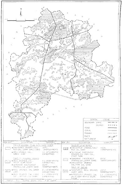
Figure 1 Soil Resource Map of Mansa District, Punjab
The combined flood map (fig. 2) show three categories :I) Are flooded in 1988 only ii) Area flooded in 1993 only and iii) Area flooded both in 1988 and 1993 i.e. flood prone areas. The physiography, soil and flood maps were integrated to come out with a constraint map (fig. 3). The constraints have been indentified and demarcated based on topographic features, existing natural drainage, soil conditions, soil salinity, susceptibility to water logging and flooding (Table 1)
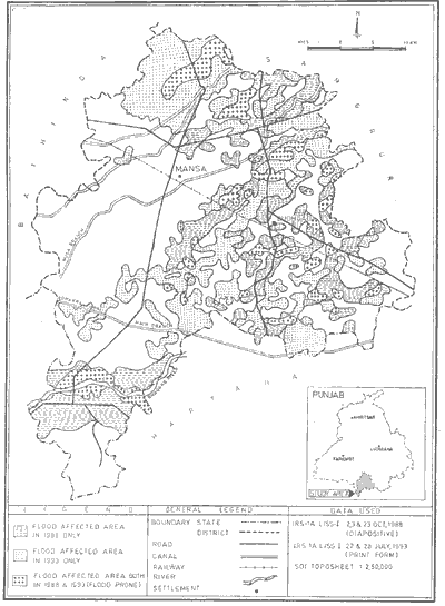
Figure 2 Flooding in Mansa District, Punjab (1988 & 1993)

Figure 3 Constraint Map of Mansa District, Punjab
Table 1: Nature and extent of constraints
The study shows the potential usefulness of the remote sensing technique in mapping natural resources of an area and integrating them to delineate problematic areas for sustainable development. The area has problems of sand dunes, soil salinity and/or alkalinity, water logging and flooding. The existing drainage system is inadequate to effectively drain out the excess water from the area and this further aggravates the problem. A large portion of the area lies in a saucer shaped depressional zone without any drainage outlet. The reclamation of these areas is required for sustainable development. Delineation of problematic areas of the district is the first step in this direction.
6. Recommendations
The study indicates that location specific measures like provision of new drains in areas susceptible to waster logging and flooding, levelling and stabilisation of sand dunes, conjunctive use of surface and ground water, reclamation of salt affected lands, adopting salt tolerant crops, plantation of orchards and forest species keeping in view the suitability of the area, is the solution to these grave problems. Drainage, as it is commonly understood, is only a flood control measure. But the reclamation of salt affected soils also calls for provision of adequate drainage measures for ameliorating soil salinity and/or alkalinity and water logging problems. The study recommends large scale photography for detailed contouring with 2 meter contour interval. This would enable the state's drainage and sewerage boards to strengthen the drainage network, and adopt stringent agricultural polices to maintain the same.
References
The nature, magnitude and spatial distribution of the problem areas can be assessed and monitored using remotely sensed data. Considering the immense potential of this technique, an attempt has been made to map physical, chemical and hydrological constraints in Mansa district of Punjab (India) which will be useful for preparing conservation and management plans for sustainable development. In the present study multidate remotely sensed data both in the form of aerial photographs and satellite image were interpreted visually for mapping soils and for obtaining a near real time information on flood inundation. Various thematic maps were integrated to prepare a constraint map. The study revealed that about 8.05% of the total area is under physical constraints i.e. sandy soils (sand dunes) whereas 1.38% area suffers from chemical constraints i.e. soil salinity and/or alkalanity and 6.41% of area suffers from hydrological constraints i.e. seasonal flooding and water logging. The area under both chemical and hydrological constraints comes out to be 0.11%. The study indicates that location specific measure like provision of new drains in areas susceptible to water logging and flooding, levelling and stabilisation of sand dunes, conjunctive use of surface and ground water, reclamation of salt affected lands, adopting salt tolerant crops, plantation of orchards and forest species, is the solution to these grave problems. On the basis of this study large scale photography of the area is recommended for preparing topographical maps with 2 meter contour interval.
1. Introduction
Accurate and reliable information on distribution of earth resources and the constraints is essential for preparation and execution of sustainable development programmers. The advent of remote sensing has opened new vistas for mapping and monitoring of natural resources (Karale et al 1985, Biswas 1987 and Kudrat et al 1992). The remote sensing technology is being widely used for mapping degraded lands in India (Sharma et al 1986, Teotia et al 1980, Manchanda and Iyer 1983, Sehgal and Sharma 1988 and Sehgal et al 1988 and Sehgal et al 1988). However, no attempt has been made to prepare a consolidated map showing the geographical locations and spatial distribution of different types of degraded lands for sustainable development in Mansa district. The study area experiences various problems like thick sand cover (sand dunes) in large area, poor retention of water and nutrients in coarse textured soils, soil salinity and/or alkanity, water logging and flooding. The area, being saucer shaped with no connection with Ghaggar river, also experiences local flooding. In view of this an attempt has been made to identify and demarcate the physical, chemical and hydrological constraints in Mansa district, Punjab (India).
2. Data Used
The black and white aerial photographs of March, 1988 on 1:50,000 scale and IRS-1A LISS II geocoded FCC (Oct., 1992 and March, 1993) generated from bands 2,3 and 4 were used for soil mapping. The IRS 1A LISS I FCC of July 1993 was interpreted to map the extent of flooding. The Survey of India topographical maps pertaining to the area were used to prepare base maps.
3. Methodology
The aerial photographs were interpreted using mirror stereoscope. Simultaneously, geocoded PCC (Oct., 1992 and March, 1993) were also interpreted visually. A detailed - reconnaissance soil survey of the area was undertaken following the methodology out lined in Soil Survey Manual (All India Soil and Land Use Survey, 1992). The morphological description and physico-chemical characteristics of the soils were correlated with physiography and a soil-physiography relationship was established. The final soil map was prepared on 1:50,000 scale. In order to map the flood inundated areas, the IRS-1A LISS I FCC of July 1993 were interpreted visually. The flood map prepared by Punjab Remote Sensing Centre during Sept. 1988 was also used to prepare a combined flood map of 1988 and 1993 showing the flood prone areas in the district. The physiography, soil and flood maps were integrated to come out with a constraint map of the area.
4. Results and Discussion
The Mansa district (comprising 219230 ha) has been divided into three major physiographic units, viz., alluvial plain, sand dunes and basins. These are further sub divided based on variation in photo elements such as colour, tone, texture, pattern, slope and landuse (Fig.1) The perusal of the map indicates that alluvial plain is nearly level, intensively cultivated, mostly irrigated and cover major portion of the area. Sand dunes, the remnants of fluviatile and aeolian action, occur as elongated stretches. These are 2 to 8 high above the alluvial plains. Basins are trough shape, localized depressions having salinity and /or alkalinity.
Figure 1 Soil Resource Map of Mansa District, Punjab
The combined flood map (fig. 2) show three categories :I) Are flooded in 1988 only ii) Area flooded in 1993 only and iii) Area flooded both in 1988 and 1993 i.e. flood prone areas. The physiography, soil and flood maps were integrated to come out with a constraint map (fig. 3). The constraints have been indentified and demarcated based on topographic features, existing natural drainage, soil conditions, soil salinity, susceptibility to water logging and flooding (Table 1)
Figure 2 Flooding in Mansa District, Punjab (1988 & 1993)
Figure 3 Constraint Map of Mansa District, Punjab
| Physiography | Type of Constraints | Nature of Constraints | Area ha | % of total area |
| 1. Alluvial plain | - | - | 184226 | 84.03 |
| 2. Sand dunes | Physical | Sandy texture of soils | 17659 | 8.05 |
| 3. Basin | Chemical | Soil salinity &/or alkalinity | 3028 | 1.28 |
| 4. Alluvial plain (Low lying) | Hydrological | Flooding and water logging | 14074 | 6.41 |
| 5. Alluvial plain (Low lying) | Chemical and hydrological | Soil salinity, flooding and water logging | 243 | 0.11 |
- Physical constraints
The sand dunes covering an area of 17659 ha (8.05%) show physical constraints. The have coarse textured soils (sand and loamy sand), with poor nutrients and water holding capacity. These are of fluvial as well as of aeolian origin. South western winds have played a prominant role in their formation. The sand dunes occur in localised patches and have aligned along the prominant wind direction i.e. SW-NE. The palaeochannels of the Satluj river are clearly seen on the imagery. They show preferred alignment of sand dunes striking SW-NE. Due to physical constraints the sand dunes are rarely cultivated. - Chemical constraints
The geological facts reveal that Mansa district forms a part of Indo-Gangetic alluvium of Quaternary age (G.S.I., 1976). The sand dunes found in the district are of fluvial origin deposited b the ancient Satluj river which was flowing through the area. Later the river shifted its course towards the northern side. In the present landscape the continuity of palaeochannels has been broken forming basins in the area. The basins, due to their lower topographic position have soil salinity and/or alkalinity. Seepage from canals and surrounding uplands (under paddy cultivation) has resulted in the rise of water table which finally led to development of soil salinity in the low lying areas. In the district, the problem of soil salinity and/or alkalinity has come in recent years due to rise in water table since 1980-81. The salt affected lands are localised in south eastern part of the district (Budhlada and Jhunir areas). The basins are observed as dark concave meander curves on the aerial photographs and satellite imagery. There are two drains namely Bahadur Singh Nala and Bereta drain, running parallel to each other near Mansa and Bereta respectively. These are ineffective and non functional which further aggravates the problem. The chemical characteristics of the studied pedons reveal that the pH of the soils vary from 8.7 to 10.4 EC of the surface horizons ranges from 2.9 to 15.9 mmhos/cm. The exchangeable sodium percentage of the soils varies from 15-65. The dominant cations in the exchange complex are Na+, Ca++ and Mg++. The high concentration of salts pose constraints for plant growth. The are under this unit comes out to be 3028 ha. - Hydrological constraints
The low lying alluvial plain experiencing hydrological constraints is prone to flooding. This cover an area of 14074 ha (6.41) The area has no major river except Ghaggar which is seasonal and passes through the southern part of the district. The bed of the river is shallow, causing floods every ear during monsoons. The perusal of the flood map indicates that part of the district experiences hydrological constraints due to local flooding as a result of ineffective and non-functional drainage system and overflow of Ghaggar river. The satellite imagery of July 1993 clearly indicates that this area has no connection with Ghaggar river to drain out the excess water. Blockage of natural flow of water by Bhakhra Main Line during floods can be clearly seen in the imagery.
The study shows the potential usefulness of the remote sensing technique in mapping natural resources of an area and integrating them to delineate problematic areas for sustainable development. The area has problems of sand dunes, soil salinity and/or alkalinity, water logging and flooding. The existing drainage system is inadequate to effectively drain out the excess water from the area and this further aggravates the problem. A large portion of the area lies in a saucer shaped depressional zone without any drainage outlet. The reclamation of these areas is required for sustainable development. Delineation of problematic areas of the district is the first step in this direction.
6. Recommendations
The study indicates that location specific measures like provision of new drains in areas susceptible to waster logging and flooding, levelling and stabilisation of sand dunes, conjunctive use of surface and ground water, reclamation of salt affected lands, adopting salt tolerant crops, plantation of orchards and forest species keeping in view the suitability of the area, is the solution to these grave problems. Drainage, as it is commonly understood, is only a flood control measure. But the reclamation of salt affected soils also calls for provision of adequate drainage measures for ameliorating soil salinity and/or alkalinity and water logging problems. The study recommends large scale photography for detailed contouring with 2 meter contour interval. This would enable the state's drainage and sewerage boards to strengthen the drainage network, and adopt stringent agricultural polices to maintain the same.
References
- All India Soil and Land Use Survey (1972). Soil Survey Manual (Revised). I.A.R.I., New Delhi
- Biswas R.R. (1987). A Soil map through Landsat satellite imagery - in a part of Aurange Catchment in the Ranchand Palamou district of Bihar, India. Int. J. Rem. Sens., 8:541-543.
- GSI (1976). Know your district-Bathinda, Punjab. Geological Survey of India.
- Karale (1976). R.L., K.V. Seshagiri Rao, L.Venkataratnam and T.V. Malleswar (1985). Visual and digital techniques of remote sensing for soils and landuse mapping. Proc. 6th Asian Conf. Rem. Sens., Hyderabad. pp 61-67.
- Kudrat M., A.K. Tiwari, S.K. Bhan (1992). Soil resource mapping using IRS-1A LISS II digital data - A case study of Kandi area adjacent to Chandigarh, India. Int. J. Remote Sensing, 13: 2287-2302.
- Manchanda M.L. and H.S. Iyer (1983). Use of Landsat imagery and aerial photographs for delineation and categorization of salt affected soils of part of NW India. J. Indian Soc. Soil Science, 31(1): 263-271.
- Sharma P.K., J.L. Sehagal and K.R. Sharma (1986). Mapping salt-affected soils in Sangrur district (Punjab) - using aerial photo-interpretation technique. Photonirvachak: J. Indian Soc. Remote Sensing, 4: 43-54.
- Sehgal J.L., P.K. Sharma (1988). An inventory of degraded soils of Punjab (India) using remote sensing techniques. Soil Survey and Land Evaluation (UK), 8(3): 166-175.
- Sehgal J.L., P.K. Sharma and R.L. Karale (1988). Soil resource inventory of Punjab using remote sensing technique. J. Indian Soc. Remote Sensing, 16: 39-47.
- Teotia H.S., J.D. Hoore and R. Gombeer (1980). Soil and land use distribution over a part of north plains (Indo-Gangetic Plains) of India, based on the optical interpretation of Landsat 2, multispectral satellite imagery. Pedologie, 30: 19-42.