| GISdevelopment.net ---> AARS ---> ACRS 1994 ---> Mapping from Space |
GPS Application to Optimize
the Utilization of Remote Sensing
Edi Sutopo
PT Mapindo Parama, Jakarta, Indonesia
PT Mapindo Parama, Jakarta, Indonesia
Abstract
Remote sensing continually improves whether considered from medium aspect for example aerial photography, satellite image Landsat and SPOT, radar from airborne and from space for example ERS-1, JERS and Radarsat or considered from data accuracy aspect that increasingly smaller resolution of pixel size that is 9mx9m resolution from Radarsat. This improvement will get more data and better information about the earth surface. nevertheless, the position of information still in the relative position. In the positioning aspect also improve especially in global positioning system (GPS) that it can measure the position in submitter accuracy using differential method positioning. Integration system to global information system in GIS.
I. Introduction
Global issue in development is sustainable development, that is the development that doesn't damaging the environment, the development with minimized damage, the development that always go on continually until descendant, the development will give long term result.
The sustainable development can be well implemented when the intial data available from natural resources inventory. Natural resources is the first step in the direction of sustainable development.
Monitoring of the development output must be implemented in order to know the changing or the damage in the world immediately without waiting serious damage happen. With the continue monitoring can be followed the progress of the development in anytime.
II. Remote Sensing
Monitoring from time to time at the samearea will get the multi-temporal data. These data will be important because it can be used for changing analysis, the changing to destruction or the changing to improvement and what the speed of the changing.
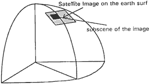
Satellite image on the earth surface
Remote sensing technology is increasingly better in presenting the quality of data. The size of pixel more and more sma..er, from 80 meters to 9 meters, so it can extract data on the earth surface more detail. Smaller object on earth surface can be detected. The all life aspect can utilize this system for analysis their requirement better.
More platform, that is Landsat TM from USA, SPOT from France, ERS-1 from Europe, JERS-1 from Japan, IRS from India, NOAA has been lunching and operating to take the image of earth surface with different sensor, that is active sensor or passive sensor and more range variation of bands. Radarsat will be launch in 1995.
Remote sensing from airborne are using passive sensor like panchromatic, infra red in black & white or in color or active sensor using radar. Some airborne radar sensor using C band or L band.
Today, the user can select the satellite image that match with their requirement based on variation of bond or the type of sensor or size of pixel. With on-line network facilities also make easy to get and to select the image they want at approximate at the on time. Portable ground station also make easier to get satellite image from anywhere.
System software for image processing more sophisticated, that is Easy,Pace, Erdas, ER Mapper, Micro Brian and more make easy for the user to do image processing. The user can choose the software from simple processing until complex processing that match with their hardware and requirement. The user can analysis all aspect information at surface of the earth.
III. Global Positioning System
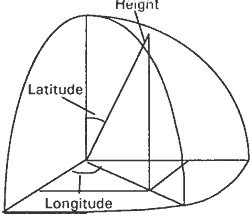
Satellite positioning has been launching for three dimensional positioning, that is Latitude, Longitude and the Height from ellipsoid. This position based on geocentric ellipsoid, using WGS 84 ellipsoid.
Positioning using GPS can be done at anywhere and at any time because the satellite constellation has been completed, that is 18 satellite operated and 3 satellite for spare. Window time already reduced by completion of satellite launching.
GPS receiver, from very simple until very complex, from single channel to double channel, from cheapest to expensive are available in market. The user can be choose what they need. Variation of the usage, from navigation, GSP has wide user.
The accuracy that can be reach by GSP positioning may variation, from 50 meters to less than 1 meter, it's depend on the methodology. Once again, the accuracy can be match with the user requirement.
In the large scale mapping, the image can be taken from airborne whether using aerial photography or radar need more ground control point. In the dense forest especially in Indonesian tropical forest very difficult to do the positioning although using GPS, because positioning using GPS have to free obstacle. In the dense forest, the big problem is accommodation and transportation. GPS give possibility to make easier for positioning using kinematic positioning.
Coordinate from GPS
IV. Geographic Information System
Geographic Information System (GIS) is a system to catch the data from inventory and then analyze the data for specific application. Some software can handle two type of data, vector and raster data.
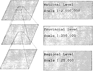
The Indonesia's natural Resources GIS (INRGIS) uses three level of scale, that is 1:2.500.00 for national level, 1:250.000 for provincial level and 1:25,000 for regional level. In order to tied up the same information on different level, in every level has to use the same coordinate, that is geographic coordinate (latitude, longitude). So, when the changing information was known in the regional level, this changing must be updated on provincial and national level.
Indonesia's Natural Resources GIS
V. Analysis
The pixel size more and more smaller, so must be followed by increasing the accuracy of positioning of ground control point that will be use for geometric correction. For example, in updating base mapping at scale 1:250.000, if ground control point measured from digitized point at those map, thus digitizing error .5 mm will equivalent 125m on the ground, this is not proportional with the pixel size (10m). In this manner smaller pixel size doesn't meaning to improve map was caused mistake in the methodology.
To optimize GPS utilization for map improvement and map updating, signalization can be done in the field with good reflector for the type of sensor in order to get clear position of ground control point.
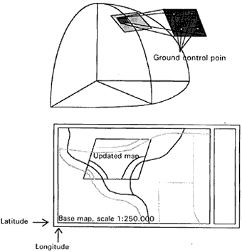
Matching the updated map to the base map coordinat
Remote sensing continually improves whether considered from medium aspect for example aerial photography, satellite image Landsat and SPOT, radar from airborne and from space for example ERS-1, JERS and Radarsat or considered from data accuracy aspect that increasingly smaller resolution of pixel size that is 9mx9m resolution from Radarsat. This improvement will get more data and better information about the earth surface. nevertheless, the position of information still in the relative position. In the positioning aspect also improve especially in global positioning system (GPS) that it can measure the position in submitter accuracy using differential method positioning. Integration system to global information system in GIS.
I. Introduction
Global issue in development is sustainable development, that is the development that doesn't damaging the environment, the development with minimized damage, the development that always go on continually until descendant, the development will give long term result.
The sustainable development can be well implemented when the intial data available from natural resources inventory. Natural resources is the first step in the direction of sustainable development.
Monitoring of the development output must be implemented in order to know the changing or the damage in the world immediately without waiting serious damage happen. With the continue monitoring can be followed the progress of the development in anytime.
II. Remote Sensing
Monitoring from time to time at the samearea will get the multi-temporal data. These data will be important because it can be used for changing analysis, the changing to destruction or the changing to improvement and what the speed of the changing.
Satellite image on the earth surface
Remote sensing technology is increasingly better in presenting the quality of data. The size of pixel more and more sma..er, from 80 meters to 9 meters, so it can extract data on the earth surface more detail. Smaller object on earth surface can be detected. The all life aspect can utilize this system for analysis their requirement better.
More platform, that is Landsat TM from USA, SPOT from France, ERS-1 from Europe, JERS-1 from Japan, IRS from India, NOAA has been lunching and operating to take the image of earth surface with different sensor, that is active sensor or passive sensor and more range variation of bands. Radarsat will be launch in 1995.
Remote sensing from airborne are using passive sensor like panchromatic, infra red in black & white or in color or active sensor using radar. Some airborne radar sensor using C band or L band.
Today, the user can select the satellite image that match with their requirement based on variation of bond or the type of sensor or size of pixel. With on-line network facilities also make easy to get and to select the image they want at approximate at the on time. Portable ground station also make easier to get satellite image from anywhere.
System software for image processing more sophisticated, that is Easy,Pace, Erdas, ER Mapper, Micro Brian and more make easy for the user to do image processing. The user can choose the software from simple processing until complex processing that match with their hardware and requirement. The user can analysis all aspect information at surface of the earth.
III. Global Positioning System
Satellite positioning has been launching for three dimensional positioning, that is Latitude, Longitude and the Height from ellipsoid. This position based on geocentric ellipsoid, using WGS 84 ellipsoid.
Positioning using GPS can be done at anywhere and at any time because the satellite constellation has been completed, that is 18 satellite operated and 3 satellite for spare. Window time already reduced by completion of satellite launching.
GPS receiver, from very simple until very complex, from single channel to double channel, from cheapest to expensive are available in market. The user can be choose what they need. Variation of the usage, from navigation, GSP has wide user.
The accuracy that can be reach by GSP positioning may variation, from 50 meters to less than 1 meter, it's depend on the methodology. Once again, the accuracy can be match with the user requirement.
In the large scale mapping, the image can be taken from airborne whether using aerial photography or radar need more ground control point. In the dense forest especially in Indonesian tropical forest very difficult to do the positioning although using GPS, because positioning using GPS have to free obstacle. In the dense forest, the big problem is accommodation and transportation. GPS give possibility to make easier for positioning using kinematic positioning.
Coordinate from GPS
IV. Geographic Information System
Geographic Information System (GIS) is a system to catch the data from inventory and then analyze the data for specific application. Some software can handle two type of data, vector and raster data.
The Indonesia's natural Resources GIS (INRGIS) uses three level of scale, that is 1:2.500.00 for national level, 1:250.000 for provincial level and 1:25,000 for regional level. In order to tied up the same information on different level, in every level has to use the same coordinate, that is geographic coordinate (latitude, longitude). So, when the changing information was known in the regional level, this changing must be updated on provincial and national level.
Indonesia's Natural Resources GIS
V. Analysis
The pixel size more and more smaller, so must be followed by increasing the accuracy of positioning of ground control point that will be use for geometric correction. For example, in updating base mapping at scale 1:250.000, if ground control point measured from digitized point at those map, thus digitizing error .5 mm will equivalent 125m on the ground, this is not proportional with the pixel size (10m). In this manner smaller pixel size doesn't meaning to improve map was caused mistake in the methodology.
To optimize GPS utilization for map improvement and map updating, signalization can be done in the field with good reflector for the type of sensor in order to get clear position of ground control point.
Matching the updated map to the base map coordinat
| Satellite | Scanner | Band | Wavelength | Ground Resolution (m) | Cover km | ||
| Landsat | MSS | 1 | .5 | - | .6 | 79 | 185 |
| 2 | .6 | - | .7 | ||||
| 3 | .7 | - | .8 | ||||
| 4 | .8 | - | 1.1 | ||||
| Landsat | TM | 1 | .45 | - | .52 | 30 | 185 |
| 2 | .52 | - | .60 | ||||
| 3 | .63 | - | .69 | ||||
| 4 | .76 | - | .90 | ||||
| 5 | 1.55 | - | 1.75 | ||||
| 6 | 10.3 | - | 12.5 | 120 | |||
| SPOT | HRV | 1 | .50 | - | .59 | 20 | 60 |
| 2 | .61 | - | .68 | ||||
| 3 | .79 | - | .89 | ||||
| Panchromatic | .51 | - | .73 | 10 | 60 | ||
| Radarsat | Standard | C | 25 | 100 | |||
| Wide (1) | C | 48-25 | 165 | ||||
| Wide (2) | C | 32-25 | 150 | ||||
| Fine Res. | C | 11-9 | 45 | ||||
| ScanSAR (nar) | C | 50 | 305 | ||||
| ScanSAR (nar) | C | 100 | 510 | ||||
| Extended (H) | C | 22-19 | 75 | ||||
| Extended (L) | C | 63-29 | 170 | ||||
| ERS -1 | C | 26 | 100 | ||||
| JERS - 1 | L | 18 | 75 | ||||
| Almaz | S | 15-30 | 20-45 | ||||
| Seasat | L | 25 | 100 | ||||