| GISdevelopment.net ---> AARS ---> ACRS 1994 ---> Mapping from Space |
Mapping by Graphical Method
using Remotely Sensed Data (A Case Study)
H. S. Mehta
Professor in Civil Engg. & Incharge, Remote Sensing Cell,
Department of Civil Engg. , S.G.S.I.T.S., Indore (M.P.) India
M. K. Ozha
Director, Bharati Enterprises,
124-C Special, Gandhi Nagar, Indore - 453 112 (M . P.) India
H. S. Mehta
Professor in Civil Engg. & Incharge, Remote Sensing Cell,
Department of Civil Engg. , S.G.S.I.T.S., Indore (M.P.) India
M. K. Ozha
Director, Bharati Enterprises,
124-C Special, Gandhi Nagar, Indore - 453 112 (M . P.) India
Abstract
The survey for medium size project on large scale by conventional techniques is time consuming and ver uneconomical. This is achieved b using rectified large scale photographs but cost of aerial photographs and process of obtaining them is very expensive and difficult for other users than survey of India. Even for the scientists of survey of India, either they have to go for large scale rectified aerial photographs or Photogrammetric plotting machines. Since the space borne data is free from height and tilt distortion a case study have been taken up to explore possibility of mapping by graphical method using space borne data.
The test site is comprising of co-ordinates :
N 220 40' - N 220 45'
E 750 55' - E 760 00'
The data set used for this case study is in the form of F.C.C. of Spot-1 and IRS-1A-LISS-II alongwith the collateral data in the form of topo maps of survey of India
Introduction
Medium scale project survey work is the work which is very time consuming by traditional method and very costly be modern instrumental method of preparing maps. Its is fairly easy to survey using rectified photographs as base for Planimetric control and survey contours and verification of details on the ground, but the process of obtaining rectified photographs from Survey of India is not only very time consuming and cumbersome but provides only information about the area on the date of photography which at times may be 5 be 10 years old. Since survey of medium scale projects are of time bound specification and time consumed in getting rectified prints and cost could not be afforded by either indenture or the surveyors in private sectors. Survey of India topo sheets can be used for this purpose but they are too old to incorporate new items. Remotely sensed data is easily obtainable and fairly current but one has to have sophisticated mechanism and expertise to use them for the purpose.
With the view to overcome such difficulties authors have tried a middle path of getting planimetrically corrected details for the purpose of rigorous survey on the ground. A case study has been carried out to explore the possibilities of preparing maps using space borne data b graphical method.
Space borne data in the form of F.C.C. of Spot -1 and IRS -1A - LISS II, collateral data - Survey of India topographical maps of 1:50,000 scale were used for this case study.
Methodology
The enlarge prints on scale 1:250, 000 of space borne data were obtained and the main details such as tracks, streams, railway lines on Procon - III and were chalked out on paper prints. Four well defined sharp objects in the form of track junction, stream junction or edge of tank bunds has been identified and selected on map and imagery, These points were so selected that they cover sufficiently large distance to serve as the base of further survey work. These co-ordinates were obtained from Survey of India map and were plotted on a clear mylar sheet. Now using graphical method of preparing maps an graphic triangulation for different points of the details was carried out. Then using these position of points other details have been interpolated to form a base map for rigorous ground survey.
Results and Discussions
Different visual image processing techniques have been employed for feature enhancement, extraction and sharpening on F.C.C. of Spot-1 satellite and IRS -1A - IRS -1A-LISS - II imageries and near by reason to increase indentifiability of features that have been identified are roads, water bodies, railway lines, barren land, settlement, associate buildings, wide field bunds etc. for multispectral band, the identification key have been generated for extracted features have been shown in Table 1.
Table 1 Identification Key for Spot XS Band
On comparison the map prepared with toposheet it is found that accuracy of such maps are within 0.3 mm. but at the same time so many new details are available on map prepared by us. On verification in ground, it is observed that the accuracy of detail is quite satisfactory and the same can be used as base map for further ground verification and contouring.
Conclusions
The authors have found that it is possible to prepare a base map for ground verification and small contour interval survey for medium size project maps at considerably short period with considerable cost benefit ratio. Map prepared by authors have been shown in Appendix-1.
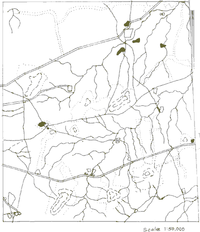
Appendix - 1
Acknowledgement
Authors are thankful to Dr. J.P. Sshrivastava, Director, S.G.S.I.T.S., Indor for his whole hearted encouragement and permission to carryout experiment in the Institute.
References
The survey for medium size project on large scale by conventional techniques is time consuming and ver uneconomical. This is achieved b using rectified large scale photographs but cost of aerial photographs and process of obtaining them is very expensive and difficult for other users than survey of India. Even for the scientists of survey of India, either they have to go for large scale rectified aerial photographs or Photogrammetric plotting machines. Since the space borne data is free from height and tilt distortion a case study have been taken up to explore possibility of mapping by graphical method using space borne data.
The test site is comprising of co-ordinates :
N 220 40' - N 220 45'
E 750 55' - E 760 00'
The data set used for this case study is in the form of F.C.C. of Spot-1 and IRS-1A-LISS-II alongwith the collateral data in the form of topo maps of survey of India
Introduction
Medium scale project survey work is the work which is very time consuming by traditional method and very costly be modern instrumental method of preparing maps. Its is fairly easy to survey using rectified photographs as base for Planimetric control and survey contours and verification of details on the ground, but the process of obtaining rectified photographs from Survey of India is not only very time consuming and cumbersome but provides only information about the area on the date of photography which at times may be 5 be 10 years old. Since survey of medium scale projects are of time bound specification and time consumed in getting rectified prints and cost could not be afforded by either indenture or the surveyors in private sectors. Survey of India topo sheets can be used for this purpose but they are too old to incorporate new items. Remotely sensed data is easily obtainable and fairly current but one has to have sophisticated mechanism and expertise to use them for the purpose.
With the view to overcome such difficulties authors have tried a middle path of getting planimetrically corrected details for the purpose of rigorous survey on the ground. A case study has been carried out to explore the possibilities of preparing maps using space borne data b graphical method.
Space borne data in the form of F.C.C. of Spot -1 and IRS -1A - LISS II, collateral data - Survey of India topographical maps of 1:50,000 scale were used for this case study.
Methodology
The enlarge prints on scale 1:250, 000 of space borne data were obtained and the main details such as tracks, streams, railway lines on Procon - III and were chalked out on paper prints. Four well defined sharp objects in the form of track junction, stream junction or edge of tank bunds has been identified and selected on map and imagery, These points were so selected that they cover sufficiently large distance to serve as the base of further survey work. These co-ordinates were obtained from Survey of India map and were plotted on a clear mylar sheet. Now using graphical method of preparing maps an graphic triangulation for different points of the details was carried out. Then using these position of points other details have been interpolated to form a base map for rigorous ground survey.
Results and Discussions
Different visual image processing techniques have been employed for feature enhancement, extraction and sharpening on F.C.C. of Spot-1 satellite and IRS -1A - IRS -1A-LISS - II imageries and near by reason to increase indentifiability of features that have been identified are roads, water bodies, railway lines, barren land, settlement, associate buildings, wide field bunds etc. for multispectral band, the identification key have been generated for extracted features have been shown in Table 1.
| S. No. | Feature | Tone / Colour | Texture | Size | Shape | Pattern | Association |
| 1. | Railway | Dark grey | Medium | Fixed | Long Straight | Linear | Cultivated or uncultivated land. |
| 2. | Roads | Dark grey | Fine | Variable | Straight with sharp bends | -do- | Building and barren land |
| 3. | Barren land | White to light grey | Fine | Variable | Open | Dispersed | - |
| 4. | Water bodies | Dark grey | Fine | Variable | Round or variable | Irregular or Dispersed | Vegetation and hill. |
| 5. | River & Stream | Dark grey | Fine | Variable | Variable | Linear | Cultivated land and settlements |
| 6. | Hills | Greenish Blue | Coarse | Variable | Irregular | Dispersed | - |
| 7. | Residen- tial area |
Bright white to dull blue with patches | Medium | Variable | Variable | Regular | A group of houses |
| 8. | Urban area | Light blue to bright white | Medium | Variable | Variable | Rectan- gular |
Roads. |
On comparison the map prepared with toposheet it is found that accuracy of such maps are within 0.3 mm. but at the same time so many new details are available on map prepared by us. On verification in ground, it is observed that the accuracy of detail is quite satisfactory and the same can be used as base map for further ground verification and contouring.
Conclusions
The authors have found that it is possible to prepare a base map for ground verification and small contour interval survey for medium size project maps at considerably short period with considerable cost benefit ratio. Map prepared by authors have been shown in Appendix-1.
Appendix - 1
Acknowledgement
Authors are thankful to Dr. J.P. Sshrivastava, Director, S.G.S.I.T.S., Indor for his whole hearted encouragement and permission to carryout experiment in the Institute.
References
- Manual of Photogrammetry, Vol. I and II, American Society of Photogrammetry, Virginia, USA.
- Filisand, T.M. and Kiefer, R.W. (1979). Remote Sensing and image Interpretation, John Wiley, New York.